the Creative Commons Attribution 4.0 License.
the Creative Commons Attribution 4.0 License.
 | 21 Nov 2022
Geophysical evidence of massive hyperconcentrated push waves with embedded toma hills caused by the Flims rockslide, Switzerland
Michael Schwenk
Michael Krautblatter
Rockslides and rock avalanches are amongst the most destructive natural hazards in the alpine environment. The Flims rockslide is the largest known rock-slope failure in the Alps, which provides excellent outcrops and has fascinated researchers since the early 20th century. The postulated impact of the Flims rockslide on Lake Bonaduz caused intensely fluidized rock material, which formed the Bonaduz Formation and toma hills, probably accompanied by a catastrophic impact wave. So far, this hypothesized sequence of events is based only on sedimentological and geomorphic analyses. We present electrical resistivity tomography (ERT) profiles, which we correlated with the sedimentological information obtained from outcrops and drill logs. Here, geophysical evidence on a metre and decametre scale complements prior outcrop and sample intervals with much smaller representativeness. Our study provides new insights into the distribution, thickness, and internal structure of the Bonaduz Formation and the toma hills as well as other flood deposits around the Ils Aults, where we studied the sediment to a depth of up to 160 m. There is geophysical evidence that the Bonaduz Formation formed an onlap onto the Ils Aults and is thus the stratigraphically younger unit. The toma hills consist of blocky cores with an agglomeration of smaller mixed sediments, which drift and override the toma core, causing their smoothly shaped top. We consider simultaneous transport of the hills within the Bonaduz Formation but a slightly slower movement at the front due to a bulldozing effect. This study contributes to an improved understanding of (i) the complex stratigraphical context of the Tamins and Flims deposits, (ii) water-rich entrainment in rock avalanches, and (iii) the genesis and transport of toma hills.
- Article
(6589 KB) - Full-text XML
-
Supplement
(464 KB) - BibTeX
- EndNote


The Flims rockslide deposit is located in the Vorderrhein valley, Eastern Switzerland. With its deposits comprising a volume of 10–12 km3 and covering an area of ∼52 km2 (Heim, 1932; Abele, 1974; Poschinger, 2006), the Flims rockslide is the largest known catastrophic Alpine rock-slope failure. Along a major thrust fault, the U-shaped W–E-directed Rhine valley tectonically separates the Triassic to Cretaceous sedimentary rocks of the Helvetic nappes to the north from metasedimentary rocks of the Penninic nappes to the south (Pfiffner et al., 2002). The Flims rockslide detached from the northern valley flank and mainly comprises Jurassic limestone from the Quinten Formation. The rockslide partially transformed into a rock avalanche during its descent, which increased its runout distance (Pollet and Schneider, 2004; Schneider et al., 2004; Aaron et al., 2020). In the following, we simply refer to the Flims rock-slope failure as a rockslide. The deposits had originally been thought to be of a late-glacial age. Based on radiocarbon and cosmogenic nuclide dating, however, the Flims rockslide was dated to a mean age of ∼9000 cal BP (Poschinger and Haas, 1997; Schneider et al., 2004; Deplazes et al., 2007; Ivy-Ochs et al., 2009).
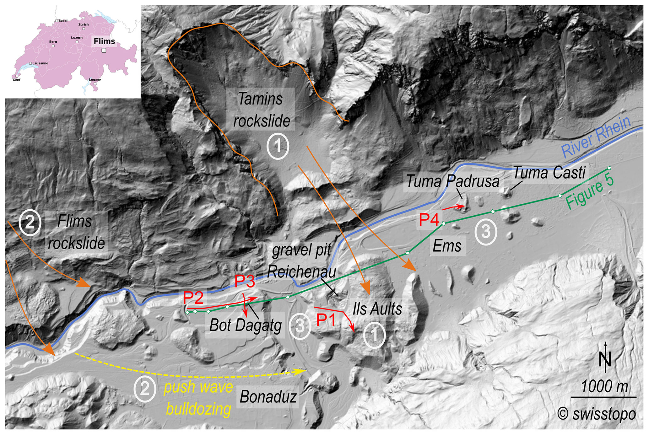
Figure 1Overview of the study area in the Rhein River valleys depicting the scarp of the Tamins rockslide, the Ils Aults consisting of Tamins deposits, and parts of the impact zone of the Flims rockslide and toma hills (e.g. Bot Dagatg, Tuma Padrusa, and Tuma Casti). The ERT profiles P1–P4 (Fig. 4) are marked with red colour. The green profile links drilling sites (white markers) and is shown in Fig. 5. The circled numbers correspond to the evolution phases. High-resolution digital elevation model (DEM): © swisstopo.
The stratigraphical relationship to the neighbouring Tamins rockslide (Fig. 1), however, is still a matter of debate. The local stratigraphy and morphology provide evidence that the Tamins rockslide had dammed a paleolake, Lake Bonaduz, which the Flims rockslide presumably impacted (Poschinger et al., 2006; Poschinger and Kippel, 2009; Calhoun et al., 2015; Calhoun and Clague, 2018). Upon impact into Lake Bonaduz and into the sedimentary valley fill (Scheller, 1970; Calhoun and Clague, 2018), the Flims rockslide brought a volume of several 100×106 m3 of sediment into suspension, evoked by the immense energy input of push waves. The resulting hyperconcentrated mass flow (Calhoun and Clague, 2018) transported slabs of the impacting rock mass on top and was deposited as the Bonaduz Formation (Wyss and Wiederkehr, 2017), a characteristic graded but unstratified sediment with rip-up clasts of silt and sandstones and rock avalanche material (Fig. 2a–c) that forms a plain between the Flims and Tamins rockslide deposits (Fig. 1; Pavoni, 1968; Poschinger et al., 2006; Poschinger and Kippel, 2009; Poschinger and Ruegg, 2012). Embedded in this plain, the rock slabs were deposited as toma (Figs. 1 and 2d–f), i.e. isolated cone- to pyramid- or roof-shaped hills composed of Helvetic bedrock material (Abele, 1974). Around the Ils Aults, there are three different terms for these hills. According to Arbenz and Staub (1910), the long hills situated in the Bonaduz plain are called “Cresta”, whereas the round or cone-shaped hills containing rockslide material are called “Toma” around Ems and “Put” around Bonaduz (see Fig. 1 for locations). Piperoff (1897) and Arbenz and Staub (1910) interpreted the caps on top of the hills initially as moraine deposits but only few outcrops were known. Henceforth, we refer to all these morphologically variable hills as toma.
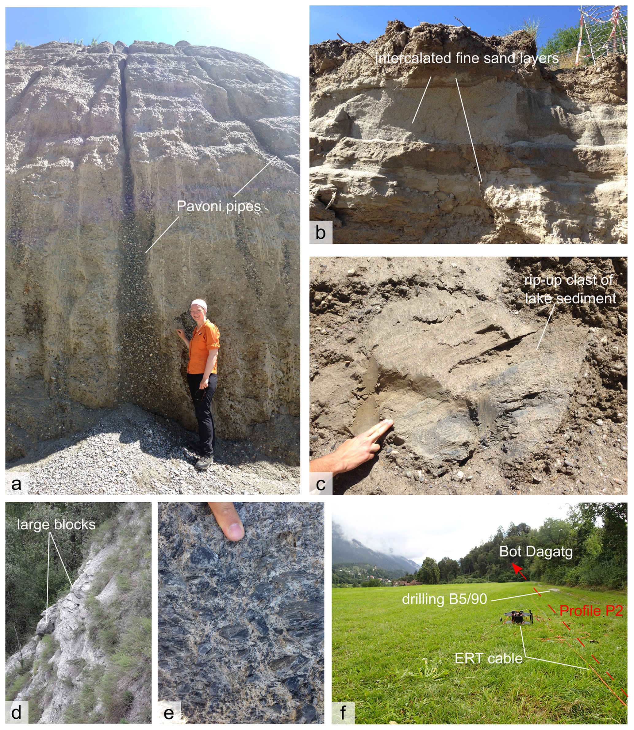
Figure 2Sedimentological field evidence of the Bonaduz Formation and toma hills used for ERT interpretation. (a) Unstratified, normally graded gravel deposits with fine-grained matrix and vertical Pavoni pipes in a gravel pit near Pardisla. (b) Stratified sands and silts at the top of the Bonaduz type locality at the gravel pit in Reichenau. (c) Large clasts within and on top of the Bonaduz Formation. (d) Outcrop with large rock slabs in toma near Pardisla. (e) Shattered rockslide material with fine-grained matrix at Tuma Casti (see Fig. 1 for location). (f) ERT profile P2 investigating Bot Dagatg rolls over several drilling sites, e.g. “B5/90”. Photo courtesy of M. Krautblatter.
In the European Alps, toma also occur at the rock avalanches at Fernpass (Prager et al., 2006), Almtal (Van Husen et al., 2007), Obernberg valley (Ostermann et al., 2012), Eibsee (Ostermann and Prager, 2016), and Lago di Braies (Ostermann et al., 2020). Deciphering the internal structure of the toma and of the Bonaduz Formation is assumed to be a key to understanding the complex emplacement of rock avalanche material after water-rich entrainment (Poschinger et al., 2006).
The present study addresses the following aspects and brings them in a chronological order of four phases: (i) geological events related to the Flims and Tamins rockslides (phases 1 and 2), (ii) the evolution of the above-described characteristic landforms of the toma and the deposit of the Bonaduz Formation (Phase 3), and (iii) the formation of outburst-flood deposits after rockslide-dam failure (Phase 4). With geoelectrical measurements and data from outcrops as well as publicly available drill logs, we provide insights into the toma and Bonaduz Formation up to ∼160 m depth, and give a more detailed view of the stratigraphic relationships around the Tamins and Flims rockslide deposits (Fig. 3).
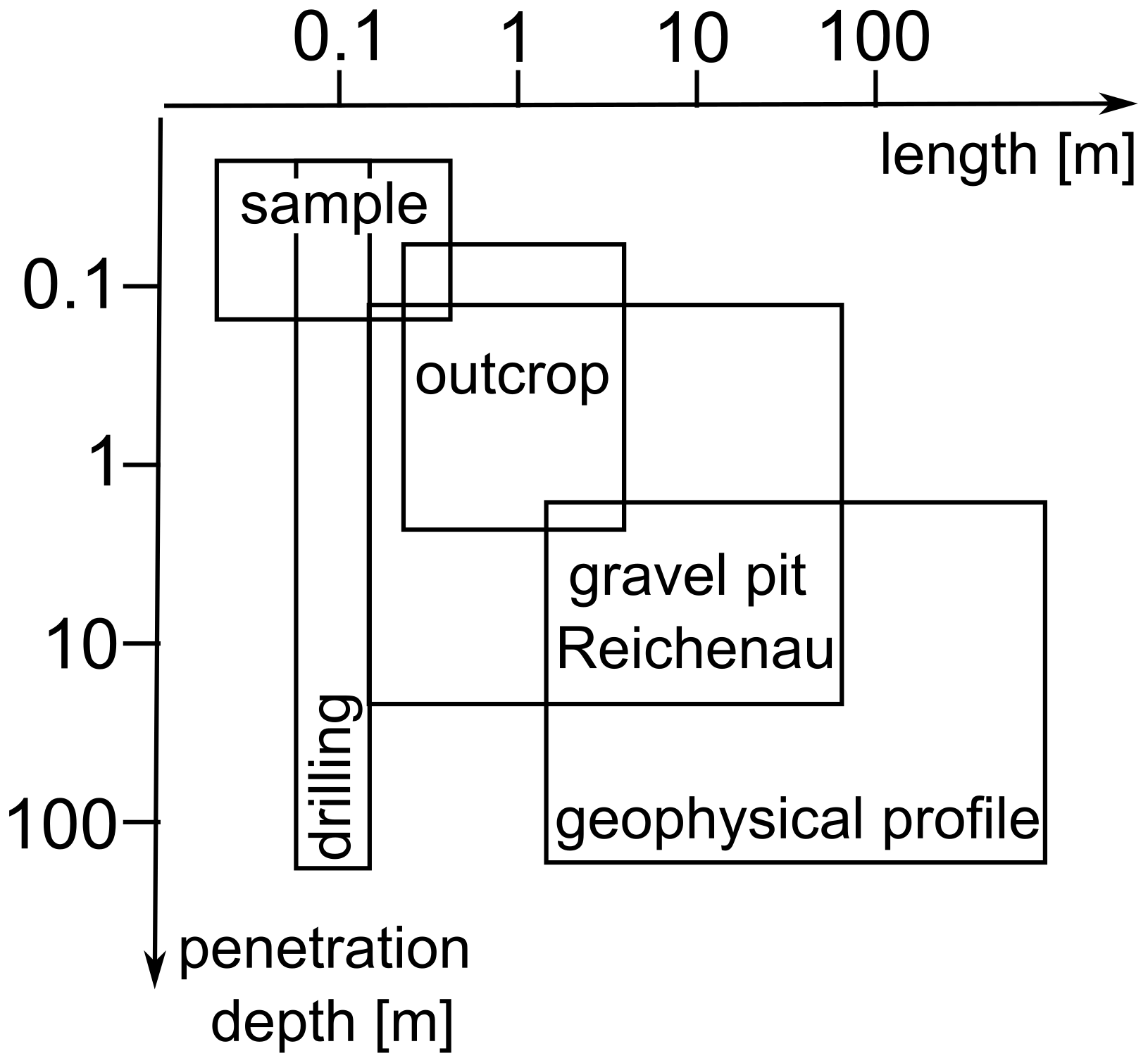
Figure 3Schematic plot highlighting the novelty of the geophysical results in the framework of a complementary method application.
Five electrical resistivity tomography (ERT) surveys were conducted in the area around the Tamins rockslide deposit (Fig. 1). We investigated the Bonaduz plain, its contact to the Ils Aults, and two hills – one to the west of Ils Aults (Bot Dagatg) and one to the east of Ils Aults (Tuma Padrusa). For the ERT measurements, an ABEM SAS 1000 Terrameter and four 100 m and four 200 m long electric cables with an electrode spacing of 5 and 10 m, respectively, were used. Roll-alongs, the stepwise allocation of cables from the back to the front of a transect, allowed an increased penetration depth over an extended distance covered with one individual transect (e.g. Profile P1 in Fig. 4a with one roll-along yielding a 1000 m profile length). A combination of Wenner and Schlumberger arrays was chosen to determine both vertical and horizontal resistivity changes. The local topography along the profiles was measured with an inclinometer. The sub-surface resistivity was modelled with RES2Dinv (ver. 3.5) and the determined topography was included in the models. The results were then interpreted based on our field observations in outcrops of the toma and Bonaduz Formation close to the profiles. Furthermore, we correlated the ERT models with sedimentological data from drill logs (Kanton Graubünden, 2022). These logs provide basic sedimentological information and interpretations. We re-evaluated these drilling results considering the findings in the ERT surveys and in the light of the most recent hypotheses about the Flims and Tamins rockslides. Eventually, we combined 11 drill logs and the four ERT profiles into a schematic cross-sectional overview of the local stratigraphy around the Tamins rockslide deposit (Fig. 5).
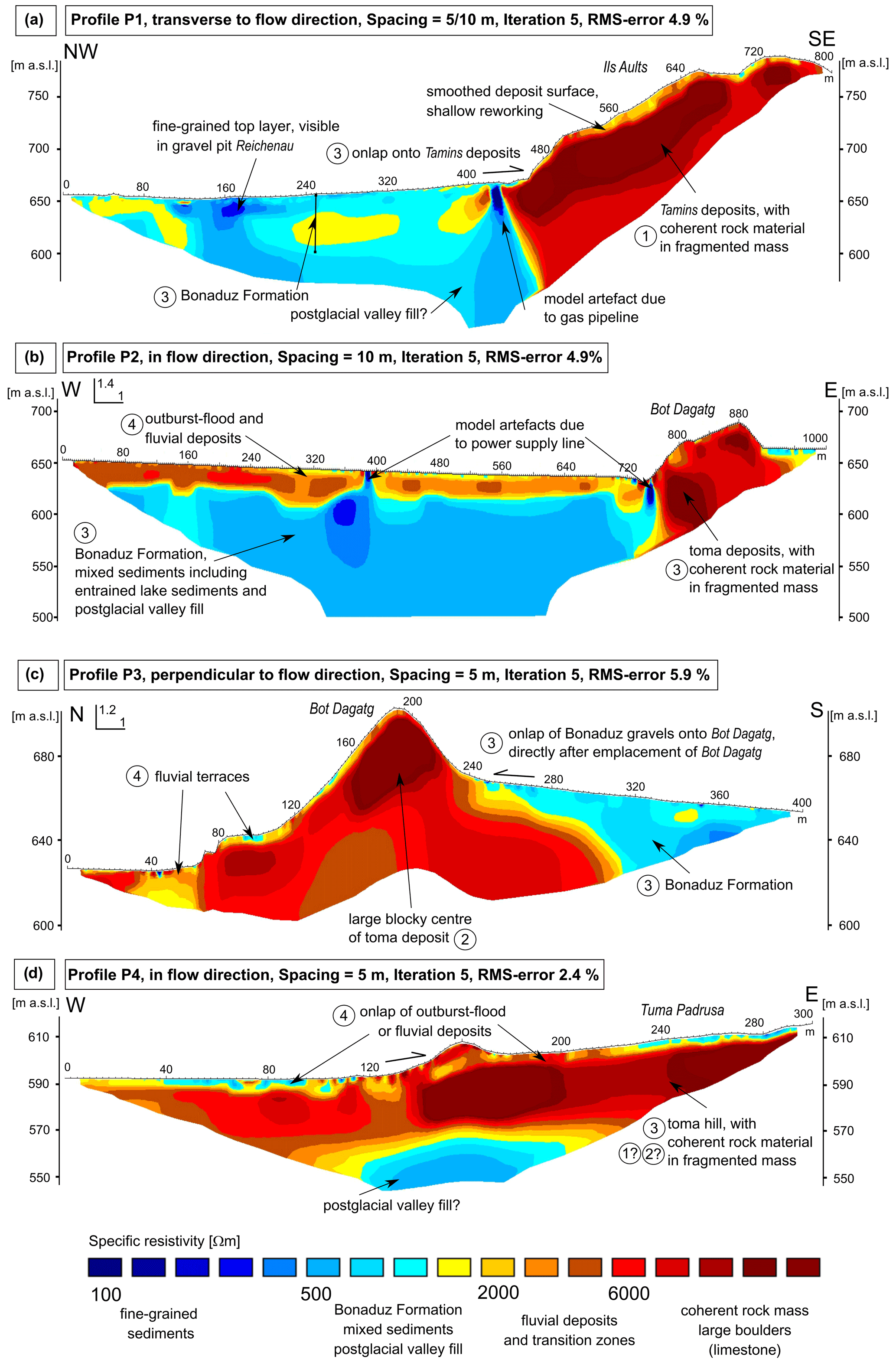
Figure 4ERT profiles P1–P4 indicating (a) the ∼60 m thick Bonaduz Formation (Phase 3) onlapping onto Ils Aults (Phase 1), (b) Bot Dagatg transported within the Bonaduz Formation (Phase 3), covered with some outburst-flood and/or fluvial deposits (Phase 4), (c) the onlapping Bonaduz Formation onto Bot Dagatg, and (d) Tuma Padrusa containing large slabs of (exposed) coherent rock material in a fragmented rock mass. The circled numbers correspond to the evolution phases 1–4.
Profile P1 (Fig. 4a) shows a NW–SE-oriented transect modelled from two surveys. One survey was conducted in a 500 m five-cable roll-along with 5 m electrode spacing; the second survey was conducted in an 800 m long four-cable survey with 10 m electrode spacing. The resistivity data of both transects were combined in order to provide a high spatial resolution in the upper 50–80 m below the surface and a high penetration depth of up to ∼160 m. The overall error of the resulting model is 4.9 %. The similarity in the MinMax models displays this small model variance well (Fig. S1 in the Supplement). It should be noted that a gas pipeline crosses perpendicular to the transect at metre 430 and unknown depth. Two main resistivity units can be distinguished. First, in the resistivity model, mixed sediments are detected down to 50–60 m penetration depth, indicated in yellow and light blue colour. The sediments of this resistivity unit are well accessible in the gravel pit of Reichenau (Fig. 1). A matrix-supported gravel unit with sandy to silty matrix is exposed in the pit. Overall, the unit is normally graded and unstratified and partially covered by sand and silt beds (Fig. 2b and c). The Reichenau pit represents the type locality of the Bonaduz Formation and here the unit is ∼60 m thick. We interpret these mixed sediments in the acquired model as the Bonaduz Formation, as the obtained resistivity and depth correlate well with the outcrop. In the middle of the transect, a crossing gas pipeline causes a model artefact. The resistivity patterns to both sides of the artefact appear to match and exemplify the geometry of a wedge. As such, this location is interpreted as the onlap of the Bonaduz Formation onto the rise of the Ils Aults that is visible at metres 400–450. The Ils Aults is regarded as part of the Tamins rockslide deposit (e.g. Calhoun and Clague, 2018) and is formed by coarse to blocky rock material, which causes the high resistivity values in the second unit, marked with red colour. A finer-grained sediment cover on top of the Ils Aults is indicated by mid-range resistivity values in yellow colour.
Bot Dagatg was investigated in two transects. Profile P2 (Fig. 4b) was obtained from a W–E-oriented transect across Bot Dagatg, which is the rise between metres 740 and 840 with an elevation of 690 m a.s.l. The survey reaches a maximum penetration depth of ∼160 m on a transect length of 1000 m. The overall error of the resistivity model is 4.9 % (MinMax models in Fig. S1). At metres 390 and 740, power supply lines cross perpendicular to the transect and cause artefacts. Profile P3 (Fig. 4c) was obtained from a N–S-oriented transect and shows a cross-cut section to Profile P2. This transect is 400 m long with a maximum penetration depth of ∼60 m. The overall error of the resistivity model is 5.9 % and shows the highest uncertainties at locations with rapid changes in resistivity (Fig. S1). In both models, the transition from low resistivity values (blue) to high values (red) occurs within a narrow zone. This quick transition in resistivity indicates a distinct change in material composition. We interpret these transition zones to indicate a sharp contact between the blocky core material of the toma and the surrounding Bonaduz Formation as well as other sedimentary valley fill. In profile P2, the Bonaduz Formation visibly laps onto the rise of Bot Dagatg from metres 240 to 320. We therefore suggest that the hill was transported within the finer-grained hyperconcentrated flow, as proposed by Calhoun and Clague (2018), and slightly overrun by the surrounding slurry after its halt, forming an onlap.
Profile P4 (Fig. 4d) was obtained in a 300 m long W–E-oriented survey that crossed Tuma Padrusa. This survey reaches a maximum penetration depth of 60 m. The overall model error is 2.8 %. In the centre of the toma, coarse, blocky material is indicated by high resistivity values. The hill is covered by a thin layer of mixed sediment, which seems to have overrun the coarse, coherent material in the centre, similar to Bot Dagatg. The onlapping and overrunning material probably decelerated during the uphill movement and was partially deposited “on the ramp”. We interpret the narrow transition zone from high to low resistivity values at ∼30–40 m penetration depth as the base of the toma above pre-existing sedimentary valley fill.
The ERT surveys conducted in the present study elucidate the formation and the stratigraphic relation of the Bonaduz Formation and the toma.

Figure 5Schematic cross section interpreted from the presented ERT surveys (indicated in grey). Drilling data indicated by black bars supported the interpretation of the depth. The projection of ERT profile P1 leads to a V-shaped body in the cross section. The circled numbers correspond to the evolution phases 1–4.
4.1 Characteristics of the Bonaduz Formation and implications for the Tamins–Flims timeline
Based on the information obtained from the ERT survey displayed in Profile P1 (Fig. 4a), the Bonaduz Formation has a mean thickness of ∼50–70 m at its type locality around Bonaduz. This measurement correlates well with the earlier sedimentological and geomorphological analyses by Calhoun et al. (2015) yielding up to 75 m and Calhoun and Clague (2018) stating a thickness of 65 m.
The ERT profile P1 (Fig. 4a) further show onlaps of the Bonaduz Formation onto the Ils Aults deposits. In the stratigraphical context, this onlap implies that the Ils Aults, regarded as a Tamins deposit, must have been formed before the Bonaduz Formation and further corroborates the hypotheses (Scheller, 1970; Abele, 1991; Poschinger et al., 2006) that (i) the Tamins rockslide occurred before the Flims rockslide, (ii) the Tamins deposits formed a dam and probably created Lake Bonaduz, and (iii) the Flims rockslide impacted Lake Bonaduz, thereby triggering a hyperconcentrated mass flow with gravel in suspension (Calhoun and Clague, 2018), known as the Bonaduz Formation. Similar results of mobilized substratum and water-rich entrainment after a rockslide impacting a lake are shown by Knapp et al. (2021) at the Eibsee rock avalanche.
4.2 Characteristics of the toma
The two investigated hills, Bot Dagatg and Tuma Padrusa, situated to the west and the east of Ils Aults, consist of limestone. Bot Dagatg is composed of Cretaceous limestone and Tuma Padrusa of Jurassic limestone (Quinten and Tros limestone). In the ERT profiles, they show more or less the same granular composition. Based on the model results presented in profiles P2–4 (Fig. 4b–d), we conclude that they most probably consist of large blocks of crushed and shattered rockslide material with capping gravels and fines. These observations are consistent with earlier results of, e.g., Arbenz and Staub (1910), Nabholz (1975), and Calhoun et al. (2015; outcrop picture of Tuma Padrusa in Fig. 155.4 therein).
However, the surrounding sediment of these two hills and the contacts therewith are different. The ERT models P2 and P3 (Fig. 4b and c) show that Bot Dagatg is framed by the Bonaduz Formation with an onlap on the southern flank. On the far side of the Tamins deposit, Tuma Padrusa is framed by less blocky but still coarse-grained material. The surrounding sediment also shows onlaps but clearly has a different composition compared to the Bonaduz Formation on the western side of Ils Aults. Probably, Tuma Padrusa resides in remobilized rockslide material and admixed Bonaduz Formation, a mixture that was formed during the failure of the dam that the Tamins deposit once formed (Calhoun and Clague, 2018). Both studied hills overlie the indiscernible and unaltered sedimentary valley fill at unknown depth (Fig. 5).
Furthermore, for Tuma Padrusa the ERT model indicates a mean thickness of ∼30–40 m. Compared to an elevation difference of ∼15 m between the surrounding plain and the toma surface in this section, the “root” of the toma lies 2–3 times deeper.
4.3 Toma transport and stratigraphy
Concerning the formation and stratigraphical position of the toma, our results confirm the hypothesis of a simultaneous transport within a highly fluidized mass movement. As suggested by Poschinger and Kippel (2009) and Calhoun and Clague (2018), it is plausible that pieces of the Flims rockslide were transported by a hyperconcentrated flow (Bonaduz Formation), which itself was caused by the rockslide. Our investigation showed that Bot Dagatg is mainly composed of an isolated rock slab that is embedded in and onlapped by the Bonaduz Formation, which supports this theory of their synchronous formation and deposition. Likewise, the blocky core of Tuma Padrusa was most probably transported within the sediment that it is embedded in.
Similar observations of toma transport within highly fluidized mass movements were reported from the Fernpass site (Prager et al., 2006) and analogue models (Paguican et al., 2014). Prager et al. (2006) interpreted the onlapping sediments as post-rockslide fluvial clasts. In the Flims context, we suggest a syn-depositional or late-depositional emplacement of the onlapping unit, clearly linked in time to the main event and the Bonaduz Formation. We postulate that the coarse centre of a toma hill comes to stop first due to strong internal cohesive forces and resulting high friction to the surrounding sediment, so that the finer-grained slurry can overtop in flow direction, forming an onlap. It is possible that the toma core is slightly moved and maybe rotated during the overflow of and interaction with the finer sediment (Dufresne and Geertsema, 2020). Still, it remains unclear, whether the top deposits revealed in the outcrops and the ERT models could also have been deposited during later outburst floods of Lake Ilanz (Schneider et al., 2004; Poschinger et al., 2006).
4.4 Other toma origin
Concerning the toma around Domat/Ems on the far side of Ils Aults, Calhoun and Clague (2018) hypothesize that these are pieces of the Tamins rockslide deposit, which was torn apart during a catastrophic dam breakage. Our ERT results of Tuma Padrusa (Fig. 4d) substantiate the possibility that the rock slab was transported eastwards, indicated by the onlap and the overrunning sediment coming from the west. Unfortunately, the internal structure and content of Tuma Padrusa do not allow for a clear separation between a Flims origin and remobilized Tamins material. But it is interesting to note that we observe very coarse rock material at the front and also at the back of Tuma Padrusa. This fact might give an indication of a subsurficial connection to neighbouring hills in the close vicinity and would support the theory of the torn apart Tamins deposits, but there is need for more field research here.
The onlap of the Bonaduz Formation onto the Ils Aults constitutes novel field evidence in the debate about the timeline of geological events around Flims (Fig. 6). The following hypotheses are supported by this evidence: (i) the Tamins rockslide (Phase 1) occurred before the Flims rockslide (Phase 2), (ii) the Tamins deposits formed a dam and probably created Lake Bonaduz (Phase 1), and (iii) the Flims rockslide impacted Lake Bonaduz (Phase 2), thereby triggering push waves and a hyperconcentrated mass flow with gravel in suspension. The Bonaduz Formation between the Flims and Tamins deposits has an average thickness of ∼50–70 m.
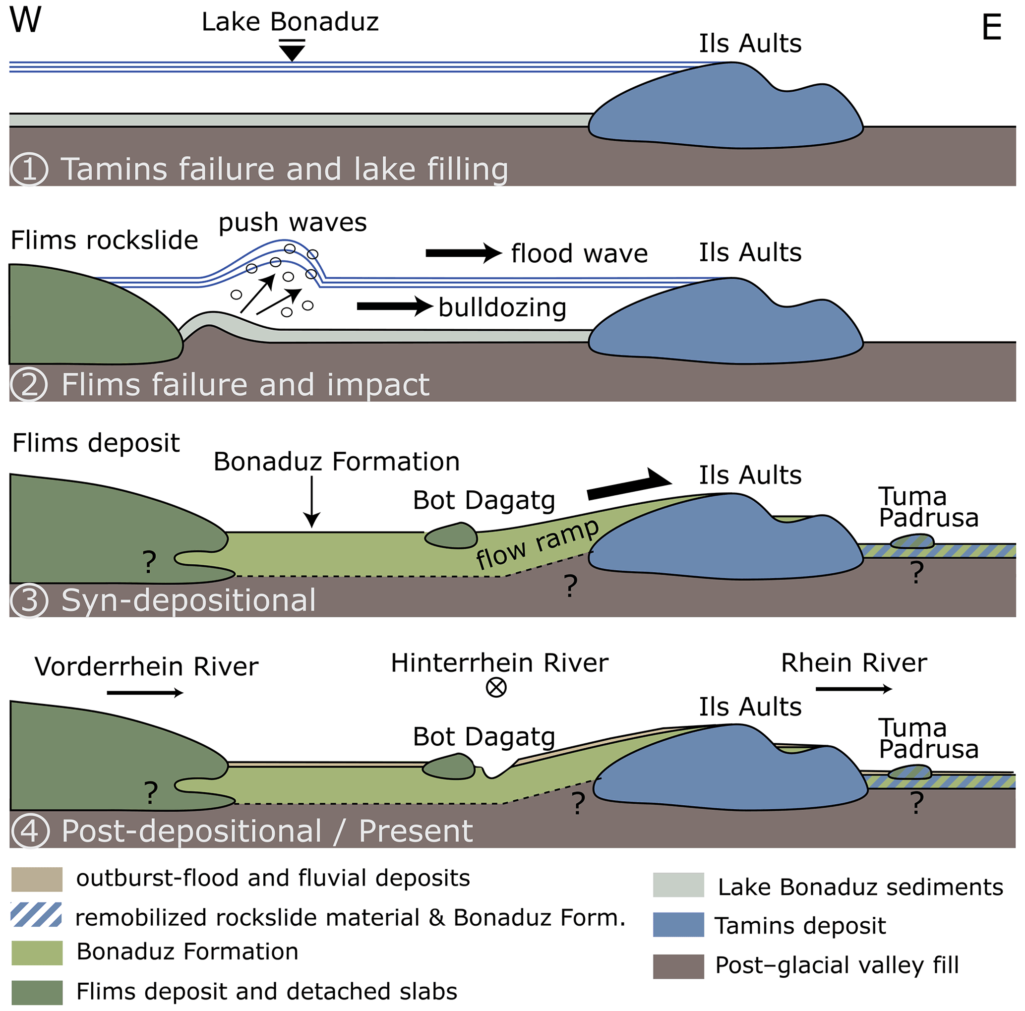
Figure 6Timeline of geological events displaying the following hypotheses: (Phase 1) Lake Bonaduz dammed by the Ils Aults after Tamins rockslide; (Phase 2) push waves and bulldozing after impact of Flims rockslide; (Phase 3) simultaneous evolution of the Bonaduz Formation, transporting toma; (Phase 4) outburst-flood and recent fluvial deposits partially cover the Bonaduz plain. Schematic sketch without scale.
The stratigraphic position of the toma is related to the Flims rockslide (Phase 2) and the Bonaduz Formation (Phase 3). Some of the hills could also be related to the previous Tamins rockslide (Phase 1). The internal structure shows a core of coherent, blocky rock material, embedded in a fragmented rock mass. During the transport, an agglomeration of mixed sediments with a smaller grain size (gravel–sand mixture) drifts and overrides the toma core, building an onlap in flow direction and causing a smoothened surface. The toma transport is regarded as simultaneous for the coherent rock slabs in the toma core, whereas the onlapping and overriding slurry are assumed to be emplaced rather late-depositionally, since the deep-rooted toma core has already stopped due to internal cohesion and frictional forces opposing the movement. Afterwards, outburst-flood and fluvial deposits covered parts of the Bonaduz plain (Phase 4).
This study provides other scientists with a better understanding of the complex history of sedimentation and erosion in the Flims area and further contributes to the process understanding of sediment transport after water-rich entrainment in rock avalanches.
Additional ERT profiles (MinMax plots) are published as Fig. S1 online along with the article.
The supplement related to this article is available online at: https://doi.org/10.5194/esurf-10-1185-2022-supplement.
SK and MK designed the experiments, and SK and MS carried them out. SK and MS performed the simulations. SK prepared the paper with contributions from all co-authors.
At least one of the (co-)authors is a member of the editorial board of Earth Surface Dynamics. The peer-review process was guided by an independent editor, and the authors also have no other competing interests to declare.
Publisher's note: Copernicus Publications remains neutral with regard to jurisdictional claims in published maps and institutional affiliations.
We are grateful to Andreas von Poschinger, who guided and advised us during our field campaigns in Flims. We also thank John Clague for deep discussions and his help with fieldwork around Ils Aults. Joel Achenbach and Verena Stammberger assisted field and laboratory work. We further thank the reviewers for their suggestions and remarks, which improved our paper. This research was supported through a PhD scholarship awarded to Sibylle Knapp by the German National Academic Foundation.
This work was supported by the German Research Foundation (DFG) and the Technical University of Munich (TUM) in the framework of the Open Access Publishing Program.
This paper was edited by Sebastien Castelltort and reviewed by Marc Ostermann and O. Adrian Pfiffner.
Aaron, J., Wolter, A., Loew, S., and Volken, S.: Understanding Failure and Runout Mechanisms of the Flims Rockslide/Rock Avalanche, Front. Earth Sci., 8, 224, 2020.
Abele, G.: Bergsturze in den Alpen – Ihre Verbreitung, Morphologie und Folgeerscheinungen, Wiss. Alpenvereinshefte, 25, 247, 1974.
Abele, G.: Durch Bergstürze mobilisierte Muren und durch Muren transportierte Bergsturzmassen, Jahresber. Österr. Geogr. Ges., 1989/90, 33–39, 1991.
Arbenz, P. and Staub, W.: Die Wurzelregion der helvetischen Decken im Hinterrheingebiet und die Überschiebung der Bündnerschiefer südlich von Bonaduz, Vjschr. Naturforsch. Ges. Zurich, 55, 23–62, 1910.
Calhoun, N., Poschinger, A., Clague, J., Giardino, M., Masera, D., and Perotti, L.: New Pieces to the Flims-Tamins Rockslide Puzzle, in: Engineering Geology for Society and Territory, vol. 2, Springer, 899–903, https://doi.org/10.1007/978-3-319-09057-3_155, 2015.
Calhoun, N. C. and Clague, J. J.: Distinguishing between debris flows and hyperconcentrated flows: an example from the eastern Swiss Alps, Earth Surf. Proc. Land., 43, 1280–1294, 2018.
Deplazes, G., Anselmetti, F. S., and Hajdas, I.: Lake sediments deposited on the Flims rockslide mass: the key to date the largest mass movement of the Alps, Terra Nova, 19, 252–258, 2007.
Dufresne, A. and Geertsema, M.: Rock slide–debris avalanches: flow transformation and hummock formation, examples from British Columbia, Landslides, 17, 15–32, 2020.
Heim, A.: Bergsturz und Menschenleben, in: Separatdruck aus der Vierteljahrsschrift 77/BB20, Naturforschende Gesellschaft Zürich, Zurich, 1932.
Ivy-Ochs, S., Poschinger, A., Synal, H.-A., and Maisch, M.: Surface exposure dating of the Flims landslide, Graubünden, Switzerland, Geomorphology, 103, 104–112, 2009.
Kanton Graubünden: Bohrungen und Grundwasserbeobachtungen: https://edit.geo.gr.ch/theme/Grundwasser, last access: 17 March 2022.
Knapp, S., Mamot, P., Lempe, B., and Krautblatter, M.: Impact of an 0.2 km3 Rock Avalanche on Lake Eibsee (Bavarian Alps, Germany) – Part I: Reconstruction of the paleolake and Effects of the Impact, Earth Surf. Proc. Land., 46, 296–306, 2021.
Nabholz, W. K.: Geologischer Überblick über die Sackung des mittleren Lugnez und über das Bergsturzgebiet Ilanz-Flims-Reichenau-Domleschg., Bull. Ver. Schweiz, Petroleum-Geol. und -ingenieure, 42, 38–54, 1975.
Ostermann, M. and Prager, C.: Field Trip 12: Rock slope failures shaping the landscape in the Loisach-, Inn- and Ötz Valley region (Tyrol, Austria), in: Geo.Alp, 13, 257–276, 23 September–1 October 2016.
Ostermann, M., Sanders, D., Ivy-Ochs, S., Alfimov, V., Rockenschaub, M., and Römer, A.: Early Holocene (8.6 ka) rock avalanche deposits, Obernberg valley (Eastern Alps): Landform interpretation and kinematics of rapid mass movement, Geomorphology, 171, 83–93, 2012.
Ostermann, M., Ivy-Ochs, S., Ruegenberg, F., and Vockenhuber, C.: Characteristics and Dating of the rock avalanche at Pragser Wildsee/Lago di Braies (Dolomites, Italy), Alpine and Mediterranean Quaternary, 33, 183–189, 2020.
Paguican, E., de Vries, B. v. W., and Lagmay, A.: Hummocks: how they form and how they evolve in rockslide-debris avalanches, Landslides, 11, 67–80, 2014.
Pavoni, N.: Über die Entstehung der Kiesmassen im Bergsturzgebiet von Bonaduz-Reichenau (Graubünden), Eclogae Geol. Helv., 61, 494–500, 1968.
Pfiffner, O.-A., Schlunegger, F., and Buiter, S.: The Swiss Alps and their peripheral foreland basin: Stratigraphic response to deep crustal processes, Tectonics, 21, 3-1–3-16, 2002.
Piperoff, C.: Geologie des Calanda mit einer geologischen Karte in 1:50 000, Beiträge zur Geologischen Karte der Schweiz, In Kommission bei Schmid & Francke, Bern, 1897.
Pollet, N. and Schneider, J. L. M.: Dynamic disintegration processes accompanying transport of the Holocene Flims sturzstrom (Swiss Alps), Earth Planet. Sc. Lett., 221, 433–448, 2004.
Poschinger, A.: Weitere Erkenntnisse und weitere Fragen zum Flimser Bergsturz, Swiss Bulletin for Applied Geology, 11, 35–43, 2006.
Poschinger, A. and Haas, U.: Der Flimser Bergsturz, doch ein warmzeitliches Ereignis?, Bulletin für angewandte Geologie, 2, 35–46, 1997.
Poschinger, A. and Kippel, T.: Alluvial deposits liquefied by the Flims rock slide, Geomorphology, 103, 50–56, 2009.
Poschinger, A. and Ruegg, T.: Die Churer Tomahügel, ein besonderes Zeugnis der Landschaftsgenese, Jahresbericht der Naturforschenden Gesellschaft Graubünden, 93–100, 2012.
Poschinger, A. V., Wassmer, P., and Maisch, M.: The Flims rockslide: history of interpretation and new insights, in: Landslides from massive rock slope failure, Springer, 329–356, https://doi.org/10.1007/978-1-4020-4037-5_18, 2006.
Prager, C., Krainer, K., Seidl, V., and Chwatal, W.: Spatial features of Holocene sturzstrom-deposits inferred from subsurface investigations (Fernpass rockslide, Tyrol, Austria), Geo. Alp, 3, 147–166, 2006.
Scheller, E.: Geophysikalische Untersuchungen zum Problem des Taminser Bergsturzes, No. 4560, Dissertation ETH Zürich, Zürich, https://doi.org/10.3929/ethz-a-000090312, 1970.
Schneider, J.-L., Pollet, N., Chapron, E., Wessels, M., and Wassmer, P.: Signature of Rhine Valley sturzstrom dam failures in Holocene sediments of Lake Constance, Germany, Sediment. Geol., 169, 75–91, 2004.
van Husen, D., Ivy-Ochs, S., and Alfimov, V.: Mechanism and age of late glacial landslides in the Calcareous Alps; the Almtal, Upper Austria, Austrian J. Earth Sc., 100, 114–126, 2007.
Wyss, R. and Wiederkehr, M.: Blatt 1215 Thusis, Geologischer Atlas Schweiz 1:25 000, Erläuterungen, Bundesamt für Landestopografie swisstopo, p. 108, ISBN 978-3-302-40094-5, 2017.