the Creative Commons Attribution 4.0 License.
the Creative Commons Attribution 4.0 License.
 | 24 Jun 2025
The glacial paleolandscapes of Southern Africa: the legacy of the Late Paleozoic Ice Age
Pierre Dietrich
François Guillocheau
Guilhem A. Douillet
Neil P. Griffis
Guillaume Baby
Daniel P. Le Héron
Laurie Barrier
Maximilien Mathian
Isabel P. Montañez
Cécile Robin
Thomas Gyomlai
Christoph Kettler
Axel Hofmann
The modern relief of Southern Africa is characterized by stepped plateaus bordered by escarpments. This morphology is thought to result from stepwise uplift and ensuing continental-scale erosion of the region as it rode over Africa's mantle superplume following the breakup of Gondwana, i.e., since the mid-Mesozoic. We show in this contribution that the modern topography over large parts of Southern Africa bears glacial relief inherited from the Late Paleozoic Ice Age (LPIA) that occurred between 370 and 280 Myr ago and during which Gondwana – which included Southern Africa – was covered in thick ice masses. Southern Africa hosts vast (up to 106 km2) and thick (up to 5 km) sedimentary basins ranging from the Carboniferous, represented by glaciogenic sediments tied to the LPIA, to the Jurassic–Cretaceous. These basins are separated by intervening regions largely underlain by Archean to Paleoproterozoic cratonic areas that correspond to paleohighlands that preserve much of the morphology that existed when sedimentary basins formed, particularly glacial landforms. In this contribution, we review published field and remote data and provide a new large-scale interpretation of the geomorphology of these paleohighlands of Southern Africa. Our foremost finding is that over Southern Africa vast surfaces are exhumed glacial landscapes tied to the LPIA. These glacial landscapes manifest in the form of centimeter-scale striated pavements; meter-scale fields of roches moutonnées, whalebacks, and crag and tails, narrow gorges cut into mountain ranges; and kilometer-scale glacial erosion surfaces and large U-shaped valleys, overdeepenings, fjords, and troughs up to 200 km in length. These forms are frequently found covered or filled with coarse-grained, glaciogenic sediments (frontal and lateral moraines, grounding zone wedges, IRD-bearing muds, etc.), whose distribution largely follows the pattern of glacial forms. Importantly, these glacial forms still today control many modern aspects of the surficial processes, such as glacial valleys that funnel the modern drainage network of some transects of the main rivers of Southern Africa.
To explain how the glacial landscape has survived for such an extended period, we argue that its preservation and modern exposure may be attributed to burial under substantial layers of Karoo sediments and lavas for approximately 120 to 170 million years, followed by its exhumation since the middle Mesozoic, linked to the uplift of Southern Africa. Owing to strong erodibility contrasts between resistant Precambrian bedrock and softer sedimentary infill, the glacial landscapes have been exhumed and re-exposed. This remarkable preservation allows us to reconstruct the paleogeography of Southern Africa in the aftermath of the LPIA, consisting of highlands over which ice masses nucleated and from which they flowed through the escarpments and toward lowlands that now correspond to sedimentary basins.
Moreover, we propose that in many instances, glacial erosion processes have superimposed an older, non-glacial land system whose original form is still expressed in the modern geomorphology of Southern Africa. Notably, some escarpments that delineate high-standing plateaus from coastal plains could be surficial expressions of crustal-scale faults whose offset likely operated before the LPIA and on which glacial processes are marked in the form of striae. Additionally, some hill or mountain ranges may have already existed during LPIA times, potentially reflecting remnants of Pan-African orogenic belts. Whether these features were later reactivated or persisted unchanged since that time is uncertain, but they were shaped by glacial erosion. We further propose that a network of pre-existing alluvial valleys could have existed before the LPIA, possibly formed during an extended period of exhumation and erosion in Southern Africa. These valleys may have later facilitated ice flow from highlands to lowlands, although the extent and configuration of such features remain speculative.
The exhumed pre-LPIA landforms may in some cases be taken for pediments, pediplains, and pedivalleys and interpreted as recording the topographic evolution of Southern Africa after the dislocation of Gondwana during the Mesozoic. Some glacial valleys are also taken for rift structures. We therefore emphasize the need of considering the legacy of LPIA geomorphology when assessing the topographic evolution of Southern African and its resulting modern aspect, as well as inferences about climate changes and tectonic processes.
- Article
(14679 KB) - Full-text XML
- BibTeX
- EndNote


Glacial erosion processes profoundly shape the relief of glaciated continents and continental shelves. For instance, areal scouring, U-shaped valleys and fjords, overdeepenings, and cross-shelf troughs that dominate the current morphology of northern North America, Greenland, Scandinavia, and Antarctica largely result from glacial erosion occasioned by the expansion and demise of Cenozoic and Quaternary ice sheets (see contributions in this special issue; Sugden and Denton, 2004; Steer et al., 2012; Dowdeswell et al., 2016; Paxman et al., 2018; Couette et al., 2022; Vérité et al., 2021, 2023, 2024). Southern Africa was also covered in continental-scale ice masses, twice over the Phanerozoic during icehouse climate periods, on the occasion of the Ordovician (445–443 Myr ago) and late Paleozoic ice ages (ca. 370–280 Myr ago, Ghienne et al., 2007; Le Heron et al., 2009; Montañez, 2021). However, considering these ice ages happened hundreds of millions of years ago, it is generally thought that their morphological expression has long been erased. Therefore, long-term evolution of the Southern African topography and the resultant modern-day landscapes are viewed as originating from erosion–sedimentation processes and lithospheric uplifts in response to tectonic and non-glacial climate forcings over the Cenozoic and the Mesozoic (Burke and Gunnell, 2008; Feakins and Demenocal, 2010; Kamp and Owen, 2013; Paul, 2021). The high-standing plateaus, pediments, and coastal plains separated by intervening escarpments and valleys that characterize the peculiar morphology of Southern African are indeed interpreted as mostly originating from Atlantic rifting and continental breakup processes (Dauteuil et al., 2013; Salomon et al., 2015). Such phenomena are denudation, fluvial erosion, and scarp retreat paced by anorogenic uplifts tied to the polyphase activity of the African mantle plume since 130 Ma (Moucha and Forte, 2011; Braun et al., 2014; Goudie and Viles, 2015; Mvondo Owono et al., 2016; Braun, 2018; Guillocheau et al., 2018b; Margirier et al., 2019; Baby et al., 2018b, 2020). Yet, many regions of Southern Africa bear glacial erosion surfaces, U-shaped valleys, and meter- to kilometer-scale landforms that happen to be glacially scoured paleorelief tied to the Late Paleozoic Ice Age (Lister, 1987; Visser, 1987a; Andrews et al., 2019; Dietrich and Hofmann, 2019; Le Heron et al., 2019, 2022, 2024; Dietrich et al., 2021), suggesting that the contribution of glacial erosion processes in shaping the modern morphology of Southern Africa has largely been underestimated. Indeed, although the morphologic footprint of glacial erosion processes in tectonically active terrains is generally considered largely transient at geological timescales, prone to be rapidly erased over a few million years (Prasicek et al., 2015), glacial landforms may survive over long geological periods if buried and fossilized under sediments in tectonically quiescent or subsiding areas.
Here we test the idea that some of the current relief and landscapes of Southern Africa are inherited from late Paleozoic glacial erosion processes. For doing so, we present new field and remote sensing geomorphic observations along with a compilation of existing studies and geological and GIS-based mapping, which we integrate with sedimentologic studies to test the origin of landscapes scattered across Southern Africa and apprise their origin (Fig. 1). This combined approach revealed the presence of vast (103–105 km2) relief carved by glacial processes during the Late Paleozoic Ice Age, which sometimes superimposed and re-exploited older relief. Glacial relief is in fact mostly encountered on Archean to Paleoproterozoic terrains forming the three cratons situated in Southern Africa – the Kaapvaal, Zimbabwe, and Congo cratons. Our study therefore revives the concept of ancestral exposed land surfaces over Southern African cratons (the “Gondwana surface” of King, 1949a, b, 1982; see also Twidale, 2003; Doucouré and de Wit, 2003; Guillocheau et al., 2018b). We also address the preservation of these relict glacial landscapes – how they escaped being erased for over hundreds of millions of years – through an early burial and geologically recent re-exposure. Based on these findings, we also propose a paleogeographic reconstruction of Southern Africa in the immediate aftermath of the LPIA. We discuss the heritage of pre-LPIA non-glacial morphological features and surficial expression of tectonic structures preserved, reactivated, or enhanced through glacial erosion and whose imprint is still expressed in the landscapes of Southern Africa, discussing the potential polyphased nature of the pre-Karoo surface. We also emphasize the need to consider ancient glacial erosion morphological features as a major component of the modern-day Southern African landscapes and emphasize the different forms of the sub-Dwyka glacial erosion surfaces and their use to reconstruct Mesozoic and Cenozoic topographic evolution of the African surfaces and to infer post-LPIA base level variations and tectonic processes (Gilchrist et al., 1994; Rouby et al., 2009; Kamp and Owen, 2013; Mvondo Owono et al., 2016; Baby et al., 2018a, b, 2020; Grimaud et al., 2018).
2.1 General physiography
We refer here to Southern Africa as a ca. 4 000 000 km2 region shared by South Africa, Namibia, Botswana, Zimbabwe, Mozambique, Lesotho, and Eswatini (Fig. 1a). The morphology of this region is characterized by high-standing plateaus lying above 1000 m a.s.l. and frequently above 2000 m a.s.l. (Fig. 1a). These plateaus are surrounded by steep escarpments leading downward to stepped plateaus (planation surfaces) of lower elevation and ultimately to the coastal plains (see Braun et al., 2014; Guillocheau et al., 2018b; Baby et al., 2018a, b, 2020, and references therein for details). The escarpments are dissected by valleys focusing the river drainage network, such as the Orange–Vaal–Fish and Ugab and Kunene rivers flowing to the west in the Atlantic, Zambezi and Limpopo to the east in the Indian Ocean, and endorheic system at the center (Baby et al., 2020).
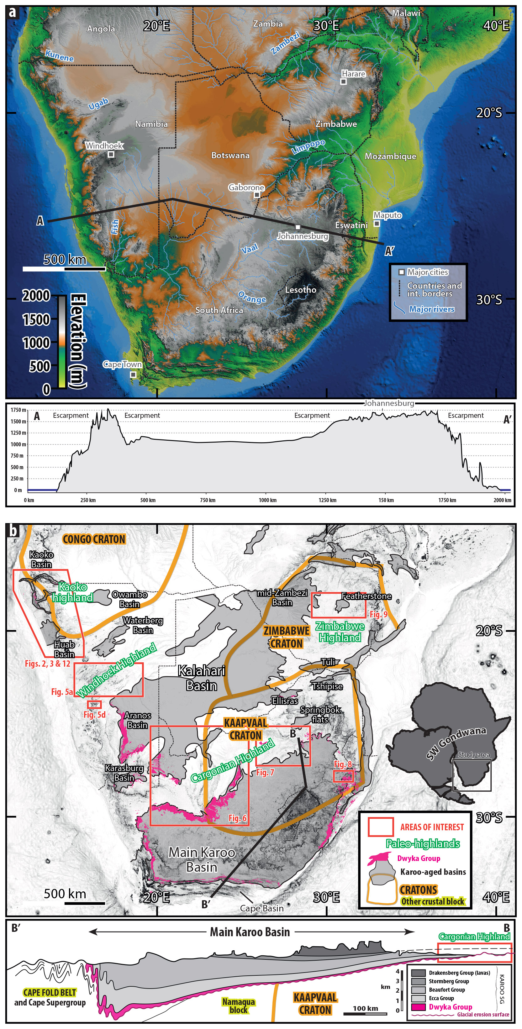
Figure 1(a) Modern relief of Southern Africa shown by a digital elevation model (DEM) from the Shuttle Radar Topography Mission (https://www.earthdata.nasa.gov/data/instruments/srtm, last access: 16 June 2025) along with major river networks, international borders, and main cities. The transect highlights the high-standing plateaus. (b) Southern Africa with regions of interest discussed in the text shown by red frame. The Archean to Paleoproterozoic Congo, Kaapvaal, and Zimbabwe cratons are evidenced by thick orange lines, and the Karoo basins are represented by gray shaded area. The glaciogenic Dwyka Group is represented by pink color. The four paleohighlands discussed in the text are evidenced in green. Inset map shows western Gondwana formed by Africa and South America. The transect displays the thickness and sedimentary succession of the Main Karoo Basin (MKB) of South Africa, with the glaciogenic Dwyka Group in pink, the glacial erosion surface (wavy pink line) at the base of the Karoo Supergroup, and the underlying basement structure (cratons vs. accreted terranes). Transect modified after Johnson et al. (1997) and Karoo basins after Catuneanu et al. (1998).
2.2 Geological setting and pre-LPIA events
Southern Africa is rooted by three Archean to Paleoproterozoic cratons – the Kaapvaal, Zimbabwe, and Congo cratons (Fig. 1b) – that amalgamated via younger terranes during orogenic events throughout the Proterozoic (Tankard et al., 2009; Begg et al., 2009; Torsvik and Cocks, 2016). The assembly of Gondwana, which Southern Africa was part of, occurred through the Pan-African orogeny, at the end of the Proterozoic and early Paleozoic. In Southern Africa, this orogeny involved the Congo and Kalahari cratons, with the latter comprising the already-coalesced Kaapvaal and Zimbabwe cratons, to form the Damara branch of the Pan-African orogeny. The collision between the Rio de la Plata and Congo cratons formed the Kaoko branch, whilst the Gariep and Saldania belts reflect the Kalahari and Rio de la Plata closure, between ca. 580 and 510 Ma (Begg et al., 2009; Lehmann et al., 2016; Goscombe et al., 2017). This period of acute tectonic activity and its aftermath is reflected by a continuous exhumation since at least 600 Ma over orogenic terrains (Krob et al., 2020) and since 1 Ga over the cratons (Baughman and Flowers, 2020) until ca. 300 Ma, as expressed by thermochronology data. Localized subsidence marked the Cape region from the Cambrian to the lower Carboniferous with deposition of the Cape Supergroup, ca. 3000 m thick, deposited likely due to rifting and lithospheric deflection due to subduction-driven mantle flow (Fig. 1b, Theron, 1972; Streel and Theron, 1999; Shone and Booth, 2005; Thamm and Johnson, 2006; Tankard et al., 2009; Penn-Clarke and Theron, 2020). The Cape Basin was then deformed and inverted during the Cape orogeny and today crops out over ca. 90 000 km2 in the Cape Fold Belt at the Southern tip of South Africa. This orogeny, the only orogenic event that affected the rest of Southern Africa throughout the Phanerozoic, initiated during the Permian–Triassic and was induced by the subduction of the Panthalassic Ocean (Hansma et al., 2016).
From the late Paleozoic (Carboniferous) to early Mesozoic, large regions of Southern Africa over which erosion previously prevailed were then subsiding, which promoted the deposition of thick sediment piles in large sedimentary basins named “Karoo basins”. These basins lie over the basement and the Cape Basin and occupy vast areas, 103–106 km2, and are named after the Main Karoo Basin (MKB) of South Africa, the thickest (5–6 km), largest (ca. 700 000 km2), and most studied of these basins, investigated since at least the mid-19th century (see Linol and de Wit, 2016). Together, the Karoo basins of Southern Africa cover an area of ca. 1 600 000 km2, among which ca. 800 000 km2 are subcrop, mostly covered by younger sediments of the Kalahari Desert (Fig. 1b, Catuneanu et al., 2005; Haddon, 2005). The volcano–sedimentary pile that forms these Karoo basins – the Karoo Supergroup – can be up to 5 km thick and ranges in age from Carboniferous to Jurassic (in South Africa and Zimbabwe) or Cretaceous (in northern Namibia) (Stratten, 1977; Smith, 1990; Smith et al., 1993; Johnson et al., 1996; Catuneanu et al., 2005; Milani and De Wit, 2008; Franchi et al., 2021). Depositional environments within the Karoo Supergroup range, from base to top, from glacial (the Dwyka Group), marine (Ecca and Beaufort groups), continental and aeolian (Stormberg Group), and finally subaerial lava outpouring (Drakensberg and Etendeka groups) (Fig. 1b; Johnson et al., 1996). Two subsidence mechanisms are proposed for the Main Karoo Basin of South Africa. Johnson et al. (1997), Catuneanu (2004), Catuneanu et al. (2005), and Isbell et al. (2008) postulated isostatic and flexural deflection tied to the Cape orogeny. However, as the orogeny likely initiated around the Permian–Triassic boundary, ca. 250 Myr ago, the date at which the MKB started to function as a foreland, it has been proposed that the MKB originated from a lithospheric deflection pulled down by subduction-driven mantle flow – dynamic subsidence (Pysklywec and Mitrovica, 1999; Pysklywec and Quintas, 1999; Tankard et al., 2009). This dynamic subsidence was first marked by foundering of rigid crustal blocks along pre-existing crustal structures such as faults and then by long-wavelength subsidence (see details in Tankard et al., 2009). During the late Mesozoic and Cenozoic, after the dislocation of Gondwana responsible for the emission of the Drakensberg lavas, anorogenic uplift related to Indian and Atlantic Ocean breakups and post-rift mantle dynamics led to the inversion of these sedimentary basins and widespread, continental-scale erosion and planation, as detailed in Sect. 2.4 (Veevers et al., 1994; Lithgow-Bertelloni and Silver, 1998; Moulin et al., 2010; Braun et al., 2014; Linol and Wit, 2016; Braun, 2018; Guillocheau et al., 2018b).
2.3 The record of the ice ages
During the Neoproterozoic, four ice ages developed over Southern Africa, among which are the two Snowball Earth episodes, and all left behind a wealth of sedimentary archives (Hoffmann et al., 2021). Pan-African tectonic processes strongly overprinted these deposits in numerous regions, leaving little geomorphic remnants of the glacial episodes preserved over Southern Africa. Later, during the Paleozoic, Southern Africa as part of SW Gondwana experienced two distinct and extensive glaciations, the short-lived Late Ordovician episode (ca. 443–445 Ma, Deynoux and Ghienne, 2004; Ghienne et al., 2007; Le Heron and Dowdeswell) and the protracted LPIA (ca. 370–260 Ma, Isbell et al., 2012, 2021; Montañez and Poulsen, 2013; Griffis et al., 2019a, b, 2021, 2023; Montañez, 2021). Southern Africa preserved these two glacial episodes in the form of glaciogenic sedimentary successions within the Cape and Karoo supergroups, respectively, and/or relict glacial erosion features carved on the bedrock.
2.3.1 The Late Ordovician glacial episode
The Ordovician glacial episode is recorded within the Cape Supergroup in the form of a 5–20 m thick layer of diamictite, corresponding to an unsorted mixture of fine- and coarse-grained sediments, named the Pakhuis Pass Formation, and interpreted as having been deposited under a flowing ice sheet (Thamm and Johnson, 2006; Blignault and Theron, 2010). The Pakhuis Pass Formation is well known for topping the iconic Table Mountain overhanging the city of Cape Town. A single outcrop displays a striated glacial pavement at the Pakhuis Pass of the Cederberg region (Deynoux and Ghienne, 2004). High-amplitude (50 m) folds are present below the Pakhuis Pass Formation and are linked to the activity of a glacier flowing over waterlain soft sediments (Backeberg and Rowe, 2009; Blignault and Theron, 2010, 2017; Rowe and Backeberg, 2011). No major relict glacial erosion landforms are associated with this glacial episode, and the sedimentary record of the Ordovician glaciation is spatially restricted to the Cape Fold Belt in South Africa (Thamm and Johnson, 2006; Ghienne et al., 2007; Fourie et al., 2011; Meadows and Compton, 2015; Davies et al., 2020).
2.3.2 The Late Paleozoic Ice Age (LPIA)
The lowermost sedimentary unit of the Karoo Supergroup – directly lying on the basement, Carboniferous–Permian in age, and of a glaciogenic origin – deposited by ice sheets during the LPIA is the Dwyka Group (the pink layer within Fig. 1b; Visser, 1990; Johnson et al., 1996; Cairncross, 2001; Catuneanu et al., 2005; Griffis et al., 2018, 2019a, 2021). The Dwyka Group is extensively present in Southern Africa and crops out or has been identified through drilling in all Karoo basins (Fig. 1b, Smith, 1984; Catuneanu et al., 2005). The Dwyka Group within the MKB is named after the Dwyka River crossing the Cape Mountain in the Western Cape Province (Dunn, 1886; Pfaffl and Dullo, 2023), and its equivalents within other Karoo basins have different, locally sourced names such as Dukwi, Waterkloof, Gibeon, Malogong, or Tshidzi (Haughton, 1963; Smith, 1984; Johnson et al., 1997; Modie, 2002, 2008; Catuneanu et al., 2005; Bordy, 2018). For sake of clarity, we will refer to it as the Dwyka Group throughout the paper, independently of the basin considered. The Dwyka Group within the MKB and the Aranos Basin of Namibia is typically several hundreds of meters thick but has been found as thin as a few centimeters in some other Karoo basins (Visser, 1987a, b, 1997; Isbell et al., 2008; Stollhofen et al., 2008; Miller, 2011; Dietrich and Hofmann, 2019). The lithologies and facies encountered within the Dwyka Group are very diverse but commonly consist of diamictites, clast-bearing mudstones, and conglomerates, interpreted as representing various glacial-related depositional environments, and have been the focus of a plethora of studies (Martin and Schalk, 1959; Crowell and Frakes, 1972; Stratten, 1977; Visser, 1982, 1983, 1987a, b, 1994, 1997; Visser and Kingsley, 1982; Visser and Hall, 1985; Visser and Loock, 1987; Smith et al., 1993; Von Brunn, 1994; Veevers et al., 1994; Johnson et al., 1996, 2006; Von Brunn, 1996; Haldorsen et al., 2001; Werner and Lorenz, 2006; Fielding et al., 2008; Isbell et al., 2008; López-Gamundí and Buatois, 2010; Miller, 2011; Linol and Wit, 2016; Dietrich and Hofmann, 2019; Dietrich et al., 2019, 2021; Menozzo da Rosa et al., 2023; Fedorchuk et al., 2023; Fernandes et al., 2023). Glacial striae, grooves, and lineations carved by sliding glaciers within soft sediments (and on hard bedrock surfaces; see below) are common features of the Dwyka Group (e.g., Le Heron et al., 2022, 2024; Dietrich and Hofmann, 2019; Le Heron et al., 2019). Interestingly, these coarse-grained deposits associated with glacial pavements have long been attributed a glacial origin (Sutherland, 1868, 1870; Dunn, 1886, 1898; Molengraaf, 1898; Cloos, 1915; Wagner, 1915; Du Toit, 1921; Pfaffl and Dullo, 2023). Also, the glaciogenic Dwyka Group and its South American equivalent, the Itararé Group on the other side of the Atlantic Ocean in Southern Brazil, largely led South African geologist Alexander L. Du Toit (1878–1948) and German geologist Henno Martin (1910–1998) to be early supporters of Wegener's theory of continental drift (Du Toit, 1921, 1927, 1933, 1937; Martin and Schalk, 1959; Martin, 1961, 1973b, a; see also Haughton, 1949; Milani and De Wit, 2008; Miller, 2011; Linol and de Wit, 2016; Pfaffl and Dullo, 2023).
The Karoo basins are separated by cratonic regions over which no or very thin Dwyka and Karoo deposits lie. Wedging out and onlap of Karoo strata against these regions, depositional environments of the Dwyka Group pointing toward a continental ice sheet, and the presence of high glacial relief together indicate that these areas correspond to highlands that already existed during the deposition of the Dwyka Group, hereafter referred to as paleohighlands (Fig. 1b, Visser, 1985, 1987a, b, 1997; Smith et al., 1993; Catuneanu et al., 1998, 2005; Isbell et al., 2008). Four paleohighlands exist over Southern Africa – the Kaoko, Windhoek, Cargonian, and Zimbabwe – underlain by resistant Archean to Paleoproterozoic basement rocks that form craton and/or shield areas (Fig. 1b). It is over these paleohighlands or on their rims marked by escarpments that most of the glacial landforms and erosion surfaces are observed. These morphological features encompass a range of landform types and shapes ranging from small-scale (10−2–0 m: striae and grooves) to intermediate-scale (100–3 m: roches moutonnées, cirques, whalebacks, and crag and tails) to large-scale (104–6 m: fjords, troughs, overdeepenings, and area scouring) glacial forms and land surfaces (Benn and Evans, 2010; Dietrich et al., 2019, 2021). These glacial erosion surfaces have been named “ancestral glacial pre-Karoo peneplain” (Wellington, 1937), “pre-Dwyka topography” (Du Toit, 1954; von Gottberg, 1970) or “pre-Karoo surface” (Lister, 1987). It is indeed generally assumed that they were carved during the LPIA, immediately before the deposition of the Karoo Supergroup that started with the glaciogenic Dwyka Group, although their potential pre-LPIA origin has been recognized previously and is discussed below (Sect. 5.1). These glacial erosion forms are the main focus of the present contribution for which a review and new constraints are provided below (Sect. 3 and Figs. 2 to 8).
As no major orogenic event affected the region after the deposition of the Karoo Supergroup (Torsvik and Cocks, 2016), except for the localized Permian–Triassic Cape orogeny, glacial paleorelief has preserved their original shape and orientation, and Dwyka strata lie mostly horizontally. Although, there is a slight and local tilt of the Karoo strata in regions which are attributed to vertical motions of the lithosphere induced by the activity of the African superplume or isostatic processes linked to the Atlantic passive margin.
2.4 Post-Gondwana-breakup history of the Southern African Plateau
Following the breakup of Gondwana, which is defined by the opening of the Indian and Atlantic oceans in the Early Jurassic and Early Cretaceous (Frizon De Lamotte et al., 2015; Thompson et al., 2019; Roche et al., 2021; Roche and Ringenbach, 2022), lithospheric movements were mostly vertical in response to the African mantle superplume. Pulses in the activity of this plume led to episodes of swelling and uplift of Southern Africa. This stepwise uplift induced multiple phases (polycyclic) of erosion and planation of the interior of the continent, including the inversion of the Cape and Karoo basins, retreat of the passive margin escarpments, and export of sediments thus produced to the continental margins (e.g., Partridge and Maud, 1987, 2000; van der Beek et al., 2002; Braun, 2010, 2018; Braun et al., 2014; Baby et al., 2018a, b, 2020; Guillocheau et al., 2018b; Stanley et al., 2021). By quantifying and budgeting onshore erosion (through geomorphology and thermochronometry) and offshore sediment accumulation (through seismic stratigraphy), sediment fluxes were reconstructed, which together with other inferences, e.g., assessment of sediment routing and characterization of kimberlite pipes, allowed us to reconstruct the post-Gondwana-breakup history of the Southern African Plateau, as summarized hereafter.
During the Lower Cretaceous, erosion of the Southern African Plateau was spatially restricted, and erosion products were funneled eastward through a proto-Orange River system in the south and eastward through the proto-Zambezi–Limpopo drainage in the north (De Wit, 1999; Moore and Larkin, 2001; Baby, 2017; Ponte, 2018; Baby et al., 2020; Stanley et al., 2021).
A first period of accelerated denudation of the margins of the plateau followed, at ∼ 150–120 Ma, tied to continental breakup and post-rift erosion of the rift shoulders, as indicated by thermochronometric data (e.g., Gallagher and Brown, 1999; Brown et al., 2002; Tinker et al., 2008b; Kounov et al., 2009, 2013; Stanley et al., 2013, 2015, 2021; Wildman et al., 2016, 2015; Green et al., 2017). A second pulse of denudation took place at ∼ 100–70 Ma and coincides with acceleration of offshore sediment flux (Walford et al., 2005; Tinker et al., 2008a; Rouby et al., 2009; Guillocheau et al., 2012; Said et al., 2015; Baby et al., 2020). This second pulse of denudation likely resulted from the tilting of the plateau to the west that steepened the slopes across the sub-continent and enhanced a widespread and fast erosion response, notably of the passive margin escarpments (Braun et al., 2014; Baby et al., 2018b; Ding et al., 2019; Stanley et al., 2021). In this context, Wellington (1955) and Braun et al. (2014) highlighted the importance of the erodibility contrast between the soft Karoo sedimentary cover and the underlying harder basement.
By the end of the Cretaceous, the western side of the plateau was uplifted, as suggested by offshore stratigraphic observations (Aizawa et al., 2000; Paton et al., 2008; Baby et al., 2018b) and onshore kimberlite pipe ages distribution (Jelsma et al., 2004; Braun et al., 2014; Hanson et al., 2009; Partridge, 1998). This could have resulted in a symmetrical configuration of the Southern African Plateau (similar to the modern one), which would have strongly reduced the erosion potential by reducing the slope of a large portion of the sub-continent interior (Braun et al., 2014; Baby et al., 2020; Stanley et al., 2021). This scenario is supported by a drop in offshore sediment flux (Baby et al., 2020), the preservation of crater-lake sediments in ∼ 75–65 Ma kimberlite pipes (Moore and Verwoerd, 1985; Scholtz, 1985; Smith, 1986), and the onset of the Kalahari Basin aggradation (Haddon and McCarthy, 2005).
Thermochronometric data and offshore sediment fluxes point to limited erosion of the plateau during the Cenozoic (Stanley et al., 2021, and references therein). Recent low-temperature thermochronological data show that Cenozoic erosion focused along the present-day river valleys rather than being broadly distributed as during the middle Cretaceous (Stanley and Flowers, 2023).
Although each pulse of uplift and therefore erosion is thought to be recorded as a planation surface, it has been suggested that very ancient, possibly Jurassic or older, land surfaces are preserved across Southern Africa, older than the initiation of uplift of Southern Africa and predating the dislocation of Gondwana, and called the “Gondwana surface” (Du Toit, 1933; King, 1949a, b, 1982; Doucouré and de Wit, 2003).
In the following section, we describe and review the geomorphology and sedimentary infill of glacial landforms preserved across the paleohighlands of Namibia (the Kaoko and Windhoek highlands, Sect. 3.1 and 3.2), South Africa and Botswana (the Cargonian Highland, Sect. 3.3), and Zimbabwe (the Zimbabwe Highland, Sect. 3.4) (Fig. 1). This is done by combining novel field and aerial/satellite observations, a digital elevation model (DEM) from the Shuttle Radar Topography Mission (SRTM, https://www.earthdata.nasa.gov/data/instruments/srtm, last access: 16 June 2025), and geological map analysis as well as an assessment of existing literature. We provide morphostratigraphic transects evidencing the presence of glacially carved relief and the presence of glaciogenic Dwyka sediments based on geological maps and digital elevation models (Figs. 3 to 9).
Based on these data, we provide a description and an interpretation of the glacial paleorelief and the glaciogenic sedimentary rocks hosted within glacial relief wherever present. Possible pre-glacial origin (surficial expression of tectonic structures enhanced by glacial erosion or older non-glacial erosional forms later re-exploited by glacial erosion) is discussed in Sect. 5.1. For each study site, we present evidence for glacial processes (plain pink line on transects in Figs. 2 to 9) or, for suspected glacial landscapes, we provide supporting data and discuss their potential glacial origin (dotted pink line on transects in Figs. 2 to 9). For these latter cases, additional field-based examinations targeting striated pavements or other evidence for glacial activity would be required to confirm their glaciogenic nature. Erosion and resulting landforms of mountain glaciers that existed locally during the Quaternary will not be considered in this study (Hall and Meiklejohn, 2011; Knight and Grab, 2015).
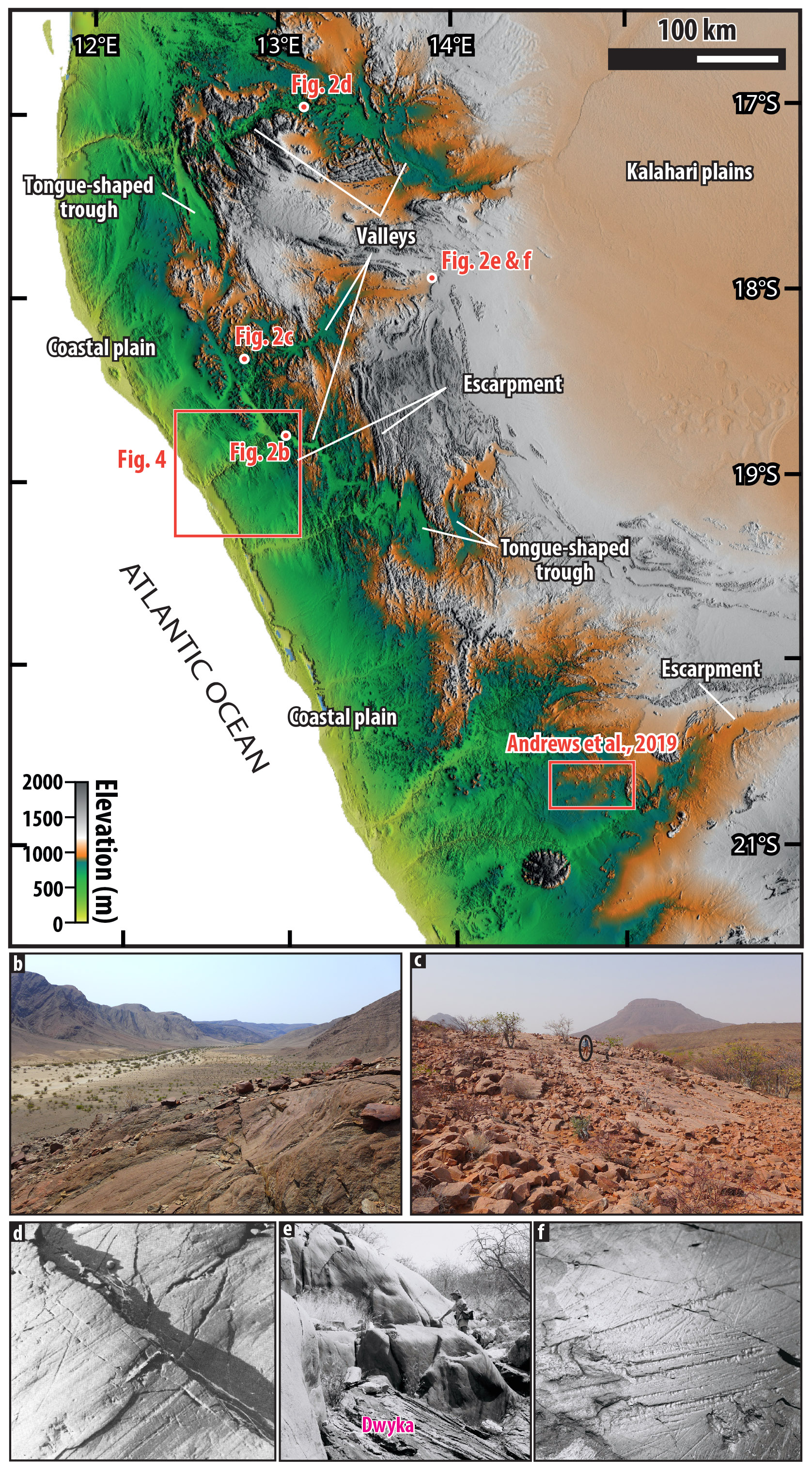
Figure 2(a) DEM of the Kaoko region of northern Namibia, corresponding to the Kaoko paleohighland. The escarpments, valleys, and tongue-shaped troughs discussed in the text are arrowed. The location of the pictures is also indicated. See Fig. 1b for location. (b) The Gomatum Valley corresponds to a fjord carved during the LPIA, later sealed and exhumed in recent times. See Dietrich et al. (2021) for further details. Valley is ca. 2.5 km wide and 550 m deep. (c) A field of roches moutonnées and whalebacks characterized by glacial striae and grooves and polished floors covered in places by boulder pavement, evidencing a westward ice movement. Circled geologist for scale; see Le Heron et al. (2024) for details. Photo credit: Daniel P. Le Heron. (d) Striated floor in the Kunene Valley; plucking at the joint shows ice movement from east to west. Width of photo in foreground: ca. 50 cm. Picture from Martin (1961). (e) Glacially polished walls; geologist Henno Martin for scale. (f) Floor in NE Kaoko; width of photo in foreground: ca. 20 cm. Pictures (e) and (f) taken by K. E. L. Schalk in 1956; see Miller (2011). Digital elevation model (DEM) from the Shuttle Radar Topography Mission (https://www.earthdata.nasa.gov/data/instruments/srtm, last access: 16 June 2025).
3.1 The Kaoko Highland
The Kaoko region of NW Namibia is formed by a plateau that stands at ∼ 1000 m a.s.l. and is located at the boundary between the Congo Craton and the Kaoko branch of the Pan-African orogenic belt (Figs. 1 and 2). This plateau is bordered to the west by a succession of stair-like escarpments (that may correspond to surficial expression of crustal-scale faults; see below) leading to the Atlantic Ocean through a gently inclined, ∼ 50 km wide coastal plain. Eastward, the plateau leads toward the low relief of the Kalahari plains. On the northern half of the Kaoko region, a network of E–W-oriented valleys, in which modern rivers flow toward the Atlantic, deeply dissect both the plateau and the escarpments. Tongue-shaped troughs, N–S-oriented, are also incised within the highland or at the feet of the escarpments. These troughs either connect with the river network or are endorheic. The southern half of the Kaoko region is characterized by a plateau separated on its western side from the coastal plain by a single escarpment.
In the northern half of the Kaoko Highland, a network of E–W-oriented valleys between the Kunene River to the north and the Hoanib River to the south has been interpreted by Dietrich et al. (2021) as an exhumed glacial landscape (Fig. 3). These valleys are U-shaped, and their floors and subvertical flanks commonly display abundant small-scale, hard-bed glacial erosion features such as striae, grooves, whalebacks, and roches moutonnées (Fig. 2; see also Fedorchuk et al., 2023). Paleovalleys in Angola that cut through the escarpment may also correspond to glacial valleys (Moragas et al., 2023). In places, these glacial erosion features are covered with remnants of glaciogenic sediments of the Dwyka Group (Fig. 3), including frontal and lateral moraines and glaciomarine sediments such as ice-rafted debris scattered in shales (Fig. 2; see also Martin and Schalk, 1959; Dietrich et al., 2021; Menozzo da Rosa et al., 2023; and Fig. 16.1 in Miller, 2011). These glaciogenic sediments are typically found abutting against the valley walls (Fig. 3; Le Heron et al., 2024). Based on the relict glaciogenic forms and associated sedimentary rocks, these modern valleys were interpreted as exhumed paleofjords whose modern U-shaped profiles reflects their original glacial morphologies (Dietrich et al., 2021; see also Martin, 1953, 1961, 1968, 1973b, 1981; Martin and Schalk, 1959). As the bottoms of the valleys are frequently covered in recent alluvium, however, it is difficult to observe potential overdeepenings. Moreover, Dietrich et al. (2021) demonstrated that the Purros escarpment separating the high-standing plateau to the coastal plain already existed by the LPIA as indicated by glacial striae found on the escarpments (Fig. 2). In this same region, at the downstream end of some of the aforementioned U-shaped valleys are deep and encased bedrock canyons, such as the Purros and Khowarib canyons. Geological maps indicate scattered glaciogenic sedimentary rocks within these canyons (Fig. 4). We therefore suggest that these canyons forming the downstream continuation of exhumed glacial valleys may correspond to gorges similar to those characterizing the base of Quaternary glacial valleys found in almost all terrains that experienced repeated Quaternary glaciations (e.g., Lajeunesse, 2014; Livingstone et al., 2017). Such an interpretation, however, awaits confirmation by further sedimentological and geomorphological characterization. Moreover, the N–S-oriented tongue-shaped troughs, such as the Omarumba–Omutirapo, the Sesfontein and Warmquelle at the head of the glacially carved Hoanib Valley, and the Otjinjange (Figs. 2 and 3) were interpreted as glacial cirques by Martin (1953, 1961, 1968; see also Hoffman et al., 2021, pp. 105–106). These troughs are endorheic or connect to the river systems through narrow ravines encased within mountain reliefs, which might suggest glacial overdeepening and subglacial gorge (Dürst Stucki et al., 2012). Here though, no glaciogenic sediments or morphological features have so far been described or reported, hindering a definitive interpretation.
To summarize, the presence of glacial erosion features within the valleys and on the escarpments indicates this relief already existed by LPIA times and was occupied, and then at least partly carved, by glacial ice, although their older origin is discussed below. It remains unclear, however, whether the interfluves between the glacial valleys are glacial in origin as no trace of glacial erosion has been reported so far, as they might have been lowered down by erosion in post-LPIA times. In both cases, however, this network of U-shaped glacial valleys encased within low-relief, high-elevation plateaus would point toward a selective linear erosion sensu Benn and Evans (2010). As discussed below, the selective linear erosion may have followed already existing non-glacial erosional landforms such as alluvial valleys and pediments or weaknesses in the underlying basement geology.
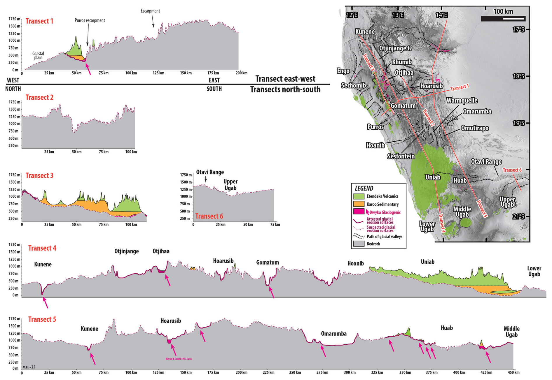
Figure 3Geological map indicating the Karoo Supergroup and morphostratigraphic transects across the Kaoko Highland, highlighting the morphology of the Kunene, Kaoko, and Huab–Ugab regions and the associated glacial valleys and troughs. Etendeka lavas are represented in green, non-glaciogenic Karoo sediments in yellow, and the glaciogenic Dwyka Group in pink, or indicated by pink arrows. Dashed black lines on the map represent outlines of exhumed glacial reliefs and valleys; solid purple lines on morphostratigraphic transects represent glacial surfaces, and dashed purple lines represent suspected glacial surfaces. Bedrock in gray indicates substrate older than the Karoo Supergroup. Note that this coloration is consistently used throughout the paper. See Fig. 1b for location. Digital elevation model (DEM) from the Shuttle Radar Topography Mission (https://www.earthdata.nasa.gov/data/instruments/srtm, last access: 16 June 2025).
Further south, in the Huab–Uniab regions (Figs. 2 and 3), outliers of Karoo sediments and Cretaceous Etendeka lavas topping the Karoo succession form the western part of the plateau and rest on highly uneven basement rocks dipping southward (transects 4 and 5 in Fig. 3). This volcano–sedimentary pile, reaching 1000 m in maximum thickness to the south, thins toward the north: the basal sedimentary units are present only in the deepest part of these basins, formed by the Huab and Lower Ugab to the south (Mabbutt, 1951). The pile of sedimentary rocks wedges out northward to the Uniab Basin where Etendeka lava rests directly on the bedrock. Glaciogenic sedimentary rocks are observed resting directly on the bedrock in the Huab Basin (transect 5 in Fig. 3), whereas none are mapped at the interface between the lavas and the bedrock further north (at the border between the Uniab and Hoanib basins, transect 5 in Fig. 3). Andrews et al. (2019) argued that profiled, elongated hills of the middle Ugab Basin are glacial megalineations and megawhalebacks indicative of paleo-ice streams (Fig. 2; see discussions in Le Heron et al., 2022, 2024). Based on these observations, we suggest that this uneven bedrock topography covered by glaciogenic sediments corresponds to an exhumed glaciogenic relief. Given its dimension, i.e., at least 150 km wide and 1000 m deep, and the presence of geomorphic evidence for ice streams, we interpreted this glacial topographic depression that forms the Huab and Lower Ugab basins (Figs. 2 and 3) as a cross-shelf trough, as its dimensions match those of Quaternary ones, as reviewed by Batchelor and Dowdeswell (2014). The deepest parts of this large glacially carved depression were filled by sediments of the Lower Karoo Supergroup (Holzförster et al., 2000), which probably promoted preservation of the glaciogenic sediments and landforms. Shallower parts to the north remained protruding until the outpouring of the Etendeka lavas some 165 Myr after the glaciation (Dodd et al., 2015; Gomes and Vasconselos, 2021), which likely eroded and erased all evidence for glacial activity.
3.2 The Windhoek Highland
The Windhoek Highland lies at the center of Namibia and almost reaches 2000 m above sea level and is composed of Neoproterozoic age rocks which formed during the Damara orogeny (Fig. 5; Begg et al., 2009). Numerous valleys dissect and radiate outward from the Windhoek Highland. Most of these valleys have been interpreted or inferred as exhumed glacial valleys by Martin (1968, 1981; see also Miller, 2011). However, the only firm evidence for a glacial origin is the N–S-oriented Black Nossob River valley which has a U-shaped cross-profile, 7 km wide and 30 m deep, at the bottom of which are remnants of glaciogenic sediments preserved, as indicated by geological maps (transect 2 in Fig. 5). The other river valleys dissecting the Windhoek Highland; the upper and lower Swakop and its tributary; the Okahandja–Windhoek and the Kurikaub; the southward-flowing Skaap, Usip, and Nausgamab; and the westward-flowing Kuiseb have also been interpreted by Martin (1975, 1981) as glaciogenic. Although these valleys have conspicuous U-shaped cross-profile (Fig. 5c), no glaciogenic sediments or morphologies have been mapped or described in the literature or observed during our own fieldwork within the thalweg of these valleys. A Dwyka outcrop has been described in the vicinity of the Nausgamab Valley (Fig. 5, Faupel, 1974), which would witness at least local glacial processes; we however did not locate these deposits during our own field campaign. The Okahandja–Usip is sometimes interpreted as a graben tied to Mesozoic–Cenozoic extensive processes (the Windhoek graben, Schneider, 2004; Waren et al., 2023), whereas the other valleys seem to follow grain of the underlying basement: N–S-oriented valleys follow a network of faults whilst NE–SW-oriented valleys follow lithological boundaries. Further field studies are therefore required to confirm a glacial origin of the network of valleys dissecting the Windhoek Highland.
Further south, Korn and Martin (1959) and Martin (1953, 1961) indicate that the encased U-shaped, E–W-oriented Tsondab Valley that crosscuts the Naukluft Mountains is a glacial valley, as remnants of Dwyka sediments occur within the valley thalweg (Fig. 5d, e and f). The geological map also indicates glaciogenic sediments on the interfluve of the valley whose form would therefore indicate selective linear glacial erosion (Fig. 5d). Therefore, in this case, the valley and its interfluves where glacial sediments are preserved correspond to a glacial relief. The very name “Naukluft” means “narrow gorge” in Namibian German, which unintentionally reflects the presence of the glacial valley.
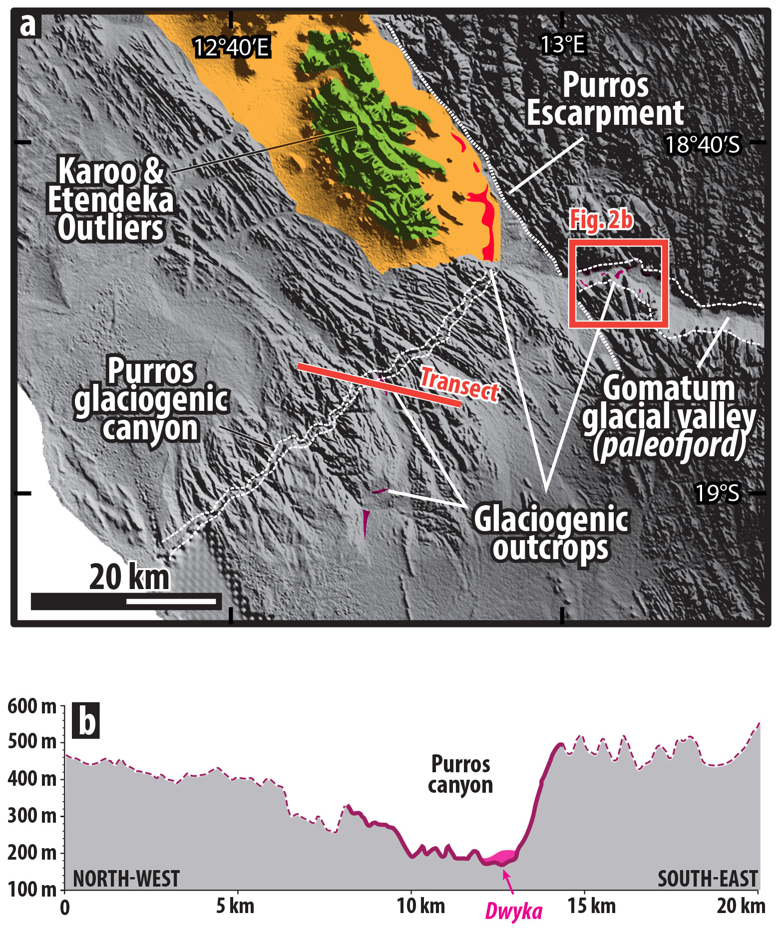
Figure 4(a) DEM of the western coastal Kaoko region and (b) morphostratigraphic transect. In the Purros canyon are remnants of glaciogenic sediments, and therefore the canyon is tentatively interpreted here as a relict glacial landform. See Fig. 2 for location. Digital elevation model (DEM) from the Shuttle Radar Topography Mission (https://www.earthdata.nasa.gov/data/instruments/srtm, last access: 16 June 2025).
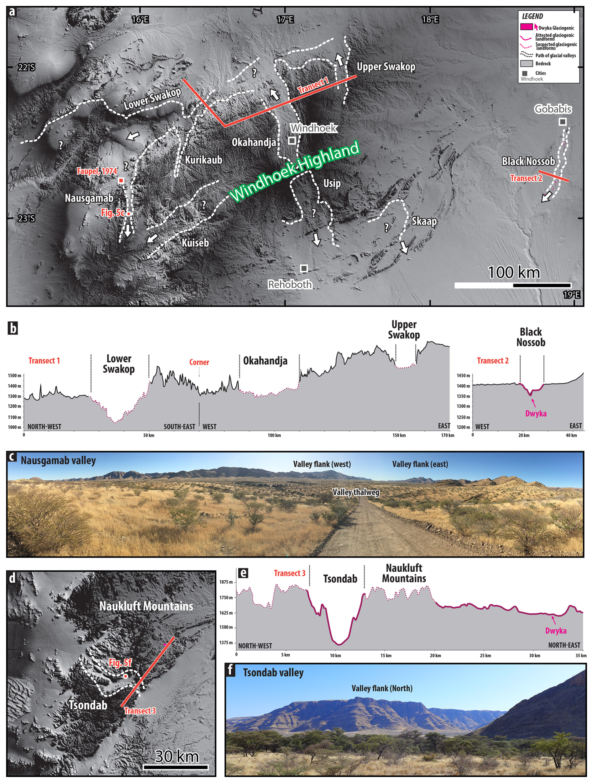
Figure 5(a) DEM of the Windhoek Highland (central Namibia), from the Shuttle Radar Topography Mission (https://www.earthdata.nasa.gov/data/instruments/srtm, last access: 16 June 2025); (b) their morphostratigraphic transects; and (c) mosaic picture of the U-shaped Nausgamab Valley interpreted by Martin (1961) as a potential glacial valley (see also Miller, 2011). Faupel (1974) reported glaciogenic sediments in the vicinity of this valley; (d) DEM of the Naukluft mountain crosscut by the U-shaped Tsondab Valley interpreted by Korn and Martin (1959) and Martin (1961) as a glacial valley. (e) Morphostratigraphic transect and (f) picture of the Tsondab Valley. See Fig. 1b for location. Photo credit: Pierre Dietrich.
3.3 The Cargonian Highland
In South Africa, between the MKB and the Kalahari Basin (Fig. 1), large areas of the Kaapvaal Craton, with the basement formed by Archean to Paleoproterozoic rocks, correspond to exhumed glacial landscapes (Figs. 6, 7, and 8). Portions of the Ghaap Plateau and the Kaap–Orange River valleys (Fig. 6) as well as the Highveld, Witbank, Bushveld, and Mooi–Harts areas in the Johannesburg–Pretoria region and the Vredefort Dome (Fig. 7) are part of the extensive Cargonian paleohighland. The term “Cargonian” stands for the contraction between Carboniferous and Gondwanian and was coined by Visser (1987a). The Buffalo–Tugela River valleys, at the southeasternmost edge of the craton, preserve widespread glacial landscapes (Fig. 8). Over these areas, vast erosion surfaces, U-shaped valleys, fjords, inlets, embayments, troughs, and canyons were carved by direct glacial action (Visser, 1983, 1985, 1987a, 1997; von Brunn, 1994, 1996, Haldorsen et al., 2001; Dietrich and Hofmann, 2019). The preservation of these glacial reliefs spans a large range from poorly preserved to outstandingly exposed; a review based on geological maps, literature, and own field investigations is provided below.
The most extensive relict glacial relief occurs in the confluence region between the Orange and Vaal River valleys (Fig. 6). Before joining the Vaal, the Harts River flows in a 20–30 km wide and 280 km long, NNE–SSW-oriented valley, the Kaap Valley. DEM and geological maps reveal that the valley cross profile, roughly U-shaped, is asymmetric (transect 2 in Fig. 6). The eastern flank of the valley has a shallow slope (1 %–2 %) and is formed by a ridge made up of Archean andesite of the Ventersdorp Supergroup, leading eastward to an uneven relief upon which remnants of Karoo sediments rest. Glaciogenic sediments rest in the valley axis; drape the valley flanks; and, on the eastern bank, occur as pockets in paleotopographic lows that develop on the bedrock (Visser and Loock, 1988). Here, the Nooitgedacht glacial pavement records a WSW glacial movement (Fig. 6; Slater et al., 1932; Du Toit, 1954; Visser and Loock, 1988; Master, 2012). The western flank of the valley is steep (slope angles up to 11 %), 100–200 m high, and cut into Paleoproterozoic dolomites of the Griqualand West Basin forming the karstified Ghaap Plateau, over which no glaciogenic sediments are mapped. The Kaap Valley has therefore been interpreted as a relict paleotopography by Visser (1987a), namely an exhumed glacial valley, and may be interpreted as selective linear glacial erosion sensu Benn and Evans (2010). This selective linear erosion may originate from the ice as it was flowing southward from the Cargonian paleohighland and re-exploited the interface and lithological contrast between the Griqualand West and the Ventersdorp basins, and possibly an older alluvial valley or pediment (see discussion below). As such, this exhumed glacial valley echoes the similar, although still covered by Karoo sediment, Virginia Valley inferred further east (Visser and Kingsley, 1982; Visser, 1987a, b). The Hotazel Valley (Fig. 6) and the valleys flowing northwestward from the Cargonian Highland toward the Kalahari Basin are also interpreted as relict glacial valleys (Visser, 1987a, b, 1997). The uneven relief east of the Kaap Valley onto which glacial pavements developed and glaciogenic sediments occur is interpreted as a relic trough and uneven glacial erosion surface, possibly a landscape of areal scouring. On the contrary, in the absence of glaciogenic sediments on the Ghaap Plateau, it remains unclear whether this surface corresponds to a pristine glacial erosion surface or if it has been reworked since (see discussion in De Wit, 2016). Further south, the Prieska embayment is a topographic depression formed between promontories of the Ghaap Plateau delineated by steeply dipping (slope angles up to 23 %), 300 m high escarpments against which the 5–120 m thick glaciogenic Dwyka Group onlaps and pinches out. The Prieska embayment is interpreted as a relict embayment or glacial overdeepening (see Visser, 1987b) which formed a depocenter for accumulation of the Dwyka glaciogenic sediments (Visser, 1982, 1985). The Orange River itself, downstream from the town of Prieska, flows in a valley that existed already in LPIA times and was occupied by ice: while remnants of glaciogenic sediments occur in the valley thalweg, the surrounding bedrock peaks of the Doringsberg and Asbestos ranges tower some 400 m above (transect 1 in Fig. 6). This indicates that this segment of the modern Orange River follows an ancient trough occupied, and perhaps amplified (widening and deepening), by ice during the LPIA, later re-exposed by the removal of soft Karoo sedimentary rocks. The Doringsberg and Asbestos range also already existed per se by LPIA times and had at least the height they have today. Further west, Visser (1985) indicates that the northwesternmost edge of the MKB consists of a succession of glacially carved basins, valleys, and embayments, such as the Sout River Valley and the Namaqua Basin, as well as promontories, ridges, and spurs, like the Kaiing hills, the Poffader Ridge and the Langberg mountains (Fig. 6). Finally, at the westernmost end of South Africa, south of the Orange River, in the Richtersveld region, characterized by a high relief whose pattern seems mostly controlled by basement structure, Reid (2015) postulated that a single valley, N–S-oriented, might correspond to an exhumed glacial valley (Fig. 1, Reid, 2015).
The area surrounding Johannesburg and Pretoria, including the Archean basement of the Johannesburg Dome, Archean–Paleoproterozoic strata of the Witwatersrand and Transvaal supergroups forming the Witwatersrand and Magaliesberg mountain ranges, the southern part of the Paleoproterozoic Bushveld igneous province, and the Mesoproterozoic Pilanesberg alkaline ring complex (Fig. 6), is thought to correspond to an exhumed glacial landscape (Wellington, 1937). In this region, direct evidence for glacial processes occurs on the interfluve between the Harts and Mooi River valleys. This even surface is characterized by numerous striated glacial pavements interpreted as a surface of glacial erosion, covered in places by sinuous, diamond-bearing sediment ribbons interpreted as eskers (De Wit, 2016; Fig. 7). The Harts and Mooi River valleys, incised within gently, southward-sloping Transvaal Supergroup dolomite, have U-shaped cross-profiles, and the Harts River corresponds to the northward extension of the aforementioned Virginia glacial valley (selective linear erosion). East of the city of Johannesburg, the Witbank coal field also constitutes a pre-Karoo glacial irregular topography. In this region, coal seams of the postglacial Vryheid Formation (Ecca Group) either rest conformably on glaciogenic deposits of the Dwyka Group and fill local hollows and depressions, 10–60 m deep, of the paleotopography inherited from glacial erosion or directly lie on the bedrock on paleohighs (Le Blanc Smith and Eriksson, 1979; Le Blanc Smith, 1980; Cairncross and Cadle, 1988; Holland et al., 1989; Götz et al., 2018). The mining of coal seams exhumed the pre-Karoo topography. Further work may reveal that this assemblage of paleotopographic highs and lows may correspond to large-scale roches moutonnées, crag and tails, and lee-side cavity fills, whose co-occurrence would point toward a landscape of areal scouring. Geological maps indicate that small patches of Dwyka deposits also occur in the Johannesburg region. Less direct morphological pieces of evidence suggest that encased ravines and canyons that dissect the cuestas formed by the Magaliesberg mountain range correspond to subglacial canyons carved during LPIA times, as suggested by Wellington (1937). Similarly, Cawthorn et al. (2015) suggested that the Pilanesberg complex forming a 100–500 m high, near-perfect circle of concentric rings of hills surrounding flat terrains of the Bushveld complex has gained its surficial morphology and drainage pattern by the scouring of glacial ice during the LPIA. Here, however, no direct evidence for glacial action (striated pavements, glaciogenic sediments) was found.
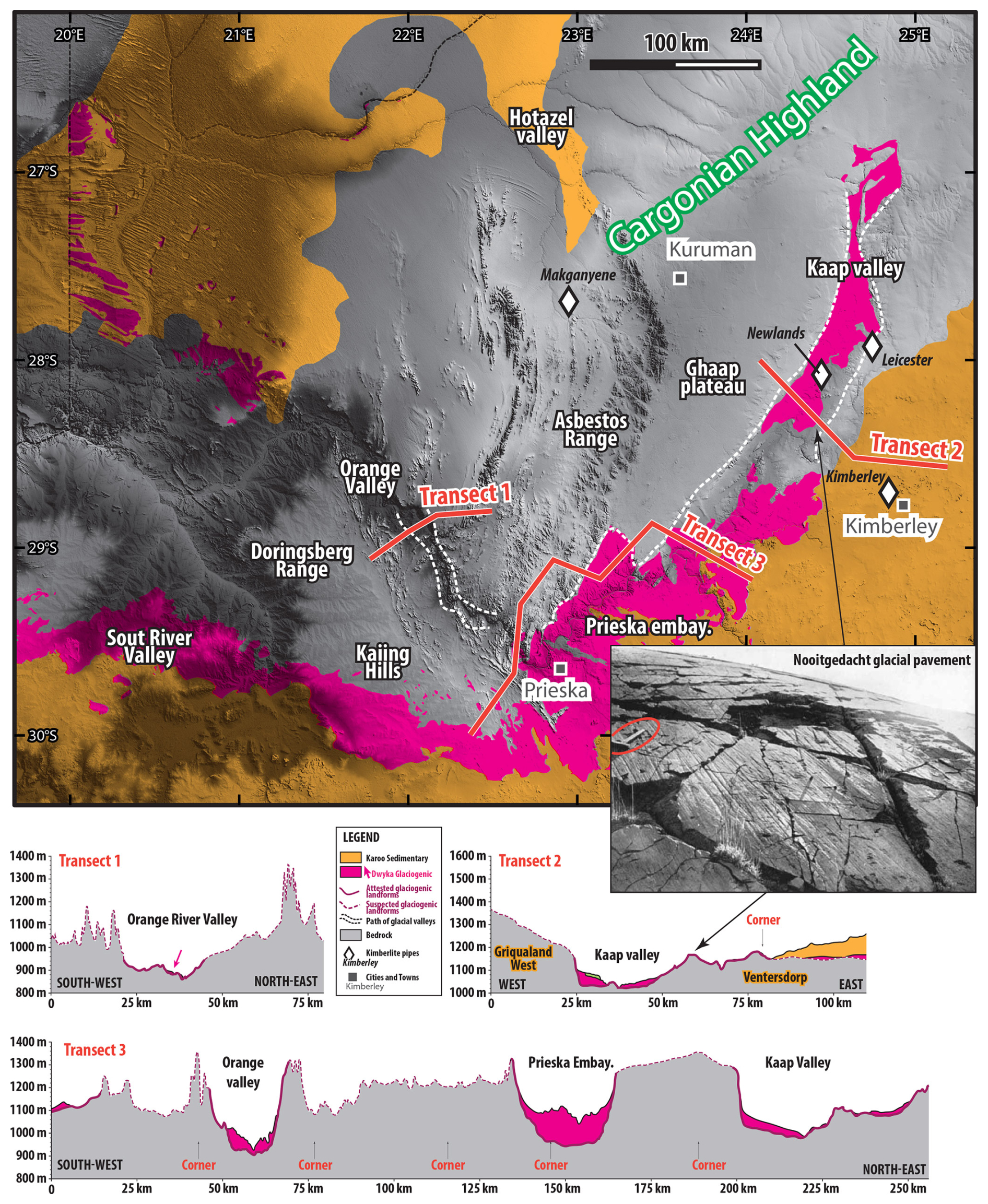
Figure 6DEM of the SW Cargonian Highland (central South Africa and southern Botswana, from the Shuttle Radar Topography Mission (https://www.earthdata.nasa.gov/data/instruments/srtm, last access: 16 June 2025); see Fig. 1b for location) and associated geological transects. Widespread Dwyka outcrops in the Kaap Valley visible in the landscape interpreted here as an exhumed glacial valley. Diamonds represent kimberlite pipes used for reconstruction in Fig. 11. Inset photo: close-up view of the Nooitgedacht glacial pavement (whaleback) in Slater et al. (1932). Circled hammer on the left for scale.
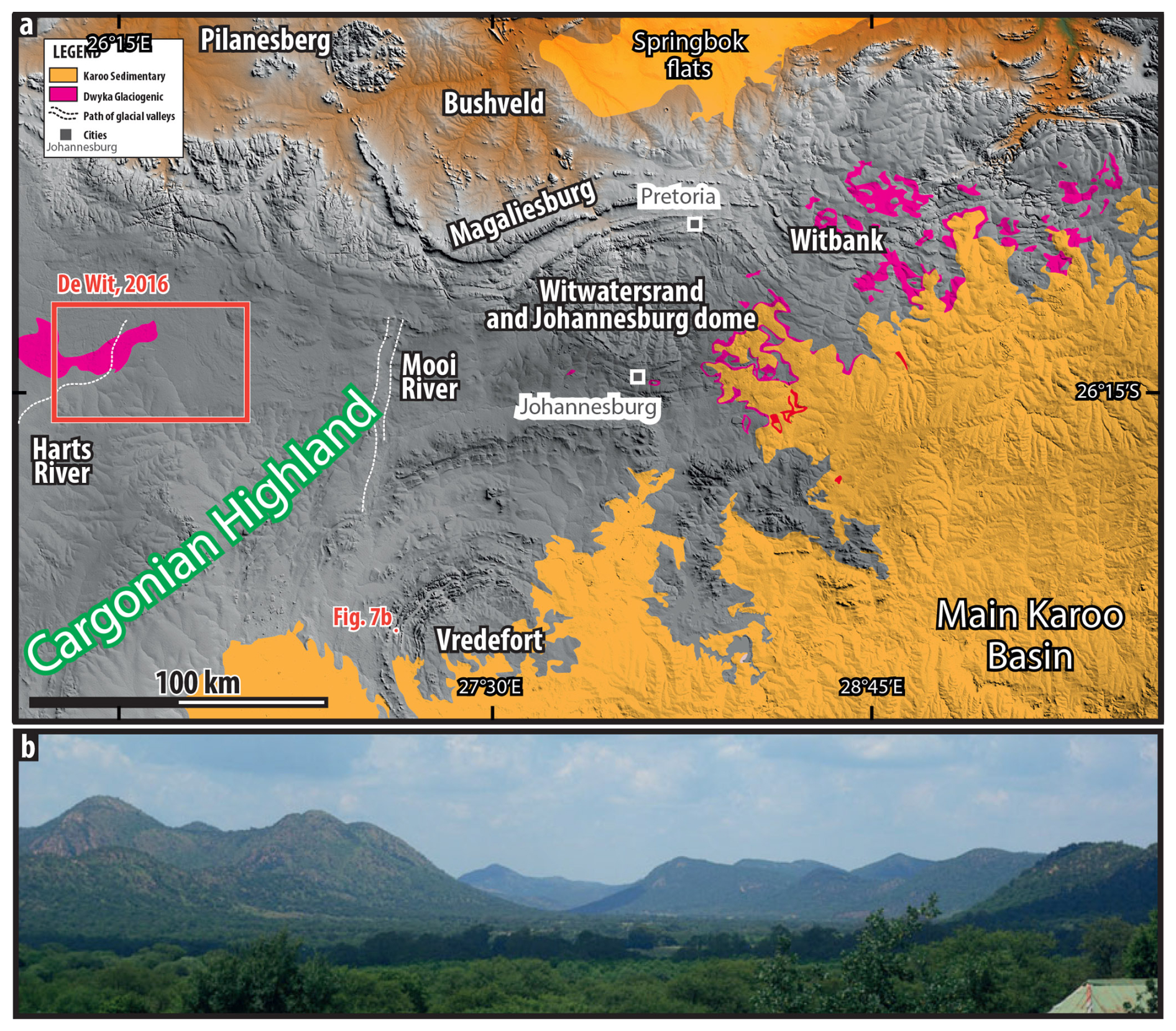
Figure 7(a) DEM of the central Cargonian Highland (Johannesburg–Pretoria–Witwatersrand area on the Kaapvaal Craton, central South Africa), from the Shuttle Radar Topography Mission (https://www.earthdata.nasa.gov/data/instruments/srtm, last access: 16 June 2025). See Fig. 1b for location. The Mooi and Harts River valleys, highlighted by dashed white lines, and the surrounding areas are interpreted by De Wit (2016) as an exhumed glacial surface. Similarly, the Witbank region to the east and the Vredefort Dome to the south are also interpreted as exhumed glacial surfaces (see text for detail). In between, the Witwatersrand region, the Magaliesberg range, the Pilanesberg Dome, and the cities of Johannesburg and Pretoria also probably sit on a glacial surface, although further work needs to be done to confirm such a hypothesis. (b) View of the Vredefort Dome area where the Vaal River valley shows a U-shaped profile reminiscent of glacial erosion. A small portion of the Vaal River floodplain is seen on the center right (Fig. 4.5 in Gibson and Reimold, 2015).
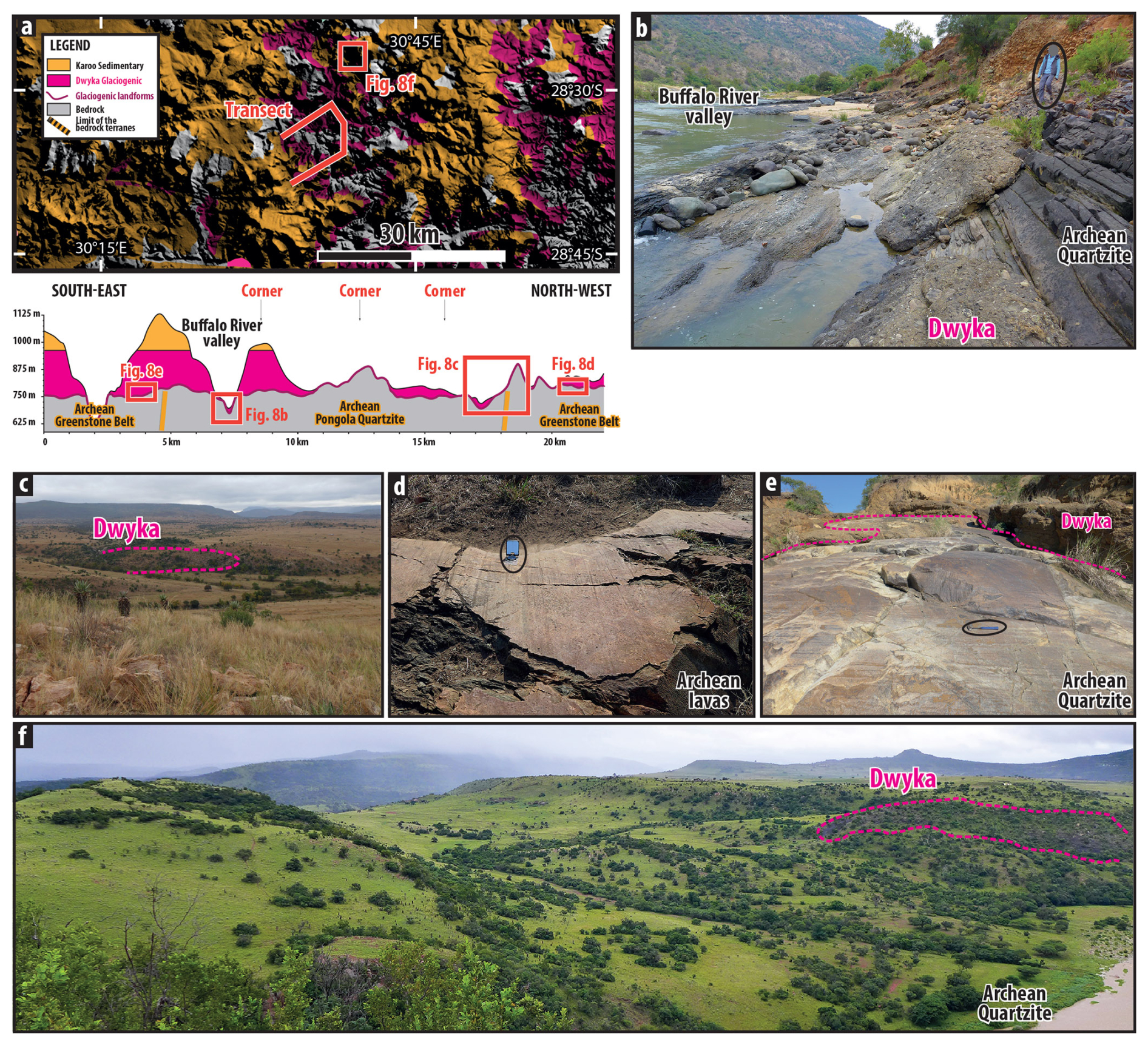
Figure 8(a) DEM of the eastern Cargonian Highland (edge of the Main Karoo Basin; Kaapvaal Craton, eastern South Africa), from the Shuttle Radar Topography Mission (https://www.earthdata.nasa.gov/data/instruments/srtm, last access: 16 June 2025), and morphostratigraphic transect highlighting the Tugela Valley as an exhumed glacial landscape. See Fig. 1b for location. See details in Dietrich and Hofmann (2019). (b) Bank of the Buffalo River exhuming a glacial valley. Stratified, steeply dipping rock on the right corresponds to Archean Pongola Supergroup quartzite into which steep-flanked reliefs were carved and upon which coarse-grained deposits corresponding to glaciogenics of the Dwyka Group are plastered. Although the Dwyka sediments are steeply dipping on the flank of the (paleo)valley, they become horizontal in the river thalweg. Circled geologist for scale. (c) Landscapes of rolling hills corresponding to an exhumed glacial landscape. The relief is carved into Archean Pongola quartzite seen in the foreground: topographic lows preserve remnants of glaciogenic sediments whose bulk has been eroded away by recent erosion, resurrecting the glacial landscape. Striated pavements, such as the ones showcased in Fig. 7d and e, characterize basement floors. (d) Striated floors carved onto volcanic rocks of the Archean greenstone belt, plucking of the joint at the foreground, indicate an SSW ice movement. (e) Striated and polished glacial floor exposed in a stream, and showcasing a small-scale roche moutonnée behind the circled hammer, evidencing an ice movement to the SSW. The glacial floor is still covered in place by remnants of glaciogenic sediments. (f) A U-shaped trough, 800 m wide and 100 m deep carved by glacial erosion into Archean Pongola quartzites. Remnants of glaciogenic sediments are still present. Picture from Dietrich and Hofmann (2019). Photo credit for panels (b) to (f): Pierre Dietrich.
Further south, the Vredefort Dome, a 2.1 Gyr old meteorite impact structure, displays numerous remnants of glacial erosion processes such as striae, grooves and profiled hills, and patches of glaciogenic sediments as well as far-traveled boulders. The upper Vaal River which crosscuts parts of the impact structure has a U-shaped profile which can be interpreted as the remnant of a glacial valley (Fig. 7b). Together, this indicates that the modern landscape of the Vredefort Dome corresponds to a fossil, pre-Karoo glacial landscape (King, 1951; von Gottberg, 1970; Gibson and Reimold, 2015).
At the easternmost edge of the Main Karoo Basin (Figs. 1 and 8), the removal of less-resistant Karoo strata exhumed LPIA glacial landscapes sculpted into resistant Archean granites, greenstones, and quartzites (Dietrich and Hofmann, 2019). The Buffalo River valley follows an inherited 100–140 m deep glacial trough carved into Pongola Supergroup quartzites, abrupt valley flanks (30–60°) made of quartzites draped by glaciogenic clast-rich diamictites that become horizontal in the valley thalweg (Fig. 8b). In the intervening interfluves, the landscape of rolling hills made of Archean quartzites and greenstone belt volcanics constitutes an exhumed landscape of areal scouring as indicated by pockets of glaciogenic sediments in paleotopographic depressions, whereas paleohighs are made of basement rocks (Fig. 8c), which often display hard-bed striated pavements (Fig. 8d and e). These hills and hollows may therefore represent crag and tails and a field of large roches moutonnées. An exhumed U-shaped glacial trough, 800 m wide, 100 m deep, and 2 km in which remnants of glaciogenic sediments occur, has also been observed (Fig. 8f, Dietrich and Hofmann, 2019).
The northern margin of the MKB over the Cargonian Highland hosts glaciogenic Dwyka Group rocks which reflects a threefold segmentation with regard to the paleotopography, as emphasized by numerous authors (Visser, 1987a, b; Von Brunn, 1994; Von Brunn, 1996; Haldorsen et al., 2001; Johnson et al., 2006; Isbell et al., 2008; Tankard et al., 2009; Dietrich and Hofmann, 2019; Griffis et al., 2019a, 2021). (1) The basement-high facies association, deposited on the Cargonian Highland, seldom exceeding a few meters in thickness, is represented by massive to poorly stratified diamictites representing subglacial till or esker deposited on land (De Wit, 2016). (2) The valley-fill facies association (sometimes referred to as the Mbizane Formation), up to 300 m in thickness but characterized by rapid thickness changes, consists of an alternation between massive and stratified diamictites, sandstones, and conglomerates, whose deposition was largely controlled by the underlying relief and corrugated topography such as escarpments and valley walls carved into the escarpment delineating the highland. (3) The platform–basin facies association (Elandsvlei Formation) is recognized at the center of the Main Karoo Basin, commonly reaching 800 m in thickness, consisting of alternation between diamictite and mudstone (marine to glaciomarine) units deposited in deep glaciomarine environments representing ancient lowlands.
3.4 The Zimbabwe Highland
The Zimbabwe Highland corresponds to the central region of Zimbabwe and the Zimbabwe Craton (Figs. 1 and 9). This highland is floored by Archean greenstone belts, granites, and other resistant lithologies that were intruded during the late Archean by the layered complex of the Great Dyke (Mukasa et al., 1998). Over the basement lies the Karoo Supergroup represented by isolated, ca. 100 m thick sedimentary successions at the base of which glaciogenic sediments are sometimes present (Bond, 1970) and capped by 50–100 m thick Jurassic lavas of the Drakensberg Group (Rhodesia Geol. Map 1971: https://zimgeoportal.org.zw, last access: 13 February 2025). Lister (1987) comprehensively detailed the polyphased, polygenic nature of the pre-Karoo surface, emphasizing the role of glacial and non-glacial erosion processes, pediplanation, folding, and structuration that happened before (or during, over basement outliers) the deposition of the Karoo sediments. This pre-Karoo surface, characterizing vast region of Zimbabwe, has then been covered and re-exhumed, and as a result, largely due to erodibility contrast between the basement rocks and the sedimentary cover, “in many respects the Pre-Karoo landscape of Zimbabwe was remarkably similar to that existing at the present day” (Lister, 1987).
The Great Dyke now forms a prominent morphological ridge that stands well above the surrounding basement-floored rocks of central Zimbabwe (Fig. 9). In the Featherstone region, east of the Great Dyke, the Archean Mwanesi Greenstone Belt also forms a prominent ridge against which the Karoo sediments onlap (Fig. 9). Although no glaciogenic sedimentary series have formally been identified on geological maps (“undifferentiated Karoo”) and no field study has reported glaciogenic sediments, to our knowledge, the surrounding sedimentary basins encompass evidence for glacial processes (mid-Zambezi: Bond and Stocklmayer, 1967; Bond, 1970; Cabora Bassa: Oesterlen and Millsteed, 1994; Fernandes et al., 2023; Somabula: Moore and Moore, 2006; Tuli: Bordy and Catuneanu, 2003; MacGregor, 1921). We therefore posit that the Mwanesi Greenstone Belt and the Great Dyke formed prominent reliefs during LPIA times as proposed by Lister (1987). This relief, sealed by Karoo rocks, is now being exposed by the erosion of the sedimentary rocks and basalts. Furthermore, Moore et al. (2009) suggested that U-shaped valleys, canyons, defiles, and ravines (locally named “poort”, meaning gateway in Afrikaans), incised through this greenstone belt as well as through the Great Dyke within which modern streams flow, do not match any structural pattern and cannot have been cut by these streams. Rather, the incision corresponds to exhumed glacial valleys that are now used by streams to cross the topographic barriers (Moore et al., 2009).
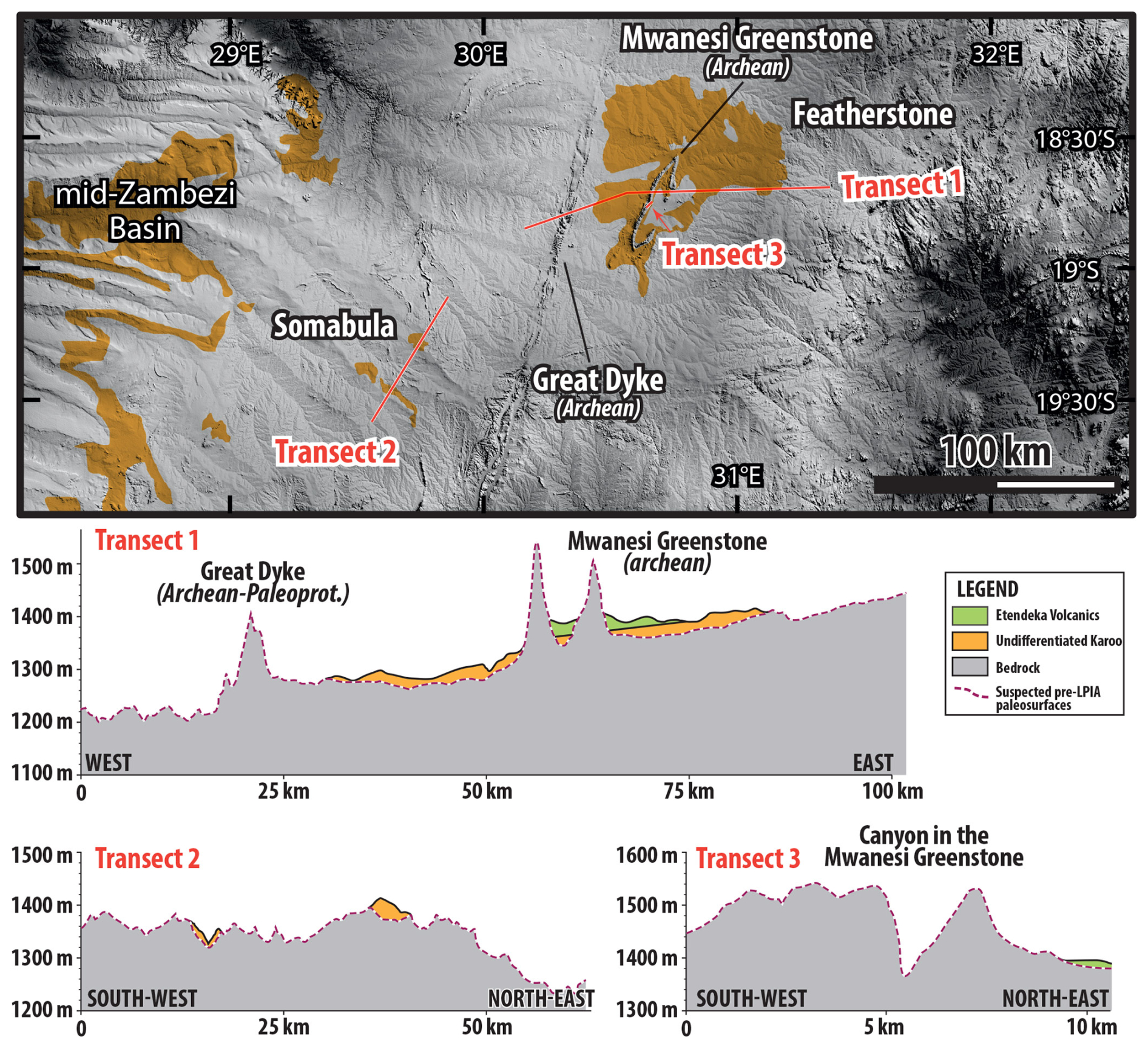
Figure 9DEM of the Zimbabwe Highland (central Zimbabwe), from the Shuttle Radar Topography Mission (https://www.earthdata.nasa.gov/data/instruments/srtm, last access: 16 June 2025), and morphostratigraphic transects across the Great Dyke, the Mwanesi Greenstone Belt, and the Somabula region. The reader is redirected to Moore and Moore (2006), Moore et al. (2009), and Lister (1987) for further details and to Fig. 1b for location.
Further SW, in the Somabula region (Fig. 9), patches of diamond-bearing sediments attributed to Dwyka-filled hollows and topographic depressions are carved into Archean granite (Moore and Moore, 2006). The uneven topography onto which the Dwyka lies could correspond to a glacial topography, possibly partly reworked later during deposition of the Upper Karoo Supergroup. This pre-Karoo glacial landscape should be more degraded where removal of the Karoo cover occurred earlier, but at proximity of Karoo outliers, the glacial landscape must be pristine (Lister, 1987). Future field campaigns may reveal glacial features that may provide valuable clues on glacial processes and associated paleolandscapes.
4.1 The glacial paleolandscapes of Southern Africa
We have compiled the landscapes that existed during the LPIA and distinguished the attested ones from the suspected ones at the scale of Southern Africa, as presented in the form of a map in Fig. 10a. On this map, only valleys with geomorphic–sedimentological evidence for glacial processes are mapped as attested glacial landscapes, while their interfluves are mapped as suspected. The main and foremost finding deduced from our analysis is that, over Southern Africa, an area of ca. 71 000 km2 consists in attested exhumed glacial landscapes and an area 360 000 km2 corresponds to suspected glacial landscapes, which together correspond to ca. 10 % of the total area of the region (Fig. 10a). Compared to the area floored by a substrate older than the Karoo Supergroup, i.e., older than ca. 300 Ma (ca. 1 700 000 km2), this proportion rises to ca. 25 %, as the glacial paleolandscapes are mostly found on the paleohighlands formed by Archean and Paleoproterozoic terrains.
From that map, it appears that some aspects of the modern geomorphology of Southern Africa in fact correspond to ancient, re-exhumed paleolandscapes – the pre-Karoo topography that, as discussed below, may originate from glacial and older, non-glacial erosion processes and surficial expression of basement structures. Notably, some modern escarpments are exhumed paleoescarpments delineating the paleohighlands from the basins, such as in the Kaoko region of Namibia or along the Kaap Valley in South Africa. In other instances, the escarpment is still buried under Karoo sediments, such as in central South Africa and Lesotho and southern Botswana, deduced from an abrupt increase in thickness in Dwyka glaciogenic sediments toward the south, as observed from drilling (Fig. 10a; see Visser, 1987a, b). Moreover, the modern river drainage follows the pattern of inherited glacial relief: the Vaal River in the Kaap Valley and the Orange River in the Orange Valley (South Africa); the Kunene and other NW Namibian rivers in the fossil fjords; the Ugab, Swakop, and Black Nossob rivers; and the Zambezi River funneled by the Zambezi escarpment (Zimbabwe). In addition, narrow ravines cut into prominent topographic barriers – such as the Great Dyke and Mwanesi in Zimbabwe, the Magaliesberg and Doringsberg–Asbestos mountains in South Africa, and the Naukluft in Namibia – seem to correspond to exhumed glacial gorges.
4.2 Paleogeography
The map of attested and suspected exhumed glacial paleolandscapes (Fig. 10a), the compilation of sedimentary facies as well as previous local paleogeographic reconstructions (e.g., Smith, 1990; Lister, 1987; Visser, 1983, 1985, 1987a, b, 1989, 1992, 1993, 1997; Daly et al., 1989; Von Brunn, 1994, 1996; Veevers et al., 1994; Smith et al., 1993; Johnson et al., 1996, 1997; Haldorsen et al., 2001; Isbell et al., 2008; Dietrich et al., 2019, 2021), is used to construct the paleogeographic configuration of Southern Africa at the end of the LPIA (Fig. 10b). The threefold morphological pattern is highlighted, with (1) highlands and (2) escarpments into which glacial valleys and fjords are incised and that lead downstream to (3) sedimentary basins (the Karoo basins) that correspond to the lowland counterparts of the highlands.
We propose that the original extent of the Karoo basins was greater than their modern outcrops, as offshore data indicate the presence of Karoo sediments on the modern continental margin. As the offshore Walvis and Lüderitz basins host Karoo sediments (Clemson et al., 1997, 1999; Aizawa et al., 2000; Baby et al., 2018b, 2020), we have extended the Aranos and Kaoko basins further west and connected them to their offshore counterparts. Martin (1973b) states that, as no glacial erratics sourced from the Kaoko have been found in the Paraná Basin, the Brazilian Karoo equivalent, a topographic depression or a basin, perhaps oceanic, should have existed between Namibia and Brazil during the LPIA, likely corresponding to the northern realm of the Walvis Basin. And Martin concludes that “paleogeographic evidence does not easily fit into the concept of a direct join of the African and the South American continental plates” (p. 294). Griffis et al. (2021) moreover indicate that only Gondwanan-scale deglacial events permitted the delivery of African-sourced sediments into the Paraná Basin while glacial flows between Africa and South America were hindered, suggesting the presence of substantial topographic barriers such as a basin that would have deflected/hindered ice flows. For the connection between the Aranos and Lüderitz basins and their extent further west, the absence of sediments between these offshore–onshore realms would be explained by their removal through the post-Gondwana-breakup function of the escarpment passive margin (see Sect. 2.4; Braun et al., 2014; Braun, 2018), which nowadays delineates the western border of the Aranos Basin. This escarpment therefore postdates the LPIA. In line with this, Visser (1987b) states that “Towards the west, [the Kalahari] basin probably opened into a sea. Martin (1973b) favoured the extension of the Kalahari basin into South America as goniatites of the same subgenus were found in Uruguay and Namibia in very similar stratigraphic positions. Those deposits, however, formed during an interglacial period when large parts of SW Gondwana were inundated as a result of sea-level rise”. About the offshore continuation of the Main Karoo Basin, Karoo sediments have also been found both in the offshore Orange Basin to the west (the South Atlantic sea arm of Visser, 1987b; see also Baby et al., 2018b) and in the Durban Basin (Baby et al., 2020) and on the Falkland Islands/Islas Malvinas (the Dwyka-equivalent Fitzroy tillite), whose restored position is off the modern SE coast of South Africa (Hyam and Marshall, 1997; Meadows, 1999; Stone, 2016). Finally, the Karoo sediments may have extended up to the modern coast of Mozambique, as Karoo sediments crop out at the South Africa–Mozambique border, dipping west (Viljoen, 2015), and Karoo sediments and volcanics are observed on seismic imagery at the base of the Limpopo and Zambezi coastal basins (Salman and Abdula, 1995; Ponte et al., 2019; Senkans et al., 2019; Roche et al., 2021; Roche and Ringenbach, 2022).
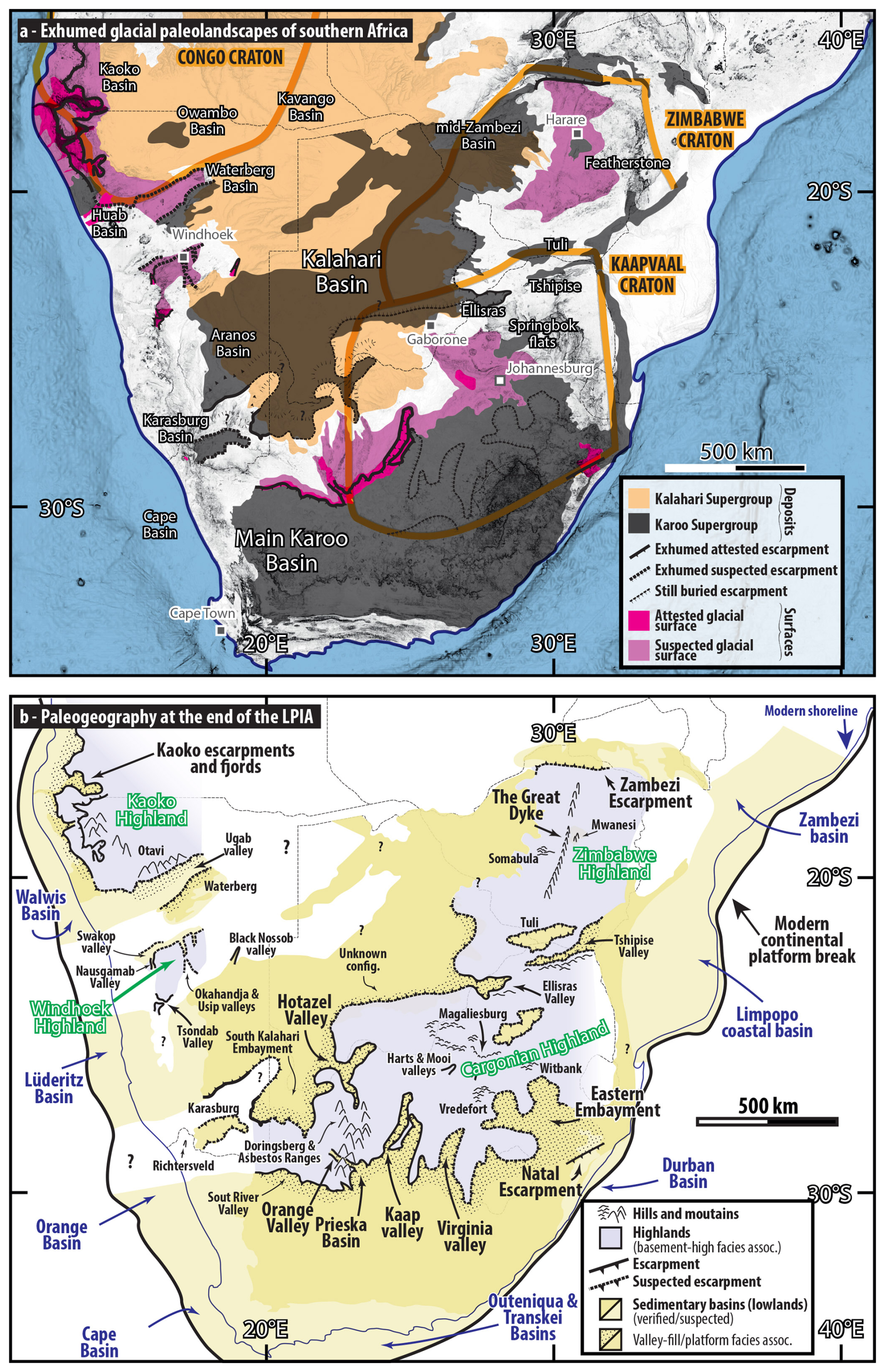
Figure 10(a) Synthesis of glacial paleolandscapes at the scale of Southern Africa. Dark pink indicates attested glacial surface and light pink indicates suspected glacial surfaces whose compilation is based on the presence of glacial morphological features (see text for details). Dark-gray regions are Karoo basins. Exhumed paleoescarpments are represented by black bold lines, and escarpments still buried under sediments are after Visser (1987a, b). The light-orange region corresponds to surficial sediments of the Kalahari Desert, after Haddon (2005). (b) Proposed paleogeographic reconstruction of Southern Africa at the end of the LPIA. Blue-gray areas represent highlands whose names are written in green; sedimentary basins are represented in dark yellow where attested or light yellow where suspected. Escarpments delineating the highlands from the basins and glacial valleys carved into them are represented as bold solid lines where attested or as dashed lines where suspected (see Visser, 1987a, b). Hills or mountainous regions are also indicated. The region where no data are available mostly corresponds to the Kalahari Desert – see Fig. 10a above. Names of glacial valleys and escarpments refer to those discussed in the text to which the reader is redirected for further details. DEM from the Shuttle Radar Topography Mission (https://www.earthdata.nasa.gov/data/instruments/srtm, last access: 16 June 2025).
4.3 Preservation of the glacial paleolandscapes
The preservation through geological times of the fossil glacial landscapes and their modern exposure (Fig. 10a) is achieved through an early burial – the deposition of the Karoo Supergroup – in order to preserve landforms from postglacial erosion and a geologically recent re-exposure achieved by stripping off this sedimentary cover. We provide in Fig. 11 a synthesis of the burial–exhumation trends of these fossil glacial landscapes on the basis of data available in the literature, such as sedimentological, stratigraphic, magmatic, geomorphologic, and thermochronometrical data, as well as other available information for constraining uplift and erosion, such as the location, ages, and exhumation history of kimberlite pipes and erosion–deposition budgets (see Sect. 2.4). The burial–exhumation history is given for the Kaoko paleohighland (Fig. 11a), the southern margin of the Cargonian paleohighland (Fig. 11b), and the Zimbabwe paleohighland (Fig. 11c). To reconstruct the burial–exhumation history using thermochronometric data – such as apatite and zircon fission tracks as well as (U–Th–Sm)/He analyses on apatite – geothermal gradients of 25 °C km−1 are assumed for the Kaoko, Zimbabwe, and Cargonian highlands (Mackintosh et al., 2019; Macgregor et al., 2020). As an example, a warming/cooling of 100 °C would indicate a burial/exhumation of 4 km. The history proposed here spans the whole period between the LPIA (ca. 300 Ma) and today. Given the discrepancies in data availability between these three regions, the level of details is significantly different and the stages/ages highlighted may not be equivalent. Also, significant discrepancies may exist between different thermochronometrical-kimberlite pipe-sediment budget data for a single region, leading to profound differences in inferred rate, timing, and amplitude of burial–exhumation processes (see also discussion in Chardon, 2023). For example, over the Kaoko Highland (Fig. 11a), thermochronometric data from Margirier et al. (2019) and Raab et al. (2005) indicate different times when these rocks passed through the temperature range of 120–60 °C. The former suggests significant cooling of approximately 200 °C between 130 and 100 Ma, while the later indicates cooling of about 120 °C between 100 and 65 Ma. Over the Cargonian Highland of South Africa (Fig. 11b), Wildman et al. (2016) postulate a sustained and continuous cooling of 50 °C since the LPIA until today, while Baughman and Flowers (2020) and Flowers and Schoene (2010) indicate an early warming (50–80 °C between 300 and 250 Ma) later followed by a 80–100 °C cooling around 100 Ma. Altogether, however, the combination of the different data points toward a twofold burial–exhumation history broadly common to the three highlands, characterized by an early burial (the deposition of the Karoo sediments in the immediate aftermath of the LPIA and later volcanics until 183 Ma, the date of the outpouring of the Drakensberg LIP) and a late exhumation tied to the polyphase activity of the African superplume (Fig. 11).
In the following, we list the parameters that are necessary for this relict pre-Karoo topography and the glacial landforms to be preserved and cropped out.
- i.
The glacial erosion surfaces were covered by (Karoo) sediments not long after their carving which protected them from erosion and further obliteration.
- ii.
The sedimentary piles that covered these surfaces were then eroded away by post-LPIA erosion, in order to expose the relict surfaces (Fig. 1b). Over paleohighlands and/or area characterized by weak subsidence, limited sedimentary accumulation and re-exposed glacial surface contrast with the center of the Karoo basins where the sedimentary piles are too thick to have been eroded away in recent times. At the other end of the spectrum, areas that experienced early exhumation – due to having been covered by only thin sediments, been not covered at all, or experienced early tectonic uplift – have been eroded away and overprinted by more recent erosion processes. Lister (1987) summarized this concept as “Older landsurfaces […] are thereby buried or fossilized until such time as the overlying sediments or lavas are removed, thus permitting the older landsurfaces to become subaerial once again. Modern erosion quickly destroys the resurrected landsurfaces so that their original form is most accurately seen in proximity to their contact with the cover”. In fact, the preservation of delicate striae and other micro- to meso-scale erosional forms requires an almost immediate burial and a very recent exhumation which led to their re-exposure.
- iii.
The erodibility contrast between the weathering-resistant Archean to Proterozoic basement (metamorphic and magmatic–granitic rocks) into which the glacial reliefs developed and the weaker, prone-to-erosion sedimentary (prone to mechanic erosion) and volcanic (prone to weathering) cover likely played a significant role in rejuvenating these surfaces (see also Braun et al., 2014). Accordingly, post-LPIA erosion was likely significantly slowed down when reaching the basement that therefore acted as a structurally controlled erosion surface.
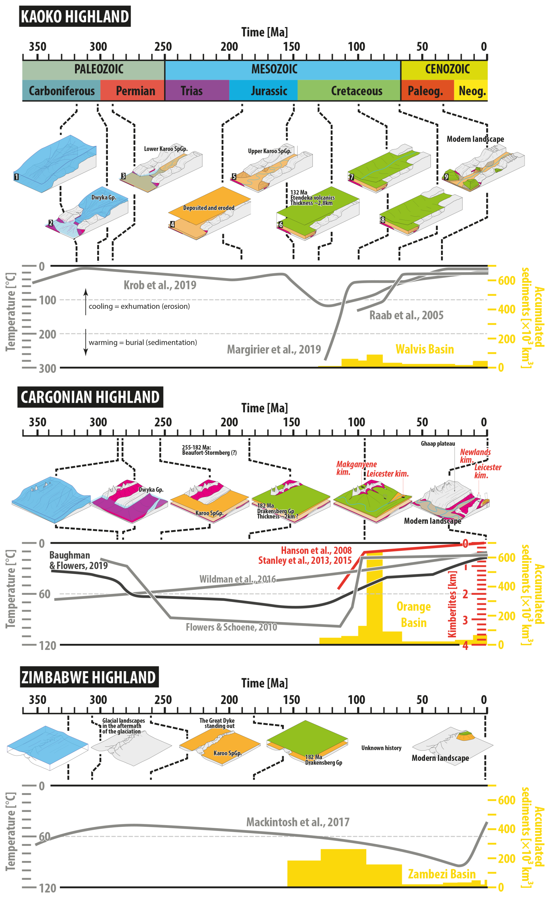
Figure 11Burial–exhumation history models the Kaoko (Fig. 2), Cargonian (Fig. 6), and Zimbabwe (Fig. 9) highlands. Thermochronological inferences are provided in the graphs, exhumation evidenced from kimberlites for the Cargonian highlands is displayed in red, and sediment volume accumulated on the continental margins is showcased in yellow. Raab et al. (2005), Krob et al. (2020), and Margirier et al. (2019) for the Kaoko; Stanley et al. (2015, 2021, 2023) and Wildman et al. (2015) for central South Africa and Mackintosh et al. (2017) for central Zimbabwe.
4.4 Implication for quantifying finite uplift of Southern Africa
The preservation of relief inherited from the LPIA may provide valuable clues about their paleoaltitudes and local finite uplift of the lithosphere since the late Paleozoic. Indeed, the paleofjords of Namibia bear sedimentological evidence for coastal, and sometimes even intertidal, environments (Dietrich et al., 2021), providing the paleo-zero altitude. The presence of such coastal–intertidal sediments in the Hoarusib Valley (Dietrich et al., 2021), today observed at 300–400 m above modern sea level ca. 50 km away from the modern shoreline, indicates that the finite uplift of this region since the late Paleozoic was of a similar value. Within this same Hoarusib Valley, but 120 km upvalley, near the town of Opuwo, glaciomarine, i.e., submarine, sediments lie today at 1200 m a.s.l., indicating there an uplift of at least 1200 m since the LPIA and therefore also a differential uplift of ca. 7 m km−1 between these two localities. This would apply to any region where sediments indicating zero altitude would be found. Secondly, the presence of coastal sediments within paleovalleys indicates that their interfluve immediately after the LPIA stood at an altitude corresponding to at least the elevation difference between them and the valley thalwegs, considering that the interfluves may have been eroded and leveled down since then.
5.1 Pre-LPIA evolution: existing reliefs amplified by glacial erosion?
We have shown that Southern Africa is characterized by exhumed paleolandscapes displaying geomorphic evidence for glacial erosion processes. These landscapes therefore date at least back to the LPIA, ca. 300 Ma. Accordingly, this surface has been termed “ancestral glacial pre-Karoo peneplain” (Wellington, 1937), “sub-Karoo surface” (King, 1949a), or more specifically “pre-Dwyka topography” (Du Toit, 1954; von Gottberg, 1970). However, an array of sedimentological, thermochronometrical, structural, and morphological data suggest that glacial erosion processes may have in fact reshaped and/or amplified an even older land surface that existed before LPIA times, formed by alluvial erosion processes, by pediplanation, and by surficial expression of basement and tectonic structures such as faults and folds. The pre-Karoo landscape, in its multiple expression, would therefore be polygenic and polyphased, with the glacial erosion processes being the last episode of a long history of surficial processes (e.g., Lister, 1987; de Wit, 2016). Just as it is the case for Quaternary glacial landscapes (Jess et al., 2019), the pre-Karoo landscape probably resulted from a combination of ice sheet dynamics, pre-glacial landscape evolution, and underlying geology. The preservation of preglacial forms, at least locally or regionally, would finally suggest that glacial erosion was minimal enough to prevent their complete obliteration, which could ultimately lead to a quantification of glacial erosion during the LPIA.
5.1.1 Highlands and escarpments: surficial expression of basement structure and tectonic activity?
The threefold morphological pattern (highlands, escarpments, and sedimentary basins) that greatly controlled the mode of glaciogenic sedimentation seems to correspond to surficial expression of basement structures (Fig. 12). Indeed, the highlands correspond to Archean and Paleoproterozoic cratons, while the escarpments edging the highlands match crustal-scale faults, either delineating the cratons and their surroundings accreted terranes or intra-cratons faults (Figs. 1 and 12; Daly et al., 1989; Tankard et al., 2009; Begg et al., 2009). The escarpments may therefore correspond to fault offsets, with glacial valleys carved into it. And, in order for the glacial valleys to be carved into it, these fault escarpments must have formed before or during the development of the ice masses of the LPIA, implying relative uplift of the cratonic areas and subsidence of the surrounding terranes. Below are speculations of the possible timing and processes involved in pre-LPIA vertical movements that led to the partitioning between highlands and lowlands separated by escarpments.
The Kaoko region of NW Namibia corresponds tectonically to the Kaoko branch of the Pan-African orogen that developed between the Congo Craton and other terranes between 580 and 480 Ma (Goscombe and Gray, 2008). There, the escarpments edging the Kaoko Highland into which paleofjords are carved correspond to faults delineating the Congo Craton to the east and the Kaoko belt to the west (Fig. 12a; Goscombe and Gray, 2008). Therefore, considering the crustal structure of the region prior to and during the LPIA, two hypotheses for the genesis of the escarpment – a fault offset – and the existence of the high ground are suggested, as summarized in Fig. 12a:
-
Hypothesis 1, peneplanation and rejuvenation. In this hypothesis, relief generated during the Pan-African orogeny that terminated around 480 Ma would have been flattened, possibly through peneplanation for 180 Myr, until the LPIA. Immediately before or during the LPIA, tectonic processes such as subsidence of the Kaoko belt and/or uplift of the Congo Craton reactivated basement structures and faults inherited from the Pan-African orogeny and rejuvenated their surficial expression (Daly et al., 1989; Pysklywec and Mitrovica, 1999; Pysklywec and Quintas, 1999; Tankard et al., 2009). Tectonism and fault reactivation may relate to the extension as Karoo rift systems have been proposed for northern Namibia (Daly et al., 1989; Clemson et al., 1997, 1999; Aizawa et al., 2000). Such a late Paleozoic rift system would be signified by the thermochronometric data that indicate a period of enhanced exhumation during the Devonian–Carboniferous after a quiescent period that lasted between the Cambrian and the Devonian, itself following a period of exhumation (curves 1, 2 and 3 in Fig. 11 of Krob et al., 2020), which we suggest may represent a peneplanation period.
-
Hypothesis 2, inherited high topography. The alternative hypothesis is that the topographic escarpment formed during the Pan-African orogeny, marking the topographic boundary between different tectonic provinces, the coastal terrane, and the Congo Craton, and persisted since then owing to incomplete peneplanation. This would indicate that the modern relief of the Kaoko is very old, dating to the early Phanerozoic, as it has also been suggested for the Scandinavian Margin by Pedersen et al. (2016) or the Canadian Shield by Ambrose (1964).
The southern flank of the Cargonian Highland in South Africa is also marked by an escarpment into which large glacial valleys are carved (the Kaap and Virginia valleys, Fig. 12b). These valleys funneled ice flows and controlled the mode of glaciogenic sedimentation. Here, the escarpment corresponds to crustal structures (Fig. 12b). Tankard et al. (2009) indicate that subsidence of the MKB started during the LPIA and was initially characterized by vertical motion of rigid crustal blocks that correspond to terranes accreted to the Kaapvaal Craton, accommodated by crustal-scale faults between these terranes in an epeirogenic context. On the one hand, in the central MKB, the Virginia glacial valley is fault-controlled as well as the promontory between the Virginia and Kaap valleys (Fig. 13b). However, the Kaap Valley does not seem to be associated with a fault and may therefore correspond to the head valley retreat that originated from the escarpment formed by the offset of the Doringsberg fault (Fig. 12b, second cartoon). On the other hand, in the eastern Karoo, the Natal escarpment into which smaller glacial valleys are carved corresponds to a basement step formed by the Tugela thrust front, delineating the Kaapvaal Craton to the north and Natal Province to the south (see Fig. 13 in Tankard et al., 2009).
It must finally be mentioned that the incision of fjords through the escarpment during the LPIA may have amplified an already existing topography through isostatic uplift (Fig. 12; Medvedev et al., 2018; Pedersen et al., 2019). Depending on the flexural rigidity of the lithosphere, the isostatic uplift would have been in the order of a third of the thickness of eroded material. Quantifying the depth of glacial erosion (valleys only vs. valleys and their interfluve) would therefore appear crucial for constraining the amount of postglacial isostatic uplift (see the notion of geophysical relief in Pedersen et al., 2019).
5.1.2 Valleys and plateaus: marks of pre-LPIA alluvial erosion processes?
Along with the crustal structure of Southern Africa, which may have largely contributed to creating the reliefs that existed at the onset of the LPIA, preglacial alluvial erosion processes might have contributed to shaping the relief later exploited by glacial ice during the LPIA, as indicated by sparse and sometimes indirect evidence, as listed below.
Over the Cargonian, Kaoko, and Zimbabwe Highland, thermochronometrical data indicate that cooling, which reflects exhumation, continuously prevailed since at least 500 Myr ago until the LPIA, suggesting that the LPIA was the ultimate episode of a >200 Myr long history of erosion. Over the Cargonian Highland, cooling occurred between 600–500 and 400 Ma, leaving ca. 100 Myr of erosion (Wildman et al., 2017; Baughman and Flowers, 2020). Moreover, no lower Paleozoic sedimentary basin exists over Southern Africa, with the notable exception of the Cape Basin, hosting the Cape Supergroup, spanning from the Cambrian to the Late Devonian. Provenance studies and paleocurrents indicate that sediments that fed the Cape Basin were sourced in the north, over the Namaqua–Natal suture belt, and funneled to the Cape Basin through a network of southward-flowing valleys (e.g., Theron, 1972; Fourie et al., 2011). The Kaap Valley may therefore correspond to such an alluvial valley later reused by the ice. Over the Kaoko Highland, cooling occurred between 550 Ma and the onset of the LPIA (Krob et al., 2020), leaving about 250 Myr for erosion. In Zimbabwe, Lister (1987) indicates the presence of a pre-LPIA pediplain and an “older [than LPIA] fluvial valley”, being part of the so-called “pre-Karoo fossil surface”, which would indicate alluvial processes. Therefore, we suggest that before the LPIA, most of Southern Africa, with exception of the Cape Supergroup, was an erosional landscape dominated by alluvial forms: valleys and possibly pediments and pediplains. At the onset of the LPIA, these networks of alluvial valleys may have controlled the path of local ice flows and its funneling into what later became the fjords punctured through the escarpment (see also Lister, 1987).
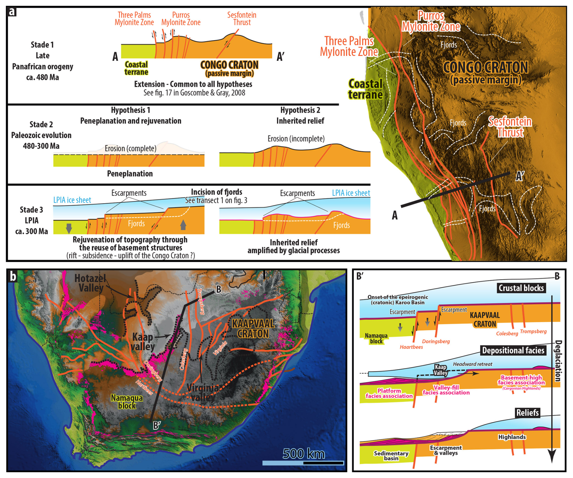
Figure 12(a) Structural map of the Kaoko Highland (Figs. 2 and 3); faults are after Goscombe and Gray (2008), and two alternative models for the evolution of the escarpments and the associated valleys before the LPIA are as follows. Hypothesis 1 implies that the relief created at the end of the Pan-African orogeny around 480 Ma was entirely leveled down before the LPIA and rejuvenated owing to vertical crustal movements during or immediately prior to the LPIA, whose ice flow carved valleys into it. Hypothesis 2 implies that the relief created by the Pan-African orogeny was only partly eroded during the time interval between the Pan-African orogeny and the LPIA and was amplified by glacial processes. The first stage representing the end of the Pan-African orogeny – extension tied to post-orogenic collapse – is common to both hypothesis and derived from Goscombe and Gray (2008). (b) Structural map of the Main Karoo Basin and the Cargonian highlands, faults after Tankard et al. (2009), and proposed model for the carving of the Kaap Valley (Fig. 6) that corresponds to a headward retreat of the valley due to glacial erosion from the offsetting Doringsberg fault. See text for details. DEM from the Shuttle Radar Topography Mission (https://www.earthdata.nasa.gov/data/instruments/srtm, last access: 16 June 2025).
5.2 Can the pre-Dwyka relief be mistaken for post-LPIA planation surfaces or rifts?
LPIA glacial valleys, like the Kaap Valley in South Africa or the paleofjords of NW Namibia, are U-shaped valleys prominent in the modern desert landscape. These valleys occur at different elevations, are incised within escarpments, and are separated by flat surfaces. Although glacial erosion processes played a major role in shaping these landforms, their origin likely also involves pre-glacial structural and/or alluvial processes. In this regard, these LPIA-related landforms resemble planation surfaces (pediments, pediplains, and pedivalleys) of the African surfaces described by Guillocheau et al. (2018b), which are interpreted as successive steps of staircases carved on the slopes of growing reliefs since ca. 30 Ma (e.g., Burke and Gunnell, 2008; Guillocheau et al., 2018b). This interpretation has recently been challenged by Chardon (2023), who argues that most of the tropical African highlands are inherited reliefs dating back at least to the Cretaceous. He further suggests that the apparent staircase-like arrangement of African planation surfaces is primarily controlled by long-term climatic processes rather than resulting from episodic epeirogenic uplift. In a complementary way, our study emphasizes the need to consider the morphological heritage, particularly related to the LPIA glacial erosion, when assessing the evolution and modern aspect of the landscapes of Southern Africa.
Alternatively, the glacial U-shaped valleys of Southern Africa can also be mistaken for post-LPIA, Mesozoic or Cenozoic rift or tectonic structures. The Kunene River valley, defining the border between Namibia and Angola, is a conspicuous glacial valley, with coarse-grained glaciogenic sediments and boulder-sized erratics plastered along its walls. Yet, this valley has been interpreted as structurally controlled by Brunotte and Spoenemann (2003). Many other valleys exhibit large-scale morphological features consistent with a glacial origin – U-shaped cross profiles, endorheic troughs suggesting glacial overdeepening, and valley directions radiating out of the Windhoek highlands – yet lack definitive evidence of glacial processes and have been classified as rifts by various authors. For instance, the Upper Ugab and Waterberg valleys of northern Namibia, as well as the Karasburg Basin of southern Namibia – interpreted by Martin (1973b) and Visser (1987b) as resulting from a glacial overdeepening – have been considered rift-related structures, alongside the Tshipise, Tuli, Ellisras, and Springbok Flats basins in South Africa and Zimbabwe (Daly et al., 1989; Smith and Swart, 2002; Frizon De Lamotte et al., 2015; Guillocheau et al., 2018a). However, the relatively thin accumulation of the Karoo Supergroup (100–200 m) within these basins (Holzförster et al., 2000; Smith and Swart, 2002; Bordy and Catuneanu, 2003; Johnson et al., 2006; Bordy, 2018), indicating very low accommodation and subsidence, largely incompatible with rift-related processes, and the absence of bounding faults in some cases question such a tectonic interpretation.
Linley A. Lister (née King, 1936–2016) wrote in 1987 in her treatise on “The Erosion Surfaces of Zimbabwe” that “In many respects the Pre-Karoo landscape of Zimbabwe was remarkably similar to that existing at the present day ” (p. 15). In the present contribution, we show that the same applies to many cratonic areas floored by Archean to Proterozoic rocks over Southern Africa. The attested geomorphic legacy of the LPIA in Southern Africa is present in the form of U-shaped valleys in Namibia and South Africa in which glaciogenic sediments are found and as fields of roches moutonnées and crag and tails in South Africa. Other forms are suspected to be glacial in origin, although no firm evidence has been found: valleys radiating out from the Windhoek highlands, ravines encased within mountain ranges, and small sedimentary basins. Many other landforms have existed at least since the LPIA but bear evidence for structural and/or alluvial processes and may have therefore been only reshaped and/or reused by glacial processes. These glacially modified forms are mountain ranges in Zimbabwe and South Africa and escarpments in which glacial valleys are incised in Namibia and South Africa. We therefore underscore the probable existence of a relict non-glacial landscape that prevailed before the LPIA and the extension of ice masses during the late Paleozoic that may have only slightly reshaped such forms. As it is the case for the Quaternary, the modern landscapes of Southern Africa may therefore represent a combination of glacial and alluvial erosion and tectonic–structural processes. We have also highlighted the importance of immediate deposition after the LPIA of volcanic and sedimentary cover in preserving the ancient landforms that must be restored to understand the evolution of the Southern African relief. Nowadays, after a 300 Myr long history of burial and exhumation, preserving them from weathering and erosion, these glacial landscapes have been resurrected and characterize the modern landscape of Southern Africa. Finally, these observations partly call into question the geomorphological studies carried out in Southern Africa, which have interpreted the shelving of the subcontinent as reflecting successive phases of uplift since the breakup of Gondwana (e.g., Partridge and Maud, 1997, 2000; van der Beek et al., 2002; Burke and Gunnell, 2008; Guillocheau et al., 2018b).
Whilst our findings apply for Southern Africa, similar inferences most likely hold for other cratonic areas that experienced the Late Paleozoic Ice Age, as demonstrated by widespread striated surfaces and glacial morphological features or suggested by ancient (Carboniferous–Permian) thermochronometric ages:
-
in South America, where paleofjords characterize the edge of Karoo-aged basins (Kneller et al., 2004; da Rosa et al., 2016; Tedesco et al., 2016; Mottin et al., 2018; Assine et al., 2018);
-
in vast regions of central Africa, which host relict glacial morphological features and glaciogenic sediments (Studt, 1913; Dixey, 1937; Boutakoff, 1948; Wopfner and Kreuser, 1986; Ring, 1995; Wopfner and Diekmann, 1996; Catuneanu et al., 2005b), where Carboniferous–Permian thermochronometric ages have been inferred for widespread erosion surfaces such as in Malawi (McMillan et al., 2022);
-
likely in Madagascar, where glacial strata are found at the very base of the Karoo-aged Majunga and Morondava sedimentary basins (Rakotosolofo et al., 1999);
-
in India, where Dwyka-equivalent strata lie on the cratonic bedrock (Casshyap and Srivastava, 1987; Dasgupta, 2020);
-
in Australia, where vast sedimentary basins bear Dwyka-equivalent strata over cratonic areas (Fielding et al., 2023); and
-
in Antarctica, where Rolland et al. (2019) postulate the presence of vast glacial landscapes inherited from the LPIA. It may even be conceivable that Cenozoic glacial erosion reused and superimposed glacial reliefs carved during the LPIA (e.g., Carter et al., 2024).
To construct the DEMs presented in this contribution, we have used freely accessible SRTM (Shuttle Radar Topography Mission) data one may access here: https://doi.org/10.5067/MEASURES/NASADEM/NASADEM_SIM.001 (NASA JPL, 2020).
PD, FG, GAD, NPG, DPL, LB, IPM, TG, CK, and AH participated in various field campaigns. PD and FG designed the study and with the help of all co-authors wrote the paper. PD, GAD, NPG, DPLH, IPM, TG, CK, and AH contributed to sections dedicated to the morphological analysis of glacial forms and their assessment in the field. PD, FG, GB, MM, CR, and AH contributed to sections dedicated to pre- and post-Karoo evolution, including the burial–exhumation history section. FG, GB, LB, and MM participated in field campaigns dedicated to pre- and post-Karoo geomorphic evolution.
The contact author has declared that none of the authors has any competing interests.
Publisher's note: Copernicus Publications remains neutral with regard to jurisdictional claims made in the text, published maps, institutional affiliations, or any other geographical representation in this paper. While Copernicus Publications makes every effort to include appropriate place names, the final responsibility lies with the authors.
This article is part of the special issue “Icy landscapes of the past”. It is not associated with a conference.
Ana C. Fonseca and Adrian M. Hall are warmly thanked for their thorough and detailed reviews and relevant suggestions that greatly led to the improvement of the paper. We dedicate this paper to Alexander du Toit (1878–1948), Henno Martin (1910–1998), Lester King (1907–1989), Linley Lister (1936–2016), Maarten de Wit (1947–2020), and Johann Visser, whose work laid the groundwork of the ancestral landscapes of Southern Africa.
This research received funding from the program TelluS of the Institut National des Sciences de l'Univers, CNRS, awarded to Pierre Dietrich. Guilhem A. Douillet received funding from the Ambizione grant of the Swiss Nationale Science Foundation (SNSF). Daniel P. Le Heron and Pierre Dietrich received funding from the South Africa–Austria joint project of the National Research Foundation (NRF) and the Österreichischer Austauschdienst (OEAD; project no. ZA 08/2019).
This paper was edited by Frances E. G. Butcher and reviewed by Adrian M. Hall and Ana Carolina Fonseca.
Aizawa, M., Bluck, B. J., Cartwright, J., Milner, S., Swart, R., and Ward, J. D.: Constraints on the geomorphological evolution of Namibia from the offshore stratigraphic record, Communs Geol. Surv. Namibia, 12, 383–393, 2000.
Ambrose, J, W.: Exhumed paleoplains of the Precambrian Shield of North America, Am. J. Sci., 262, 817–857, 1964.
Andrews, G. D., McGrady, A. T., Brown, S. R., and Maynard, S. M.: First description of subglacial megalineations from the late Paleozoic ice age in Southern Africa, PLoS ONE, 14, e0210673, https://doi.org/10.1371/journal.pone.0210673, 2019.
Assine, M. L., de Santa Ana, H., Veroslavsky, G., and Vesely, F. F.: Exhumed subglacial landscape in Uruguay: Erosional landforms, depositional environments, and paleo-ice flow in the context of the late Paleozoic Gondwanan glaciation, Sediment. Geol., 369, 1–12, https://doi.org/10.1016/j.sedgeo.2018.03.011, 2018.
Baby, G.: Mouvements verticaux des marges passives d'Afrique australe depuis 130 Ma, étude couplée: stratigraphie de bassin – analyse des formes du relief, Phd Thesis, Université de Rennes 1, 369, 2017.
Baby, G., Guillocheau, F., Boulogne, C., Robin, C., and Dall'Asta, M.: Uplift history of a transform continental margin revealed by the stratigraphic record: The case of the Agulhas transform margin along the Southern African Plateau, Tectonophysics, 731–732, 104–130, https://doi.org/10.1016/j.tecto.2018.03.014, 2018a.
Baby, G., Guillocheau, F., Morin, J., Ressouche, J., Robin, C., Broucke, O., and Dall'Asta, M.: Post-rift stratigraphic evolution of the Atlantic margin of Namibia and South Africa: Implications for the vertical movements of the margin and the uplift history of the South African Plateau, Marine and Petrol. Geol., 97, 169–191, https://doi.org/10.1016/j.marpetgeo.2018.06.030, 2018b.
Baby, G., Guillocheau, F., Braun, J., Robin, C., and Dall'Asta, M.: Solid sedimentation rates history of the Southern African continental margins: Implications for the uplift history of the South African Plateau, Terra Nova, 32, 53–65, https://doi.org/10.1111/ter.12435, 2020.
Backeberg, N. R. and Rowe, C. D.: Mega-scale (∼ 50m) Ordovician load casts at de balie, South Africa: Possible sediment fluidization by thermal destabilisation, S. Afr. J. Geol., 112, 187–196, https://doi.org/10.2113/gssajg.112.2.187, 2009.
Batchelor, C. L. and Dowdeswell, J. A.: The physiography of High Arctic cross-shelf troughs, Quaternary Sci. Rev., 92, 68–96, https://doi.org/10.1016/j.quascirev.2013.05.025, 2014.
Baughman, J. S. and Flowers, R. M.: Mesoproterozoic burial of the Kaapvaal craton, Southern Africa during Rodinia supercontinent assembly from (U-Th)/He thermochronology, Earth Planet. Sc. Lett., 531, 115930, https://doi.org/10.1016/j.epsl.2019.115930, 2020.
Begg, G. C., Griffin, W. L., Natapov, L. M., O'Reilly, S. Y., Grand, S. P., O'Neill, C. J., Hronsky, J. M. A., Djomani, Y. P., Swain, C. J., and Bowden, P.: The lithospheric architecture of Africa: Seismic tomography, mantle petrology, and tectonic evolution, Geosphere, 5, 23–50, https://doi.org/10.1130/GES00179.1, 2009.
Benn, D. I. and Evans, D. J. A.: Glaciers and glaciation, London, Hodder Edition, 817, https://doi.org/10.4324/9780203785010, 2010.
Blignault, H. J. and Theron, J. N.: Reconstruction of the ordovician pakhuis ice sheet, South Africa, S. Afri. J. Geol., 113, 335–360, https://doi.org/10.2113/gssajg.113.3.335, 2010.
Blignault, H. J. and Theron, J. N.: Diapirism and the fold zone controversy of the ordovician glaciomarine pakhuis formation, South Africa, S. Afr. J. Geol., 120, 209–222, https://doi.org/10.25131/gssajg.120.2.209, 2017.
Bond, G.: The Dwyka Series in Rhodesia, Proc. Geol. Assoc., 81, 463–472, https://doi.org/10.1016/S0016-7878(70)80007-4, 1970.
Bond, G. and Stocklmayer, V. R. C.: Possible ice-margin fluctuations in the Dwyka series in Rhodesia, Palaeogeogr. Palaeocl., 3, 433–446, https://doi.org/10.1016/0031-0182(67)90029-6, 1967.
Bordy, E. M.: Lithostratigraphy of the Tshidzi Formation (Dwyka Group, Karoo Supergroup), South Africa, S. Afr. J. Geol., 121, 109–118, https://doi.org/10.25131/sajg.121.0008, 2018.
Bordy, E. M. and Catuneanu, O.: Sedimentology of the lower Karoo Supergroup fluvial strata in the Tuli Basin, South Africa, J. Afr. Earth Sci., 35, 503–521, 2003.
Boutakoff, N.: Les Formations glaciaires et postglaciaires fossilifères, d'âge permo-carbonifère (Karroo Inférieur) de la région de Walikale (Kivu, Congo Belge), Mémoire de l'institut Géologique de l'Université de Louvain, 9, 124, 1948.
Braun, J.: The many surface expressions of mantle dynamics, Nat. Geosci., 3, 825–833, https://doi.org/10.1038/ngeo1020, 2010.
Braun, J.: A review of numerical modeling studies of passive margin escarpments leading to a new analytical expression for the rate of escarpment migration velocity, Gondwana Res., 53, 209–224, https://doi.org/10.1016/j.gr.2017.04.012, 2018.
Braun, J., Guillocheau, F., Robin, C., Baby, G., and Jelsma, H.: Rapid erosion of the Southern African Plateau as it climbs over a mantle superplume, J. Geophys. Res.-Sol. Ea., 119, 6093–6112, https://doi.org/10.1002/2014JB010998, 2014.
Brown, R. W., Summerfield, M. A., and Gleadow, A. J. W.: Denudational history along a transect across the Drakensberg Escarpment of Southern Africa derived from apatite fission track thermochronology, J. Geophys. Res.-Sol. Ea., 107, ETG 10-1–ETG 10-18, https://doi.org/10.1029/2001JB000745, 2002.
Brunotte, E. and Spoenemann, J.: Paleozoic glacial valley-systems in Namibia? New aspects, morphogenetic contradictions and morphotectonic relations: Congress of the International Union for Quaternary Research, 16, 118, https://gsa.confex.com/gsa/inqu/webprogram/Paper55555.html (last access: 23 June 2025), 2003.
Burke, K. and Gunnell, Y.: The African Erosion Surface: A Continental-Scale Synthesis of Geomorphology, Tectonics, and Environmental Change over the Past 180 Million Years, Memoir of the Geol. Soc. America, 201, 1–66, https://doi.org/10.1130/2008.1201, 2008.
Cairncross, B.: An overview of the Permian (Karoo) coal deposits of Southern Africa, J. Afr. Earth Sci., 33, 529–562, https://doi.org/10.1016/S0899-5362(01)00088-4, 2001.
Cairncross, B. and Cadle, A. B.: Palaeoenvironmental control on coal formation, distribution and quality in the Permian Vryheid Formation, East Witbank Coalfield, South Africa, Int. J. Coal Geol., 9, 343–370, https://doi.org/10.1016/0166-5162(88)90031-6, 1988.
Carter, C. M., Bentley, M. J., Jamieson, S. S. R., Paxman, G. J. G., Jordan, T. A., Bodart, J. A., Ross, N., and Napoleoni, F.: Extensive palaeo-surfaces beneath the Evans–Rutford region of the West Antarctic Ice Sheet control modern and past ice flow, The Cryosphere, 18, 2277–2296, https://doi.org/10.5194/tc-18-2277-2024, 2024.
Casshyap, S. M. and Srivastava, V. K.: Glacial and proglacial Talchir sedimentation in Son-Mahanadi Gondwana Basin: Paleogeographic reconstruction, Gondwana Six: Stratigraphy, Sedimentology, and Paleontology, Geoph. Monog. Series, 41, https://doi.org/10.1029/GM041p0167, 1987.
Catuneanu, O.: Basement control on flexural profiles and the distribution of foreland facies: The Dwyka Group of the Karoo Basin, South Africa, Geology, 32, 517–520, https://doi.org/10.1130/G20526.1, 2004.
Catuneanu, O., Hancox, P. J., and Rubidge, B. S.: Reciprocal flexural behaviour and contrasting stratigraphies: A new basin development model for the Karoo retroarc foreland system, South Africa, Basin Res., 10, 417–439, https://doi.org/10.1046/j.1365-2117.1998.00078.x, 1998.
Catuneanu, O., Wopfner, H., Eriksson, P. G., Cairncross, B., Rubidge, B. S., Smith, R. M. H. H., and Hancox, P. J.: The Karoo basins of south-central Africa, J. Afr. Earth Sci., 43, 211–253, https://doi.org/10.1016/j.jafrearsci.2005.07.007, 2005.
Cawthorn, R. G., Knight, J., and McCarthy, T. S.: Geomorphological Evolution of the Pilanesberg, in: Landscapes and Landforms of South Africa, edited by: Grab, S. and Knight, J., World Geomorphological Landscapes, Springer, Cham, 39–46, https://doi.org/10.1007/978-3-319-03560-4_5, 2015.
Chardon, D.: Landform-regolith patterns of Northwestern Africa: Deciphering Cenozoic surface dynamics of the tropical cratonic geosystem, Earth-Sci. Rev., 242, 104452, https://doi.org/10.1016/j.earscirev.2023.104452, 2023.
Clemson, J., Cartwright, J., and Booth, J.: Structural segmentation and the influence of basement structure on the Namibian passive margin, J. Geol. Soc., 154, 477–482, https://doi.org/10.1144/gsjgs.154.3.0477, 1997.
Clemson, J., Cartwright, J., and Swart, R.: The Namib Rift: a rift system of possible Karoo age, offshore Namibia: Geol. Soc., London, Spec. Pub., 153, 381–402, https://doi.org/10.1144/GSL.SP.1999.153.01.23, 1999.
Cloos, H.: Die unterkarbonischen Glazialbildungen des Kaplandes, Geol. Rundsch., 6, 337–351, 1915.
Couette, P. O., Lajeunesse, P., Ghienne, J. F., Dorschel, B., Gebhardt, C., Hebbeln, D., and Brouard, E.: Evidence for an extensive ice shelf in northern Baffin Bay during the Last Glacial Maximum, Commun. Earth Environ., 3, 225, https://doi.org/10.1038/s43247-022-00559-7, 2022.
Crowell, J. C. and Frakes, L. A.: Late Paleozoic Glaciation: Part V, Karroo Basin, South Africa, Bulletin Geol. Soc. of America, 83, 2887–2919, https://doi.org/10.1130/0016-7606(1972)83[2887:LPGPVK]2.0.CO;2, 1972.
Daly, M. C., Chorowicz, J., and Fairhead, J. D.: Rift basin evolution in Africa: The influence of reactivated steep basement shear zones, Geol. Soc. Sp., 44, 309–334, https://doi.org/10.1144/GSL.SP.1989.044.01.17, 1989.
da Rosa, E. L. M., Vesely, F. F., and França, A. B.: A review on late Paleozoic ice-related erosional landforms in the Paraná Basin: origin and paleogeographical implications, Braz. J. Geol., 46, 147–166, https://doi.org/10.1590/2317-4889201620160050, 2016.
Dasgupta, P.: Formation of intracratonic Gondwana basins: Prelude of Gondwana fragmentation?, J. Miner. Petrol. Sci., 115, 192–201, https://doi.org/10.2465/jmps.191004a, 2020.
Dauteuil, O., Deschamps, F., Bourgeois, O., Mocquet, A., and Guillocheau, F.: Post-breakup evolution and palaeotopography of the North Namibian Margin during the Meso-Cenozoic, Tectonophysics, 589, 103–115, https://doi.org/10.1016/j.tecto.2012.12.022, 2013.
Davies, N. S., Shillito, A. P., and Penn-Clarke, C. R.: Cold Feet: trackways and burrows in ice-marginal strata of the end-Ordovician glaciation (Table Mountain Group, South Africa), Geology, 48, 1159–1163, https://doi.org/10.1130/G47808.1, 2020.
De Wit, M. C. J.: Post-Gondwana drainage and the development of diamond placers in western South Africa, Econ. Geol., 94, 721–740, https://doi.org/10.2113/gsecongeo.94.5.721, 1999.
De Wit, M. C. J.: Early Permian diamond-bearing proximal eskers in the Lichtenburg/Ventersdorp area of the North West province, South Africa, S. Afr. J. Geol., 119, 585–606, https://doi.org/10.2113/gssajg.119.4.585, 2016.
Deynoux, M. and Ghienne, J. F.: Late Ordovician glacial pavements revisited: A reappraisal of the origin of striated surfaces, Terra Nova, 16, 95–101, https://doi.org/10.1111/j.1365-3121.2004.00536.x, 2004.
Dietrich, P. and Hofmann, A.: Ice-margin fluctuation sequences and grounding zone wedges: The record of the Late Palaeozoic Ice Age in the eastern Karoo Basin (Dwyka Group, South Africa), The Depositional Record, 5, 247–271, https://doi.org/10.1002/dep2.74, 2019.
Dietrich, P., Franchi, F., Setlhabi, L., Prevec, R., and Bamford, M.: The nonglacial diamictite of Toutswemogala Hill (Lower Karoo Supergroup, Central Botswana): Implications on the extent of the Late Paleozoic ice age in the Kalahari–Karoo basin, J. Sediment. Res., 89, 875–889, https://doi.org/10.2110/jsr.2019.48, 2019.
Dietrich, P., Griffis, N. P., Le Heron, D. P., Montañez, I. P., Kettler, C., Robin, C., and Guillocheau, F.: Fjord network in Namibia: A snapshot into the dynamics of the late Paleozoic glaciation, Geology, 49, 1521–1526, https://doi.org/10.1130/G49067.1, 2021, 2021.
Ding, X., Salles, T., Flament, N., Mallard, C., and Rey, P. F.: Drainage and Sedimentary Responses to Dynamic Topography, Geophys. Res. Lett., 46, 14385–14394, https://doi.org/10.1029/2019GL084400, 2019.
Dixey, F.: The pre-Karroo landscape of the Lake Nyasa Region, and a comparison of the Karroo structural directions with those of the Rift Valley, Quarterly Journal of the Geological Society of London, 93, 77–93, https://doi.org/10.1144/GSL.JGS.1937.093.01-04.06, 1937.
Dodd, S. C., Mac Niocaill, C., and Muxworthy, A. R.: Long duration (> 4 Ma) and steady-state volcanic activity in the early Cretaceous Paraná–Etendeka Large Igneous Province: New palaeomagnetic data from Namibia, Earth Planet. Sc. Lett., 414, 16–29, https://doi.org/10.1016/j.epsl.2015.01.009, 2015.
Doucouré, C. M. and de Wit, M. J.: Old inherited origin for the present near-bimodal topography of Africa, J. Afr. Earth Sci., 36, 371–388, https://doi.org/10.1016/S0899-5362(03)00019-8, 2003.
Dowdeswell, J. A., Canals, M., Jakobsson, M., Todd, B. J., Dowdeswell, E. K., and Hogan, K. A.: Atlas of Submarine Glacial Landforms: Modern, Quaternary and Ancient, Geol. Soc., London, Memoirs, 46, https://doi.org/10.1144/M46, 2016.
Dunn, J. E.: Report on a supposed extensive deposit of coal underlying the central district of the Colony, R. and Sons, Ed., Cape Town, 1886.
Dunn, J. E.: Northward extension of Derrinal Conglomerate (Glacial), Proceed. Royal Soc. Victoria, 10, 204, 1898.
Dürst Stucki, M., Schlunegger, F., Christener, F., Otto, J.-C., and Götz, J.: Deepening of inner gorges through subglacial meltwater – An example from the UNESCO Entlebuch area, Switzerland, Geomorphology, 139–140, 506–517, https://doi.org/10.1016/j.geomorph.2011.11.016, 2012.
Du Toit, A. L.: The Carboniferous glaciation of South Africa, S. Afr. J. Geol., 24, 188–227, 1921.
Du Toit, A. L.: A geological comparison of South America with South Africa, Carnegie Institution of Washington, Publication 381, 157, 1927.
Du Toit, A. L.: Crustal movement as a factor in the geographical evolution of South Africa, S. Afr. Geogr. J., 16, 20 pp., 1933.
Du Toit, A. L.: Our wandering continents: A hypothesis of continental drifting, edited by: Oliver and Boyd, Edinburgh, 366, 991007612069703131, 1937.
Du Toit, A. L.: The Geology of South Africa, edited by: Haughton, S. H., London, Oliver and Boyd, 611, 1954.
Faupel, J.: Geologisch-mineralogishe Untersuchungen am Donkerhoek-Granit (Karibib-District, Südwest-Afrika), Göttinger Arb. Geol. Paläont., 15, 95 pp., 1974.
Feakins, S. J. and Demenocal, P. B.: Global and African Regional Climate during the Cenozoic, in: Cenozoic Mammals of Africa, University of California Press, 45–56, 2010.
Fedorchuk, N. D., Isbell, J. L., Rosa, E. L. M., Swart, R., and McNall, N. B.: Reappraisal of exceptionally preserved s-forms, striae, and fractures from late Paleozoic subglacial surfaces in paleofjords, NW Namibia, Sediment. Geol., 456, 106498, https://doi.org/10.1016/j.sedgeo.2023.106498, 2023.
Fernandes, P., Hancox, P. J., Mendes, M., Pereira, Z., Lopes, G., Marques, J., Jorge, R. C. G. S., and Albardeiro, L.: The age and depositional environments of the lower Karoo Moatize Coalfield of Mozambique: insights into the postglacial history of central Gondwana, Palaeoworld, 33, 979–996, https://doi.org/10.1016/j.palwor.2023.07.001, 2023.
Fielding, C. R., Frank, T. D., and Isbell, J. L.: The late Paleozoic ice age; a review of current understanding and synthesis of global climate patterns, Special Paper – Geol. Soc. America, 441, 343–354, https://doi.org/10.1130/2008.2441(24), 2008.
Fielding, C. R., Frank, T. D., and Birgenheier, L. P.: A revised, late Palaeozoic glacial time-space framework for eastern Australia, and comparisons with other regions and events, Earth-Sci. Rev., 236, 104263, https://doi.org/10.1016/j.earscirev.2022.104263, 2023.
Flowers, R. M. and Schoene, B.: (U-Th)/He thermochronometry constraints on unroofing of the eastern Kaapvaal craton and significance for uplift of the Southern African plateau, Geology, 38, 827–830, https://doi.org/10.1130/G30980.1, 2010.
Fourie, P. H., Zimmermann, U., Beukes, N. J., Naidoo, T., Kobayashi, K., Kosler, J., Nakamura, E., Tait, J., and Theron, J. N.: Provenance and reconnaissance study of detrital zircons of the Palaeozoic Cape Supergroup in South Africa: revealing the interaction of the Kalahari and Rio de la Plata cratons, Int. J. Earth Sci., 100, 527–541, https://doi.org/10.1007/s00531-010-0619-x, 2011.
Franchi, F., Kelepile, T., Di Capua, A., De Wit, M. C. J., Kemiso, O., Lasarwe, R., and Catuneanu, O.: Lithostratigraphy, sedimentary petrography and geochemistry of the Upper Karoo Supergroup in the Central Kalahari Karoo Sub-Basin, Botswana, J. Afr. Earth Sci., 173, 104025, https://doi.org/10.1016/j.jafrearsci.2020.104025, 2021.
Frizon De Lamotte, D., Fourdan, B., Leleu, S., Leparmentier, F., and De Clarens, P.: Style of rifting and the stages of Pangea breakup, Tectonics, 34, 1009–1029, https://doi.org/10.1002/2014TC003760, 2015.
Gallagher, K. and Brown, R.: The Mesozoic denudation history of the Atlantic margins of Southern Africa and southeast Brazil and the relationship to offshore sedimentation, Geol. Soc. Spec. Publ., 153, 41–53, https://doi.org/10.1144/GSL.SP.1999.153.01.03, 1999.
Ghienne, J., Le Heron., D. P., Moreau, J., Denis, M., and Deynoux, M.: The Late Ordovician glacial sedimentary system of the North Gondwana platform, International Association of Sedimentologists Special Publications, Glacial Sedimentary Processes and Products, https://doi.org/10.1002/9781444304435.ch17, 2007.
Gibson, R. L. and Reimold, W. U.: Landscape and Landforms of the Vredefort Dome: Exposing an Old Wound, World Geomorphological Landscapes, 31–38, https://doi.org/10.1007/978-3-319-03560-4_4, 2015.
Gilchrist, A. R., Kooi, H., and Beaumont, C.: Post-Gondwana geomorphic evolution of southwestern Africa: implications for the controls on landscape development from observations and numerical experiments, J. Geophys. Res., 99, 12211–12228, https://doi.org/10.1029/94JB00046, 1994.
Gomes, A. S. and Vasconcelos, P. M.: Geochronology of the Paraná-Etendeka large igneous province, Earth-Sci. Rev., 220, 103716, https://doi.org/10.1016/j.earscirev.2021.103716, 2021.
Goscombe, B. D. and Gray, D. R.: Structure and strain variation at mid-crustal levels in a transpressional orogen: A review of Kaoko Belt structure and the character of West Gondwana amalgamation and dispersal, Gondwana Res., 13, 45–85, https://doi.org/10.1016/j.gr.2007.07.002, 2008.
Goscombe, B., Foster, D. A., Gray, D., Wade, B., Marsellos, A., and Titus, J.: Deformation correlations, stress field switches and evolution of an orogenic intersection, The Pan-African Kaoko-Damara orogenic junction, Namibia, Geosciences Frontiers, 8, 1187–1232, https://doi.org/10.1016/j.gsf.2017.05.001, 2017.
Götz, A. E., Ruckwied, K., and Wheeler, A.: Marine flooding surfaces recorded in Permian black shales and coal deposits of the Main Karoo Basin (South Africa): Implications for basin dynamics and cross-basin correlation, Int. J. Coal Geol., 190, 178–190, https://doi.org/10.1016/j.coal.2017.10.014, 2018.
Goudie, A. and Viles, H.: Landscapes and Landforms of Namibia, World Geomorphological Landscapes, Springer, Nature, https://doi.org/10.1007/978-94-017-8020-9, 2015.
Green, P. F., Duddy, I. R., Japsen, P., Bonow, J. M., and Malan, J. A.: Post-breakup burial and exhumation of the Southern margin of Africa, Basin Res., 29, 96–127, https://doi.org/10.1111/bre.12167, 2017.
Griffis, N. P., Mundil, R., Montañez, I. P., Isbell, J., Fedorchuk, N., Vesely, F., Iannuzzi, R., and Yin, Q. Z.: A new stratigraphic framework built on U-Pb single-zircon TIMS ages and implications for the timing of the penultimate icehouse (Paraná Basin, Brazil), Bull. Geol. Soc. Am., 130, 848–858, https://doi.org/10.1130/B31775.1, 2018.
Griffis, N. P., Montañez, I. P., Mundil, R., Richey, J., Isbell, J., Fedorchuk, N., Linol, B., Ianuzzi, R., Vesely, F., Mottin, T., da Rosa, E., Keller, B., and Yin, Q.-Z.: Coupled stratigraphic and U-Pb zircon age constraints on the late Paleozoic icehouse-to-greenhouse turnover in south-central Gondwana, Geology, 47, 1146–1150, https://doi.org/10.1130/G46740.1, 2019a.
Griffis, N. P., Montañez, I. P., Fedorchuk, N., Isbell, J., Mundil, R., Vesely, F., Weinshultz, L., Ianuzzi, R., Gulbranson, E., Taboada, A., Pagani, A., Sanborn, M. E., Huyskens, M., Wimpenny, J., Linol, B., and Yin, Q.-Z.: Isotopes to ice: Constraining provenance of glacial deposits and ice centers in west-central Gondwana, Palaeogeogr. Palaeocl., 531, 108745, https://doi.org/10.1016/j.palaeo.2018.04.020, 2019b.
Griffis, N. P., Montañez, I. P., Mundil, R., Dietrich, P., Kettler, C., Linol, B., Mottin, T., Vesely, F., Ianuzzi, R., Huyskens, M., and Yin, Q.-Z.: High-latitude ice and climate control on sediment supply across SW Gondwana during the late Carboniferous and early Permian, Bull. Geol. Soc. Am., 133, 2113–2124, https://doi.org/10.1130/B35852.1, 2021.
Griffis, N., Mundil, R., Montañez, I., Le Heron, D., Dietrich, P., and Iannuzzi, R.: A Carboniferous apex for the late Paleozoic icehouse, Geol. Soc. Spec. Publ., 535, 117–129, https://doi.org/10.1144/SP535-2022-256, 2023.
Grimaud, J. L., Rouby, D., Chardon, D., and Beauvais, A.: Cenozoic sediment budget of West Africa and the Niger delta, Basin Res., 30, 169–186, https://doi.org/10.1111/bre.12248, 2018.
Guillocheau, F., Rouby, D., Robin, C., Helm, C., Rolland, N., Le Carlier de Veslud, C., and Braun, J.: Quantification and causes of the terrigeneous sediment budget at the scale of a continental margin: A new method applied to the Namibia-South Africa margin, Basin Res., 24, 3–30, https://doi.org/10.1111/j.1365-2117.2011.00511.x, 2012.
Guillocheau, F., Robin, C., and Liget-Le Roux, A.: Les “rifts” Karoo en Afrique: leur signification à l'échelle du Gondwana et de la subduction de la Panthalassa, Géochronique, 145, 52–56, https://insu.hal.science/insu-02446716, 2018a.
Guillocheau, F., Simon, B., Baby, G., Bessin, P., Robin, C., and Dauteuil, O.: Planation surfaces as a record of mantle dynamics: The case example of Africa, Gondwana Res., 53, 82–98, https://doi.org/10.1016/j.gr.2017.05.015, 2018b.
Haddon, I. G.: The Sub-Kalahari Geology and Tectonic Evolution of the Kalahari Basin, Southern Africa, unpublish, PhD thesis, University of the Witwatersrand, Johannesburg, 360, 2005.
Haddon, I. G. and McCarthy, T. S.: The Mesozoic-Cenozoic interior sag basins of Central Africa: The Late-Cretaceous-Cenozoic Kalahari and Okavango basins, J. Afr. Earth Sci., 43, 316–333, https://doi.org/10.1016/j.jafrearsci.2005.07.008, 2005.
Haldorsen, S., von Brunn, V., Maud, R., and Truter, E. D.: A Weichselian deglaciation model applied to the Early Permian glaciation in the northeast Karoo Basin, South Africa, J. Quaternary Sci., 16, 583–593, https://doi.org/10.1002/jqs.637, 2001.
Hall, K. and Meiklejohn, I.: Chapter 78 – Glaciation in Southern Africa and in the Sub-Antarctic, Developments in Quaternary Sciences, Elsevier, 15, 1081–1085, https://doi.org/10.1016/B978-0-444-53447-7.00078-7, 2011.
Hansma, J., Tohver, E., Schrank, C., Jourdan, F., and Adams, D.: The timing of the Cape Orogeny: New 40Ar/39Ar age constraints on deformation and cooling of the Cape Fold Belt, South Africa, Gondwana Res., 32, 122–137, https://doi.org/10.1016/j.gr.2015.02.005, 2016.
Hanson, E. K., Moore, J. M., Bordy, E. M., Marsh, J. S., Howarth, G., and Robey, J. V. A.: Cretaceous erosion in central South Africa: Evidence from upper-crustal xenoliths in kimberlite diatremes, S. Afr. J. Geol., 112, 125–140, https://doi.org/10.2113/gssajg.112.2.125, 2009.
Haughton, S. H.: Obituary – Alexander Logie Du Toit, 1878–1948, Biographical Memoirs of the Fellows of the Royal Society, 6, 384–395, 1949.
Haughton, S. H.: Stratigraphic history of Africa South of the Sahara, edited by: Oliver and Boyd, London, 1963.
Hoffman, P. F., Halverson, G. P., Schrag, D. P., Higgins, J. A., Domack, E. W., Macdonald, F. A., Pruss, S. B., Blättler, C. L., Crockford, P. W., Hodgin, E. B., Bellefroid, E. J., Johnson, B. W., Hodgkiss, M. S. W., Lamothe, K. G., LoBianco, S. J. C., Bush, J. F., Howes, B. J., Greenman, J. W., and Nelson, L. L.: Snowballs in Africa: sectioning a long-lived Neoproterozoic carbonate platform and its bathyal foreslope (NW Namibia), Earth-Sci. Rev., 219, 103616, https://doi.org/10.1016/j.earscirev.2021.103616, 2021.
Holland, M. J., Cadle, A. B., Pinheiro, R., and Falcon, R. M. S.: Depositional environments and coal petrography of the Permian Karoo Sequence: Witbank Coalfield, South Africa, Int. J. Coal Geol., 11, 143–169, https://doi.org/10.1016/0166-5162(89)90003-7, 1989.
Holzförster, F., Stollhofen, H., and Stanistreet, I.: Lower Permian deposits of the Huab area, Namibia: a continental to marine transition, Communs Geol. Survey Namibia, 12, 247–257, 2000.
Hyam, D. M. and Marshall, J .E. A.: Carboniferous diamictite dykes in the Falkland Islands, J. Afri. Earth Sci., 25, 505–517, https://doi.org/10.1016/S0899-5362(97)00122-X, 1997.
Isbell, J. L., Cole, D. I., and Catuneanu, O.: Carboniferous-Permian glaciation in the main Karoo Basin, South Africa: Stratigraphy, depositional controls, and glacial dynamics, Special Paper 441: Resolving the Late Paleozoic Ice Age in Time and Space, 441, 71–82, https://doi.org/10.1130/2008.2441(05), 2008.
Isbell, J. L., Henry, L. C., Gulbranson, E. L., Limarino, C. O., Fraiser, M. L., Koch, Z. J., Ciccioli, P. L., and Dineen, A. A.: Glacial paradoxes during the late Paleozoic ice age: Evaluating the equilibrium line altitude as a control on glaciation, Gondwana Res., 22, 1–19, https://doi.org/10.1016/j.gr.2011.11.005, 2012.
Isbell, J. L., Vesely, F., da Rosa, E. L. M., Pauls, K. N., Fedorchuk, N. D., Ives, L. R. W., McNall, N. B., Litwin, S. A., Borucki, M. K., Malone, J. E., and Kusick, A. R.: Evaluation of physical and chemical proxies used to interpret past glaciations with a focus on the late Paleozoic Ice Age, Earth-Sci. Rev., 221, 103756, https://doi.org/10.1016/j.earscirev.2021.103756, 2021.
Jelsma, H. A., de Wit, M. J., Thiart, C., Dirks, P. H. G. M., Viola, G., Basson, I. J., and Anckar, E.: Preferential distribution along transcontinental corridors of kimberlites and related rocks of Southern Africa, S. Afr. J. Geol., 107, 301–324, https://doi.org/10.2113/107.1-2.301, 2004.
Jess, S., Stephenson, R., Jess, S., Stephenson, R., Roberts, D. H., and Brown, R.: Differential erosion of a Mesozoic rift flank: Establishing the source of topography across Karrat, central West Greenland Geomorphology, Geomorphology, 334, 138–150, https://doi.org/10.1016/j.geomorph.2019.02.026, 2019.
Johnson, M., Van Vuuren, C., Hegenberger, W. F., Key, R., and Shoko, U.: Stratigraphy of the Karoo Supergroup in Southern Africa: an overview, J. Afr. Earth Sci., 23, 3–15, https://doi.org/10.1016/S0899-5362(96)00048-6, 1996.
Johnson, M., van Vuuren, C. J., Visser, J. N. J., Cole, D. I., de Wickens, H. V., Christie, A. D. M., Roberts, D. L., and Brandl, G.: Sedimentary rocks of the Karoo Supergroup, in: Geology of South Africa, edited by: Johnson, M. R., Anhaeusser, C. R., and Thomas, R. J., Johannesburg, Council for Geoscience, 461–500, 2006.
Johnson, M. R., Van Vuuren, C. J., Visser, J. N. J., Cole, D. I., Wickens, H. D. V., Christie, A. D. M., and Roberts, D. L.: Chapter 12 The foreland karoo basin, South Africa, Sedimentary Basins of the World, 3, 269–317, 1997.
Kamp, U. and Owen, L. A.: Polygenetic Landscapes, Treatise on Geomorphology, 5, 370–393, 2013.
King, L. C.: On The ages of African land-surfaces, Quarter. J. Geol. Soc. London, 104, 439–459, 1949a.
King, L. C.: The Pediment Landform: Some Current Problems, Geol. Mag., 86, 245–250, 1949b.
King, L. C.: South African Scenery, A textbook of geomorphology, London, 1951.
King, L. C.: The natal monocline – explaining the origin and scenery of Natal, South Africa, Pietermaritzburg, 144, 1982.
Kneller, B., Milana, J. P., Buckee, C., and al Ja'aidi, O.: A depositional record of deglaciation in a paleofjord (Late Carboniferous [Pennsylvanian] of San Juan Province, Argentina): The role of catastrophic sedimentation, Bull. Geol. Soc. Am., 116, 348–367, https://doi.org/10.1130/B25242.1, 2004.
Knight, J. and Grab, S.: The Drakensberg Escarpment: Mountain Processes at the Edge, in: Landscapes and Landforms of South Africa, edited by: Grab, S. and Knight, J., World Geomorphological Landscapes, Springer, Cham, https://doi.org/10.1007/978-3-319-03560-4_6, 2015.
Korn, H. and Martin, H.: Gravity tectonics in the Naukluft Mountains of South West Africa, Bull. Geol. Soc. Am., 70, 1047–1078, https://doi.org/10.1130/0016-7606(1959)70[1047:GTITNM]2.0.CO;2, 1959.
Kounov, A., Viola, G., Dewit, M., and Andreoli, M. A. G.: Denudation along the Atlantic passive margin: New insights from apatite fission-track analysis on the western coast of South Africa, Geol. Soc. Spec. Publ., 287–306, https://doi.org/10.1144/SP324.19, 2009.
Kounov, A., Viola, G., Dunkl, I., and Frimmel, H. E.: Southern African perspectives on the long-term morpho-tectonic evolution of cratonic interiors, Tectonophysics, 601, 177–191, https://doi.org/10.1016/j.tecto.2013.05.009, 2013.
Krob, F. C., Eldracher, D. P., Glasmacher, U. A., Husch, S., Salomon, E., Hackspacher, P. C., and Titus, N. P.: Late Neoproterozoic-to-recent long-term t–T-evolution of the Kaoko and Damara belts in NW Namibia, Int. J. Earth Sci., 109, 537–567, https://doi.org/10.1007/s00531-020-01819-7, 2020.
Lajeunesse, P.: Buried preglacial fluvial gorges and valleys preserved through Quaternary glaciations beneath the eastern Laurentide Ice Sheet, Bull. Geol. Soc. Am., 126, 447–458, https://doi.org/10.1130/B30911.1, 2014.
Le Blanc Smith, G.: Genetic stratigraphy for the Witbank coalfield, Trans. Geol. Soc. S. Africa, 83, 313–326, 1980.
Le Blanc Smith, G. and Eriksson, K, A.: A fluvioglacial and glaciolacustrine deltaic depositional model for Permo-Carboniferous coals of the Northeastern Karoo Basin, South Africa, Palaeogeogr. Palaeocl., 27, 67–84, https://doi.org/10.1016/0031-0182(79)90094-4, 1979.
Le Heron, D. P. and Dowdeswell, J. A.: Calculating ice volumes and ice flux to constrain the dimensions of a 440 Ma North African ice sheet, J. Geol. Soc., 166, 277–281, https://doi.org/10.1144/0016-76492008-087, 2009.
Le Heron, D. P., Dietrich, P., Busfield, M. E., Kettler, C., Bermanschläger, S., and Grasemann, B.: Scratching the surface: Footprint of a late carboniferous ice sheet, Geology, 47, 1034–1038, https://doi.org/10.1130/G46590.1, 2019.
Le Heron, D. P. Busfield, M. E., Chen, X., Corkeron, M., Davies, B. J., and Dietrich, P.: New Perspectives on Glacial Geomorphology in Earth's Deep Time Record, Front. Earth Sci., 10, 1–17, https://doi.org/10.3389/feart.2022.870359, 2022.
Le Heron, D. P., Kettler, C., Dietrich, P., Griffis, N. P., Montañez, I. P., and Wohlschlägl, R.: Decoding the late Palaeozoic glaciated landscape of Namibia: a photogrammetric journey, Sediment. Geol., 462, 106592, https://doi.org/10.1016/j.sedgeo.2024.106592, 2024.
Lehmann, J., Kerstin Saalmann, K., Naydenov, K. V., Milani, L., Belyanin, G. A., Zwingmann, H., Charlesworth, G., and Kinnaird, J. A.: Structural and geochronological constraints on the Pan-African tectonic evolution of the northern Damara Belt, Namibia, Tectonics, 35, 103–135, https://doi.org/10.1002/2015TC003899, 2016.
Linol, B. and de Wit, M. J.: Origin and Evolution of the Cape Mountains and Karoo Basin, edited by: Oberhänsli, R., de Wit, M. J., and Roure, F. M., Springer, https://doi.org/10.1007/978-3-319-40859-0, 2016.
Lister, L. A.: The Erosion Surfaces of Zimbabwe, Zimbabwe Geological Survey Bulletin No. 90, 1987.
Lithgow-Bertelloni, C. and Silver, P. G.: Dynamic topography, plate driving forces and the African superswell, Nature, 395, 269–272, https://doi.org/10.1038/26212, 1998.
Livingstone, S. J., Chu, W., Ely, J. C., and Kingslake, J.: Paleofluvial and subglacial channel networks beneath Humboldt Glacier, Greenland, Geology, 45, 551–554, https://doi.org/10.1130/G38860.1, 2017.
López-Gamundí, O. R. and Buatois, L. A.: Late Paleozoic glacial events and postglacial transgressions in Gondwana, Geol. Soc. Am., https://doi.org/10.1130/SPE468, 2010.
Mabbutt, J. A.: The evolution of the middle Ugab valley, Damaraland, South West Africa: Transactions of the Royal Society of South Africa, Trans. Royal Soc. South Afri., 33, 333–365, https://doi.org/10.1080/00359195109519890, 1951.
MacGregor, A. M.: The geology of the diamond-bearing gravels of the Somabula Forest, Zimbabwe Geological Survey, Bulletin, 8, 38, 1921.
Macgregor, D. S.: Regional variations in geothermal gradient and heat flow across the African plate, J. Afr. Earth Sci., 171, 103950, https://doi.org/10.1016/j.jafrearsci.2020.103950, 2020.
Mackintosh, V., Kohn, B., Gleadow, A., and Tian, Y.: Phanerozoic Morphotectonic Evolution of the Zimbabwe Craton: Unexpected Outcomes From a Multiple Low-Temperature Thermochronology Study, Tectonics, 36, 2044–2067, https://doi.org/10.1002/2017TC004703, 2017.
Mackintosh, V., Kohn, B., Gleadow, A., and Gallagher, K.: Tectonophysics Long-term reactivation and morphotectonic history of the Zambezi Belt, northern Zimbabwe, revealed by multi-method thermochronometry, Tectonophysics, 750, 117–136, https://doi.org/10.1016/j.tecto.2018.11.009, 2019.
Margirier, A., Braun, J., Gautheron, C., Carcaillet, J., Schwartz, S., Pinna Jamme, R., and Stanley, J.: Climate control on Early Cenozoic denudation of the Namibian margin as deduced from new thermochronological constraints, Earth Planet. Sc. Lett., 527, 115779, https://doi.org/10.1016/j.epsl.2019.115779, 2019.
Martin, H.: Notes on the Dwyka Succession and on some Pre-Dwyka Valleys in South West Africa, Geol. Soc. South Africa, 56, 37–41, 1953.
Martin, H.: The hypothesis of continental drift in the light of recent advances of geological knowledges Brazil and South-West Africa, in: Alex. L. du Toit Memorial Lectures No. 7, 64, 1961.
Martin, H.: Paläomorphologische Formelemente in den Landschaften Südwest-Afrikas, Geol. Rundsch., 58, 121–128, https://doi.org/10.1007/BF01820598, 1968.
Martin, H.: Palaeozoic, Mesozoic and Cenozoic deposits on the coast of South-West Africa, in Sedimentary Basins of the African Coasts, Paris, Union Internationale des Sciences Géologiques – Association of African Geological Surveys, 1973a.
Martin, H.: The Atlantic Margin of Southern Africa Between Latitude 17° South and the Cape of Good Hope, in: The South Atlantic, edited by: Nairn, A. E. M. and Stehli, FG., Springer, Boston, MA, https://doi.org/10.1007/978-1-4684-3030-1_7, 1973b.
Martin, H.: The late Palaeozoic Gondwana glaciation, Geol. Rundsch., 70, 480–496, https://doi.org/10.1007/BF01822128, 1981.
Martin, H. and Schalk, K.: Gletscherschliffe an der Wand eines U-Tales im nördlichen Kaokofeld, Südwestafrika, Geol. Rundsch., 46, 571–575, https://doi.org/10.1007/BF01803042, 1959.
Master, S.: Hertzian fractures in the sub-Dwyka Nooitgedacht striated pavement, and implications for the former thickness of karoo strata near Kimberley, South Africa, S. Afr. J. Geol., 115, 561–576, https://doi.org/10.2113/gssajg.115.4.561, 2012.
McMillan, M. F., Boone, S. C., Kohn, B. P., Gleadow, A. J., and Chindandali, P. R.: Development of the Nyika Plateau, Malawi: A Long Lived Paleo-Surface or a Contemporary Feature of the East African Rift?, Geochem. Geophy. Geosy., 23, e2022GC010390, https://doi.org/10.1029/2022GC010390, 2022.
Meadows, M. E. and Compton, J. S.: Table Mountain: Wonder of Nature at the Foot of Africa, World Geomorphological Landscapes, 95–102, https://doi.org/10.1007/978-3-319-03560-4_11, 2015.
Meadows, N. S.: Basin evolution and sedimentary fill in the Palaeozoic sequences of the Falkland Islands, Geol. Soc. Spe. Publ., 153, 445–464, https://doi.org/10.1144/GSL.SP.1999.153.01.27, 1999.
Medvedev, S., Hartz, E. H. and Faleide, J. I.: Erosion-driven vertical motions of the circum Arctic: Comparative analysis of modern topography: J. Geodyn., 119, 62–81, https://doi.org/10.1016/j.jog.2018.04.003, 2018.
Menozzo da Rosa, E., Isbell, J. L., McNall, N., Fedorchuk, N., and Swart, R.: Gravitational resedimentation as a fundamental process in filling fjords: Lessons from outcrops from a late Palaeozoic fjord in Namibia, Sedimentology, 71, 293–318, https://doi.org/10.1111/sed.13137, 2023.
Milani, E. J. and De Wit, M. J.: Correlations between the classic Paraná and Cape–Karoo sequences of South America and Southern Africa and their basin infills flanking the Gondwanides: du Toit revisited, Geol. Soc. Spec. Publ., 294, 319–342, https://doi.org/10.1144/SP294.17, 2008.
Miller, R. M.: Karoo Supergroup, in The Geology of Namibia, Ministry of Mines and Energy – Geological Survey of Namibia, 115, 2011.
Modie, B.: The palaeozoic palynostratigraphy of the Karoo supergroup and palynofacies insight into palaeoenvironmental interpretations, Kalahari Karoo Basin, Botswana, Phd thesis, Université de Bretagne Occidentale, Brest, https://theses.hal.science/tel-00312752 (last access: 16 June 2025), 2008.
Modie, B. N.: Glacial records in Botswana, 16th International Sedimentological Congress, Johannesburg, South Africa, 8–12 July 2002, p. 261, 2002.
Molengraaf, G. A. F.: The glacial origin of the Dwyka Conglomerate, Transactions of the Geological Society of South Africa, 4, 103–115, 1898.
Montañez, I. P.: Current synthesis of the penultimate icehouse and its imprint on the Upper Devonian through Permian stratigraphic record, in: The Carboniferous Timescale, edited by: Lucas, SG, Schneider, J. W., Wang, X., and Nikoleva, S., Geol. Soc. Spec. Publ., 512, https://doi.org/10.1144/SP512-2021-124, 2021.
Montañez, I. P. and Poulsen, C. J.: The late Paleozoic ice age: An evolving paradigm, Annu. Rev. Earth Planet. Sci., 41, 629–656, https://doi.org/10.1146/annurev.earth.031208.100118, 2013.
Moore, A. E. and Larkin, P. A.: Drainage evolution in south-central Africa since the breakup of Gondwana, S. Afr. J. Geol., 104, 47–68, https://doi.org/10.2113/104.1.47, 2001.
Moore, A. E. and Moore, J.: A glacial ancestry for the Somabula diamond-bearing alluvial deposit, Central Zimbabwe, S. Afr. J. Geol., 109, 625–636, https://doi.org/10.2113/gssajg.109.4.625, 2006.
Moore, A. E. and Verwoerd, W. J.:The olivine melilitite – kimberlite Carbonatite suite of Namaqualand and Bushmanland, South Africa, Trans. Geol. Soc. S. Afr., 88, 281–294, 1985.
Moore, A. E., Cotterill, F. P. D., Broderick, T., and Plowes, D.: Landscape evolution in Zimbabwe from the permian to present, with implications for kimberlite prospecting, S. Afr. J. Geol., 112, 65–88, https://doi.org/10.2113/gssajg.112.1.65, 2009.
Moragas, M., Baqués, V., Martin-Martin, J. D., Sharp, I., Lapponi, F., Hunt, D., Zeller, M., Vergés, J., Messager, G., Gindre-Chanu, L., Swart, R., and Machado, V.: Paleoenvironmental and diagenetic evolution of the Aptian Pre-Salt succession in Namibe Basin (Onshore Angola), Mar. Petrol. Geol., 150, 106153, https://doi.org/10.1016/j.marpetgeo.2023.106153, 2023.
Mottin, T. E., Vesely, F. F., de Lima Rodrigues, M. C. N., Kipper, F., and de Souza, P. A.: The paths and timing of late Paleozoic ice revisited: New stratigraphic and paleo-ice flow interpretations from a glacial succession in the upper Itararé Group (Paraná Basin, Brazil), Palaeogeogr. Palaeocl., 490, 488–504, https://doi.org/10.1016/j.palaeo.2017.11.031, 2018.
Moucha, R. and Forte, A. M.: Changes in African topography driven by mantle convection, Nat. Geosci., 4, 707–712, https://doi.org/10.1038/ngeo1235, 2011.
Moulin, M., Aslanian, D., and Unternehr, P.: A new starting point for the South and Equatorial Atlantic Ocean, Earth-Sci. Rev., 98, 1–37, https://doi.org/10.1016/j.earscirev.2009.08.001, 2010.
Mukasa, S. B., Wilson, A. H., and Carlson, R. W.: A multielement geochronologic study of the Great Dyke, Zimbabwe: Significance of the robust and reset ages, Earth Planet. Sc. Lett., 164, 353–369, https://doi.org/10.1016/S0012-821X(98)00228-3, 1998.
Mvondo Owono, F., Ntamak-Nida, M. J., Dauteuil, O., Guillocheau, F., and Njom, B.: Morphology and long-term landscape evolution of the South African plateau in South Namibia, Catena, 142, 47–65, https://doi.org/10.1016/j.catena.2016.02.012, 2016.
NASA JPL: NASA SRTM Image Mosaic Global 1 arc second V00, NASA Land Processes Distributed Active Archive Center, [data set], https://doi.org/10.5067/MEASURES/NASADEM/NASADEM_SIM.001, 2020.
Oesterlen, P. M. and Millsteed, B. D.: Lithostratigraphy, palaeontology, and sedimentary environments of the western Cabora Bassa Basin, Lower Zambezi Valley, Zimbabwe, S. Afr. J. Geol., 97, 205–224, 1994.
Partridge, T. C.: Of diamonds, dinosaurs and diastrophism: 150 million years of landscape evolution in Southern Africa, S. Afr. J. Geol. 1, 167–184, https://hdl.handle.net/10520/EJC-947b4efa3, 1998.
Partridge, T. C. and Maud, R. R.: Geomorphic evolution of Southern Africa since the Mesozoic, S. Afr. J. Geol, 90, 179–208, 1987.
Partridge, T. C. and Maud, R. R.: Macroscale geomorphic evolution of Southern Africa, in: The Cenozoic of Southern Africa, edited by: Partridge, T. C. and Maud, R. R., New York, Oxford University Press, 3–18, 2000.
Paton, D. A., van der Spuy, D., di Primio, R., and Horsfield, B.: Tectonically induced adjustment of passive-margin accommodation space; influence on the hydrocarbon potential of the Orange Basin, South Africa, Am. Assoc. Petr. Geol. B., 92, 589–609, https://doi.org/10.1306/12280707023, 2008.
Paul, J. D.: Controls on eroded rock volume, a proxy for river incision, in Africa, Geology, 49, 422–427, https://doi.org/10.1130/G48058.1, 2021.
Paxman, G. J. G., Jamieson, S. S. R., Ferraccioli, F., Bentley, M. J., Ross, N., Armadillo, E., Gasson, E. G. W., Leitchenkov, G., and DeConto, R. M.: Bedrock Erosion Surfaces Record Former East Antarctic Ice Sheet Extent, Geophys. Res. Lett., 45, 4114–4123, https://doi.org/10.1029/2018GL077268, 2018.
Pedersen, V. K., Huismans, R. S., and Moucha, R.: Isostatic and dynamic support of high topography on a North Atlantic passive margin, Earth Planeta. Sc. Lett., 446, 1–9, https://doi.org/10.1016/j.epsl.2016.04.019, 2016.
Pedersen, V. K., Larsen, N. K., and Egholm, D. L.: The timing of fjord formation and early glaciations in North and Northeast Greenland, Geology, 47, 682–686, https://doi.org/10.1130/G46064.1, 2019.
Penn-Clarke, C. R. and Theron, J. N.: Lithostratigraphy and sedimentology of the Middle Devonian Tra-Tra Formation, including the Grootrivier Member (Bokkeveld Group, Cape Supergroup), South Africa: South African Journal of Geology, 123, 381–398, https://doi.org/10.25131/sajg.123.0026, 2020.
Pfaffl, F. A. and Dullo, W. C.: Early investigations of the Permo-Carboniferous glaciation of South Africa, Int. J. Earth Sci., 112, 2199–2204, https://doi.org/10.1007/s00531-023-02349-8, 2023.
Ponte, J.: La marge africaine du canal du Mozambique, le système turbiditique du Zambèze: une approche “source to sink” au Méso-Cénozoïque, PhD Thesis, Université de Rennes 1, https://theses.hal.science/tel-01865479 (last access: 16 June 2025), 2018.
Ponte, J., Robin, C., Guillocheau, F., Popescu, S., and Suc, J.: The Zambezi delta (Mozambique channel, East Africa): High resolution dating combining bio- orbital and seismic stratigraphies to determine climate (palaeoprecipitation) and tectonic controls on a passive margin, Mar. Petrol. Geol., 105, 293–312, https://doi.org/10.1016/j.marpetgeo.2018.07.017, 2019.
Prasicek, G., Larsen, I. J., and Montgomery, D. R.: Tectonic control on the persistence of glacially sculpted topography, Nat. Commun., 6, 8028, https://doi.org/10.1038/ncomms9028, 2015.
Pysklywec, R. N. and Mitrovica, J. X.: The role of subduction-induced subsidence in the evolution of the Karoo Basin, J. Geol., 107, 155–164, 1999.
Pysklywec, R. N. and Quintas, M. C. L.: A mantle flow mechanism for the late Paleozoic subsidence of the Parana Basin, J. Geophys. Res., 105, 16359–16370, https://doi.org/10.1029/2000JB900080, 1999.
Raab, M. J., Brown, R. W., Gallagher, K., Weber, K., and Gleadow, A. J. W.: Denudational and thermal history of the Early Cretaceous Brandberg and Okenyenya igneous complexes on Namibia's Atlantic passive margin, Tectonics, 24, 1–15, https://doi.org/10.1029/2004TC001688, 2005.
Rakotosolofo, N. A., Torsvik, T. H., Ashwal, L. D., Eide, E. A., and De Wit, M. J.: The Karoo Supergroup revisited and Madagascar-Africa fits, J. Afr. Earth Sci., 29, 135–151, https://doi.org/10.1016/S0899-5362(99)00085-8, 1999.
Reid, D. L.: The Richtersveld: An Ancient Rocky Wilderness, in: Landscapes and Landforms of South Africa, edited by: Grab, S. and Knight, J., World Geomorphological Landscapes, Springer, Cham, https://doi.org/10.1007/978-3-319-03560-4_9, 2015.
Ring, U.: Tectonic and lithological constraints on the evolution of the Karoo graben of northern Malawi (East Africa), Geol. Rundsch., 84, 607–625, https://doi.org/10.1007/BF00284524, 1995.
Roche, V. and Ringenbach, J. C.: The Davie Fracture Zone: A recorder of continents drifts and kinematic changes, Tectonophysics, 823, 229188, https://doi.org/10.1016/j.tecto.2021.229188, 2022.
Roche, V., Leroy, S., Guillocheau, F., Revillon, S., Ruffet, G., Watremez, L., d'Acremont, E., Nonn, C., Vetel, W., and Despinois, F.: The Limpopo Magma-Rich Transform Margin, South Mozambique – 2: Implications for the Gondwana Breakup, Tectonics, 40, 1–23, https://doi.org/10.1029/2021TC006914, 2021.
Rolland, Y., Bernet, M., van der Beek, P., Gautheron, C., Duclaux, G., Bascou, J., Balvay, M., Héraudet, L., Sue, C., and Ménot, R. P.: Late Paleozoic Ice Age glaciers shaped East Antarctica landscape, Earth Planet. Sc. Lett., 506, 123–133, https://doi.org/10.1016/j.epsl.2018.10.044, 2019.
Rouby, D., Bonnet, S., Guillocheau, F., Gallagher, K., Robin, C., Biancotto, F., Dauteuil, O., and Braun, J.: Sediment supply to the Orange sedimentary system over the last 150 My: An evaluation from sedimentation/denudation balance, Mar. Petrol. Geol., 26, 782–794, https://doi.org/10.1016/j.marpetgeo.2008.08.004, 2009.
Rowe, C. D. and Backeberg, N. R.: Discussion on: Reconstruction of the Ordovician Pakhuis ice sheet, South Africa, edited by: Blignault, H. J. and Theron, J. N., S. Afr. J. Geol., 114, 95–102, https://doi.org/10.2113/gssajg.113.3.335, 2011.
Said, A., Moder, C., Clark, S., and Ghorbal, B.: Cretaceous-Cenozoic sedimentary budgets of the Southern Mozambique Basin: Implications for uplift history of the South African Plateau, J. Afr. Earth Sci., 109, 1–10, https://doi.org/10.1016/j.jafrearsci.2015.05.007, 2015.
Salman, G. and Abdula, I.: Development of the Mozambique and Ruvuma sedimentary basins, offshore Mozambique, Sediment Geol., 96, 7–41, https://doi.org/10.1016/0037-0738(95)00125-R, 1995.
Salomon, E., Koehn, D., and Passchier, C.: Brittle reactivation of ductile shear zones in NW Namibia in relation to South Atlantic rifting, Tectonics, 34, 70–85, https://doi.org/10.1002/2014TC003728, 2015.
Schneider, G.: The roadside Geology of Namibia: Berlin-Stuttgart, Gebr. Borntraeger, 294 p., 2004.
Scholtz, A.: The palynology of the Upper lacustrine sediments of the Arnot Pipe, Banke, Namaqualand, Annals of the South African Museum, 95, 1–109, 1985.
Senkans, A., Leroy, S., d'Acremont, E., Castilla, R., and Despinois, F.: Polyphase rifting and break-up of the central Mozambique margin, Mar. Petrole. Geol., 100, 412–433, https://doi.org/10.1016/j.marpetgeo.2018.10.035, 2019.
Shone, R. W. and Booth, P. W. K.: The Cape Basin, South Africa: A review, J. Afr. Earth Sci., 43, 196–210, https://doi.org/10.1016/j.jafrearsci.2005.07.013, 2005.
Slater, G., du Toit, A. L., and Haughton, S. H.: The glaciated surfaces of nooitgedacht, near kimberley, and the upper Dwyka boulder shales of the eastern part of Griqualand West (Cape province), 1929, Trans. Royal Soc. S. Afri., 20, 301–325, https://doi.org/10.1080/00359193209518862, 1932.
Smith, R. A.: The lithostratiraphy of the Karoo Supergroup in Botswana, Geological Survey Department, Bulletin 26, The Ministry of Mineral Resources and water affairs, Republic of Botswana, https://doi.org/10.1017/S0016756800024328, 1984.
Smith, R. M. H.: Sedimentation and palaeoenvironments of Late Cretaceous crater-lake deposits in Bushmanland, South Africa, Sedimentology, 33, 369–386, https://doi.org/10.1111/j.1365-3091.1986.tb00542.x, 1986.
Smith, R. M. H.: A review of stratigraphy and sedimentary environments of the Karoo Basin of South Africa, J. Afr. Earth Sci., 10, 117–137, https://doi.org/10.1016/0899-5362(90)90050-O, 1990.
Smith, R. M. H. and Swart, R.: Changing Fluvial Environments and Vertebrate Taphonomy in Response to Climatic Dring in a Mid- Triassic Rift Valley Fill: The Omingonde Formnation (Karoo Supergroup) of Central Namibia, Palaios, 17, 249–267, https://doi.org/10.1669/0883-1351(2002)017<0249:CFEAVT>2.0.CO;2, 2002.
Smith, R. M. H., Eriksson, P. G. G., Botha, W. J. J., Smrrh, R. M. H., Epaksson, P. G., and Ha, W. J. B.: A review of the stratigraphy and sedimentary environments of the Karoo-aged basins of Southern Africa, J. Afr. Earth Sci., 16, 143–169, https://doi.org/10.1016/0899-5362(93)90164-L, 1993.
Stanley, J. R. and Flowers, R. M.: Localized Cenozoic erosion on the Southern African Plateau: A signal of topographic uplift?, Geology, 51, 549–553, https://doi.org/10.1130/G50790.1, 2023.
Stanley, J. R., Flowers, R. M., and Bell, D. R.: Kimberlite (U-Th)/He dating links surface erosion with lithospheric heating, thinning, and metasomatism in the Southern African Plateau, Geology, 41, 1243–1246, https://doi.org/10.1130/G34797.1, 2013.
Stanley, J. R., Flowers, R. M., and Bell, D. R.: Erosion patterns and mantle sources of topographic change across the Southern African Plateau derived from the shallow and deep records of kimberlites, Geochem. Geophy. Geosy., 16, 3235–3256, https://doi.org/10.1002/2015GC005969, 2015.
Stanley, J. R., Braun, J., Baby, G., Guillocheau, F., Robin, C., Flowers, R. M., Brown, R., Wildman, M., and Beucher, R.: Constraining Plateau Uplift in Southern Africa by Combining Thermochronology, Sediment Flux, Topography, and Landscape Evolution Modeling, J. Geophys. Res.-Sol. Ea., 126, e2020JB021243, https://doi.org/10.1029/2020JB021243, 2021.
Steer, P., Huismans, R. S., Valla, P. G., Gac, S., and Herman, F.: Bimodal plio-quaternary glacial erosion of fjords and low-relief surfaces in Scandinavia, Nat. Geosci., 5, 635–639, https://doi.org/10.1038/ngeo1549, 2012.
Stollhofen, H., Werner, M., Stanistreet, I. G., and Armstrong, R. A.: Single-zircon U-Pb dating of Carboniferous-Permian tuffs, Namibia, and the intercontinental deglaciation cycle framework, Geol. Soc. Am. Spec. Pap., 441, 83–96, https://doi.org/10.1130/2008.2441(06), 2008.
Stone, P.: Geology reviewed for the Falkland Islands and their offshore sedimentary basins, South Atlantic Ocean, Earth Env. Sci. T. R. So., 106, 115–143, https://doi.org/10.1017/S1755691016000049, 2016.
Stratten, T.: Conflicting directions of ice flow in the western Cape Province and Southern West Africa, Trans. Geol. Soc. S. Afri., 80, 79–86, 1977.
Streel, M. and Theron, J. N.: The Devonian-Carboniferous boundary in South Africa and the age of the earliest episode of the Dwyka glaciation: New palynological result, Episodes, 22, 41–44, 1999.
Studt, F. E.: The Geology of Katanga and Northern Rhodesia: An outline of the Geology of South Central Africa, Trans. Geol. Soc. S. Afri., 16, 44–80, 1913.
Sugden, D. and Denton, G.: Cenozoic landscape evolution of the Convoy Range to Mackay Glacier area, Transantartic Mountains: Onshore to offshore synthesis, Bull. Geol. Soc. Am., 116, 840–857, https://doi.org/10.1130/B25356.1, 2004.
Sutherland, P. C.: The Geology of Natal (South Africa), Durban, 1868.
Sutherland, P. C.: Notes on an ancient boulder-clay of Nata, Quarterly Journal of the Geological Society of London, 26, 514–515, https://doi.org/10.1144/GSL.JGS.1870.026.01-02.48, 1870.
Tankard, A., Welsink, H., Aukes, P., Newton, R., and Stettler, E.: Tectonic evolution of the Cape and Karoo basins of South Africa, Mar. Petrol. Geol., 26, 1379–1412, https://doi.org/10.1016/j.marpetgeo.2009.01.022, 2009.
Tedesco, J., Cagliari, J., dos Coitinho, J. R., da Cunha Lopes, R., and Lavina, E. L. C.: Late Paleozoic paleofjord in the Southernmost Parana Basin (Brazil): Geomorphology and sedimentary fill, Geomorphology, 269, 203–214, https://doi.org/10.1016/j.geomorph.2016.06.035, 2016.
Thamm, A. and Johnson, M. R.: The Cape Supergroup, Geology of South Africa, edited by: Johnson, M. R., Anhaeusser, C. R., and Thomas, R. J., Geological Society of South Africa and Council for Geoscience, 443–460, 2006.
Theron, J. N.: The stratigraphy and sedimentation of the Bokkeveld Group, Phd thesis, University of Stellenbosch, South Africa, 1972.
Thompson, J. O., Moulin, M., Aslanian, D., de Clarens, P., and Guillocheau, F.: New starting point for the Indian Ocean: Second phase of breakup for Gondwana, Earth-Sci. Rev., 191, 26–56, https://doi.org/10.1016/j.earscirev.2019.01.018, 2019.
Tinker, J., de Wit, M., and Brown, R.: Linking source and sink: Evaluating the balance between onshore erosion and offshore sediment accumulation since Gondwana break-up, South Africa, Tectonophysics, 455, 94–103, https://doi.org/10.1016/j.tecto.2007.11.040, 2008a.
Tinker, J., de Wit, M., and Brown, R.: Mesozoic exhumation of the Southern Cape, South Africa, quantified using apatite fission track thermochronology, Tectonophysics, 455, 77–93, https://doi.org/10.1016/j.tecto.2007.10.009, 2008b.
Torsvik, T. H. and Cocks, L. R. M.: Earth History and Palaeogeography, Cambridge University Press, https://doi.org/10.1017/9781316225523, 2016.
Twidale, C. R.: “Canons” revisited and reviewed: Lester King's views of landscape evolution considered 50 years later, Bull. Geol. Soc. Am., 115, 1155–1172, https://doi.org/10.1130/B25214.1, 2003.
van der Beek, P., Summerfield, M. A., Braun, J., Brown, R. W., and Fleming, A.: Modeling postbreakup landscape development and denudational history across the southeast African (Drakensberg Escarpment) margin, J. Geophys. Res.-Sol. Ea., 107, ETG 11-1–ETG 11-18, https://doi.org/10.1029/2001JB000744, 2002.
Veevers, J. J., Cole, D. I., and Cowan, E. J.: Southern Africa: Karoo Basin and Cape Fold Belt, Memoir of the Geological Society of America, 184, 223–279, https://doi.org/10.1130/MEM184-p223, 1994.
Vérité, J., Ravier, É., Bourgeois, O., Pochat, S., Lelandais, T., Mourgues, R., Clark, C. D., Bessin, P., Peigné, D., and Atkinson, N.: Formation of ribbed bedforms below shear margins and lobes of palaeo-ice streams, The Cryosphere, 15, 2889–2916, https://doi.org/10.5194/tc-15-2889-2021, 2021.
Vérité, J., Ravier, E., Bourgeois, O., Bessin, P., and Pochat, S.: New metrics reveal the evolutionary continuum behind the morphological diversity of subglacial bedforms, Geomorphology, 427, 108627, https://doi.org/10.1016/j.geomorph.2023.108627, 2023.
Vérité, J., Ravier, E., Bourgeois, O., Pochat, S., and Bessin, P.: The kinematic significance of subglacial bedforms and their use in palaeo-glaciological reconstructions, Earth Planet. Sc. Lett., 626, 118510, https://doi.org/10.1016/j.epsl.2023.118510, 2024.
Viljoen, M.: The Kruger National Park: Geology and Geomorphology of the Wilderness, in: Landscapes and Landforms of South Africa, edited by: Grab, S. and Knight, J., World Geomorphological Landscapes, Springer, Cham, https://doi.org/10.1007/978-3-319-03560-4_13, 2015.
Visser, J. N. J.: Upper Carboniferous glacial sedimentation in the Karoo Basin near Prieska, South Africa, Palaeogeogr. Palaeocl., 38, 63–92, https://doi.org/10.1016/0031-0182(82)90065-7, 1982.
Visser, J. N. J.: Glacial-Marine Sedimentation in the Late Paleozoic Karoo Basin, Southern Africa, in Glacial-Marine Sedimentation, Boston, MA, Springer US, 667–701, https://doi.org/10.1007/978-1-4613-3793-5_17, 1983.
Visser, J. N. J.: The Dwyka Formation along the north-western margin of the Karoo Basin in the Cape Province, South Africa, S. Afr. J. Geol., 88, 37–48, 1985.
Visser, J. N. J. J.: The influence of topography on the Permo-Carboniferous glaciation in the Karoo Basin and adjoining areas, Southern Africa, in: Gondwana Six, Stratigraphy, Sedimentology, and Paleontology, edited by: McKenzie, G. D., American Geophysical Union, 41, 123–129, https://doi.org/10.1029/GM041p0123, 1987a.
Visser, J. N. J.: The palaeogeography of part of southwestern Gondwana during the Permo-Carboniferous glaciation, Palaeogeogr. Palaeocl., 61, 205–219, https://doi.org/10.1016/0031-0182(87)90050-2, 1987b.
Visser, J. N. J.: The Permo-Carboniferous Dwyka Formation of Southern Africa: deposition by a predominantly subpolar ice sheet, Palaeogeogr. Palaeocl., 70, 377–391, https://doi.org/10.1016/0031-0182(89)90115-6, 1989.
Visser, J.: The age of the late Palaeozoic glacigene deposits in Southern Africa, S. Afr. J. Geol., 93, 366–375, 1990.
Visser, J. N. J.: Deposition of the early to late Permian Whitehill Formation during a sea-level highstand in a juvenile foreland basin, S. Afr. J. Geol., 95, 181–193, https://hdl.handle.net/10520/AJA10120750_607, 1992.
Visser, J. N. J.: Sea-level changes in a back-arc-foreland transition; the Late Carboniferous Permian Karoo Basin of South Africa, Sediment. Geol., 83, 115–131, https://doi.org/10.1016/0037-0738(93)90185-8, 1993.
Visser, J. N. J.: The interpretation of massive rain-out and debris-flow diamictites from the glacial marine environment, in: Earth's Glacial Record, 83–94, https://doi.org/10.1017/CBO9780511628900.007, 1994.
Visser, J. N. J.: Deglaciation sequences in the Permo-Carboniferous Karoo and Kalahari basins of Southern Africa: A tool in the analysis of cyclic glaciomarine basin fills, Sedimentology, 44, 507–521, https://doi.org/10.1046/j.1365-3091.1997.d01-35.x, 1997.
Visser, J. N. J. and Hall, K. J.: Boulder beds in the glaciogenic Permo-Carboniferous Dwyka Formation in South Africa, Sedimentology, 32, 281–294, https://doi.org/10.1111/j.1365-3091.1985.tb00510.x, 1985.
Visser, J. N. J. and Kingsley, C. S.: Upper Carboniferous glacial valley sedimentation in the Karoo Basin, Orange Free State, Trans. Geol. Soc. S. Afri., 85, 71–79, 1982.
Visser, J. N. J. and Loock, J. C.: Ice margin influence on glaciomarine sedimentation in the Permo–Carboniferous Dwyka Formation from the southwestern Karoo, South Africa, Sedimentology, 34, 929–941, https://doi.org/10.1111/j.1365-3091.1987.tb00813.x, 1987.
Visser, J. N. J. and Loock, J.: Sedimentary facies of the Dwyka Formation associated with the Nooitgedacht glacial pavements, Barkly West District, S. Afr. J. Geol., 91, 38–48, 1988.
Von Brunn, V.: Glaciogene deposits of the Permo-Carboniferous Dwyka Group in the eastern region of the Karoo Basin, South Africa, in: Earth's Glacial Record, edited by: Deynoux, M., Miller, J. M. G., Domack, E. W., Eyles, N., Fairchild, I., and Young, G. M., https://doi.org/10.1017/CBO9780511628900.005, 5, 60–69, 1994.
Von Brunn, V.: The Dwyka Group in the northern part of Kwazulu/Natal, South Africa: Sedimentation during late palaeozoic deglaciation, Palaeogeogr. Palaeocl., 125, 141–163, https://doi.org/10.1016/S0031-0182(96)00028-4, 1996.
von Gottberg, B.: The occurrence of Dwyka Rocks and glacial topography in the South-Western Transvaal, Trans. Geol. Soc. S. Afri., 73, 99–106, 1970.
Wagner, P. A.: The Dwyka series in South-West Africa, Trans. Geol. Soc. S. Afri., 18, xliv–xlvii, 1915.
Walford, H. L., White, N. J., and Sydow, J. C.: Solid sediment load history of the Zambezi Delta, Earth Plant. Sc. Lett., 238, 49–63, https://doi.org/10.1016/j.epsl.2005.07.014, 2005.
Waren, R., Cartwright, J. A., Daly, M. C., and Swart, R.: Late Cretaceous to Early Cenozoic initiation of rifting of the Windhoek Graben, Namibia, S. Afr. J. Geol., 126, 195–216, https://doi.org/10.25131/sajg.126.0007, 2023.
Wellington, J. H.: The Pre-Karroo peneplain in the South-Central Transvaal, S. Afr. J., 33, 281–295, 1937.
Wellington, J. H.: Southern Africa: a Geographical study, in Physical Geography, New York, Cambridge Univiersity Press, 528, 1955.
Werner, M. and Lorenz, V.: The stratigraphy, sedimentology, and age of the Late Palaeozoic Mesosaurus Inland Sea, SW-Gondwana, PhD Thesis, Universität Würzburg, 428, 2006.
Wildman, M., Brown, R., Watkins, R., Carter, A., Gleadow, A., and Summerfield, M.: Post break-up tectonic inversion across the southwestern cape of South Africa: New insights from apatite and zircon fission track thermochronometry, Tectonophysics, 654, 30–55, https://doi.org/10.1016/j.tecto.2015.04.012, 2015.
Wildman, M., Brown, R., Beucher, R., Persano, C., Stuart, F., Gallagher, K., Schwanethal, J., and Carter, A.: The chronology and tectonic style of landscape evolution along the elevated Atlantic continental margin of South Africa resolved by joint apatite fission track and (U-Th-Sm)/He thermochronology, Tectonics, 35, 511–545, https://doi.org/10.1002/2015TC004042, 2016.
Wildman, M., Brown, R., Persano, C., Beucher, R., Stuart, F.M., Mackintosh, V., Gallagher, K., Schwanethal, J., and Carter, A.: Contrasting Mesozoic evolution across the boundary between on and off craton regions of the South African plateau inferred from apatite fission track and (U-Th-Sm)/He thermochronology, J. Geophys. Res.-Sol. Ea., 122, 1517–1547, https://doi.org/10.1002/2016JB013478, 2017.
Wopfner, H. and Diekmann, B.: The Late Palaeozoic Idusi Formation of southwest Tanzania: A record of change from glacial to postglacial conditions, J. Afr. Earth Sci., 22, 575–595, https://doi.org/10.1016/0899-5362(96)00038-3, 1996.
Wopfner, H. and Kreuser, T.: Evidence for late palaeozoic glaciation in Southern Tanzania, Palaeogeogr. Palaeocl., 56, 259–275, https://doi.org/10.1016/0031-0182(86)90098-2, 1986.
- Abstract
- Introduction
- The relief and geology of Southern Africa and the record of ice ages
- Glacial paleorelief of Southern Africa
- Synthesis and implications: the glacial paleolandscapes of Southern Africa and their preservation
- Discussion
- Conclusions and perspectives
- Data availability
- Author contributions
- Competing interests
- Disclaimer
- Special issue statement
- Acknowledgements
- Financial support
- Review statement
- References