
Articles | Volume 14, issue 5
https://doi.org/10.5194/esurf-14-781-2026
© Author(s) 2026. This work is distributed under
the Creative Commons Attribution 4.0 License.
the Creative Commons Attribution 4.0 License.
https://doi.org/10.5194/esurf-14-781-2026
© Author(s) 2026. This work is distributed under
the Creative Commons Attribution 4.0 License.
the Creative Commons Attribution 4.0 License.
Research article
| 
07 Oct 2026
Research article |
| 07 Oct 2026
| 07 Oct 2026
Challenges in reconstructing seasonally driven landslide motion from optical satellite data: insights from the Del Medio catchment, NW Argentina

Institute of Geosciences, University of Potsdam, Karl-Liebknecht-Str. 24–25, 14476 Potsdam-Golm, Germany
Laurane Charrier
Univ. Grenoble Alpes, CNRS, IRD, INRAE, Grenoble-INP, Institut des Géosciences de l'Environnement (IGE, UMR 5001), 38000 Grenoble, France
Univ. Grenoble Alpes, CNRS, Inria, Grenoble INP (Institute of Engineering Univ. Grenoble Alpes), LJK, 38000 Grenoble, France
Meteo-France, CNRS, Univ. Grenoble Alpes, Univ. Toulouse, CNRM, Centre d'Etudes de la Neige, 38000 Grenoble, France
Bodo Bookhagen
Institute of Geosciences, University of Potsdam, Karl-Liebknecht-Str. 24–25, 14476 Potsdam-Golm, Germany
Related authors
Ariane Mueting and Bodo Bookhagen
Earth Surf. Dynam., 12, 1121–1143, https://doi.org/10.5194/esurf-12-1121-2024, https://doi.org/10.5194/esurf-12-1121-2024, 2024
Short summary
Short summary
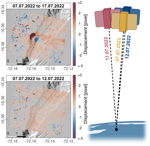
This study investigates the use of optical PlanetScope data for offset tracking of the Earth's surface movement. We found that co-registration accuracy is locally degraded when outdated elevation models are used for orthorectification. To mitigate this bias, we propose to only correlate scenes acquired from common perspectives or base orthorectification on more up-to-date elevation models generated from PlanetScope data alone. This enables a more detailed analysis of landslide dynamics.
Marin Kneib, Patrick Wagnon, Laurent Arnaud, Louise Balmas, Olivier Laarman, Bruno Jourdain, Amaury Dehecq, Emmanuel Lemeur, Fanny Brun, Andrea Kneib-Walter, Ilaria Santin, Laurane Charrier, Thierry Faug, Giulia Mazzotti, Antoine Rabatel, Delphine Six, and Daniel Farinotti
The Cryosphere, 20, 5327–5344, https://doi.org/10.5194/tc-20-5327-2026, https://doi.org/10.5194/tc-20-5327-2026, 2026
Short summary
Short summary
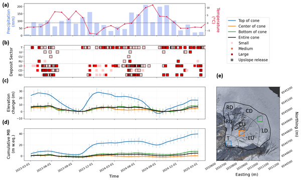
Avalanches are vital for glacier survival, yet their impact is difficult to quantify. We used low-cost cameras and drones to monitor an avalanche cone in the French Alps for two years. By accounting for ice flow, we found that avalanches can deposit 30 meters of snow annually – 50 times more than normal snowfall. This high-frequency data reveals that these cones fill until reaching a specific steepness, after which new snow slides further down to the base.
Sherilyn C. Fritz, André O. Sawakuchi, Anders Noren, Paul A. Baker, Cleverson Silva, Carlos Jaramillo, Renato Paes de Almeida, Liliane Janikian, Isaac Salém Bezerra, Marcos Barbosa, Dailson Bertassoli, Rain Blankenship, Cristiano M. Chiessi, Sarah J. Feakins, Maria da Glória Garcia, Cécile Gautheron, Brian Grivna, Gelvam Hartmann, Cindy Kunkel, André Marconato, Angela Martinez, Sebastian G. Marulanda, Carlos Eduardo M. Mazoca, Francisco R. Negri, Mauricio Parra, Werner E. Piller, Fabiano N. Pupim, Victor Salgado, Rachel T. So, Priscila Emerich Souza, Elena Stiles, Caroline A. E. Strömberg, Siu Mui Tsai, Ingo Wahnfried, Josh West, Marc-Élie Adaimé, Jhon Afonso, Thomas Kenji Akabane, Camila Eliza Althaus, Carlos D'Apolito, Kleiton R. Araújo, Roney da Silva de Azevedo Júnior, Jessica Barcellos, Tacio Bicudo, Giovanni Bogota, Bodo Bookhagen, Caio Breda, Alderlene Pimentel de Brito, Francy Carvajal, Daniel Antunes Coppi, Carolina Barbosa Leite da Cruz, Felipe Torres Figueiredo, Kate Freeman, Pedro Victor Oliveira Gomes, Martin Gross, Emma Hartke, Katja Heeschen, William Mozart Henrichs, Leonardo Henrique, Carina Hoorn, Brian K. Horton, Andrés Díaz-Jamamillo, Said Kamrani-Mehni, Fatima Leite, Lin Li, Rodrigo Ferreira de Lucena, Alastair Milne, Thomás Miranda, Marcelo Mota, Diana Ochoa, Vinicius de Lima Passos, Rafaela Maciel Lopes de Paula, Elisa Piispa, Angelo Plata Torres, Surangi W. Punyasena, Adriano Domingos dos Reis, Catherine Rigsby, Andrés F. Salazar Rios, Fernanda Costa Gonçalves Rodrigues, Raquel M. M. Romão, Ingrid C. Romero, Henrique O. Sawakuchi, Doug Schnurrenberger, Kristina Brady Shannon, Silane A. F. da Silva-Caminha, Clauses Sousa, Larissa Natsumi Tamura, Thomas Wiersberg, Helanlin Xiang, and Belén Zamudio
Sci. Dril., 35, 127–157, https://doi.org/10.5194/sd-35-127-2026, https://doi.org/10.5194/sd-35-127-2026, 2026
Short summary
Short summary
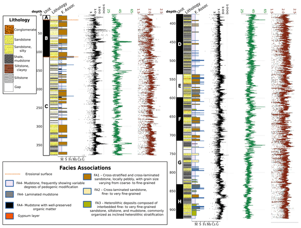
The Trans-Amazon Drilling Project seeks to reconstruct the origins of biodiversity in the world's largest and most diverse rain forest, and the roles of landscape changes driven by Andean uplift and global climate change in diversification. We provide a project overview and preliminary results from a drill core from the Acre Basin of western Brazil, which recovered an 860 m sequence that was deposited in a large river system and which will yield critical insights on evolutionary history.
Jing Zhang, Yang Lei, Laurane Charrier, Amaury Dehecq, Alex S. Gardner, Luke Copland, and Christine Dow
EGUsphere, https://doi.org/10.5194/egusphere-2026-2541, https://doi.org/10.5194/egusphere-2026-2541, 2026
This preprint is open for discussion and under review for The Cryosphere (TC).
Short summary
Short summary
Satellites can measure how fast glaciers move, which helps scientists understand ice loss and rising sea levels. However, these measurements have rarely been checked against ground-based observations on small mountain glaciers. We compared satellite-derived glacier speeds against precise ground measurements. The satellite data generally agreed well with ground observations. Our results help scientists use satellite glacier velocity data more reliably.
Jonas Kordt, Saptarshi Dey, Bodo Bookhagen, Georg Rugel, Johannes Lachner, Carlos Vivo-Vilches, Naveen Chauhan, and Rasmus Thiede
EGUsphere, https://doi.org/10.5194/egusphere-2026-2382, https://doi.org/10.5194/egusphere-2026-2382, 2026
Short summary
Short summary
Himalayan rivers respond to climatic forcing across multiple timescales. We investigate fluvial terraces along the Ravi and Suil rivers in the western Higher Himalaya using field work and various dating methods. Results show that past sediment accumulation and incision cycles can be linked to climatic oscillations. All terrace surfaces were affected by reworking, ~2–10 times more recent than deposition, and we propose that mass wasting and glacial lake outburst floods shaped these surfaces.
Vito Chan, Aljoscha Rheinwalt, and Bodo Bookhagen
Earth Surf. Dynam., 14, 391–416, https://doi.org/10.5194/esurf-14-391-2026, https://doi.org/10.5194/esurf-14-391-2026, 2026
Short summary
Short summary
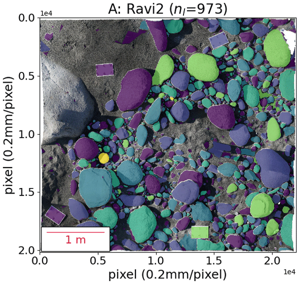
OrthoSAM is a new method that uses Segment Anything Model (SAM) to automatically identify and outline individual pebbles in high-resolution aerial images. OrthoSAM divides large photos into smaller sections that SAM can process effectively, and it improves the way to tell SAM where to look for objects. It uses a multi-resolution approach to handle different sizes, and it can be used to determine the distribution. Tests with computer-generated images and field data show that it is very precise.
Laurane Charrier, Nathan Lioret, Fanny Brun, Amaury Dehecq, Romain Millan, Anuar Togaibekov, Andrea Walpersdorf, Diego Cusicanqui, and Antoine Rabatel
EGUsphere, https://doi.org/10.5194/egusphere-2026-946, https://doi.org/10.5194/egusphere-2026-946, 2026
Short summary
Short summary
Sub-annual glacier surface velocity derived from remote sensing images are receiving increasing attention. In the meantime, systematic seasonal errors (i.e. biases) have been reported in time series derived from optical images on various landforms, such as landslides or dunes. The extent to which such biases affect glacier velocity maps remains poorly investigated. Here, we propose characterizing the amplitude and spatial distribution of these seasonal biases.
Laurane Charrier, Amaury Dehecq, Lei Guo, Fanny Brun, Romain Millan, Nathan Lioret, Luke Copland, Nathan Maier, Christine Dow, and Paul Halas
The Cryosphere, 19, 4555–4583, https://doi.org/10.5194/tc-19-4555-2025, https://doi.org/10.5194/tc-19-4555-2025, 2025
Short summary
Short summary
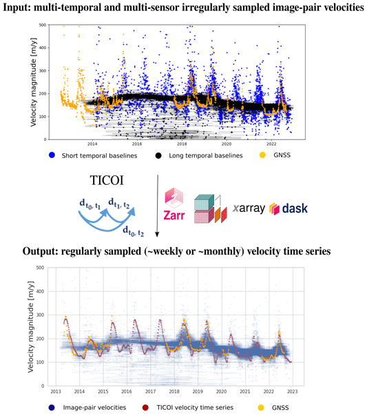
While global annual glacier velocities are openly accessible, sub-annual velocity time series are still lacking. This hinders our ability to understand flow processes and the integration of these observations in numerical models. We introduce an open source Python package called TICOI (Temporal Inversion using linear Combinations of Observations, and Interpolation) to fuse multi-temporal and multi-sensor image-pair velocities produced by different processing chains to produce standardized sub-annual velocity products.
Aljoscha Rheinwalt, Benjamin Purinton, and Bodo Bookhagen
Earth Surf. Dynam., 13, 923–940, https://doi.org/10.5194/esurf-13-923-2025, https://doi.org/10.5194/esurf-13-923-2025, 2025
Short summary
Short summary
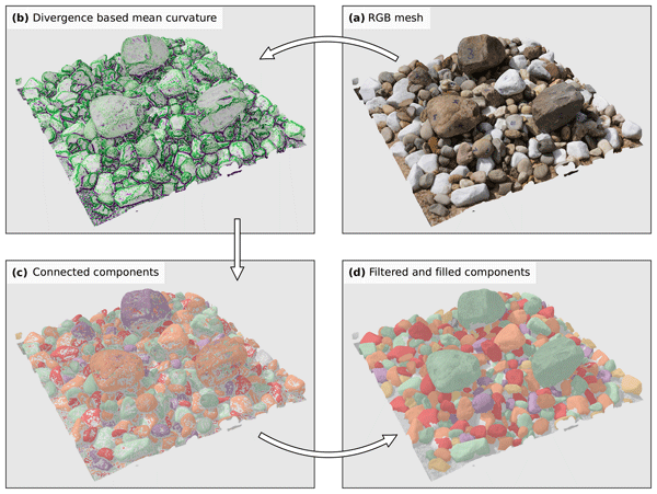
Our study presents a computer-based method to detect and measure pebbles in 3D models reconstructed from camera photos. We tested it in a controlled setup and achieved 98 % accuracy in detecting pebbles. Unlike traditional 2D methods, our approach provides full 3D size and orientation data. This improves sediment analysis and riverbed studies by offering more precise measurements. Our work highlights the potential of 3D modeling for studying natural surfaces.
Natalie Lützow, Bretwood Higman, Martin Truffer, Bodo Bookhagen, Friedrich Knuth, Oliver Korup, Katie E. Hughes, Marten Geertsema, John J. Clague, and Georg Veh
The Cryosphere, 19, 1085–1102, https://doi.org/10.5194/tc-19-1085-2025, https://doi.org/10.5194/tc-19-1085-2025, 2025
Short summary
Short summary
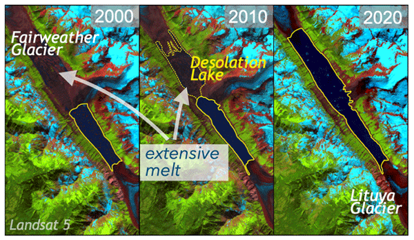
As the atmosphere warms, thinning glacier dams impound smaller lakes at their margins. Yet, some lakes deviate from this trend and have instead grown over time, increasing the risk of glacier floods to downstream populations and infrastructure. In this article, we examine the mechanisms behind the growth of an ice-dammed lake in Alaska. We find that the growth in size and outburst volumes is more controlled by glacier front downwaste than by overall mass loss over the entire glacier surface.
Ariane Mueting and Bodo Bookhagen
Earth Surf. Dynam., 12, 1121–1143, https://doi.org/10.5194/esurf-12-1121-2024, https://doi.org/10.5194/esurf-12-1121-2024, 2024
Short summary
Short summary
This study investigates the use of optical PlanetScope data for offset tracking of the Earth's surface movement. We found that co-registration accuracy is locally degraded when outdated elevation models are used for orthorectification. To mitigate this bias, we propose to only correlate scenes acquired from common perspectives or base orthorectification on more up-to-date elevation models generated from PlanetScope data alone. This enables a more detailed analysis of landslide dynamics.
Marin Kneib, Amaury Dehecq, Fanny Brun, Fatima Karbou, Laurane Charrier, Silvan Leinss, Patrick Wagnon, and Fabien Maussion
The Cryosphere, 18, 2809–2830, https://doi.org/10.5194/tc-18-2809-2024, https://doi.org/10.5194/tc-18-2809-2024, 2024
Short summary
Short summary
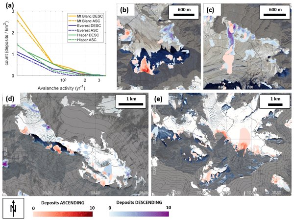
Avalanches are important for the mass balance of mountain glaciers, but few data exist on where and when they occur and which glaciers they affect the most. We developed an approach to map avalanches over large glaciated areas and long periods of time using satellite radar data. The application of this method to various regions in the Alps and High Mountain Asia reveals the variability of avalanches on these glaciers and provides key data to better represent these processes in glacier models.
L. Charrier, T. di Martino, E. Colin Koeniguer, F. Weissgerber, and A. Plyer
Int. Arch. Photogramm. Remote Sens. Spatial Inf. Sci., XLIII-B3-2022, 1309–1316, https://doi.org/10.5194/isprs-archives-XLIII-B3-2022-1309-2022, https://doi.org/10.5194/isprs-archives-XLIII-B3-2022-1309-2022, 2022
L. Charrier, Y. Yan, E. Colin Koeniguer, J. Mouginot, R. Millan, and E. Trouvé
ISPRS Ann. Photogramm. Remote Sens. Spatial Inf. Sci., V-3-2022, 311–318, https://doi.org/10.5194/isprs-annals-V-3-2022-311-2022, https://doi.org/10.5194/isprs-annals-V-3-2022-311-2022, 2022
Cited articles
Aati, S., Avouac, J.-P., Rupnik, E., and Deseilligny, M.-P.: Potential and Limitation of PlanetScope Images for 2-D and 3-D Earth Surface Monitoring With Example of Applications to Glaciers and Earthquakes, IEEE T. Geosci. Remote, 60, 1–19, https://doi.org/10.1109/TGRS.2022.3215821, 2022. a
Anderson, K. S., Hansen, C. W., Holmgren, W. F., Jensen, A. R., Mikofski, M. A., and Driesse, A.: pvlib python: 2023 project update, Journal of Open Source Software, 8, 5994, https://doi.org/10.21105/joss.05994, 2023. a
Angillieri, M. Y. E., Perucca, L., and Vargas, N.: Spatial and temporal analysis of debris flow occurrence in three adjacent basins of the western margin of Grande River: Quebrada de Humahuaca, Jujuy, Argentina, Geogr. Ann. A, 102, 83–103, https://doi.org/10.1080/04353676.2020.1744075, 2020. a, b, c, d, e, f
Antoine, S. L. and Liu, Z.: Impact of Optical Imagery and Topography Data Resolution on the Measurement of Surface Fault Displacement Using Sub-Pixel Image Correlation, Earth and Space Science, 12, e2024EA003660, https://doi.org/10.1029/2024EA003660, 2025. a, b, c
Berardino, P., Fornaro, G., Lanari, R., and Sansosti, E.: A new algorithm for surface deformation monitoring based on small baseline differential SAR interferograms, IEEE T. Geosci. Remote, 40, 2375–2383, https://doi.org/10.1109/TGRS.2002.803792, 2002. a
Beyer, R. A., Alexandrov, O., and McMichael, S.: The Ames Stereo Pipeline: NASA's open source software for deriving and processing terrain data, Earth and Space Science, 5, https://doi.org/10.1029/2018EA000409, 2018. a, b
Blöthe, J., Falaschi, D., Vivero, S., and Tadono, T.: Rock Glacier Kinematics in the Valles Calchaquíes Region, Northwestern Argentina, From Multi-Temporal Aerial and Satellite Imagery (1968–2023), Permafrost Periglac., 36, 123–136, https://doi.org/10.1002/ppp.2260, 2025. a
Bookhagen, B. and Strecker, M. R.: Orographic barriers, high-resolution TRMM rainfall, and relief variations along the eastern Andes, Geophys. Res. Lett., 35, https://doi.org/10.1029/2007GL032011, 2008. a
Charrier, L., Yan, Y., Colin Koeniguer, E., Mouginot, J., Millan, R., and Trouvé, E.: FUSION OF MULTI-TEMPORAL AND MULTI-SENSOR ICE VELOCITY OBSERVATIONS, ISPRS Ann. Photogramm. Remote Sens. Spatial Inf. Sci., V-3-2022, 311–318, https://doi.org/10.5194/isprs-annals-V-3-2022-311-2022, 2022a. a
Charrier, L., Yan, Y., Koeniguer, E. C., Leinss, S., and Trouvé, E.: Extraction of Velocity Time Series With an Optimal Temporal Sampling From Displacement Observation Networks, IEEE T. Geosci. Remote, 60, 1–10, https://doi.org/10.1109/TGRS.2021.3128289, 2022b. a, b, c, d
Charrier, L., Yan, Y., Trouvé, E., Koeniguer, E. C., Mouginot, J., and Millan, R.: Fusion of Multitemporal Multisensor Velocities Using Temporal Closure of Fractions of Displacements, IEEE Geosci. Remote S., 19, 1–5, https://doi.org/10.1109/LGRS.2022.3227413, 2022c. a, b, c
Crameri, F., Shephard, G., and Heron, P.: The misuse of colour in science communication, Nat. Commun., 11, https://doi.org/10.1038/s41467-020-19160-7, 2020. a
Dehecq, A., Gourmelen, N., and Trouve, E.: Deriving large-scale glacier velocities from a complete satellite archive: Application to the Pamir–Karakoram–Himalaya, Remote Sens. Environ., 162, 55–66, https://doi.org/10.1016/j.rse.2015.01.031, 2015. a, b
Dille, A., Kervyn, F., Handwerger, A. L., d'Oreye, N., Derauw, D., Mugaruka Bibentyo, T., Samsonov, S., Malet, J.-P., Kervyn, M., and Dewitte, O.: When image correlation is needed: Unravelling the complex dynamics of a slow-moving landslide in the tropics with dense radar and optical time series, Remote Sens. Environ., 258, 112402, https://doi.org/10.1016/j.rse.2021.112402, 2021. a
Ding, C., Zhang, L., Liao, M., Feng, G., Dong, J., Ao, M., and Yu, Y.: Quantifying the spatio-temporal patterns of dune migration near Minqin Oasis in northwestern China with time series of Landsat-8 and Sentinel-2 observations, Remote Sens. Environ., 236, 111498, https://doi.org/10.1016/j.rse.2019.111498, 2020. a, b, c
Ding, C., Feng, G., Liao, M., Tao, P., Zhang, L., and Xu, Q.: Displacement history and potential triggering factors of Baige landslides, China revealed by optical imagery time series, Remote Sens. Environ., 254, 112253, https://doi.org/10.1016/j.rse.2020.112253, 2021. a, b, c, d
Doin, M.-P., Lodge, F., Guillaso, S., Jolivet, R., Lasserre, C., Ducret, G., Grandin, R., Pathier, E., and Pinel, V.: Presentation of the Small Baselin NSBAS Processing Chain on a Case Example: The Etan Deformation Monitoring from 2003 to 2010 Using Envisat Data, in: Fringe Symposium, https://ens.hal.science/hal-02185213/ (last access: 26 September 2026), 2011. a
Earth Resources Observation and Science (EROS) Center: Landsat 4-5 Thematic Mapper Level-1, Collection 2, https://doi.org/10.5066/P9IAXOVV, 2020. a
European Space Agency: Copernicus Global Digital Elevation Model, OpenTopography, https://doi.org/10.5069/G9028PQB, 2024. a
Falaschi, D., Castro, M., Masiokas, M., Tadono, T., and Ahumada, A. L.: Rock Glacier Inventory of the Valles Calchaquíes Region (∼ 25° S), Salta, Argentina, Derived from ALOS Data, Permafrost Periglac., 25, 69–75, https://doi.org/10.1002/ppp.1801, 2014. a
Hadhri, H., Vernier, F., Atto, A. M., and Trouvé, E.: Time-lapse optical flow regularization for geophysical complex phenomena monitoring, ISPRS J. Photogramm., 150, 135–156, https://doi.org/10.1016/j.isprsjprs.2019.02.007, 2019. a
Handwerger, A. L., Roering, J. J., and Schmidt, D. A.: Controls on the seasonal deformation of slow-moving landslides, Earth Planet. Sc. Lett., 377–378, 239–247, https://doi.org/10.1016/j.epsl.2013.06.047, 2013. a, b
Handwerger, A. L., Fielding, E. J., Huang, M.-H., Bennett, G. L., Liang, C., and Schulz, W. H.: Widespread Initiation, Reactivation, and Acceleration of Landslides in the Northern California Coast Ranges due to Extreme Rainfall, J. Geophys. Res.-Earth, 124, 1782–1797, https://doi.org/10.1029/2019JF005035, 2019a. a, b, c
Handwerger, A. L., Huang, M.-H., Fielding, E. J., Booth, A. M., and Bürgmann, R.: A shift from drought to extreme rainfall drives a stable landslide to catastrophic failure, Sci. Rep., 9, 1569, https://doi.org/10.1038/s41598-018-38300-0, 2019b. a
Hersbach, H., Bell, B., Berrisford, P., Hirahara, S., Horányi, A., Muñoz-Sabater, J., Nicolas, J., Peubey, C., Radu, R., Schepers, D., Simmons, A., Soci, C., Abdalla, S., Abellan, X., Balsamo, G., Bechtold, P., Biavati, G., Bidlot, J., Bonavita, M., De Chiara, G., Dahlgren, P., Dee, D., Diamantakis, M., Dragani, R., Flemming, J., Forbes, R., Fuentes, M., Geer, A., Haimberger, L., Healy, S., Hogan, R. J., Hólm, E., Janisková, M., Keeley, S., Laloyaux, P., Lopez, P., Lupu, C., Radnoti, G., de Rosnay, P., Rozum, I., Vamborg, F., Villaume, S., and Thépaut, J.-N.: The ERA5 global reanalysis, Q. J. Roy. Meteor. Soc., 146, 1999–2049, https://doi.org/10.1002/qj.3803, 2020. a, b
Hilley, G. E., Bürgmann, R., Ferretti, A., Novali, F., and Rocca, F.: Dynamics of Slow-Moving Landslides from Permanent Scatterer Analysis, Science, 304, 1952–1955, https://doi.org/10.1126/science.1098821, 2004. a
Hollingsworth, J., Ye, L., and Avouac, J.-P.: Dynamically triggered slip on a splay fault in the Mw 7.8, 2016 Kaikoura (New Zealand) earthquake, Geophys. Res. Lett., 44, 3517–3525, https://doi.org/10.1002/2016GL072228, 2017. a, b
Hopquin, C., Gayer, E., Michon, L., Lucas, A., Smittarello, D., d'Oreye, N., and Villeneuve, N.: Unveiling tropical slow-moving landslide response to seasonality and extreme meteorological events using a combination of InSAR and optical imagery: The case study of Grand Eboulis (Réunion island), Geomorphology, 489, 109965, https://doi.org/10.1016/j.geomorph.2025.109965, 2025. a
Huffman, G. J., Stocker, E. F., Bolvin, D. T., Nelkin, E. J., and Tan, J.: GPM IMERG Final Precipitation L3 Half Hourly 0.1 degree × 0.1 degree V07, Goddard Earth Sciences Data and Information Services Center (GES DISC), https://doi.org/10.5067/GPM/IMERG/3B-HH/07, 2023. a, b
Lacroix, P., Bièvre, G., Pathier, E., Kniess, U., and Jongmans, D.: Use of Sentinel-2 images for the detection of precursory motions before landslide failures, Remote Sens. Environ., 215, 507–516, https://doi.org/10.1016/j.rse.2018.03.042, 2018. a, b, c
Lacroix, P., Handwerger, A., and Bièvre, G.: Life and death of slow-moving landslides, Nat. Rev. Earth Environ., 1, https://doi.org/10.1038/s43017-020-0072-8, 2020. a
Leprince, S., Ayoub, F., Klinger, Y., and Avouac, J.-P.: Co-Registration of Optically Sensed Images and Correlation (COSI-Corr): an operational methodology for ground deformation measurements, in: 2007 IEEE International Geoscience and Remote Sensing Symposium, 1943–1946, https://doi.org/10.1109/IGARSS.2007.4423207, 2007. a
Moreiras, S. M. and Coronato, A.: Landslide Processes in Argentina, in: Natural Hazards and Human-Exacerbated Disasters in Latin America, edited by: Latrubesse, E. M., vol. 13 of Developments in Earth Surface Processes, Elsevier, 301–332, https://doi.org/10.1016/S0928-2025(08)10015-3, 2009. a
Mueting, A., Charrier, L., and Bookhagen, B.: UP-RS-ESP/timeseries_inversion: v0.1.0 (Version v0.1.0), Zenodo [code], https://doi.org/10.5281/zenodo.22757225, 2026. a
Provost, F., Michéa, D., Malet, J.-P., Boissier, E., Pointal, E., Stumpf, A., Pacini, F., Doin, M.-P., Lacroix, P., Proy, C., and Bally, P.: Terrain deformation measurements from optical satellite imagery: The MPIC-OPT processing services for geohazards monitoring, Remote Sens. Environ., 274, 112949, https://doi.org/10.1016/j.rse.2022.112949, 2022. a, b, c, d, e, f
Purinton, B. and Bookhagen, B.: Measuring decadal vertical land-level changes from SRTM-C (2000) and TanDEM-X (∼ 2015) in the south-central Andes, Earth Surf. Dynam., 6, 971–987, https://doi.org/10.5194/esurf-6-971-2018, 2018. a
Rodríguez Fernández, R., Heredia, N., Seggiaro, R. E., and González, M. A.: Estructura andina de la Cordillera Oriental en el área de la Quebrada de Humahuaca, Provincia de Jujuy, NO de Argentina, Trabajos De Geología, 21, 321–333, http://reunido.uniovi.es/index.php/TDG/article/view/2905 (last access: 26 September 2026), 1999. a, b, c
Savi, S., Schildgen, T. F., Tofelde, S., Wittmann, H., Scherler, D., Mey, J., Alonso, R. N., and Strecker, M. R.: Climatic controls on debris-flow activity and sediment aggradation: The Del Medio fan, NW Argentina, J. Geophys. Res.-Earth, 121, 2424–2445, https://doi.org/10.1002/2016JF003912, 2016. a, b, c
Scherler, D., Leprince, S., and Strecker, M. R.: Glacier-surface velocities in alpine terrain from optical satellite imagery – Accuracy improvement and quality assessment, Remote Sens. Environ., 112, 3806–3819, https://doi.org/10.1016/j.rse.2008.05.018, 2008. a
Sreejith, K. M., Jasir, M. C. M., Sunil, P. S., Rose, M. S., Saji, A. P., Agrawal, R., Bushair, M. T., Vijay Kumar, K., and Desai, N. M.: Geodetic Evidence for Cascading Landslide Motion Triggered by Extreme Rain Events at Joshimath, NW Himalaya, Geophys. Res. Lett., 51, e2023GL106427, https://doi.org/10.1029/2023GL106427, 2024. a
Stumpf, A., Malet, J.-P., Allemand, P., and Ulrich, P.: Surface reconstruction and landslide displacement measurements with Pléiades satellite images, ISPRS J. Photogramm., 95, 1–12, https://doi.org/10.1016/j.isprsjprs.2014.05.008, 2014. a
Uhlemann, S., Chambers, J., Wilkinson, P., Maurer, H., Merritt, A., Meldrum, P., Kuras, O., Gunn, D., Smith, A., and Dijkstra, T.: Four-dimensional imaging of moisture dynamics during landslide reactivation, J. Geophys. Res.-Earth, 122, 398–418, https://doi.org/10.1002/2016JF003983, 2017. a
U.S. Geological Survey: Search Earthquake Catalog, https://earthquake.usgs.gov/earthquakes/search/ (last access: 4 October 2025), 2025. a
Van Wyk de Vries, M., Bhushan, S., Jacquemart, M., Deschamps-Berger, C., Berthier, E., Gascoin, S., Shean, D. E., Shugar, D. H., and Kääb, A.: Pre-collapse motion of the February 2021 Chamoli rock–ice avalanche, Indian Himalaya, Nat. Hazards Earth Syst. Sci., 22, 3309–3327, https://doi.org/10.5194/nhess-22-3309-2022, 2022. a
Xue, C., Chen, K., Tang, H., and Liu, P.: Heavy rainfall drives slow-moving landslide in Mazhe Village, Enshi to a catastrophic collapse on 21 July 2020, Landslides, 19, 177–186, https://doi.org/10.1007/s10346-021-01782-7, 2022. a
Short summary
Slow-moving landslides respond to seasonal climate variations, but displacement time series from optical satellite imagery often contain illumination and shadow related biases that obscure true signals. This study assesses methods to mitigate these errors and reveals kinematic changes and controlling factors of a large slow-moving landslide in the Argentinean Andes.
Slow-moving landslides respond to seasonal climate variations, but displacement time series from...


