
Articles | Volume 14, issue 6
https://doi.org/10.5194/esurf-14-887-2026
© Author(s) 2026. This work is distributed under
the Creative Commons Attribution 4.0 License.
the Creative Commons Attribution 4.0 License.
https://doi.org/10.5194/esurf-14-887-2026
© Author(s) 2026. This work is distributed under
the Creative Commons Attribution 4.0 License.
the Creative Commons Attribution 4.0 License.
Research article
| 
17 Nov 2026
Research article |
| 17 Nov 2026
| 17 Nov 2026
A gradual shift in channel dominance on the Karnali fluvial fan in the Himalayan Terai

Faculty of Civil Engineering and Geosciences, Delft University of Technology, Delft, the Netherlands
Astrid Blom
Faculty of Civil Engineering and Geosciences, Delft University of Technology, Delft, the Netherlands
Mathieu Roebroeck
Faculty of Civil Engineering and Geosciences, Delft University of Technology, Delft, the Netherlands
Marijn Wolf
Faculty of Civil Engineering and Geosciences, Delft University of Technology, Delft, the Netherlands
Thom Bogaard
Faculty of Civil Engineering and Geosciences, Delft University of Technology, Delft, the Netherlands
Related authors
No articles found.
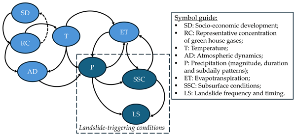
Daniel Camilo Roman Quintero, Ruud van der Ent, Thom Bogaard, and Roberto Greco
Nat. Hazards Earth Syst. Sci., 26, 3723–3739, https://doi.org/10.5194/nhess-26-3723-2026, https://doi.org/10.5194/nhess-26-3723-2026, 2026
Short summary
Short summary
We present a framework linking projected rainfall with hydro-mechanical processes to assess landslide occurrences in a Mediterranean area, under RCP4.5 and RCP8.5. Despite generally drier soils, landslide frequency rises because shifts in the timing and intensity of rainfall, altering antecedent soil moisture during triggering events. This counterintuitive result highlights the importance of rainfall patterns in slope stability and informs climate-risk assessment and adaptation planning.
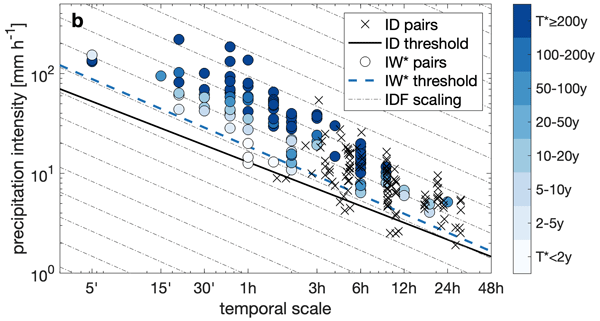
Francesco Marra, Eleonora Dallan, Marco Borga, Roberto Greco, and Thom Bogaard
Nat. Hazards Earth Syst. Sci., 25, 5055–5061, https://doi.org/10.5194/nhess-25-5055-2025, https://doi.org/10.5194/nhess-25-5055-2025, 2025
Short summary
Short summary
We highlight an important conceptual difference between the duration used in intensity-duration thresholds and the duration used in the intensity-duration-frequency curves that has been overlooked by the landslide literature so far.
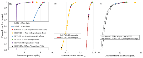
Benjamin B. Mirus, Thom Bogaard, Roberto Greco, and Manfred Stähli
Nat. Hazards Earth Syst. Sci., 25, 169–182, https://doi.org/10.5194/nhess-25-169-2025, https://doi.org/10.5194/nhess-25-169-2025, 2025
Short summary
Short summary
Early warning of increased landslide potential provides situational awareness to reduce landslide-related losses from major storm events. For decades, landslide forecasts relied on rainfall data alone, but recent research points to the value of hydrologic information for improving predictions. In this paper, we provide our perspectives on the value and limitations of integrating subsurface hillslope hydrologic monitoring data and mathematical modeling for more accurate landslide forecasts.
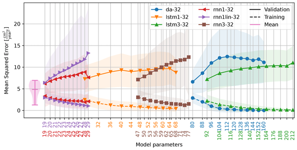
Adriaan L. van Natijne, Thom A. Bogaard, Thomas Zieher, Jan Pfeiffer, and Roderik C. Lindenbergh
Nat. Hazards Earth Syst. Sci., 23, 3723–3745, https://doi.org/10.5194/nhess-23-3723-2023, https://doi.org/10.5194/nhess-23-3723-2023, 2023
Short summary
Short summary
Landslides are one of the major weather-related geohazards. To assess their potential impact and design mitigation solutions, a detailed understanding of the slope is required. We tested if the use of machine learning, combined with satellite remote sensing data, would allow us to forecast deformation. Our results on the Vögelsberg landslide, a deep-seated landslide near Innsbruck, Austria, show that the formulation of such a machine learning system is not as straightforward as often hoped for.
Yi Luo, Jiaming Zhang, Zhi Zhou, Juan P. Aguilar-Lopez, Roberto Greco, and Thom Bogaard
Hydrol. Earth Syst. Sci., 27, 783–808, https://doi.org/10.5194/hess-27-783-2023, https://doi.org/10.5194/hess-27-783-2023, 2023
Short summary
Short summary
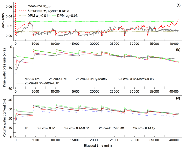
This paper describes an experiment and modeling of the hydrological response of desiccation cracks under long-term wetting–drying cycles. We developed a new dynamic dual-permeability model to quantify the dynamic evolution of desiccation cracks and associated preferential flow and moisture distribution. Compared to other models, the dynamic dual-permeability model could describe the experimental data much better, but it also provided an improved description of the underlying physics.
Judith Uwihirwe, Alessia Riveros, Hellen Wanjala, Jaap Schellekens, Frederiek Sperna Weiland, Markus Hrachowitz, and Thom A. Bogaard
Nat. Hazards Earth Syst. Sci., 22, 3641–3661, https://doi.org/10.5194/nhess-22-3641-2022, https://doi.org/10.5194/nhess-22-3641-2022, 2022
Short summary
Short summary
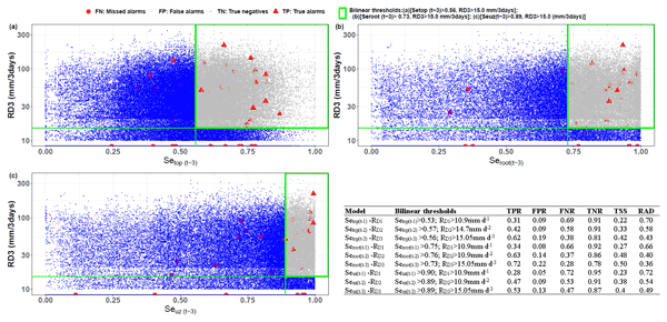
This study compared gauge-based and satellite-based precipitation products. Similarly, satellite- and hydrological model-derived soil moisture was compared to in situ soil moisture and used in landslide hazard assessment and warning. The results reveal the cumulative 3 d rainfall from the NASA-GPM to be the most effective landslide trigger. The modelled antecedent soil moisture in the root zone was the most informative hydrological variable for landslide hazard assessment and warning in Rwanda.

Jan Pfeiffer, Thomas Zieher, Jan Schmieder, Thom Bogaard, Martin Rutzinger, and Christoph Spötl
Nat. Hazards Earth Syst. Sci., 22, 2219–2237, https://doi.org/10.5194/nhess-22-2219-2022, https://doi.org/10.5194/nhess-22-2219-2022, 2022
Short summary
Short summary
The activity of slow-moving deep-seated landslides is commonly governed by pore pressure variations within the shear zone. Groundwater recharge as a consequence of precipitation therefore is a process regulating the activity of landslides. In this context, we present a highly automated geo-statistical approach to spatially assess groundwater recharge controlling the velocity of a deep-seated landslide in Tyrol, Austria.
Judith Uwihirwe, Markus Hrachowitz, and Thom Bogaard
Nat. Hazards Earth Syst. Sci., 22, 1723–1742, https://doi.org/10.5194/nhess-22-1723-2022, https://doi.org/10.5194/nhess-22-1723-2022, 2022
Short summary
Short summary
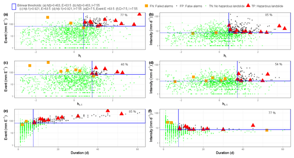
This research tested the value of regional groundwater level information to improve landslide predictions with empirical models based on the concept of threshold levels. In contrast to precipitation-based thresholds, the results indicated that relying on threshold models exclusively defined using hydrological variables such as groundwater levels can lead to improved landslide predictions due to their implicit consideration of long-term antecedent conditions until the day of landslide occurrence.
Punpim Puttaraksa Mapiam, Monton Methaprayun, Thom Bogaard, Gerrit Schoups, and Marie-Claire Ten Veldhuis
Hydrol. Earth Syst. Sci., 26, 775–794, https://doi.org/10.5194/hess-26-775-2022, https://doi.org/10.5194/hess-26-775-2022, 2022
Short summary
Short summary
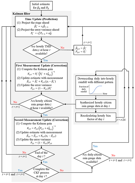
The density of rain gauge networks plays an important role in radar rainfall bias correction. In this work, we aimed to assess the extent to which daily rainfall observations from a dense network of citizen scientists improve the accuracy of hourly radar rainfall estimates in the Tubma Basin, Thailand. Results show that citizen rain gauges significantly enhance the performance of radar rainfall bias adjustment up to a range of about 40 km from the center of the citizen rain gauge network.
Cited articles
Agarwal, R. P. and Bhoj, R.: Evolution of Kosi river fan, India: structural implications and geomorphic significance, Int. J. Remote Sens., 13, 1891–1901, https://doi.org/10.1080/01431169208904238, 1992. a
Baar, A. W., de Smit, J., Uijttewaal, W. S., and Kleinhans, M. G.: Sediment transport of fine sand to fine gravel on transverse bed slopes in rotating annular flume experiments, Water Resour. Res., 54, 19–45, https://doi.org/10.1002/2017WR020604, 2018. a
Bajracharya, A., Bajracharya, S., Shrestha, A., and Maharjan, S.: Climate change impact assessment on the hydrological regime of the Kaligandaki Basin, Nepal, Sci. Total Environ., 625, 837–848, https://doi.org/10.1016/j.scitotenv.2017.12.332, 2018. a, b
Biggs, H., Smart, G., Doyle, M., Eickelberg, N., Aberle, J., Randall, M., and Detert, M.: Surface velocity to depth-averaged velocity – a review of methods to estimate alpha and remaining challenges, Water, 15, 3711, https://doi.org/10.3390/w15213711, 2023. a
Bijlmakers, J., Griffioen, J., and Karssenberg, D.: Environmental drivers of spatio-temporal dynamics in floodplain vegetation: grasslands as habitat for megafauna in Bardia National Park (Nepal), Biogeosciences, 20, 1113–1144, https://doi.org/10.5194/bg-20-1113-2023, 2023. a
Blom, A., Chavarrías, V., Ferguson, R. I., and Viparelli, E.: Advance, retreat, and halt of abrupt gravel-sand transitions in alluvial rivers, Geophys. Res. Lett., 44, 9751–9760, https://doi.org/10.1002/2017GL074231, 2017. a, b
Bolla Pittaluga, M., Repetto, R., and Tubino, M.: Channel bifurcation in braided rivers: Equilibrium configurations and stability, Water Resour. Res., 39, https://doi.org/10.1029/2001WR001112, 2003. a
Bookhagen, B. and Burbank, D. W.: Toward a complete Himalayan hydrological budget: Spatiotemporal distribution of snowmelt and rainfall and their impact on river discharge, J. Geophys. Res.-Earth, 115, https://doi.org/10.1029/2009JF001426, 2010. a
Chakraborty, T., Kar, R., Ghosh, P., and Basu, S.: Kosi megafan: Historical records, geomorphology and the recent avulsion of the Kosi River, Quatern. Int., 227, 143–160, https://doi.org/10.1016/j.quaint.2009.12.002, 2010. a, b, c, d
Chamberlain, E. L., Goodbred, S. L., Steckler, M. S., Wallinga, J., Reimann, T., Akhter, S. H., Bain, R., Muktadir, G., Al Nahian, A., Rahman, F. M. A., Rahman, M., Seeber, L., and von Hagke, C.: Cascading hazards of a major Bengal basin earthquake and abrupt avulsion of the Ganges River, Nat. Commun., 15, 4975, https://doi.org/10.1038/s41467-024-47786-4, 2024. a
Chanchani, P., Lamichhane, B. R., Malla, S., Maurya, K., Bista, A., Warrier, R., Nair, S., Almeida, M., Ravi, R., Sharma, R., Dhakal, M., Yadav, S. P., Thapa, M., Jnawali, S. R., Pradhan, N. M. B., Subedi, N., Thapa, G. J., Yadav, H., Jhala, Y. V., Quereshi, Q., Vattakaven, J., and Borah, J.: Tigers of the transboundary Terai Arc Landscape: Status, distribution and movement in the Terai of India and Nepal, Tech. rep., National Tiger Conservation Authority, Government of India, and Department of National Park and Wildlife Conservation, Government of Nepal, https://doi.org/10.13140/2.1.2737.2808, 2014. a
Chowdhury, M. K., Blom, A., Ylla Arbós, C., and Schielen, R. M. J.: Climate-change projections of flow distribution across the Rhine delta, J. Geophys. Res.-Earth, 131, https://doi.org/10.1029/2025JF008705, 2026. a
Dadson, S. J., Hovius, N., Chen, H., Dade, W. B., Lin, J.-C., Hsu, M.-L., Lin, C.-W., Horng, M.-J., Chen, T.-C., Milliman, J., and Stark, C. P.: Earthquake-triggered increase in sediment delivery from an active mountain belt, Geology, 32, 733–736, https://doi.org/10.1130/G20639.1, 2004. a
Dahal, P., Shrestha, M. L., Panthi, J., and Pradhananga, D.: Modeling the future impacts of climate change on water availability in the Karnali River Basin of Nepal Himalaya, Environ. Res., 185, 109430, https://doi.org/10.1016/j.envres.2020.109430, 2020. a
DeCelles, P. G. and Cavazza, W.: A comparison of fluvial megafans in the Cordilleran (Upper Cretaceous) and modern Himalayan foreland basin systems, Geol. Soc. Am. Bull., 111, 1315–1334, https://doi.org/10.1130/0016-7606(1999)111<1315:ACOFMI>2.3.CO;2, 1999. a, b
Dingle, E. H., Attal, M., and Sinclair, H. D.: Abrasion-set limits on Himalayan gravel flux, Nature, 544, 471–474, https://doi.org/10.1038/nature22039, 2017. a, b, c, d
Dingle, E. H., Creed, M. J., Sinclair, H. D., Gautam, D., Gourmelen, N., Borthwick, A. G. L., and Attal, M.: Dynamic flood topographies in the Terai region of Nepal, Earth Surf. Proc. Land., 45, 3092–3102, https://doi.org/10.1002/esp.4953, 2020a. a
Dingle, E. H., Sinclair, H. D., Venditti, J. G., Attal, M., Kinnaird, T. C., Creed, M., Quick, L., Nittrouer, J. A., and Gautam, D.: Sediment dynamics across gravel-sand transitions: Implications for river stability and floodplain recycling, Geology, 48, 468–472, https://doi.org/10.1130/G46909.1, 2020b. a, b
Dingle, E. H., Kusack, K. M., and Venditti, J. G.: The gravel-sand transition and grain size gap in river bed sediments, Earth-Sci. Rev., 222, 103838, https://doi.org/10.1016/j.earscirev.2021.103838, 2021. a
Edmonds, D. A. and Slingerland, R. L.: Stability of delta distributary networks and their bifurcations, Water Resour. Res., 44, https://doi.org/10.1029/2008WR006992, 2008. a
European Space Agency: Copernicus Global Digital Elevation Model, distributed by OpenTopography [data set], https://doi.org/10.5069/G9028PQB, 2024. a
Friend, P. F. and Sinha, R.: Braiding and meandering parameters, Geological Society, London, Special Publications, 75, 105–111, https://doi.org/10.1144/GSL.SP.1993.075.01.05, 1993. a
Frings, R. M. and Kleinhans, M. G.: Complex variations in sediment transport at three large river bifurcations during discharge waves in the River Rhine, Sedimentology, 55, 1145–1171, https://doi.org/10.1111/j.1365-3091.2007.00940.x, 2008. a
Gautam, M. R. and Acharya, K.: Streamflow trends in Nepal, Hydrol. Sci. J., 57, 344–357, https://doi.org/10.1080/02626667.2011.637042, 2012. a
Gearon, J. H., Martin, H. K., DeLisle, C., Barefoot, E. A., Mohrig, D., Paola, C., and Edmonds, D. A.: Rules of river avulsion change downstream, Nature, 634, 91–95, https://doi.org/10.1038/s41586-024-07964-2, 2024. a
Geddes, A.: The alluvial morphology of the Indo-Gangetic Plain: Its mapping and geographical significance, Transactions and Papers (Institute of British Geographers), 253–276, https://doi.org/10.2307/621126, 1960. a, b, c
Ghimire, P.: Conservation status of Greater One-horned Rhinoceros (Rhinoceros unicornis) in Nepal: A review of current efforts and challenges, Grassroots Journal of Natural Resources, 3, 1–14, https://doi.org/10.33002/nr2581.6853.03011, 2020. a
Goswami, P. K. and Mishra, J. K.: Climatic and tectonic controls on the sedimentary processes of an alluvial fan of the western Ganga Plain, India, Geol. Mag., 150, 240–253, https://doi.org/10.1017/S0016756812000490, 2013. a
Gregory, K. J.: The human role in changing river channels, Geomorphology, 79, 172–191, https://doi.org/10.1016/j.geomorph.2006.06.018, 2006. a
Haddeland, I., Heinke, J., Biemans, H., Eisner, S., Flörke, M., Hanasaki, N., Konzmann, M., Ludwig, F., Masaki, Y., Schewe, J., Stacke, T., Tessler, Z. D., Wada, Y., and Wisser, D.: Global water resources affected by human interventions and climate change, P. Natl. Acad. Sci., 111, 3251–3256, https://doi.org/10.1073/pnas.1222475110, 2014. a
Hansford, M. R. and Plink-Björklund, P.: River discharge variability as the link between climate and fluvial fan formation, Geology, 48, 952–956, https://doi.org/10.1130/G47471.1, 2020. a
Hawker, L., Uhe, P., Paulo, L., Sosa, J., Savage, J., Sampson, C., and Neal, J.: A 30 m global map of elevation with forests and buildings removed, Environ. Res. Lett., 17, 024016, https://doi.org/10.1088/1748-9326/ac4d4f, 2022. a
Holbrook, J. and Schumm, S. A.: Geomorphic and sedimentary response of rivers to tectonic deformation: a brief review and critique of a tool for recognizing subtle epeirogenic deformation in modern and ancient settings, Tectonophysics, 305, 287–306, https://doi.org/10.1016/S0040-1951(99)00011-6, 1999. a
Hovius, N., Stark, C. P., and Allen, P. A.: Sediment flux from a mountain belt derived by landslide mapping, Geology, 25, 231–234, https://doi.org/10.1130/0091-7613(1997)025<0231:SFFAMB>2.3.CO;2, 1997. a
Ikeda, S., Yamasaka, M., and Chiyoda, M.: Bed topography and sorting in bends, J. Hydraul. Eng., 113, 190–204, https://doi.org/10.1061/(ASCE)0733-9429(1987)113:2(190), 1987. a
Immerzeel, W. W., Van Beek, L. P. H., and Bierkens, M. F. P.: Climate change will affect the Asian water towers, Science, 328, 1382–1385, https://doi.org/10.1126/science.1183188, 2010. a
Japan Aerospace Exploration Agency: ALOS World 3D 30 meter DEM. V3.2, Jan 2021, distributed by OpenTopography [data set], https://doi.org/10.5069/G94M92HB, 2021. a
Kafle, M. R.: Critical review and improvement of bank protection methods in Nepalese rivers, Journal of the Institute of Engineering, 16, 15–25, https://doi.org/10.3126/jie.v16i1.36530, 2021. a
Kayitesi, N. M., Guzha, A. C., and Mariethoz, G.: Impacts of land use land cover change and climate change on river hydro-morphology- a review of research studies in tropical regions, J. Hydrol., 615, 128702, https://doi.org/10.1016/j.jhydrol.2022.128702, 2022. a
Khanal, G., Suryawanshi, K. R., Awasthi, K. D., Dhakal, M., Subedi, N., Nath, D., Kandel, R. C., and Kelkar, N.: Irrigation demands aggravate fishing threats to river dolphins in Nepal, Biol. Conserv., 204, 386–393, https://doi.org/10.1016/j.biocon.2016.10.026, 2016. a, b, c, d
Khatiwada, K. R., Panthi, J., Shrestha, M. L., and Nepal, S.: Hydro-climatic variability in the Karnali River basin of Nepal Himalaya, Climate, 4, 17, https://doi.org/10.3390/cli4020017, 2016. a, b
Kleinhans, M. G., Ferguson, R. I., Lane, S. N., and Hardy, R. J.: Splitting rivers at their seams: bifurcations and avulsion, Earth Surf. Proc. Land., 38, 47–61, https://doi.org/10.1002/esp.3268, 2013. a
Leier, A. L., DeCelles, P. G., and Pelletier, J. D.: Mountains, monsoons, and megafans, Geology, 33, 289–292, https://doi.org/10.1130/G21228.1, 2005. a, b
Lin, G.-W.: Variations of fluvial sediment transport after large earthquakes: Field study in Taiwan catchments, Water, 10, https://doi.org/10.3390/w10121836, 2018. a
Lupker, M., Blard, P.-H., Lavé, J., France-Lanord, C., Leanni, L., Puchol, N., Charreau, J., and Bourlès, D.: 10Be-derived Himalayan denudation rates and sediment budgets in the Ganga basin, Earth Planet. Sci. Lett., 333, 146–156, https://doi.org/10.1016/j.epsl.2012.04.020, 2012. a
Lutz, A. F., Immerzeel, W. W., Shrestha, A. B., and Bierkens, M. F. P.: Consistent increase in High Asia's runoff due to increasing glacier melt and precipitation, Nat. Clim. Change, 4, 587–592, https://doi.org/10.1038/nclimate2237, 2014. a, b
Magilligan, F. J., Nislow, K. H., and Graber, B. E.: Scale-independent assessment of discharge reduction and riparian disconnectivity following flow regulation by dams, Geology, 31, 569–572, https://doi.org/10.1130/0091-7613(2003)031<0569:SAODRA>2.0.CO;2, 2003. a, b
Magilligan, F. J. and Nislow, K. H.: Changes in hydrologic regime by dams, Geomorphology, 71, 61–78, https://doi.org/10.1016/j.geomorph.2004.08.017, 2005. a
Mao, L.: The effects of flood history on sediment transport in gravel-bed rivers, Geomorphology, 322, 196–205, https://doi.org/10.1016/j.geomorph.2018.08.046, 2018. a
Marc, O., Behling, R., Andermann, C., Turowski, J. M., Illien, L., Roessner, S., and Hovius, N.: Long-term erosion of the Nepal Himalayas by bedrock landsliding: the role of monsoons, earthquakes and giant landslides, Earth Surf. Dynam., 7, 107–128, https://doi.org/10.5194/esurf-7-107-2019, 2019. a
Martin, H. K. and Edmonds, D. A.: Avulsion dynamics determine fluvial fan morphology in a cellular model, Geology, 51, 796–800, https://doi.org/10.1130/G51138.1, 2023. a
McFeeters, S. K.: The use of the Normalized Difference Water Index (NDWI) in the delineation of open water features, Int. J. Remote Sens., 17, 1425–1432, https://doi.org/10.1080/01431169608948714, 1996. a
Mendoza, A., Soto-Cortes, G., Priego-Hernandez, G., and Rivera-Trejo, F.: Historical description of the morphology and hydraulic behavior of a bifurcation in the lowlands of the Grijalva River Basin, Mexico, CATENA, 176, 343–351, https://doi.org/10.1016/j.catena.2019.01.033, 2019. a
NASA Shuttle Radar Topography Mission (SRTM): Shuttle Radar Topography Mission (SRTM) Global, distributed by OpenTopography [data set], https://doi.org/10.5069/G9445JDF, 2013. a
Oki, T. and Kanae, S.: Global hydrological cycles and world water resources, Science, 313, 1068–1072, https://doi.org/10.1126/science.1128845, 2006. a
Palmer, M. A., Liermann, C. A. R., Nilsson, C., Flörke, M., Alcamo, J., Lake, P. S., and Bond, N.: Climate change and the world's river basins: anticipating management options, Front. Ecol. Environ., 6, 81–89, https://doi.org/10.1890/060148, 2008. a
Paola, C., Parker, G., Seal, R., Sinha, S. K., Southard, J. B., and Wilcock, P. R.: Downstream fining by selective deposition in a laboratory flume, Science, 258, 1757–1760, https://doi.org/10.1126/science.258.5089.1757, 1992. a
Parker, G. and Andrews, E. D.: Sorting of bed load sediment by flow in meander bends, Water Resour. Res., 21, 1361–1373, https://doi.org/10.1029/WR021i009p01361, 1985. a
Parker, G. and Cui, Y.: The arrested gravel front: Stable gravel-sand transitions in rivers. Part 1: Simplified analytical solution, J. Hydraul. Res., 36, 75–100, https://doi.org/10.1080/00221689809498379, 1998. a
Parker, G., Paola, C., Whipple, K. X., and Mohrig, D.: Alluvial fans formed by channelized fluvial and sheet flow. I: Theory, J. Hydraul. Eng., 124, 985–995, https://doi.org/10.1061/(ASCE)0733-9429(1998)124:10(985), 1998. a
Pink, I., Reaney, S. M., Hardy, R. J., and Bovolo, C. I.: Increased rainfall-runoff drives flood hazard intensification in Central Himalayan river systems, Sci. Rep., 15, 42277, https://doi.org/10.1038/s41598-025-26815-2, 2025. a
Pokhrel, P., Griffioen, J., Bogaard, T. A., Kraaijenbrink, P. D. A., Fiddes, J., and Immerzeel, W. W.: Upstream hydrology and the importance of snowmelt in buffering droughts in the Karnali basin in Nepal, Front. Water, 7, https://doi.org/10.3389/frwa.2025.1720178, 2026. a
Pradhananga, S., Nepal, S., Kamal, S. K., and Hafeez, M.: Climate change will exacerbate seasonal flow variability in the Karnali River basin: Implications for water, energy, and agriculture sectors, Hydrol. Res., 56, 471–491, https://doi.org/10.2166/nh.2025.193, 2025. a
Quick, L., Creed, M. J., Sinclair, H. D., Attal, M., Borthwick, A. G. L., and Sinha, R.: Hyperconcentrated floods cause extreme gravel transport through the sandy rivers of the Gangetic Plains, Commun. Earth Environ., 4, 297, https://doi.org/10.1038/s43247-023-00953-9, 2023. a, b
Rakhal, B., Adhikari, T. R., Sharma, S., and Ghimire, G. R.: Assessment of channel shifting of Karnali Megafan in Nepal using remote sensing and GIS, Annals of GIS, 27, 177–188, https://doi.org/10.1080/19475683.2021.1871950, 2021. a, b, c
Rantz, S. E.: Measurement and computation of streamflow, Tech. Rep. 2175, U.S. G.P.O., https://doi.org/10.3133/wsp2175, 1982. a
Roebroeck, M. E.: Morphodynamics of the Karnali fluvial fan: An assessment of the effects of human interventions on the morphodynamics of an alluvial river using optical remote sensing data, Master's thesis, Delft University of Technology, http://resolver.tudelft.nl/uuid:a6c612ed-6670-49d1-8a27-382b21ec2eb8 (last access: 9 November 2026), 2022. a, b, c, d
Schielen, R. M. J. and Blom, A.: A reduced complexity model of a gravel-sand river bifurcation: Equilibrium states and their stability, Adv. Water Resour., 121, 9–21, https://doi.org/10.1016/j.advwatres.2018.07.010, 2018. a
Schmidt, J. C. and Wilcock, P. R.: Metrics for assessing the downstream effects of dams, Water Resour. Res., 44, https://doi.org/10.1029/2006WR005092, 2008. a
Shrestha, D. L. and Paudyal, G. N.: Water resources development planning in the Karnali river basin, Nepal, Int. J. Water Resour. D., 8, 195–203, https://doi.org/10.1080/07900629208722553, 1992. a
Singh, R. L.: India: A Regional Geography, National Geographical Society of India, Varasani, section XXII, OCLC: 185430179, 992 pp., 1971. a
Sinha, R. and Friend, P. F.: River systems and their sediment flux, Indo-Gangetic plains, Northern Bihar, India, Sedimentology, 41, 825–845, https://doi.org/10.1111/j.1365-3091.1994.tb01426.x, 1994. a
Sinha, R., Jain, V., Babu, G. P., and Ghosh, S.: Geomorphic characterization and diversity of the fluvial systems of the Gangetic Plains, Geomorphology, 70, 207–225, https://doi.org/10.1016/j.geomorph.2005.02.006, 2005. a, b, c
Sinha, R., Sripriyanka, K., Jain, V., and Mukul, M.: Avulsion threshold and planform dynamics of the Kosi River in North Bihar (India) and Nepal: a GIS framework, Geomorphology, 216, 157–170, https://doi.org/10.1016/j.geomorph.2014.03.035, 2014. a
Sinha, R., Gupta, A., Mishra, K., Tripathi, S., Nepal, S., Wahid, S. M., and Swarnkar, S.: Basin-scale hydrology and sediment dynamics of the Kosi river in the Himalayan foreland, J. Hydrol., 570, 156–166, https://doi.org/10.1016/j.jhydrol.2018.12.051, 2019. a
Sinha, R., Singh, S., Mishra, K., and Swarnkar, S.: Channel morphodynamics and sediment budget of the Lower Ganga River using a hydrogeomorphological approach, Earth Surf. Proc. Land., 48, 14–33, https://doi.org/10.1002/esp.5325, 2023. a
Slingerland, R. and Smith, N. D.: River avulsions and their deposits, Ann. Rev. Earth Planet. Sci., 32, 257–285, https://doi.org/10.1146/annurev.earth.32.101802.120201, 2004. a, b
Swarnkar, S., Mujumdar, P., and Sinha, R.: Modified hydrologic regime of upper Ganga basin induced by natural and anthropogenic stressors, Sci. Rep., 11, 19 491, https://doi.org/10.1038/s41598-021-98827-7, 2021. a
Sylvester, Z., Stockli, D. F., Howes, N., Roberts, K., Malkowski, M. A., Poros, Z., Martindale, R. C., and Bai, W.: Segmenteverygrain: A Python module for segmentation of grains in images, Journal of Open Source Software, 10, 7953, https://doi.org/10.21105/joss.07953, 2025. a
Thapa, K., Nepal, S., Thapa, G., Bhatta, S. R., and Wikramanayake, E.: Past, present and future conservation of the greater one-horned rhinoceros Rhinoceros unicornis in Nepal, Oryx, 47, 345–351, https://doi.org/10.1017/S0030605311001670, 2013. a
Thapa, K., Kelly, M. J., and Pradhan, N. M. B.: Elephant (Elephas maximus) temporal activity, distribution, and habitat use patterns on the tiger’s forgotten trails across the seasonally dry, subtropical, hilly Churia forests of Nepal, PLoS One, 14, https://doi.org/10.1371/journal.pone.0216504, 2019. a
Valenza, J. M., Edmonds, D. A., Hwang, T., and Roy, S.: Downstream changes in river avulsion style are related to channel morphology, Nat. Commun., 11, 2116, https://doi.org/10.1038/s41467-020-15859-9, 2020. a
Venkateswaran, K., Macclune, K., Dixit, K., Yadav, S., Maharjan, R., and Dugar, S.: Urgent case for recovery: what we can learn from the August 2014 Karnali River floods in Nepal, Tech. rep., Zurich Insurance Group Ltd and ISET-International, https://doi.org/10.13140/RG.2.1.1641.2003, 2015. a
Vericat, D., Batalla, R. J., and Garcia, C.: Breakup and reestablishment of the armour layer in a large gravel-bed river below dams: The lower Ebro, Geomorphology, 76, 122–136, https://doi.org/10.1016/j.geomorph.2005.10.005, 2006. a
Vörösmarty, C. J., Meybeck, M., Fekete, B., Sharma, K., Green, P., and Syvitski, J. P. M.: Anthropogenic sediment retention: major global impact from registered river impoundments, Glob. Planet. Change, 39, 169–190, https://doi.org/10.1016/S0921-8181(03)00023-7, 2003. a
Wang, Q., Wang, L., Wang, T., Yang, K., and Nie, R.: Experimental study on the critical breakup condition of a static armour layer, River Res. Appl., 37, 484–493, https://doi.org/10.1002/rra.3759, 2021. a
Wang, Z., De Vries, M., Fokkink, R., and Langerak, A.: Stability of river bifurcations in ID morphodynamic models, J. Hydraul. Res., 33, 739–750, https://doi.org/10.1080/00221689509498549, 1995. a
Wells, N. A. and Dorr, J. A.: Shifting of the Kosi River, northern India, Geology, 15, 204, https://doi.org/10.1130/0091-7613(1987)15<204:SOTKRN>2.0.CO;2, 1987. a, b, c, d
Wikramanayake, E. D., Dinerstein, E., Robinson, J. G., Karanth, U., Rabinowitz, A., Olson, D., Mathew, T., Hedao, P., Conner, M., Hemley, G., and Bolze, D.: An ecology-based method for defining priorities for large mammal conservation: The tiger as case study, Conserv. Biol., 12, 865–878, https://doi.org/10.1111/j.1523-1739.1998.96428.x, 1998. a, b
Wikramanayake, E. D., Manandhar, A., Bajimaya, S., Nepal, S., Thapa, G., and Thapa, K.: The Terai Arc Landscape: A tiger conservation success story in a human-dominated landscape, in: Tigers of the world, edited by: Tilson, R. and Nyhus, P. J., 163–173, William Andrew Publishing, https://doi.org/10.1016/B978-0-8155-1570-8.00010-4, 2010. a, b
Yadav, A., Boothroyd, R. J., Sambrook Smith, G. H., and Sen, S.: Morphological adjustments of the Yamuna River in the Himalayan foothills in response to natural and anthropogenic stresses, Hydrol. Proc., 37, https://doi.org/10.1002/hyp.14934, 2023. a
Short summary
The Karnali River in Himalayan Terai of Nepal has shifted from double to single branch since 2009. Likely triggered by a double-peaked monsoon and coarse sediment deposition, this shift has gradually reduced flow into the eastern Geruwa branch. While the Koshi River in Terai is largely shaped by human activity, the Karnali’s shift appears driven by natural, monsoon-driven, sediment dynamics, affecting water distribution and habitats in Bardiya National Park, home to the Bengal tiger.
The Karnali River in Himalayan Terai of Nepal has shifted from double to single branch since...


Altmetrics
Final-revised paper
Preprint