the Creative Commons Attribution 4.0 License.
the Creative Commons Attribution 4.0 License.
 | 16 Jul 2020
Mātauranga Māori in geomorphology: existing frameworks, case studies, and recommendations for incorporating Indigenous knowledge in Earth science
Clare Wilkinson
Daniel C. H. Hikuroa
Angus H. Macfarlane
Matthew W. Hughes
Mixed-method bicultural research in Aotearoa New Zealand, including the weaving of Indigenous and other knowledge, is emerging within many academic disciplines. However, mātauranga Māori (the knowledge, culture, values, and world view of the Indigenous peoples of Aotearoa New Zealand) and Te Ao Māori (the Māori world) is poorly represented within geomorphological investigations. Here, we review international efforts to include Indigenous knowledge in geologic and geomorphic studies and provide an overview of the current state of mātauranga Māori within research endeavours in Aotearoa New Zealand. We review three theoretical frameworks (i.e. methodologies) for including mātauranga Māori in research projects and three models (i.e. methods) for including Māori values within research. We identify direct benefits to geomorphology and discuss how these frameworks and models can be adapted for use with Indigenous knowledge systems outside of Aotearoa New Zealand. The aim of this review is to encourage geomorphologists around the world to engage with local Indigenous peoples to develop new approaches to geomorphic research. In Aotearoa New Zealand, we hope to inspire geomorphologists to embark on research journeys in genuine partnership with Māori that promote toitū te mātauranga – the enduring protection, promotion and respect of mātauranga Māori.
- Article
(2860 KB) - Full-text XML
- BibTeX
- EndNote


Earth scientists are increasingly recognising the benefits of conducting mixed-methods bicultural research (e.g. Townsend et al., 2004; Tipa, 2009; Harmsworth et al., 2011; Crow et al., 2018; Hikuroa et al., 2018). Oral histories, lore, and mythologies from Indigenous communities, explained through their respective world views, frequently feature stories of geomorphic or landscape change in their tribal lands (e.g. Gottesfeld et al., 1991; McMillan and Hutchinson, 2002; Hikuroa, 2017). Indigenous knowledge and oral histories have been shown to complement scientific endeavours by detailing specific natural events that were otherwise poorly understood or documented by scientists (e.g. Swanson, 2008; King and Goff, 2010; Reid et al., 2014; Nunn and Reid, 2016) and fill knowledge gaps that science cannot (Bohensky and Maru, 2011). As such, Indigenous knowledge can provide an observational starting point, or corroborative evidence, for scientific investigations.
Historically, there has been discord between the scientific and Indigenous knowledge epistemologies. The science community has traditionally considered Indigenous knowledge systems and oral histories untruthful and inaccurate (Durie, 2004). Until quite recently, anthropologists still promoted the unreliability of unwritten (i.e. oral) legends that refer to events more than 1000 years before present (Simic, 2002, as cited in Reid et al., 2014). On the other hand, Indigenous communities have frequently expressed opposition to science due to its inertia to recognise nature as something more than a controllable, testable, and exploitable medium (Smith, 1999; Hikuroa et al., 2011). While scientists are typically detached “observers” and analysers of natural systems (Cruikshank, 2012), Indigenous communities position themselves within an extended genealogy that considers nature as kin (Suzuki and Knudtson, 1992; Salmón, 2000). In Indigenous world views and knowledge systems, humans are active participants within natural systems (Hikuroa, 2017; Pingram et al., 2019). Tensions between Indigenous knowledge and science – particularly tensions around rigour of knowledge generation, credibility, world view, and ability to be evaluated – have created challenges for integrating knowledge systems in the past (Mercier, 2007; Bohensky and Maru, 2011).
Until recently, the historic discord between science and Indigenous knowledge prevented the synergies that do exist between the two knowledge systems from advancing new understandings. In the past 10–15 years, an emergence of sincere, respectful, and reciprocal engagement between scientific and Indigenous communities has generated multiple national and international guiding policies for genuinely transformative approaches to research (e.g. Hīkina Whakatutuki Ministry of Business, Innovation and Employment, 2019; Ministry of Research, Science and Technology, 2007; UN General Assembly, 2007). Engagement has identified research needs and aspirations of both Indigenous communities and scientists, leading to co-creation and co-development of research projects with respective responsibilities clearly defined. In 2007, the United Nations Declaration on the Rights of Indigenous Peoples (UNDRIP) catalysed reconsideration and rebalancing of Indigenous peoples' rights (Hikuroa et al., 2018). The UNDRIP formalised obligations of participating governments to support and protect Indigenous communities' rights to maintain cultural heritage, traditional knowledge, expression of their sciences, oral traditions, and technologies (UN General Assembly, 2007) and created a platform on which mixed-methods research can be formulated, discussed, and carried out. To date, legal and constitutional initiatives that build upon UNDRIP policies and establish the rights of nature – the recognition that nature has legal rights (Cano Pecharroman, 2018) – have occurred in Bolivia, India, New Zealand, Australia, the United States, and Ecuador (Boyd, 2017; Brierley et al., 2018; Kauffman and Martin, 2018; O'Donnell and Talbot-Jones, 2018). Though these advances and recognitions are most prevalent in the policy sphere, they are transferrable to scientific research and have, in a few cases, acted as guidelines for culturally responsible and respectful research at the interface of Indigenous knowledge and Western science.
The international geosciences community is increasingly demonstrating interest in Indigenous knowledge systems and participation with Indigenous groups (e.g. Tipa, 2009; King and Goff, 2010; Harmsworth et al., 2011; Harmsworth and Roskruge, 2014; Pardo et al., 2015; Riu-Bosoms et al., 2015; Nunn and Reid, 2016; Hikuroa, 2017; Crow et al., 2018). Indigenous knowledge has been used to define research needs in geospatial research projects (e.g. Poole and Biodiversity Support Program, 1995, as cited in Pacey, 2005; Harmsworth, 1999; Alessa et al., 2011; Te Rūnanga o Ngāi Tahu, 2019), natural hazard research (Swanson, 2008; Goff et al., 2010; King and Goff, 2010; King et al., 2018), natural hazard risk reduction planning (Cronin et al., 2004; Becker et al., 2008; Walshe and Nunn, 2012; Rumbach and Foley, 2014; Hiwasaki et al., 2014; Pardo et al., 2015; Rahman et al., 2017), climate-change resilience (Cruikshank, 2001, 2012; Ford and Smit, 2004; Janif et al., 2016; Iloka, 2016), environmental management (Londono et al., 2016), soil classification (Oudwater and Martin, 2003; Harmsworth and Roskruge, 2014), and geomorphology/hydrology research (Londono et al., 2016; Hikuroa, 2017). Moreover, Indigenous place names commonly indicate knowledge of landscape features and geomorphology (Carter, 2005; Kharusi and Salman, 2015; Riu-Bosoms et al., 2015; Atik and Swaffield, 2017). Thus, culturally responsible and respectful weaving of Indigenous knowledge into Earth science has the potential to corroborate, bolster, and create knowledge.
This review focuses on recent efforts to include mātauranga Māori (Māori Indigenous knowledge, culture, values, and world view) alongside geomorphology in research conducted within Aotearoa New Zealand (henceforth Aotearoa–NZ). Although Aotearoa is a Māori name for New Zealand's North Island, to reflect the nation's bicultural foundation it is commonly used in this context (Aotearoa–NZ) to mean all of New Zealand. This review begins with a discussion of international efforts in mixed-methods research at the interface of Indigenous knowledge and geoscience, arriving at a focus on geomorphology. We then introduce Te Ao Māori (the Māori world) and some Māori concepts relevant to geomorphology. We discuss obligations of the New Zealand government to Māori groups (i.e. iwi and hapū, tribes and sub-tribes, which are the principal political units with whom scientists engage in Aotearoa–NZ). We present three theoretical frameworks (methodologies or general research strategies) and three value-based models (methods for answering research questions) for conducting bicultural research. We then provide case studies of model development and recommendations for implementation in geomorphology research. Finally, we provide direct examples of including Indigenous knowledge in geomorphic research and discuss how the frameworks and models reviewed here can be applied outside of Aotearoa–NZ. We used archival research, review, and wānanga (discussion) to conduct this research.
The authors assert that there is no expectation that mātauranga be given away by iwi (tribes) and hapū (sub-tribes) to scientists. Scientists alone cannot rebuild or revitalise mātauranga; that is for Māori to do (Broughton et al., 2015). We uphold that the geoscience community is primed to contribute to further invigoration of mātauranga by welcoming it alongside science for greater understanding of Earth surface phenomena. Our intentions for this review are to encourage inclusion of Indigenous knowledge and values for guiding scientific research. We acknowledge that the mātauranga presented here is not our own and that we have gained approval through the Human Ethics Committee at the University of Canterbury (Christchurch, NZ) to conduct this research. In all cases, including our own, this approval is required in order to protect the intellectual property of Indigenous peoples. We herein acknowledge the mana whenua (traditional authorities) of Aotearoa–NZ as the rightful holders of mātauranga.
Evaluating events recorded in Indigenous peoples' oral histories with scientific investigations of landforms or processes is not a new concept. Gottesfeld et al. (1991) examined a Holocene debris flow near Hazelton, British Columbia (ca. 3500 BP, before present), and discussed how the event could be the same as a story belonging to the local Indigenous peoples, the Gitksan. In the oral history, the Medeek (a devastation-wreaking grizzly bear) charged down the mountain, uprooted trees, and left a wide gash in the hillside. Scientists have dated the debris flow to a time when the Gitksan people occupied the area. Given that both accounts describe the same event and with scientific dating aligning with oral history of Gitksan presence in the area, it is likely that both scientists and the oral history can contribute observations and knowledge about the event. Similarly, Eisbacher and Clague (1984) discussed Indigenous perspectives of debris flows in the European Alps, wherein the events were described as “… raging giants and infuriated dragons” that were responsible for “sudden roar[s] in the gorges and the violent eruption of rubbly debris onto fields and communities” (p. 74).
More recently, scientists have recognised the plethora of land- and seascape terms within Indigenous languages (e.g. O'Connor and Kroefges, 2008) and the wealth of information about dynamic Earth processes stored in Indigenous place names (Kharusi and Salman, 2015; Riu-Bosoms et al., 2015; Atik and Swaffield, 2017). For example, Senft (2008) indicated that the peoples of Kaile'una Island (Papua New Guinea) have specific terms for the sea at different points along a reef barrier. O tulupwaka means the “sea between the inner and outer reef”; omata sulusulu means “sea that covers the outer reef”; omata takivi means “sea between the drop-off of the outer reef and the deep sea”; and o tulubwabwau means the “deep dark sea” (Senft, 2008). Similarly, Barrera-Bassols (2015) showed that the Purhépecha peoples of central Mexico have a geomorphic soil classification system that correlates strongly with scientific approaches to soil classification, where maps of soil distribution generated by locals using local knowledge are similar to soil maps created by scientists. Others (e.g. Payton et al., 2003; Hillyer et al., 2006) have noted similar results in other parts of the world.
Indigenous oral histories have also aided the international geoscience community to better understand geologic hazards. Swanson (2008) showed that native Hawai'ian oral traditions involving the volcano goddess Pele record a detailed understanding of the Kīlauea volcanic system's eruptive history over the past 400 years. The timeline of volcanic eruptions held in oral histories aligns with scientific analysis of the volcano's eruptive history indicating that oral traditions accurately recorded and described geologic events. Because of the growing recognition of oral traditions as place-based repositories of accurate geologic information, the scientific community is increasingly working with Indigenous groups to elucidate natural hazards. As a result, volcanic hazard management schemes that include elements of local Indigenous knowledge and Western science-based management have been developed in Vanuatu (Cronin et al., 2004) and Papua New Guinea (Mercer and Kelman, 2010). Indigenous knowledge and perspectives have also been used in tsunami hazard management plans in Vanuatu (Walshe and Nunn, 2012), the Pacific Northwest of the USA (Becker et al., 2008), Indonesia (Hiwasaki et al., 2014; Rahman et al., 2017), the Chatham Islands (Thomas, 2018), the Philippines (Hiwasaki et al., 2014), and Samoa (Rumbach and Foley, 2014). There is even more research discussing integration of Indigenous knowledge and Western science for disaster risk reduction (e.g. Mercer et al., 2007, 2010; Kelman et al., 2012), but this is outside the scope of this review.
Indigenous knowledge is also being used to better understand climate change, seasonal climate forecasts, and climate-change resilience guidelines. Janif et al. (2016) reported that in Fiji, stories held by Indigenous locals of catching certain types of fish can indicate changes in sea surface temperatures. Similarly Cruikshank (2012) described stories of salmon migration (or lack thereof) held by Indigenous Alaskans that provided insight into glacial activity during the Little Ice Age (1550–1850 CE, common era). Their stories reflect that though climate change may be a global phenomenon, it has extremely local effects. Nyong et al. (2007) demonstrated that local solutions to global climate change effects can bring great benefits to climate-change resilience plans. In West African Sahel, the ancestors of many Indigenous populations have experienced and adapted to historic climate extremes that surpassed those predicted by current International Panel for Climate Change (IPCC) models (Nyong et al., 2007). Iloka (2016) also recognised that Indigenous communities in Africa have a wealth of environmental knowledge, passed on by previous generations who endured and survived climate conditions far more extreme than current predictions. Therefore, mitigation strategies developed by previous generations may have implications for future solutions.
To date, research that explicitly includes geomorphic techniques alongside Indigenous knowledge is not abundant in academic literature. Many publications have shown the potential for conducting geomorphic research with native peoples, evidenced by the large amount of studies investigating Indigenous languages for landscape, geomorphic, pedologic, hydrologic, and glacial terms or classification schemes (e.g. Payton et al., 2003; Hillyer et al., 2006; O'Connor and Kroefges, 2008; Senft, 2008; Kharusi and Salman, 2015; Riu-Bosoms et al., 2015; Atik and Swaffield, 2017). We recognise that geomorphic analysis with Indigenous communities could feature in studies covering ecology and biology because Indigenous peoples do not separate ecosystems from landscapes (e.g. Rainforth and Harmsworth, 2019), but there is a dearth of purely geomorphic studies that aim to weave Indigenous knowledge with science. Maxwell et al. (2020) outline methodologies for including Indigenous knowledge in marine management and Bohensky and Maru (2011) provide an extensive review of Indigenous knowledge and Western science integration in the resource management field, but mention of geomorphology in these approaches is limited. To our knowledge, most work that explicitly incorporates Indigenous knowledge and values alongside geomorphic research has been conducted in Aotearoa–NZ and is the focus of the remainder of this review.
3.1 Te Ao Māori (the Māori world view)
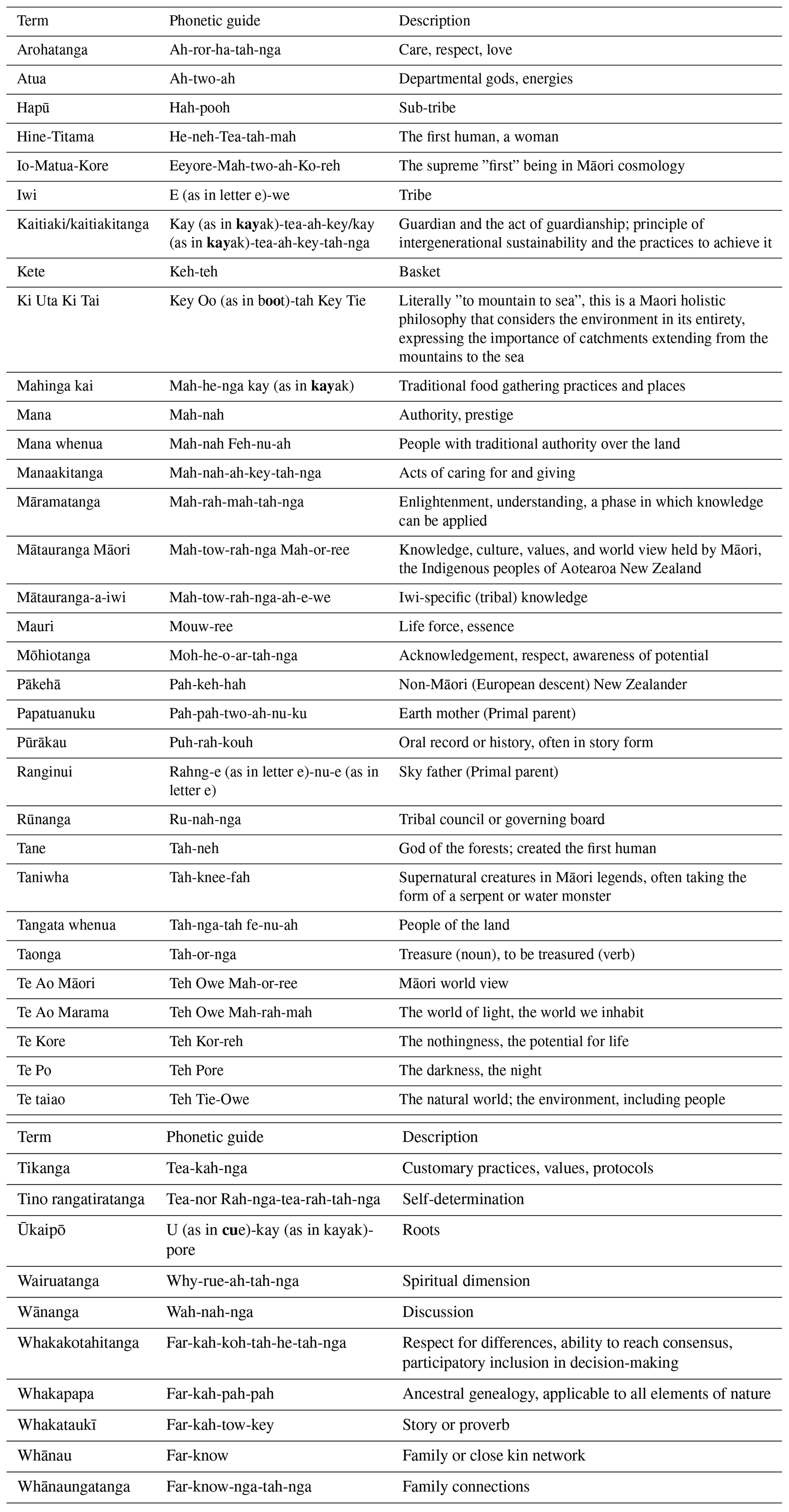
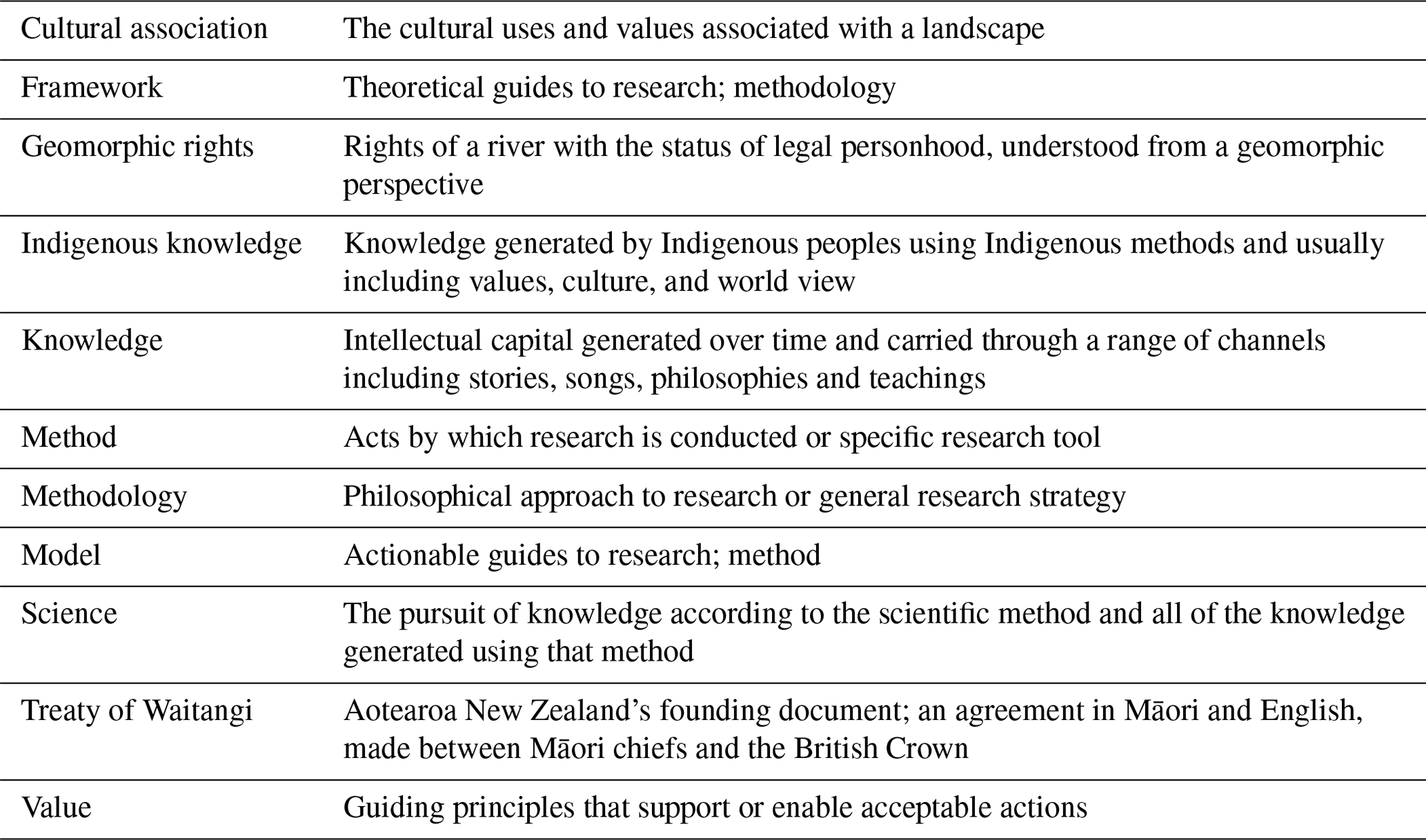
Te Ao Māori has, at its foundation, relationships between everything seen and unseen, human and more than human, the natural and beyond-natural world, and in turn shapes Māori ways of doing and living (Clapcott et al., 2018). After Māori settled in Aotearoa–NZ many centuries ago (Hikuroa, 2017), distinct groups emerged (today, about 40 iwi and hundreds of hapū) that built their identity from the surrounding mountains, lakes, and rivers (Ruru, 2018). These tribal identities have implications for mātauranga-a-iwi (iwi-specific mātauranga), tribal ancestry, credibility, and iwi-specific guardianship of tribal lands. Glossaries of Māori words (Table 1) and key English terminologies used in this paper (Table 2) are provided for reference.
3.1.1 Whakapapa and tikanga (validity through ancestry)
Whakapapa (ancestry) is the Māori way of understanding the world through genealogies (Forster, 2019). It links people to flora, fauna, mountains, rivers, oceans, and lakes through an understanding that all of nature descended from the atua (Māori gods) (Fig. 1; Harmsworth and Awatere, 2013). Whakapapa informs tikanga (cultural protocols and habits), which in turn informs how one should conduct their life (Graham, 2009).
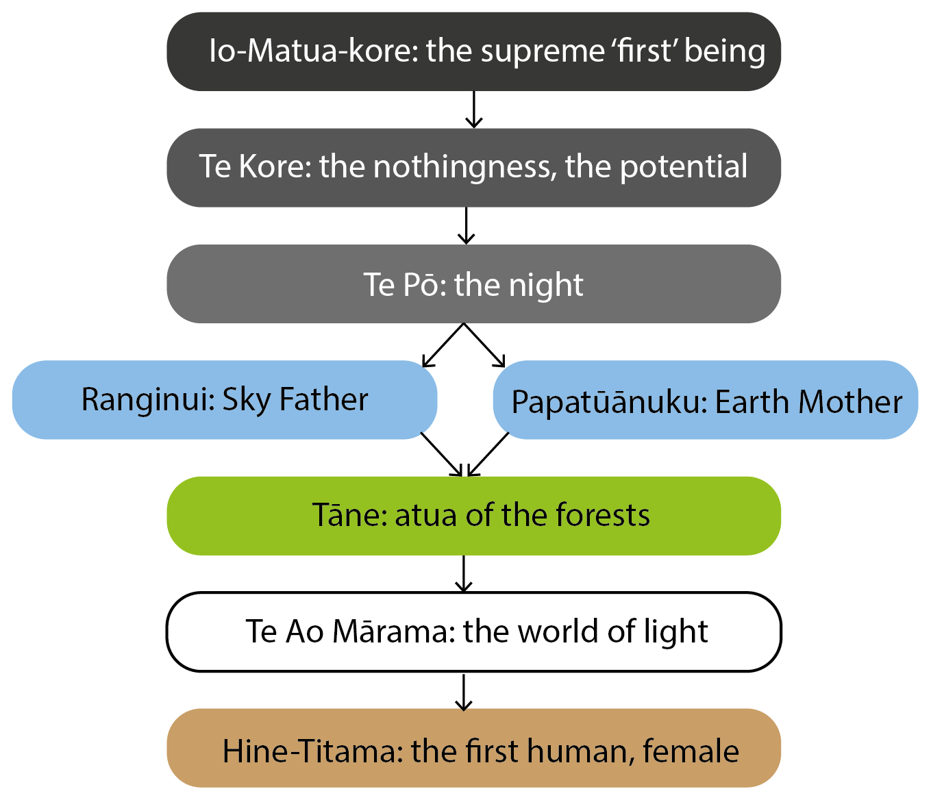
Figure 1The pedigree of mankind in Te Ao Māori. Modified from Graham (2009).
Whakapapa is at the core of Indigenous Māori knowledge generation (Graham, 2009). Whakapapa legitimates Māori epistemologies within research and fosters credibility by establishing connections between researchers and research objectives and by guiding research questions based on tikanga (Graham, 2009). By understanding that all things – both physical and metaphysical – are connected through genealogy (Hikuroa, 2017), it can be understood that whakapapa is a structured methodology for creating mātauranga (Royal, 1998). The relationships within whakapapa inform histories, stories, and interactions, which can be analysed in a Māori-centred way to create new knowledge (Fig. 2).

Figure 2Generation of Māori knowledge. Modified from Graham (2009).
3.1.2 Mātauranga Māori (Māori knowledge)
Mātauranga Māori is a detailed and dynamic way of knowing that has its ūkaipō (roots) in Māori ancestry (Paul-Burke et al., 2018). Mātauranga is a taonga (treasure) that is lived, practised, tested, and updated and that grows and develops as it is passed from generation to generation. Based on Polynesian origins (Clapcott et al., 2018), Māori have been developing their mātauranga since their arrival to Aotearoa–NZ some 800–1000 years ago (Broughton et al., 2015). Mātauranga is not only knowledge but also a method of expressing knowledge through language, cultural practices, values, principles, and ethics (Hikuroa, 2017; Paul-Burke et al., 2018). Mātauranga taiao (Māori environmental knowledge) is both traditional and contemporary and reflects the totality of Māori interactions with the environment during their occupation of Aotearoa–NZ (King et al., 2007).
Mātauranga-a-iwi provides local, place-based knowledge for an iwi's tribal area. This knowledge can provide intimate understandings of landscape dynamics and change through time. Mātauranga-a-iwi is informed directly by whakapapa (ancestry) because local landscape features are seen as kin through genealogical ties (Wilkinson and Macfarlane, 2020; Ruru, 2018). The aim is to live with the environment in an intergenerationally sustainable way in which the landscape and its resources are respected as elders. Interacting with specific landscape features has generated and developed mātauranga-a-iwi and continues to refine local Indigenous knowledge.
3.1.3 Kaitiakitanga (wellbeing of people and environment)
In Te Ao Māori, mana whenua (traditional authorities) are the kaitiaki (guardians) of their lands, waters, and physical and cultural environments. Kaitiakitanga (guardianship) is a responsibility to maintain the wellbeing of people and environment. Contemporary kaitiakitanga can be understood as implementation of mātauranga-informed decisions and management (Clapcott et al., 2018; Paul-Burke et al., 2018). It can also be understood as the responsibility to guide research priorities in the interest of the environment and the landscape. For example, studies that consider water quality and establish baseline minimums for flow (e.g. Tipa, 2009; Crow et al., 2018; Hikuroa et al., 2018) are expressions of kaitiakitanga in modern research and management.
3.2 Obligations of the Aotearoa New Zealand government to Māori through the Treaty of Waitangi
The founding document of the modern state of Aotearoa–NZ is the Treaty of Waitangi (Hudson and Russell, 2009). The Treaty represents the establishment of a formal relationship between the British Crown and Māori, in which Māori are legal partners of the Crown. Two versions of the Treaty exist: one in te reo Māori (Māori language) and one in English. The te reo Māori text was signed in Waitangi on 6 February 1840 by more than 40 Māori chiefs and was then circulated to other Māori communities around the country (Anderson et al., 2015). Not all chiefs signed the Treaty, but it did receive more than 500 Māori signatures. The Treaty established that Māori taonga (treasures), including mātauranga, would be protected and that Māori had the right to participate as active citizens of Aotearoa–NZ. To Māori, the status of the Treaty remains as strong and relevant today as it did in 1840; however, the applicability of the Treaty within modern Aotearoa–NZ has changed (Durie et al., 1989, as cited in Hudson and Russel, 2009).
In 1988, the Royal Commission on Social Policy made a gesture to establish interpretations of the Treaty that would be applicable in modern Aotearoa–NZ society (Durie, 1994; Hudson and Russel, 2009). These interpretations have been further refined (Waitangi Tribunal, 2016) and are known as the Principles of the Treaty. The Principles of the Treaty, developed by the Waitangi Tribunal, intend to ensure that interactions between Māori and Crown entities – including research interactions – are ethical and within the stipulations of the Treaty. Select resource-specific principles (Brierley et al., 2018) indicate that the right to establish the spiritual and cultural significance of certain landscape features and resources remains with mana whenua (traditional authorities) (Harmsworth et al., 2016).
3.2.1 The Treaty in practice
The Principles of the Treaty mandates that scientific investigations must consider the applicability and appropriateness of including Māori in research projects. Moreover, the Principles of the Treaty reflects the te reo Māori (Māori language) version of the Treaty, which refers to depths of knowledge and implicitly includes science within the construct of mātauranga. Several research projects conducted within Aotearoa–NZ over the past few years exemplify the Treaty in practice. Harmsworth et al. (2016) outline Aotearoa–NZ legislative frameworks that apply the Treaty of Waitangi to modern research endeavours. Here, we discuss two major advances in culturally responsive legislation.
Te Manahuna Aoraki Project
The Department of Conservation (DOC) is Aotearoa–NZ's government agency for conservation of national heritage, both natural and historic. DOC has a strict consultation procedure for engaging with iwi (tribes), hapū (sub-tribes), and whānau (family groups). The consultation process is meant to uphold DOC's status as a Treaty partner and employs the principles of partnership, protection, redress and reconciliation, and informed decision making (Department of Conservation, 2019).
A modern and ongoing example of the DOC consultation process with iwi is through Te Manahuna Aoraki Project. The players in this project are DOC, the NEXT foundation, Te Rūnanga o Waihao, Te Rūnanga o Moeraki, Te Rūnanga o Arowhenua, and others (Te Manahuna Aoraki Project, 2018). The iwi are official partners, which elevates their status from stakeholder to decision maker (Jo McLean, in Booth et al., 2019). The consultation process is not easy, however, as not all players will have the same priorities. For iwi, spiritual values of the Te Manahuna (the Mackenzie basin) are held as a priority to be conserved, which may be challenging to communicate to their partners (Jo McLean, in Booth et al., 2019). However, both Pākehā (European New Zealanders) and Māori parties recognise Te Manahuna as a place of vitality, which can enable mutual respect for partners and the landscape.
The consultation process is still in its early stages (Jo McLean, in Booth et al., 2019), but the purpose is to make a transformational shift in the way that organisations come together to deliver outcomes (Suzette van Aswegen, in Booth et al., 2019). Though this project is for conservation and management, there are many lessons that can be transferred to geomorphic research. Early consultation, legitimate partnership with iwi, sustained discussions, and fair consideration of all key players' views are essential for a successful project that involves Māori and non-Māori researchers.
Te Awa Tupua
In 2017, the Whanganui River on the North Island of Aotearoa–NZ gained the status of legal personhood. Te Awa Tupua was declared as “an indivisible and living whole from the mountains to the sea, incorporating the Whanganui River and all of its physical and metaphysical elements” (Te Awa Tupua, 2017). Granting a river system personhood rights reflects a Māori approach to river system interaction and understanding. After Te Awa Tupua was legally recognised, Brierley et al. (2018) defined the geomorphic implications of the act. The authors posited that the river now has the following geomorphic “rights” (Brierley et al., 2018, p. 4):
-
“A right to flowing water, and associated spatial and temporal variability in hydrologic and hydraulic regime.
-
A right to convey sediment, adjusting the balance of erosional and depositional processes in any given reach, and how these reaches fit together at the catchment scale, as materials are transported from “source to sink.”
-
A right to be diverse, reflecting geographic and historical controls upon the inherent geodiversity (i.e. heterogeneity and/or homogeneity) of a river reach.
-
A right to adjust, shaped by mutual interactions between flow, sediment, riparian vegetation, wood, ecosystem engineers, and groundwater that set the dynamic habitat mosaic of river systems.
-
A right to evolve, set by responses to disturbance events and changes to boundary conditions that influence the trajectory of geomorphic adjustment of a river.
-
A right to operate at the catchment scale, as connectivity relations determine how changes to one part of a river system impact elsewhere in the catchment, and at the coastal interface, over what timeframe.
-
A right to be healthy, operating as a living river that maintains its integrity, vigour, and vitality, maximising its resilience to impacts of disturbance.”
Brierley et al. (2018) state that the river has the right to be a river, the right to flow freely and transport sediment from the mountains to the sea. The river has a right to be a living system (Salmond et al., 2019). Brierley et al. (2018) argue that Te Awa Tupua was a milestone achievement in river management and geomorphologic research because river scientists created research questions that reflected both societal and environmental values. This act has implications for future legal interactions concerning mātauranga Māori, Māori world view, science, landscape research priorities, and conservation efforts (Ruru, 2018; Geddis and Ruru, 2019).
3.3 Woven spaces – the interface of mātauranga Māori and science
3.3.1 The relationship between mātauranga and science
Like with many Indigenous knowledge systems, mātauranga Māori has historically been “systematically dismissed and erased … as being worthless” (Waitangi Tribunal 1999, as cited in Broughton et al., 2015). However, when expressed in a way to which Western scientists can relate, it is clear that Māori generated some of their knowledge in ways consistent with the scientific method (Cunningham, 2000; Hikuroa, 2017). Over the past decade, select Māori researchers in the physical sciences (e.g. King et al., 2007; Tipa, 2009; Harmsworth et al., 2016; Hikuroa, 2017; Hikuroa et al., 2018; Paul-Burke et al., 2018) have made strides for advancing mātauranga alongside Western science. These researchers have promoted the mana (authority) of mātauranga and advocated for its place in national research through their own research endeavours. As a result of the efforts of these researchers, as well as others in different fields (e.g. Durie, 2004; Smith, 2012; Macfarlane et al., 2015), the Aotearoa–NZ government now requires an acknowledgement and consideration of research relevance to Māori in many major grant and funding applications, such as the Hīkina Whakatutuki Ministry of Business Innovation and Employment's Endeavour Fund, National Science Challenges, and Te Pūnaha Hihiko: Vision Mātauranga Capability Fund (Hīkina Whakatutuki Ministry of Business, Innovation and Employment, 2019). Notably, in 2011, the Vision Mātauranga policy statement was incorporated into the Statements of Core Purpose of Crown Research Institutes (CRIs), which requires CRIs to enable the potential for innovative research with Māori.
Perhaps the major difference between Indigenous knowledge (here, mātauranga) and science is perception of objectivity. In a scientific world view, objectivity is essential for making unbiased observations to test hypotheses (Moller, 2009; Crawford, 2009). Facts and values are separated (Hikuroa, 2017). In a Māori world view, humans sit within natural systems, along with all other components. There is no separation between values and facts. The reciprocity between values and facts may be considered another major difference between mātauranga generation and Western knowledge generation. However, because Māori values are both traditional and contemporary, Māori perspectives have the potential to contribute to innovative research approaches in which knowledge is co-created considering both Māori and Western values. Rather than contesting relative validities, Durie (2004) and Peet (2006) demonstrate that work at the interface can be a space for inventiveness and inspiration.
Indigenous values
Māori values can, in part, be understood as the means by which Māori make sense of and understand their environment (Marsden et al., 1988; Harmsworth and Awatere, 2013). Examples of these values include tikanga (cultural protocols), whakapapa (genealogy), tino rangatiratanga (self-determination), mana whenua (traditional authorities), whanaungatanga (family connections), kaitiakitanga (guardianship), manaakitanga (acts of care), whakakotahitanga (respect for differences), arohatanga (love, care), and wairuatanga (spirituality). Māori values directly inform mātauranga (knowledge), and mātauranga informs Māori values (Harmsworth and Awatere, 2013).
3.3.2 Identifying mutual research needs and benefits
In 2007, the Aotearoa–NZ government outlined a goal for research at the interface of Western science and mātauranga Māori in their Vision Mātauranga statement: “to unlock the innovation potential of Māori knowledge, resources and people to assist New Zealanders to create a better future” (Ministry of Research, Science and Technology, 2007). One of the four Vision Mātauranga research themes is Taiao: achieving environmental sustainability through Iwi and Hapū relationships with land and sea. This theme explores iwi (tribe) and hapū (sub-tribe) relationships with land- and seascapes and encourages Māori involvement in research relating to the sustainability of these environments. This official document is a tool for researchers considering different projects and their applicability to Māori. Though Vision Mātauranga does not explicitly outline how to conduct research at the interface (Macfarlane and Macfarlane, 2018), it establishes the context for bicultural approaches to research.
Iwi management plans (IMPs) and iwi environmental management plans (IEMPs) are official documents that can be used to define iwi-identified research needs. Extensive work has been completed to highlight the utility of IMPs as guides and frameworks for engagement with Māori (Saunders, 2017). IMPs provide clear, official documentation of iwi values and interests that can be considered in research (Waikato Regional Council, 2019). Many IMPs and IEMPs discuss iwi goals for minimum river flows and flood hazards (e.g. Tipa et al., 2014), which are specifically relevant to geomorphologists. Some plans have sections with specific goals for rivers (e.g. Waikato-Tainui Te Kauhanganui Incorporated, 2013) or catchments (e.g. Te Rūnanga o Kaikōura et al., 2005; Jolly and Ngā Papatipu Rūnanga Working Group, 2013). Most IMPs are focused on improving the mauri (life force, vitality) of landscapes.
IMPs provide the opportunity for mātauranga Māori to be included in planning and research projects as a knowledge system parallel to Western science (Saunders, 2017). In addition to outlining key values and interests, IMPs provide specific guidance to researchers and planners on how each iwi (tribe) proposes consultation and engagement activities might proceed.
3.3.3 Potential challenges and risks of conducting research at the cultural interface
It is essential to note that there may be circumstances when it is inappropriate to draw upon both Western science and mātauranga Māori (Mercier, 2007). Mika and Stewart (2017) in fact advocate that perhaps it is better to maintain a binary research sphere all together, wherein Western and Māori approaches are kept separate. There may be situations when one explanation (i.e. Indigenous) for an event does not align with another explanation (i.e. Western). For example, research concerning oral histories of meteor impact craters in Australia indicate that it is possible that events recorded in oral histories cannot be correlated with physical scientific evidence (e.g. Hamacher and Norris, 2010) or that some landscapes do not have associated oral histories (e.g. Hamacher and Goldsmith, 2013). In cases such as these, it is essential to maintain mutual respect by not using one method to prove the other method wrong (Durie, 2004). Accordingly, science and mātauranga should not be used to disprove each other (Hikuroa et al., 2011; Hikuroa, 2017). It becomes the researcher's responsibility to determine which approach provides the stronger supporting evidence but not by dismissing one knowledge base over the other due to inconsistencies or discrepancies. If done appropriately, it is possible for the two approaches to strengthen one another and provide better outcomes for all involved (Durie, 2007). These could be opportunities to explore the richness and contingency of oral traditions separate from scientifically determined landscape events. Equally, oral traditions could be the only record of something that was perishable in the geomorphological/geological record. In cases where scientific findings and Indigenous knowledge do align, the supporting evidence is purely stronger.
A Māori world view accepts that there can be more than one explanation for an event or landform. The concept of contested knowledge and opposing viewpoints between Indigenous communities was an accepted part of life (Smith, 1999). This led to creating an environment of tolerance, mutual respect, and reciprocity between Indigenous communities. Having multiple ideas or explanations for an event is also common in the field of geomorphology, where landscape formation can be explored through multiple working hypotheses via the principle of equifinality. While conducting research at the interface poses many challenges, it reveals similarities such as these and presents opportunities to generate corroborative evidence for events and landforms.
Extensive work has been done by Māori researchers to develop frameworks and models for including Māori knowledge, values and tikanga (cultural protocols) in research. Smith (1992) established and promoted ways for non-Māori researchers to engage with Māori and maintain a standard of cultural responsibility. Smith (2012) later described kaupapa Māori research, or research by Māori for Māori, and detailed appropriate ways for Māori to lead their own research aspirations. The methodologies proposed by Smith (1992, 2012) can be thought of as frameworks: guiding principles according to which researchers define research questions, select tools and approaches to address questions, and plan analyses (Harding, 1987; Smith, 2012).
Harmsworth et al. (2016) and Rainforth and Harmsworth (2019) discuss models for integrating Māori values into environmental research. The models can be thought of as methods: actions or procedures by which a researcher addresses core research questions and collects data (Smith, 2012). The models reviewed by Harmsworth et al. (2016) and Rainforth and Harmsworth (2019) are Indigenous approaches to research, which include Indigenous values and protocols (Smith, 2012). Indigenous approaches to research are commonly structured as models or decision support tools (Morgan, 2006) that empower Indigenous values alongside Western practices (Hikuroa et al., 2018). Harmsworth et al. (2016) and Rainforth and Harmsworth (2019) indicate that a strong effort to include mātauranga Māori has been made in ecological and environmental assessments but reveal a dearth of studies that weave mātauranga Māori with geomorphic research.
This section introduces three theoretical frameworks (i.e. methodologies) for including or considering mātauranga Māori in geomorphic research. The frameworks discussed here have been previously analysed in the health and education contexts (e.g. Macfarlane et al., 2015; Macfarlane and Macfarlane, 2018). We discuss how each theoretical framework could be transferrable to geomorphic research. Keeping in mind that mātauranga and values cannot always be separated, we then introduce three models (i.e. methods) for including Māori values within science conducted according to Western practices and highlight how each model could be used in geomorphic research. A critical assessment of the frameworks and models is provided in Sect. 5, and a discussion of how these frameworks and models can be applied outside of Aotearoa–NZ is provided in Sect. 6.
4.1 Theoretical frameworks for including mātauranga Māori in geomorphic research
The following theoretical frameworks are guiding methodologies for including mātauranga Māori in research projects. The three frameworks reviewed here have been discussed by Macfarlane and Macfarlane (2018), but here we also discuss their applicability to geomorphology. Although these frameworks were developed and promoted by researchers seeking better outcomes in the health and education sphere, we do not believe they are necessarily only applicable to those spaces.
4.2 He Poutama Whakamana (mirror images of knowledge and understanding)
The He Poutama Whakamana framework draws directly from principles that reflect the intent of the Ministry of Research, Science and Technology's (2007) Vision Mātauranga policy (Macfarlane and Macfarlane, 2018). He Poutama Whakamana alludes to mirror-imaged panels – Poutama Tukutuku – that are typically present in traditional Māori meeting houses (Fig. 3). These Poutama Tukutuku represent a journey of growth and learning in order to metaphorically climb up to where knowledge and understanding are achieved.
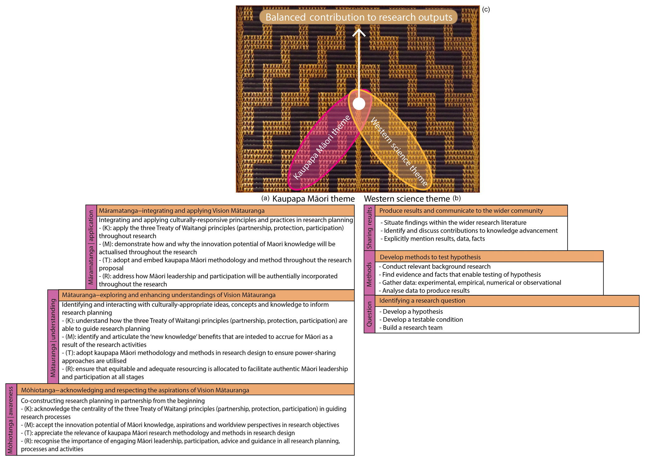
Figure 3(a) The He Poutama Whakamana framework (Macfarlane and Macfarlane, 2018) mirrored by (b) the scientific method theory on the opposite side of the Poutama Tukutuku. Panel (c) represents upwards growth towards co-creation of knowledge.
Macfarlane and Macfarlane (2018) propose that this is a good framework for including Māori phenomena (e.g. individuals, culturally significant landscapes, values) into research. There are three main steps of the framework: mōhiotanga (acknowledgement, respect), mātauranga (knowledge, understanding) and māramatanga (integration, application). Each of the three steps individually and uniquely addresses four principles from Vision Mātauranga: kaitiakitanga (guardianship), mātauranga (knowledge), tikanga (customary protocols), and rangatiratanga (self-determination). These four principles reappear in each of the three steps, with different implications in each iteration (Fig. 3a). He Poutama Whakamana follows a kaupapa Māori research approach. Kaupapa Māori, described in depth by Smith (2012), can be understood as research that is “culturally safe” and that takes place within a Māori world view (Irwin, 1994, as cited in Smith, 2012). There is space for non-Indigenous researchers within a kaupapa Māori approach (Bishop, 1994, as cited in Smith, 2012).
The mirror-imaged panel symbolism of Poutama Tukutuku presents a metaphorical space for the scientific method to operate alongside the kaupapa Māori theme (Fig. 3b). Both themes can maintain their individual integrity and are strengthened during each level of the framework by “check-ins” that ensure the Vision Mātauranga principles are being reflected in both themes. Adequately addressing Vision Mātauranga principles in both themes has the potential to ultimately produce co-created knowledge (Fig. 3c). This approach also has the potential to emphasise the differences between the two approaches (e.g. Mercier, 2007), which may in its own right lead to better understandings and outcomes. He Poutama Whakamana is suitable for geomorphic research because it is open-ended and not specialised for any one field of research. It welcomes research conducted under the guidance of the Treaty of Waitangi, and as long as each step of the framework is addressed, the research will potentially be culturally responsible and safe.
4.2.1 IBRLA (initiation, benefits, representation, legitimation, accountability)
The IBRLA framework is an open-ended research framework that aims to ensure that Māori thinking and voice are included in research involving Māori (Bishop, 1996; Macfarlane and Macfarlane, 2018). It features a series of accountability questions within each component of the framework (Table 3). These questions are meant to guide researchers and help ensure that Māori knowledge is being included throughout the research project. These questions, such as “How did Māori participate in the conceptualisation and initiation process?” or “How will Māori thinking and knowledge be represented at all research phases?” hold researchers responsible for ensuring that Māori involvement and contribution is not only included but also prioritised in the research. Principles of the Treaty of Waitangi – partnership, participation and protection – feature throughout the IBRLA framework. In this framework, the accountability questions help ensure that mātauranga Māori is respected and upheld throughout the research process.
Table 3The IBRLA framework. Adapted from Macfarlane and Macfarlane (2018).
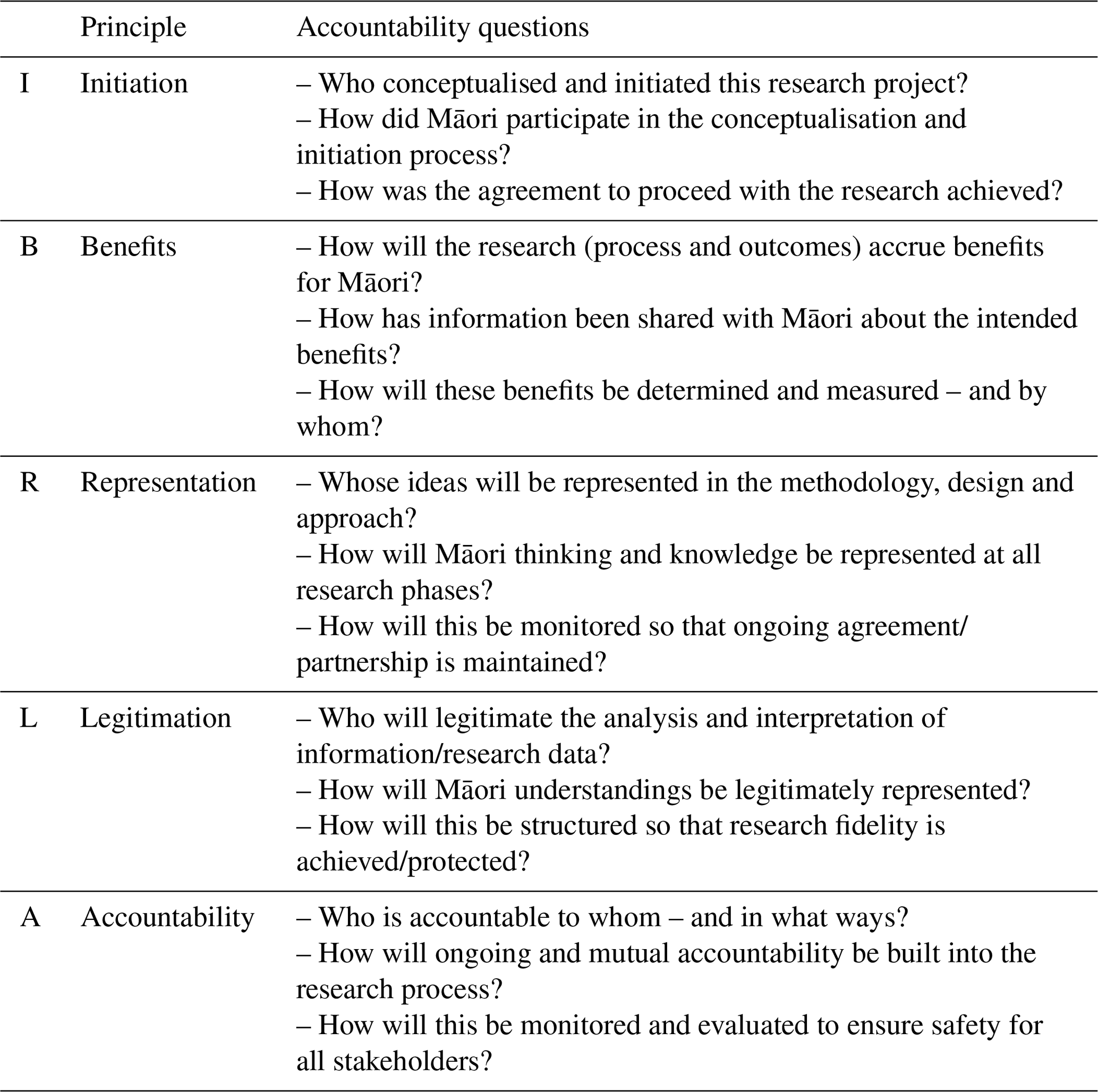
Just as the scientific method often encourages revisiting hypotheses, the IBRLA framework encourages researcher reflection during the concept design stage (similar to hypothesis formation and method development) through to the end of the research. The intent of IBRLA is to produce collaborative research stories (Bishop, 1996). This framework can provide a sense of researcher security when including Māori knowledge, while maintaining the integrity of the scientific method.
He Awa Whiria (a braided rivers approach)
The He Awa Whiria framework is based on the imagery of braided river systems (iconic landscape features throughout Aotearoa–NZ) and traditional woven baskets (Fig. 4). A research project designed under the He Awa Whiria framework has two streams, one representing Western science and the other representing Māori knowledge. Like a braided river, the streams may diverge, converge, and meander, but ultimately, they both flow in the same direction and towards the same goal. The streams are accompanied by the metaphor of knowledge kete (baskets), which is inspired by the Māori whakataukī (saying/proverb) “nā tō rourou, nā taku rourou, ka ora ai te iwi” (“with your food basket and my food basket, the people will thrive”). These symbols represent the weaving of Western science and Indigenous knowledge through a Māori world view, in which the integrity and sovereignty of each is respected.
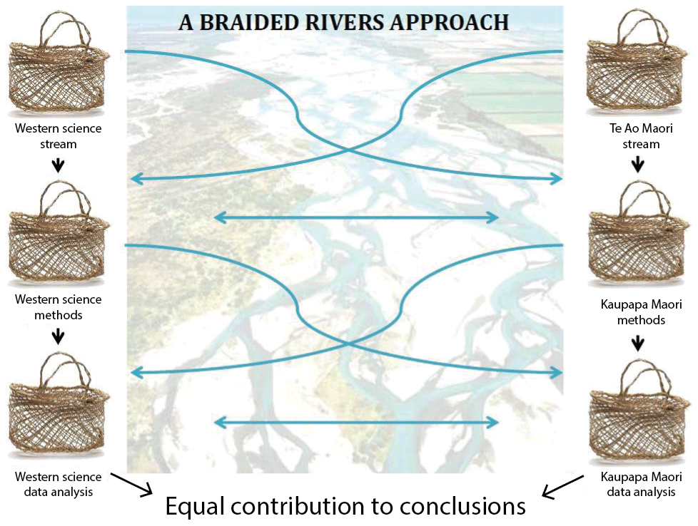
Figure 4The He Awa Whiria framework. The blue lines represent knowledge exchange and development as the two streams converge and re converge throughout the research programme. Modified from Macfarlane et al. (2015).
Throughout the duration of a research project, the streams may wane or grow in strength, change directions, or even die out in places, as do the channels in a braided river. Both streams have the same objective, which is to provide balanced contributions to research outcomes. It is accepted that the streams may spend more time apart than together (Macfarlane and Macfarlane, 2018). It is the researcher's role to manage how and when the two streams must converge and when it is appropriate for them to diverge. It is the also researcher's responsibility to make the moments of convergence times of learning. Ultimately, when research conclusions are drawn, they must represent co-creation of knowledge using both streams.
The He Awa Whiria methodology allows for flexibility within a research project. It recognises the benefits of both the Western science paradigm and kaupapa Māori principles and allows the research team to determine their own checks and balances. It provides grounds for mātauranga Māori input to guide and focus the Western science analysis. Wilkinson and Macfarlane (2020) demonstrate that the He Awa Whiria framework can be applied to geomorphic studies by allowing the two knowledge streams to operate both independently and collaboratively. The He Awa Whiria methodology supports a culturally responsible and responsive approach to research and allows for variable approaches to research depending on the specific topic (Macfarlane et al., 2015; Macfarlane and Macfarlane, 2018). Methodological adaptability is essential for conducting research with Māori, because different Māori groups will have different values, priorities, and interests when it comes to pursuing research questions.
4.3 Models for including Māori values in geomorphic research
The following models are step-by-step methods for explicitly including Māori values into scientific research. Many of these models were originally designed to assist with environmental decision-making and management. These models can be incorporated into the knowledge-inclusion frameworks above, creating research projects with nested frameworks (methodologies) and models (methods).
4.3.1 Mauri Model
The Mauri Model was developed as a tool for creating sustainable solutions for environmental decision-making in Aotearoa–NZ (Morgan, 2006; Faaui et al., 2017). It is grounded in the Māori concept of mauri, which can be best understood as an ethereal bond that links all elements of the natural world, the binding force between the physical and the metaphysical, the life-supporting capacity of soil and water. The Mauri Model is a decision-making model and provides a template for the explicit inclusion of Indigenous values with Western knowledge (Morgan, 2006). The aim of the Mauri Model is to define the degree of sustainability of proposed projects or activities by assessing the impact of an action on the mauri of an area (Hikuroa et al., 2011). The model considers a wide range of environmental, cultural, social, and economic indicators for use in analysis. Each indicator receives a value from a scale of −2 to +2, with −2 being mauri noho/mate (denigrated), −1 being mauri heke (diminishing), 0 being maintaining, 1 being mauri piki (enhancing), and 2 being mauri tu/ora (restored) (Fig. 5). The Mauri Model can work independently of science but is most effective when science is integrated into the analysis.
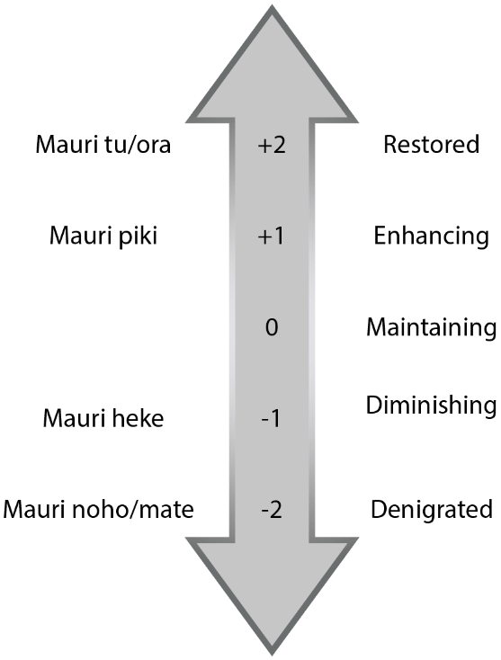
Figure 5“Mauri Meter” (Morgan, 2006); infographic of the valuing system in the Mauri Model. Modified from Hikuroa et al. (2011).
To complete the assessment, each indicator is listed in a table, and the integer values of each indicator are summed to determine the impact on the area of interest's mauri. This method could be appealing to researchers or project managers working in bicultural spaces because it combines stakeholder interests with Indigenous values in a semiquantitative model (Morgan and Fa'aui, 2018).
Morgan (2006) originally developed the Mauri Model to create a tool that could be utilised to include Māori input on water management issues in Aotearoa–NZ. It has since been used nationally and internationally to conduct environmental assessments in post-disaster maritime settings (Faaui et al., 2017), in geothermal development areas (Hikuroa et al., 2010), in areas of high anthropogenic modification (Hikuroa et al., 2018), and in dam impact studies (Morgan et al., 2012). Hikuroa et al. (2018) provide an extensive list of studies that have utilised the Mauri Model both within and beyond Aotearoa–NZ.
Transferability to geomorphology (Mauri Model)
Although the Mauri Model was designed as an assessment for the impact of human activities on an area, the ideas of denigrated and diminishing or enhanced and restoring landscapes can be transferred to geomorphology research. For example, in 2016 an Mw=7.8 earthquake struck the Kaikōura region on the South Island of Aotearoa–NZ (Hamling et al., 2017). The earthquake caused over 20 000 landslides that delivered mass amounts of sediment to river catchments (Massey et al., 2018). Fine sediment has been carried to the sea and has smothered and suffocated tidal to intertidal shallow-marine ecosystems (Schiel et al., 2019). High sedimentation coupled with coastal uplift has caused the biogeomorphology of the region to change dramatically following the earthquake (Schiel et al., 2019). The ongoing stability of marine species has the potential to indicate sedimentation rates and the effect that the geomorphology of the area has on marine populations. In a study of Te Awa o te Atua (Tarawera River), Hikuroa et al. (2018) showed that sedimentation is a contributing factor in the Mauri Model assessment. Therefore, we hypothesise that the Mauri Model could be applied to research investigating the effects of a natural geologic or geomorphic event (rather than a specifically human-induced act) on an ecosystem or landscape.
4.3.2 Cultural Flow Preference Study
The Cultural Flow Preference Study (CFPS) model was developed as a tool for Māori to assess their ability to engage in cultural practices within catchments at certain river flow levels (Tipa and Nelson, 2012) and to engage with freshwater resource management decisions (Crow et al., 2018). The CFPS model falls under the process of Cultural Opportunity Mapping, Assessments and Responses (COMAR), which are integrated processes that empower mana whenua (traditional authorities) to engage in freshwater studies and management (Tipa and Nelson, 2008).
As the CFPS is heavily site specific, it demonstrates the benefits that iwi (tribe) and hapū (sub-tribe) knowledge and values can bring to modern river management and scientific endeavours (Tipa, 2009; Crow et al., 2018). The CFPS model accounts for variations in cultural values between whānau (family groupings), hapū, and iwi by providing a method that can be transferred and applied for different studies. The first step of a CFPS is to identify the tangata whenua team (Māori or Indigenous participants), who act as the leading experts for a specific river or area, and determine the cultural values held by that team. After the tangata whenua team has been formed, a series of steps are followed in order to create a CFPS (Fig. 6). The ultimate aim of a CFPS is to link cultural values to variations in river flow and to determine how cultural values change depending on the flow of the river.
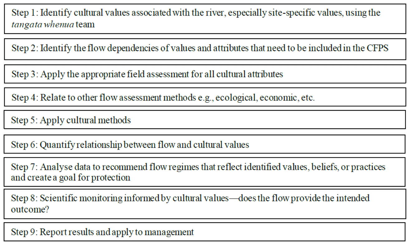
Figure 6Steps to complete a CFPS. Modified from Crow et al. (2018).
Transferability to geomorphology (CFPS)
CFPSs are applicable to geomorphic studies, specifically fluvial geomorphology. Tipa and Nelson (2012) demonstrate the utility of applying a CFPS in a study concerning the Kakaunui catchment, South Island, Aotearoa–NZ. During this process, they followed the CFPS method to (1) identify their tangata whenua team (Te Rūnanga o Moeraki); (2) have the tangata whenua team define their cultural association with the river; (3) conduct a participatory mapping exercise to identify how the local iwi (tribe) valued the river, what hydrological characteristics the local iwi believed to be essential to protect those values, how current and historic hydrologic and geomorphic characteristics differ, and how the current flow rates affect cultural values and uses; (4) identify and analyse tangata whenua-identified flow issues; and (5) calculate minimum flows that would satisfy cultural flow preferences. Through this method, Tipa and Nelson (2012) concluded that the current minimum flow in the Kakaunui Catchment (250 L s−1) is likely too low to maintain Te Rūnanga o Moeraki's values within the catchment. This study allowed geomorphic, hydraulic, ecologic, and cultural values to be considered in tandem. Identified tangata whenua values helped drive the research intentions and resulted in an outcome that could have application in future management of the Kakaunui catchment.
4.3.3 Sustainability Assessment Method
The Sustainability Assessment Method (SAM) is another environmental monitoring tool for assessing freshwater catchment health that can be used to include Māori values alongside more traditional monitoring assessments (Tipa, 2009). The SAM explicitly includes social, cultural, economic, and environmental values. This multidimensional assessment is laid-out in a step-by-step guide that enables researchers to document cultural values and associations with river catchments alongside scientific monitoring techniques (Fig. 7). The cultural dimension of this model focuses strongly on water quality and typically uses mahinga kai (traditional food gathering practices and places) as the most important indicator of the health of waterways.
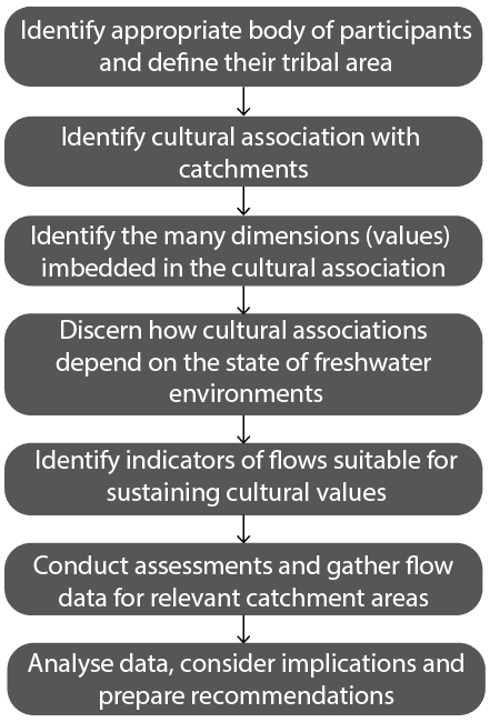
Figure 7Steps in the SAM. Modified from Tipa (2009).
The SAM follows a similar trajectory as other research frameworks involving Māori. The first step is to identify the appropriate group of tangata whenua participants, document their cultural relationships with a catchment, and ultimately determine baseline water quality and quantity standards compliant with Māori preferences. Tipa (2009) suggests that this model can be used as an alternative to strictly Western-style freshwater assessments, but it is possible that this model could be included alongside a Western-style analysis to build a more comprehensive assessment. Māori involvement is required, and the final step – analyse data, evaluate implications, and prepare strategies and recommendations – should include both Māori and Western interpretations of the results.
Transferability to geomorphology (SAM)
In 2005, the SAM was adapted for use in an assessment of New Zealand river catchments from Māori perspectives (Tipa, 2007, as cited in Tipa, 2009). Lists of Māori values, beliefs and practices associated with three river catchments in the South Island of Aotearoa–NZ were accumulated from analyses of contemporary writings and historical accounts. From the lists, tables were constructed to describe all concepts that portrayed a value, belief, or practice that surfaced from the initial analyses. Using the SAM allowed Māori concepts to be organised in a way that each element could be examined separately, in the context of each individual river. Beauty, mahinga kai, water quality and Ki Uta Ki Tai (from the mountains to the sea) are a few examples of the many identified by tangata whenua as important values within these catchments (Tipa, 2009). The result of this exercise was to show that the SAM could give resource managers the opportunity to consider cultural values alongside westernised resource management priorities. The SAM promotes a tool for policy makers that incorporates a place-based approach, allowing for more specialised outcomes.
As indicated by Tipa (2009), it would be possible to also include geomorphic values alongside a SAM analysis. Recalling Brierly et al.'s (2018) geomorphic rights of the river, the SAM would enable river geomorphologists and managers to apply equitable consideration to both Indigenous and scientific values in river management strategies or research projects. The requirement would be that the team includes members who are experts – either individually or collectively – in both mātauranga and scientific techniques. That way, geomorphic values can be considered alongside the cultural values proposed by the tangata whenua team. This sort of approach could yield better river management outcomes for both Māori and non-Māori.
The frameworks and models reviewed here do, ideally, require Māori guidance and Māori participation on the research team. In many cases, it may be appropriate to select a theoretical framework to guide research methodologies and, if appropriate, apply a value-based model within the research framework to act as a guide for the project's methods. This section provides an analysis of the presented theoretical knowledge frameworks and the value-based models, offers recommendations for geomorphic subdisciplines, and provides information about how researchers can identify research questions using Māori priorities.
5.1 Framework recommendations for subdisciplines
The theoretical research frameworks (e.g. He Poutama Whakamana, IBRLA, He Awa Whiria) are methodologies for weaving Māori world view and knowledge into or alongside many research disciplines, including geomorphology. These frameworks support and promote Māori knowledge and ensure that mātauranga is prioritised throughout the research process. They do not preclude researchers from using the scientific method to produce knowledge, but they do require that researchers also use a kaupapa Māori approach to co-create knowledge with Māori.
It may be best to select theoretical frameworks based on the distribution of Māori to non-Māori researchers involved in the research project. The He Poutama Whakamana and IBRLA models may be most appropriate for research teams where the research team has a majority of non-Māori leadership, because they are not strictly expressed through a Māori world view. These frameworks are rooted in Aotearoa–NZ governmental policy – the Treaty of Waitangi and Vision Mātauranga – and provide explicit checks and balances for researchers. Researcher reflection is a major element of these frameworks. The He Awa Whiria framework may be suitable for research teams comprising any ratio of Māori to non-Māori leaders. Because the two research streams converge, diverge, and act dynamically for the entirety of the project (Macfarlane et al., 2015), it may be possible for one stream to have a larger sub-leadership team than the other. This framework specifically allows for mātauranga Māori to focus the Western science stream. This balance will vary from project to project, but a project will successfully adhere to this framework as long as the interactions that do occur between the two streams foster learning and new knowledge generation (Macfarlane and Macfarlane, 2018).
So, which framework might a glaciologist, or a fluvial geomorphologist, or a pedologist, choose to ensure that they include Māori knowledge in their research? Selecting the right framework will stem from conversations with the appropriate iwi groups or Māori researchers early in the research process, and it will depend on the expertise of the research team. There is a common theme throughout frameworks and models that the first step is to identify the appropriate group of Māori participants, or tangata whenua, to act as the leading experts for their tribal areas. Once these individuals are identified, framework selection can happen cooperatively between scientists and tangata whenua. Each of the frameworks discussed here allow flexibility within the project and allow kaupapa Māori principles to excel alongside the scientific method. We therefore propose that framework selection must be done on a case-by-case basis, and the correct framework for any given research endeavour will be the one that suits all parties.
5.2 Model application to include Indigenous values
Explicitly including Māori values in research can be achieved by nesting value-based models (e.g. Mauri Model, CFPS, SAM) within the aforementioned theoretical frameworks. When value-based models are nested in Māori-focused theoretical frameworks, the interconnectedness between values and knowledge becomes apparent.
The models are useful tools to assist non-Māori researchers in including Māori knowledge by way of Māori values. Value-based models are an adequate way to follow step-by-step processes (similar to research processes produced according to the scientific method) that address Māori ways of knowing and living. The Mauri Model, CFPS, and SAM allow for explicit inclusion of iwi-identified cultural, environmental, and research values in geomorphic investigations. Model selection, like framework selection, will depend on the research questions at hand and must be done on a case-by-case basis as a joint decision between the Māori community from whom the mātauranga is sourced. Regardless of how Māori knowledge is included, it is ideal to have a Māori researcher on the project leadership team to minimise risk of cultural misrepresentation or appropriation of knowledge.
5.3 Guiding resources for initiating projects in Aotearoa–NZ
As previously discussed, many iwi (tribes) and hapū (sub-tribes) in Aotearoa–NZ have published iwi management plans or iwi environmental management plans that can outline research priorities for scientists (Saunders, 2017). Many IMPs contain information specifically relevant to geomorphologists. For example, most IMPs discuss iwi goals for minimum river flows and mitigating flood hazards (e.g. Tipa et al., 2014). Other iwi environmental management plans have sections with specific goals for rivers (e.g. Waikato-Tainui Te Kauhanganui Incorporated, 2013) or catchments (e.g. Te Rūnanga o Kaikōura et al., 2005; Jolly and Ngā Papatipu Rūnanga Working Group, 2013). Most IMPs focus on improving the mauri (life force, vitality) of landscapes over which the authoring organisation (typically a rūnanga, tribal council) possesses kaitiakitanga (guardianship). Researchers can use information outlined in IMPs and IEMPs to identify the appropriate research leadership team and select the appropriate research framework.
Research funding guidelines for projects that aim to include mātauranga Māori alongside Western science can be found through Aotearoa–NZ's Ministry of Research, Science and Technology. Specifically, the Ministry of Business, Innovation and Education (MBIE) operates Te Pūnaha Hihiko, the Vision Mātauranga Capability Fund, which provides guidelines for research projects in its application process (Ministry of Research, Science and Technology, 2007). The Marsden Fund, through the Royal Society of New Zealand, also provides for how proposals should include consideration of Māori involvement in research (Royal Society Te Apārangi, 2019).
Many universities and research organisations have iwi engagement and support teams. These teams are excellent resources for gaining guidance on identifying the best tangata whenua team for research needs and how to appropriately engage with iwi or hapū. In Aotearoa–NZ, the universities and CRIs, in particular, have excellent resources for connecting researchers with Māori. We recommend early and, ideally, regular interaction with these resource groups. It is worth noting that an argument exists to make Māori representation on research project teams mandatory, but ultimately, forcing Māori involvement runs the risk of perpetuating colonising practices. Instead, we maintain that the Māori community should decide how much – or how little – they wish to contribute to research projects. Engagement and support teams will be able to advise on this subject.
Indigenous knowledge around the globe is a valid source of information because it has endured for generations, keeping populations alive and securing their livelihoods. Moreover, Indigenous knowledge has been shown to be accurate and precise (Hikuroa, 2017). In this section, we outline some direct benefits of including Indigenous knowledge in geomorphic research, discuss how the frameworks detailed in this review can be adapted for use outside of Aotearoa–NZ, and discuss how Indigenous knowledge and geomorphic research can and are working together to inform sustainability policy and legislation.
6.1 Direct benefits to geomorphology
A clear benefit to geomorphology is the temporal extension of observations of geomorphic events into prehistory. The 400-year volcanic record discussed by Swanson (2008) and the cycles of flood and channel avulsion evaluated by Hikuroa (2017) indicate that Indigenous knowledge can bolster scientifically investigated geomorphic histories. King and Goff (2006) further demonstrated that Māori oral histories frequently discuss multiple geomorphic phenomena happening in tandem or as cascading events. Recognition of the interconnectedness of landscape processes is a common theme in many Indigenous societies (Riggs, 2005), and this recognition has resulted in a way of life that responds to, interacts with and learns from concurrent or cascading suites of local landscape processes.
Another key benefit of including Indigenous knowledge in geomorphic endeavours is the opportunity to co-create new approaches to research that build holistic and more complete understandings of landscape processes. Contemporary Indigenous knowledge and narratives can provide signposts for initiating and conducting geomorphic research by indicating geographic areas or research questions that are of interest to Indigenous groups. The concept of “ethnogeomorphology” (Wilcock and Brierley, 2012; Wilcock et al., 2013) draws upon modern Indigenous knowledge and relationships with landscapes to guide geomorphic research questions and methodologies. The dynamic and adaptive nature of Indigenous knowledge generation (Berkes, 2009) has the potential to influence adaptive research methods, which in turn have the potential to generate robust data collection with information from a variety of sources.
A prime example of how adaptive research methods incorporating Indigenous knowledge can provide significant contributions to geomorphic research is the New Zealand Palaeotsunami Database. The database aims to catalogue all tsunamis that occurred prior to written historical records and uses three types of evidence to identify palaeotsunami events: sedimentary/artefactual (“primary”), geomorphic (“secondary”), and anthropological/pūrākau (“cultural”) (Goff, 2008; NIWA, 2017). The cultural information allowed the database compilers to better constrain the age of palaeotsunami events by dating archaeological sites that were associated with the cultural information (Goff, 2008). A typical prehistoric Māori response to big waves was to abandon coastal settlements and move to higher elevations (Goff and Chagué-Goff, 2015). Cultural knowledge of the locations of abandoned sites allowed researchers to conduct archaeological investigations and date the time at which such sites had been occupied, thus providing a well-constrained date for the tsunami event. Māori pūrākau (oral histories/stories) often provide even more detailed information (McFadgen and Goff, 2007). Stories of taniwha (supernatural creatures in Māori mythology) may indicate big wave events that wreaked havoc on coastal communities, causing changes in settlement and local geomorphology (King and Goff, 2010; Goff and Chagué-Goff, 2015). Currently, cultural information is included for 14 % of recorded tsunami events in the database, most of which have come from pūrākau (NIWA, 2017). The cultural information, alongside geomorphic and sedimentary information, provides key data for the generation of a robust and comprehensive palaeotsunami database for Aotearoa New Zealand (Goff et al., 2010).
6.2 International application of Aotearoa–NZ bicultural research frameworks and models
Indigenous communities around the world share many fundamental principles, including their interconnectedness with and inseparability from nature (Salmón, 2000; Wambrauw and Morgan, 2016). Cultural values, such as environmental stewardship and sustainability, are also common Indigenous values that guide ways of living and ways of knowing. Common values among Indigenous cultures enable and encourage transferability of established frameworks outside of the place where they have been developed. The three theoretical frameworks discussed in this review – He Poutama Whakamana, IBRLA ,and He Awa Whiria – can potentially be applied outside of Aotearoa–NZ due to their flexible nature and adaptability for different research groups and purposes. Likewise, the value-based models – the Mauri Model, the CFPS and SAM – can be modified to incorporate Indigenous values and priorities outside of the Aotearoa–NZ context, because the models are specified with Indigenous groups on a case-by-case basis. Indigenous groups anywhere can identify which values they consider essential for the frameworks and models.
The Mauri Model, developed in Aotearoa–NZ, has been successfully applied in Papua, Indonesia, to evaluate the potential effects of a new agricultural development scheme in the Merauke regency in the lowlands of Papua (Wambrauw and Morgan, 2014, 2016). Due to its ability to incorporate Indigenous and Western values, the Mauri Model was deemed an appropriate tool to assess the potential environmental and cultural impacts of the development scheme. The first step to successfully applying the model was to understand the new context in which it would be used. After confirming the Mauri Model would be appropriate, stakeholders for the project were selected, which included the Malind Anim Indigenous peoples. The Mauri Model was adjusted to have a minimum value of −3 and a maximum value of +3 (rather than −2 and +2, respectively), based on local values and requirements. The results from using the Mauri Model indicated that the cultural values associated with the site would be denigrated if the development scheme proceeded. The Mauri Model provided semiquantitative evidence that the development scheme would have serious negative impacts on the Malind Anim.
It is challenging to review the applicability of Aotearoa–NZ frameworks and models to international geomorphic research because, to our knowledge, there are extremely few studies that explicitly use the tools to conduct geomorphic research outside of Aotearoa–NZ. However, we believe that there is great potential for these frameworks and models to be adapted outside of Aotearoa–NZ or for these tools to act as inspiration for the generation of new frameworks and models for use with Indigenous groups in other parts of the world. The case of using the Mauri Model in Papua indicates that this model is transferrable, which suggests that the others could be as well. If the models are adapted appropriately and in accordance with local Indigenous communities' values and desires, we see no encumbrance to using these models in international geomorphic research.
6.3 Benefits of Indigenous knowledge and geomorphology to society
There is a growing understanding that long-term sustainability on Earth is not achievable with monodisciplinary or reductionist scientific approaches (Pingram et al., 2019). Increasingly, geomorphology and Earth surface science are playing stronger roles in modern society and policy, guiding legislative action towards a more sustainable future. Sustainability is also at the core of many Indigenous cultures, which has enabled Indigenous knowledge and ways of life to persist for generations. We propose that both Indigenous concepts and values and westernised understandings of landscape processes have the potential to generate significant changes in the way people interact with the Earth's surface. More so, if these two streams of knowledge work together from the onset of a research project, there is the possibility of making discoveries that could not be made by either approach alone.
Landmark policy achievements that consider both scientific and Indigenous concepts emphasise the human and non-human elements of landscapes (Brierley et al., 2018; Aho, 2019; Pingram et al., 2019). These policies prioritise sustainability by acknowledging the integrity of both geomorphic science and Indigenous knowledge. These policies include legal personhood for rivers and the legal rights of nature (Brierley et al., 2018; O'Donnell and Talbot-Jones, 2018; Eckstein et al., 2019). Policies such as these provide opportunities for geomorphologists and Indigenous communities to act as advocates for the landscape, which is a relatively novel approach to sustainable landscape management and interaction within westernised societies.
Incorporating Indigenous knowledge with Western science has the potential to bring mutual benefits to scientists, Indigenous communities, and governments. This review highlighted theoretical frameworks for including mātauranga Māori and Māori value-based models into geomorphic research in Aotearoa–NZ. Each of the theoretical frameworks (He Poutama Whakamana, IBRLA, and He Awa Whiria) and value-based models (the Mauri Model, Cultural Flow Preference Study, and the Sustainability Assessment Method) provide different benefits to scientists and Māori. The most appropriate framework selection for projects will occur on a case-by-case basis with Māori involvement. Though this review mostly focused on the Aotearoa–NZ context, these frameworks are all capable of being applied in bicultural research contexts across the globe, so long as they accurately reflect the values and knowledge of the local Indigenous peoples. We encourage geomorphologists interested in working with Indigenous communities to consult with Indigenous peoples engagement support teams or Indigenous studies departments at their local research institutes. Additionally, in Aotearoa–NZ, we encourage researchers embarking on geomorphic research to consult iwi management plans and national funding guidelines for assistance in identifying potential research avenues that may include mātauranga. The potential for including these tools in geomorphic research is promising, particularly where such work overlaps with iwi aspirations.
We hope this review encourages and inspires geomorphologists to explore landscapes in Aotearoa–NZ and the world through a bicultural lens, one that includes both Indigenous knowledge and modern scientific techniques to acknowledge and respect the uniqueness of the world's landscapes. Using the approaches reviewed here has a high potential to yield better outcomes, as drawing from both knowledge systems will realise new understandings and solutions that neither body of knowledge could reach in isolation.
This research reflects the synthesis, analysis, and review of existing publications, reports, and government documents. No data sets were used in this article.
CW and DCHH developed the original ideas and organisation of this review. AHM provided translations for Māori terminology and developed ideas for theoretical framework analysis. MWH contributed concepts that also improved framework and model analysis. CW prepared the review with contributions from all coauthors.
The authors declare that they have no conflict of interest.
The authors kindly thank Timothy Stahl for his comments and feedback that greatly improved previous versions of this article. We thank Carolina Londono and an anonymous reviewer for their constructive feedback that further strengthened this article and Heather Viles for managing our article. This project was (partially) supported by QuakeCoRE, a New Zealand Tertiary Education Commission-funded Centre. This is QuakeCoRE publication number 0586.
This research has been supported by the University of Canterbury School of Earth and Environment and by QuakeCoRE (grant no. 328MHQGRNT).
This paper was edited by Heather Viles and reviewed by Carolina Londono and one anonymous referee.
Aho, L. T.: Te Mana o te Wai: An indigenous perspective on rivers and river management, River Res. Appl., 35, 1615–1621, https://doi.org/10.1002/rra.3365, 2019.
Alessa, L., Andrade, C., Cash, P. C., Giardina, C. P., Hamabata, M., Hammer, C., Henifin, K., Joachim, L., Johnson, J. T., Kealiikanakaoleohaililani, K., Kingston, D., Kliskey, A., Louis, R. P., Lynch, A., McKenny, D., Marshall, C., Roberts, M., Tangaro, T., Wheaton-Abraham, J., and Wingert, E.: Indigenous knowledges driving technological innovation (The Hi'iaka Working Group), AAPI Nexus, 9, 241–248, 2011.
Anderson, A., Binney, J., and Harris, A.: Tangata Whenua A History, Bridget Williams Books Ltd, Wellington, NZ, 418 pp., 2015.
Atik, M. and Swaffield, S.: Place names and landscape character: a case study from Otago Region, New Zealand, Landscape Res., 42, 455–470, https://doi.org/10.1080/01426397.2017.1283395, 2017.
Barrera-Bassols, N.: Linking Ethnopedology and Geopedology: A Synergistic Approach to Soil Mapping. Case Study in an Indigenous Community of Central Mexico, in: An Integration of Geomorphology and Pedology for Soil and 720 Landscape Studies, Geopedology, edited by: Zinck, J. A., Metternicht, G., Bocco, G., and Valle, H. F. D., Springer, Switzerland, 2015.
Becker, J., Johnston, D., Lazrus, H., Crawford, G., and Nelson, D.: Use of traditional knowledge in emergency management for tsunami hazard: A case study from Washington State, USA, Disast. Prevent. Manage., 17, 488–502, https://doi.org/10.1108/09653560810901737, 2008.
Berkes, F.: Indigenous ways of knowing and the study of environmental change, J. Roy. Soc. N. Zeal., 39, 151–156, https://doi.org/10.1080/03014220909510568, 2009.
Bishop, R.:Initiating Empowering Research?, N. Zeal. J. Educ. Stud., 29, 175–188, 1994.
Bishop, R.: Collaborative Research Stories Whakawhanaungatanga, The Dunmore Press, Palmerston North, New Zealand, 273 pp., 1996.
Bohensky, E. and Maru, Y.: Indigenous Knowledge, Science, and Resilience: What Have We Learned from a Decade of International Literature on “Integration”?, Ecol. Soc., 16, 6, https://doi.org/10.5751/ES-04342-160406, 2011.
Booth, K., McLean, J., and van Aswegan, S.: Protecting the natural and cultural landscapes of the Mackenzie Basin: A new approach, available at: https://vimeo.com/355293339, last access: 22 October 2019.
Boyd, D.: The rights of nature: a legal revolutoin that could save the world, ECW Press, Toronto, 2017.
Brierley, G., Tadaki, M., Hikuroa, D., Blue, B., Šunde, C., Tunnicliffe, J., and Salmond, A.: A geomorphic perspective on the rights of the river in Aotearoa New Zealand, River Res. Appl., 35, 1640–1651, https://doi.org/10.1002/rra.3343, 2018.
Broughton, D., McBreen, K., and Waitaha, N. T.: Mātauranga Māori, tino rangatiratanga and the future of New Zealand science, J. Roy. Soc. N. Zeal., 45, 83–88, https://doi.org/10.1080/03036758.2015.1011171, 2015.
Cano Pecharroman, L.: Rights of Nature: Rivers That Can Stand in Court, Resources, 7, 13, https://doi.org/10.3390/resources7010013, 2018.
Carter, L.: Naming to Own Place Names as Indicators of Human Interaction with the Environment, AlterNative: Int. J. Indigen. Peopl., 1, 6–24, https://doi.org/10.1177/117718010500100102, 2005.
Clapcott, J., Ataria, J., Hepburn, C., Hikuroa, D., Jackson, A.-M., Kirikiri, R., and Williams, E.: Mātauranga Māori: shaping marine and freshwater futures, N. Zeal. J. Mar. Freshwater Res., 52, 457–466, https://doi.org/10.1080/00288330.2018.1539404, 2018.
Crawford, S.: Matauranga Maori and western science: The importance of hypotheses, predictions and protocols, J. Roy. Soc. N. Zeal., 39, 163–166, https://doi.org/10.1080/03014220909510571, 2009.
Cronin, S. J., Gaylord, D. R., Charley, D., Alloway, B. V., Wallez, S., and Esau, J. W.: Participatory methods of incorporating scientific with traditional knowledge for volcanic hazard management on Ambae Island, Vanuatu, Bull. Volcanol., 66, 652–668, https://doi.org/10.1007/s00445-004-0347-9, 2004.
Crow, S. K., Tipa, G. T., Booker, D. J., and Nelson, K. D.: Relationships between Maori values and streamflow: tools for incorporating cultural values into freshwater management decisions, N. Zeal. J. Mar. Freshwater Res., 52, 626–642, https://doi.org/10.1080/00288330.2018.1499538, 2018.
Cruikshank, J.: Glaciers and Climate Change: Perspectives from Oral Tradition, Arctic, 54, 377–393, 2001.
Cruikshank, J.: Are Glaciers `Good to Think With'? Recognising Indigenous Environmental Knowledge, Anthropol. Forum, 22, 239–250, https://doi.org/10.1080/00664677.2012.707972, 2012.
Cunningham, C.: A framework for addressing Māori knowledge in research, science and technology, Pacif. Health Dial., 7, 62–69, 2000.
Department of Conservation: Iwi/hapū/whānau consultation, available at: https://www.doc.govt.nz/get-involved/apply-forpermits/iwi-consultation, last access: 22 October 2019.
Durie, E. T. J., Temm, P. B., Wilson, W. M., and Kenderdine, S.: New Zealand Law Society seminar: the Treaty of Waitangi, The Society, Wellington, New Zealand, 1989.
Durie, M.: Whaiora, Mäori health development, Oxford University Press, Auckland, 67–81, 1994.
Durie, M.: Exploring the interface between science and indigenous knowledge, in: Capturing Value from Science, Christchurch, NZ, available at: https://www.researchgate.net/profile/Mason_Durie/publication/253919807_Exploring_the_Interface_Between_Science_and_Indigenous_Knowledge/links/573d839108aea45ee842959f.pdf (last access: 19 July 2019), 2004.
Durie, M.: Alignment of clinical and cultural perspectives: Innovation at the interface, Manu-Ao Seminar Series, Wellington, 2007.
Eckstein, G., D'Andrea, A., Marshall, V., O'Donnell, E., Talbot-Jones, J., Curran, D., and O'Bryan, K.: Conferring legal personality on the world's rivers: A brief intellectual assessment, Water Int., 44, 804–829, https://doi.org/10.1080/02508060.2019.1631558, 2019.
Eisbacher, G. H. and Clague, J.: Destructive mass movements in high mountains: hazard and management, Paper 84-16, Energy, Mines and Resources Canada, Geological Survey of Canada, Ottowa, 230 pp., 1984.
Faaui, T. N., Morgan, T. K. K. B., and Hikuroa, D. C. H.: Ensuring objectivity by applying the Mauri Model to assess the postdisaster affected environments of the 2011 MV Rena disaster in the Bay of Plenty, New Zealand, Ecol. Indicat., 79, 228–246, https://doi.org/10.1016/j.ecolind.2017.03.055, 2017.
Ford, J. D. and Smit, B.: A Framework for Assessing the Vulnerability of Communities in the Canadian Arctic to Risks Associated with Climate Change, Arctic, 57, 389–400 2004.
Forster, M.: He Tātai Whenua: Environmental Genealogies, Genealogy, 3, 42, https://doi.org/10.3390/genealogy3030042, 2019.
Geddis, A. and Ruru, J.: Places as Persons: Creating a New Framework for Māori-Crown Relations, Paper ID 3380028, Social Science Research Network SSRN Scholarly, available at: https://papers.ssrn.com/abstract=3380028, last access: 22 October 2019.
Goff, J. and Chagué-Goff, C.: Three large tsunamis on the non-subduction, western side of New Zealand over the past 700 years, Mar. Geol., 363, 243–260, https://doi.org/10.1016/j.margeo.2015.03.002, 2015.
Goff, J., Nichol, S., and Kennedy, D.: Development of a palaeotsunami database for New Zealand, Nat. Hazards, 54, 193–208, https://doi.org/10.1007/s11069-009-9461-5, 2010.
Goff, J. R.: The New Zealand Palaeotsunami Database, NIWA Technical Report 131, NIWA, Wellington, New Zealand, 24 pp., 2008.
Gottesfeld, A. S., Mathewes, R. W., and Johnson Gottesfeld, L. M.: Holocene debris flows and environmental history, Hazelton area, British Columbia, Can. J. Earth Sci., 28, 1583–1593, https://doi.org/10.1139/e91-142, 1991.
Graham, J. P. H.: Whakatangata kia kaha: toitū te whakapapa, toitū te tuakiri, toitū te mana: an examination of the contribution of Te Aute College to Māori advancement: a thesis presented in fulfilment of the requirements for the degree of Doctor of Philosophy in Education at Massey University, PhD Thesis, Palmerston North, New Zealand, available at: https://mro.massey.ac.nz/handle/10179/1254 (last access: 22 October 2019), 2009.
Hamacher, D. W. and Goldsmith, J.: Aboriginal Oral Traditions of Australian Impact Craters, preprent: arXiv:1306.0278 [physics], available at: http://arxiv.org/abs/1306.0278 (last access: October 2019), 2013.
Hamacher, D. W. and Norris, R. P.: Australian Aboriginal Geomythology: Eyewitness Accounts of Cosmic Impacts?, preprint: arXiv:1009.4251 [physics], available at: http://arxiv.org/abs/1009.4251 (last access: October 2019), 2010.
Hamling, I. J., Hreinsdóttir, S., Clark, K., Elliott, J., Liang, C., Fielding, E., Litchfield, N., Villamor, P., Wallace, L., Wright, T. J., D'Anastasio, E., Bannister, S., Burbidge, D., Denys, P., Gentle, P., Howarth, J., Mueller, C., Palmer, N., Pearson, C., Power, W., Barnes, P., Barrell, D. J. A., Van Dissen, R., Langridge, R., Little, T., Nicol, A., Pettinga, J., Rowland, J., and Stirling, M.: Complex multifault rupture during the 2016 Mw 7.8 Kaikōura earthquake, New Zealand, Science, 356, eaam7194, https://doi.org/10.1126/science.aam7194, 2017.
Harding, S.: Feminism and Methodology, Indiana University Press, Bloomington, 2–3, 1987.
Harmsworth, G.: Indigenous Values and GIS: A Method and a Framework, available at: https://eric.ed.gov/?id=ED433982 (last access: October 2019), 1999.
Harmsworth, G. R. and Awatere, S.: Indigenous Māori Knowledge and Perspectives of Ecosystems, in: Ecosystem services in New Zealand-conditions and trends, edited by: Dymond, J., Manaaki Whenua Press, Lincoln, New Zealand, 2013.
Harmsworth, G. R. and Roskruge, N.: Indigenous Māori Values, Perspectives, and Knowledge of Soils in Aotearoa-New Zealand, Beliefs and Concepts of Soils, the Environment, and Land, in: The Soil Underfoot: Infinite Possibilities for a Finite Resource, edited by: Churchman, G. J. and Landa, E., Taylor and Francis Group, Boca Raton, FL, 111–126, 2014.
Harmsworth, G. R., Awatere, S., and Robb, M.: Indigenous Māori values and perspectives to inform freshwater management in Aotearoa-New Zealand, Ecol. Soc., 21, 9, https://doi.org/10.5751/ES-08804-210409, 2016.
Harmsworth, G. R., Young, R. G., Walker, D., Clapcott, J. E., and James, T.: Linkages between cultural and scientific indicators of river and stream health, N. Zeal. J. Mar. Freshwater Res., 45, 423–436, https://doi.org/10.1080/00288330.2011.570767, 2011.
Hīkina Whakatutuki Ministry of Business, Innovation and Employment: Funding information and opportunities – Ministry of Business, Innovation & Employment, available at: https://www.mbie.govt.nz/science-and-technology/science-andinnovation/funding-information-and-opportunities, last access: October 2019.
Hikuroa, D.: Mātauranga Māori – the ūkaipō of knowledge in New Zealand, J. Roy. Soc. N. Zeal., 47, 5–10, https://doi.org/10.1080/03036758.2016.1252407, 2017.
Hikuroa, D., Morgan, T. K. K. B., Gravley, D., and Henare, M.: Integrating Indigenous Values in Geothermal Development, T. Geotherm. Resour. Council, 34, 51–54, 2010.
Hikuroa, D., Morgan, K., Durie, M., Henare, M., and Robust, T. T.: Integration of Indigenous Knowledge and Science, Int. J. Sci. Soc., 2, 105–113, https://doi.org/10.18848/1836-6236/CGP/v02i02/51224, 2011.
Hikuroa, D., Clark, J., Olsen, A., and Camp, E.: Severed at the head: towards revitalising the mauri of Te Awa o te Atua, N. Zeal. J. Mar. Freshwater Res., 52, 643–656, https://doi.org/10.1080/00288330.2018.1532913, 2018.
Hillyer, A. E. M., McDonagh, J. F., and Verlinden, A.: Land-use and legumes in northern Namibia – The value of a local classification system, Agriculture, Ecosyst. Environ., 117, 251–265, https://doi.org/10.1016/j.agee.2006.04.008, 2006.
Hiwasaki, L., Luna, E., Syamsidik, and Shaw, R.: Process for integrating local and indigenous knowledge with science for hydro-meteorological disaster risk reduction and climate change adaptation in coastal and small island communities, Int. J. Disast. Risk Reduct., 10, 15–27, https://doi.org/10.1016/j.ijdrr.2014.07.007, 2014.
Hudson, M. L. and Russell, K.: The Treaty of Waitangi and Research Ethics in Aotearoa, J. Bioeth. Inquir., 6, 61–68, https://doi.org/10.1007/s11673-008-9127-0, 2009.
Iloka, N.G.: Indigenous knowledge for disaster risk reduction, An African perspective, Jàmbá: J. Disaster Risk Stud., 8, 29955294, https://doi.org/10.4102/jamba.v8i1.272, 2016.
Irwin, K.: Maori Research Methods and Practices, Sites, Autumn, in: Sites, Massey University, Palmerston North, New Zealand, 25–43, 1994.
Janif, S., Nunn, P., Geraghty, P., Aalbersberg, W., Thomas, F., and Camailakeba, M.: Value of traditional oral narratives in building climate-change resilience: insights from rural communities in Fiji, Ecol. Soc., 21, ES-08100-210207, https://doi.org/10.5751/ES-08100-210207, 2016.
Jolly, D. and Ngā Papatipu Rūnanga Working Group: Mahaanui Iwi Management Plan: Ngāi Tūāhuriri Rūnanga, Te Hapū o Ngāti Wheke (Rāpaki), Te Rūnanga o Koukourārata, Ōnuku Rūnanga, Wairewa Rūnanga, Te Taumutu Rūnanga, 2013.
Kauffman, C. M. and Martin, P. L.: Constructing Rights of Nature Norms in the US, Ecuador, and New Zealand, Global Environ. Polit., 18, 43–62, https://doi.org/10.1162/glep_a_00481, 2018.
Kelman, I., Mercer, J., and Gaillard, J. C.: Indigenous knowledge and disaster risk reduction, available at: http://search.proquest.com.ezproxy.canterbury.ac.nz/docview/1459729135?accountid=14499 (last access: 10 October 2019), 2012.
Kharusi, N. S. and Salman, A.: In Search of Water: Hydrological Terms in Oman's Toponyms, Names, 63, 16–29, https://doi.org/10.1179/0027773814Z.00000000094, 2015.
King, D. N. and Goff, J.: Maori environmental knowledge in natural hazards management and mitigation, GNS05301-1, National Institute of Water and Atmospheric Research Ltd, Auckland, New Zealand, 85 pp., 2006.
King, D. N. and Goff, J. R.: Benefitting from differences in knowledge, practice and belief: Māori oral traditions and natural hazards science, Nat. Hazards Earth Syst. Sci., 10, 1927–1940, https://doi.org/10.5194/nhess-10-1927-2010, 2010.
King, D. N., Goff, J., and Skipper, A.: Māori environmental knowledge and natural hazards in Aotearoa-New Zealand, J. Roy. Soc. N. Zeal., 37, 59–73, https://doi.org/10.1080/03014220709510536, 2007.
King, D., Shaw, W., Meihana, P., and Goff, J.: Maori oral histories and the recurring impact of tsunamis in Aotearoa-New Zealand, Natural Hazards and Earth System Sciences, 18, 907–919, https://doi.org/10.5194/nhess-18-907-2018, 2018.
Londono, S.C., Garzon, C., Brandt, E., Semken, S., and Makuritofe, V.: Ethnogeology in Amazonia: Surface-water systems in the Colombian Amazon, from perspectives of Uitoto traditional knowledge and mainstream hydrology, Geol. Soc. Am. Spec. Pap., 520, 221–232, https://doi.org/10.1130/2016.2520(20), 2016.
Macfarlane, S., Macfarlane, A., and Gillon, G.: Sharing the food baskets of knowledge: Creating space for a blending of streams, in: Sociocultural realities: Exploring new horizons, edited by: Macfarlane, A., Macfarlane, S., and Webber, M., Canterbury University Press, Christchurch, NZ, 2015.
Macfarlane, S. and Macfarlane, A. H.: Toitū Te Mātauranga: Valuing Culturally Inclusive Research in Contemporary Times: a Position Paper Prepared Under the Auspices of the Māori Research Laboratory, Te Rū Rangahau, in: Conjunction with the Child Wellbeing Institute at the University of Canterbury, University of Canterbury, Canterbury, 8 pp., 2018.
Marsden, M.: The natural world and natural resources. Māori value systems and perspectives, Resource Management Law Reform Working paper 29, Part A, Ministry for the Environment, Wellington, 1988.
Marsden, M., Goodall, A., and Palmer, D.: Ministry for the Environment and Core Group on Resource Management Law Reform (N.Z.) Resource management law reform: part A, The natural world and natural resources, Maori value systems & perspectives: part B, Water resources and the Kai Tahu claim, Ministry for the Environment, Wellington, 1989.
Massey, C. I., Townsend, D., Dellow, S., Lukovic, B., Rosser, B., Archibald, G., Villeneuve, M., Davidson, J., Jones, K., Morgenstern, R., Strong, D., Lyndsell, B., Tunnicliffe, J., Carey, J., and McColl, S.: Kaikoura Earthquake Short Term Project: Landslide inventory and landslide dam assessments, GNS Science report 2018/19, Lower Hutt, New Zealand, 45 pp., 2018.
Maxwell, K. H., Ratana, K., Davies, K. K., Taiapa, C., and Awatere, S.: Navigating towards marine co-management with Indigenous communities on-board the Waka-Taurua, Mar. Policy, 111, 1–4, https://doi.org/10.1016/j.marpol.2019.103722, 2020.
McFadgen, B. G. and Goff, J. R.: Tsunamis in the New Zealand archaeological record, Sediment. Geol., 200, 263–274, https://doi.org/10.1016/j.sedgeo.2007.01.007, 2007.
McMillan, A. D. and Hutchinson, I.: When the Mountain Dwarfs Danced: Aboriginal Traditions of Paleoseismic Events along the Cascadia Subduction Zone of Western North America, Ethnohistory, 49, 41–68, 2002.
Mercer, J. and Kelman, I.: Living alongside a volcano in Baliau, Papua New Guinea, Disast. Prevent. Manage.: Int. J., 19, 412–422, https://doi.org/10.1108/09653561011070349, 2010.
Mercer, J., Dominey-Howes, D., Kelman, I., and Lloyd, K.: The potential for combining indigenous and western knowledge in reducing vulnerability to environmental hazards in small island developing states, Environ. Hazards, 7, 245–256, https://doi.org/10.1016/j.envhaz.2006.11.001, 2007.
Mercer, J., Kelman, I., Taranis, L., and Suchet-Pearson, S.: Framework for integrating indigenous and scientific knowledge for disaster risk reduction, Disasters, 34, 214–239, https://doi.org/10.1111/j.1467-7717.2009.01126.x, 2010.
Mercier, O. R.: Indigenous knowledge and science. A new representation of the interface between indigenous and eurocentric ways of knowing, He Pukenga Korero, available at: http://www.hepukengakorero.com/index.php/HPK/article/view/126 (last access: December 2019), 2007.
Mika, C. and Stewart, G.: Lost in translation: western representations of Māori knowledge, Open Rev. Educ. Res., 4, 134–146, https://doi.org/10.1080/23265507.2017.1364143, 2017.
Ministry of Research, Science and Technology: Vision Matauranga: Unlocking the innovation potential of Maori knowledge, resources and people, Ministry of Research, Science and Technology, Wellington, New Zealand, 28 pp., 2007.
Moller, H.: Matauranga Maori, science and seabirds in New Zealand, N. Zeal. J. Zool., 36, 203–210, https://doi.org/10.1080/03014220909510151, 2009.
Morgan, T. K. K. B.: Decision-support tools and the indigenous paradigm, Eng. Sustainabil., 159, 169–177, 2006.
Morgan, T. K. K. B. and Fa'aui, T. N.: Empowering indigenous voices in disaster response: Applying the Mauri Model to New Zealand's worst environmental maritime disaster, Eur. J. Operat. Res., 268, 984–995, https://doi.org/10.1016/j.ejor.2017.05.030, 2018.
Morgan, T. K. K. B., Sardelic, D. N., and Waretini, A. F.: The Three Gorges Project: How sustainable?, J. Hydrol., 460–461, 1–12, https://doi.org/10.1016/j.jhydrol.2012.05.008, 2012.
NIWA: New Zealand Palaeotsunami Database, available at: http://ptdb.niwa.co.nz (last access: January 2020), 2017.
Nunn, P. D. and Reid, N. J.: Aboriginal Memories of Inundation of the Australian Coast Dating from More than 7000 Years Ago, Aust. Geogr., 47, 11–47, https://doi.org/10.1080/00049182.2015.1077539, 2016.
Nyong, A., Adesina, F., and Osman Elasha, B.: The value of indigenous knowledge in climate change mitigation and adaptation strategies in the African Sahel, Mitig. Adapt. Strat. Global Change, 12, 787–797, https://doi.org/10.1007/s11027-007-9099-0, 2007.
O'Connor, L. and Kroefges, P. C.: The land remembers: landscape terms and place names in Lowland Chontal of Oaxaca, Mexico, Language Sci., 30, 291–315, https://doi.org/10.1016/j.langsci.2006.12.007, 2008.
O'Donnell, E. and Talbot-Jones, J.: Creating legal rights for rivers: lessons from Australia, New Zealand, and India, Ecol. Soc., 23, ES-09854-230107, https://doi.org/10.5751/ES-09854-230107, 2018.
Oudwater, N. and Martin, A.: Methods and issues in exploring local knowledge of soils, Geoderma, 111, 387–401, https://doi.org/10.1016/S0016-7061(02)00273-2, 2003.
Pacey, H. A.: The benefits and barriers to GIS for Māori, Thesis, Lincoln University, Lincoln, avaialable at: https://researcharchive.lincoln.ac.nz/handle/10182/655 (last access: 9 October 2019), 2005.
Pardo, N., Wilson, H., Procter, J. N., Lattughi, E., and Black, T.: Bridging Māori indigenous knowledge and western geosciences to reduce social vulnerability in active volcanic regions, J. Appl. Volcanol., 4, 5, https://doi.org/10.1186/s13617-014-0019-1, 2015.
Paul-Burke, K., Burke, J., Team, T. Ū. R. M., Bluett, C., and Senior, T.: Using Māori knowledge to assist understandings and management of shellfish populations in Ōhiwa harbour, Aotearoa New Zealand, N. Zeal. J. Mar. Freshwater Res., 52, 542–556, https://doi.org/10.1080/00288330.2018.1506487, 2018.
Payton, R. W., Barr, J. J. F., Martin, A., Sillitoe, P., Deckers, J. F., Gowing, J. W., Hatibu, N., Naseem, S. B., Tenywa, M., and Zuberi, M. I.: Contrasting approaches to integrating indigenous knowledge about soils and scientific soil survey in East Africa and Bangladesh, Geoderma, 111, 355–386, https://doi.org/10.1016/S0016-7061(02)00272-0, 2003.
Peet, J.: Systems Thinking and Common Ground, Int. J. Transdisciplin. Res., 1, 88–99, 2006.
Pingram, M., Price, J., and Thoms, M.: Integrating multiple aquatic values: Perspectives and a collaborative future for river science, River Res. Appl., 35, 1607–1614, https://doi.org/10.1002/rra.3562, 2019.
Poole, P. and Biodiversity Support Program: Indigenous peoples, mapping & biodiversity conservation: an analysis of current activities and opportunities for applying geomatics technologies, Biodiversity Support Program, Landover, MD, 1995.
Rahman, A., Sakurai, A., and Munadi, K.: Indigenous knowledge management to enhance community resilience to tsunami risk: lessons learned from Smong traditions in Simeulue Island, Indonesia, IOP Conf. Ser. Earth Environ. Sci., 56, 12–18, https://doi.org/10.1088/1755-1315/56/1/012018, 2017.
Rainforth, H. J. and Harmsworth, G.: Kaupapa Maori Freshwater Assessments: A summary of iwi and hapu-based tools, frameworks and methods for assessing freshwater environments, Perception Planning Ltd., New Zealand, 115 pp., 2019.
Reid, N., Nunn, P., and Sharpe, M.: Indigenous Australian Stories and Sea-Level Change, in: 18th Conference of the Foundation for Endangered Languages (FEL), Indigenous Languages: Value to the Community, Foundation for Endangered Languages, 17–20 September 2013, Okinawa, Japan, 2014.
Riggs, E. M.: Field-based education and indigenous knowledge: Essential components of geoscience education for native American communities, Sci. Educ., 89, 296–313, https://doi.org/10.1002/sce.20032, 2005.
Riu-Bosoms, C., Vidal, T., Duane, A., Onrubia, A. F.-L., Gueze, M., Luz, A. C., Paneque-Gálvez, J., Macia, M. J., and ReyesGarcia, V.: Exploring Indigenous Landscape Classification across Different Dimensions: A Case Study from the Bolivian Amazon, Landscape Res., 40, 318–337, https://doi.org/10.1080/01426397.2013.829810, 2015.
Royal, T. A. C.: Te Ao Marama: A research paradigm, He Pukenga Korero, 4, 1–8, 1998.
Royal Society Te Apārangi 2019 Marsden Fund Council Award guidelines for applicants: Royal Society Te Apārangi, available at: https://www.royalsociety.org.nz/what-we-do/funds-and-opportunities/marsden/applicationprocess/submitting-a-proposal/2019-marsden-fund-council-award-guidelines-for-applicants, last access: October 2019.
Rumbach, A. and Foley, D.: Indigenous Institutions and Their Role in Disaster Risk Reduction and Resilience: Evidence from the 2009 Tsunami in American Samoa, Ecol. Soc., 19, ES-06189-190119, https://doi.org/10.5751/ES-06189-190119, 2014.
Ruru, J.: Listening to Papatūānuku: a call to reform water law, J. Roy. Soc. N. Zeal., 48, 215–224, https://doi.org/10.1080/03036758.2018.1442358, 2018.
Salmón, E.: Kincentric Ecology: Indigenous Perceptions of the Human–Nature Relationship, Ecol. Appl., 10, 1327–1332, https://doi.org/10.1890/1051-0761(2000)010[1327:KEIPOT]2.0.CO;2, 2000.
Salmond, A., Brierley, G., and Hikuroa, D.: Let the Rivers Speak, Policy Quart., 15, 45–54, https://doi.org/10.26686/pq.v15i3.5687, 2019.
Saunders, W. S. A.: Setting the scene: the role of iwi management plans in natural hazard management, Lower Hutt, N.Z., GNS Science Report 2017/30, GNS Science, 33 pp., https://doi.org/10.21420/G26D2V, 2017.
Schiel, D. R., Alestra, T., Gerrity, S., Orchard, S., Dunmore, R., Pirker, J., Lilley, S., Tait, L., Hickford, M., and Thomsen, M.: The Kaikōura earthquake in southern New Zealand: Loss of connectivity of marine communities and the necessity of a cross-ecosystem perspective, Aquat. Conserv.: Mar. Freshwater Ecosyst., 29, 1520–1534, https://doi.org/10.1002/aqc.3122, 2019.
Senft, G.: Landscape terms and place names in the Trobriand Islands – the Kaile'una subset, Language Sci., 30, 340–361, https://doi.org/10.1016/j.langsci.2006.12.001, 2008.
Simic, A.: The Kennewick Man Case: Court Documents: Affidavits & Declarations. Affidavit addressing oral tradition and cultural affiliation. Affidavit of Andrei Simic, available at: http://www.friendsofpast.org/kennewickman/court/affidavits/oral-tradition-5.htm (last access: 22 June 2020), 2002.
Smith, L. T.: Decolonizing methodologies: research and indigenous peoples, University of Otago Press, Dunedin, New Zealand, 1999.
Smith, L. T.: Decolonizing Methodologies: Research and Indigenous Peoples, Otago University Press, Dunedin, New Zealand, 233 pp., 2012.
Smith, G. H.: Research Issues Related to Maori Education, in: The Issue of Research and Maori, Auckland, Research Unit for Maori Education, University of Auckland, Auckland, 1992.
Suzuki, D. and Knudtson, P.: Wisdom of the elders: honoring sacred native visions of nature, Bantam Books, New York, NY, USA, 1992.
Swanson, D. A.: Hawaiian oral tradition describes 400 years of volcanic activity at Kīlauea, J. Volcanol. Geoth. Res., 176, 427–431, https://doi.org/10.1016/j.jvolgeores.2008.01.033, 2008.
Te Awa Tupua: [Whanganui River Claims Settlement] Act, section 13(b), 2017.
Te Manahuna Aoraki Project: Te Manahuna Aoraki Project – Conservation Project – Upper Mackenzie Basin – Aoraki National Park, available at: https://www.temanahunaaoraki.org (last access: October 2019), 2018.
Te Rūnanga o Kaikōura, Jolly, D., and Solomon, R.: Te poha o tohu raumati: te mahere whakahaere taiao o Te Rūnanga o Kaikōura, Te Rūnanga o Kaikōura environmental management plan, Te Rūnanga o Kaikōura, Kaikōura, NZ, 2005.
Te Rūnanga o Ngāi Tahu: Kā Huru Manu–the Ngāi Tahu Atlas, available at: http://www.kahurumanu.co.nz, last access: October 2019.
Thomas, K.-L.: Research to Inform Community-Led Action to Reduce Tsunami Impact, Wharekauri-Rekohu-Chatham Islands, Aotaeroa-New Zealand, MS Thesis, University of Canterbury, Canterbury, 2018.
Tipa, G.: Exploring Indigenous Understandings of River Dynamics and River Flows: A Case from New Zealand, Environ. Commun., 3, 95–120, https://doi.org/10.1080/17524030802707818, 2009.
Tipa, G. and Nelson, K.: Introducing Cultural Opportunities: a Framework for Incorporating Cultural Perspectives in Contemporary Resource Management, J. Environ. Policy Plan., 10, 313–337, https://doi.org/10.1080/15239080802529472, 2008.
Tipa, G. and Nelson, K.: Identifying Cultural Flow Preferences: Kakaunui River Case Study, J. Water Resour. Pl. Manage., 138, 660–670, https://doi.org/10.1061/(ASCE)WR.1943-5452.0000211, 2012.
Tipa, G., Williams, E., Herangi, N., Dalton, W., Skipper, A., and Iti, W.: Maniapoto Priorities for the Restoration of the Waipā River Catchment, National Institute of Water & Atmospheric Research Ltd., Wellington, New Zealand, 2014.
Townsend, C. R., Tipa, G., Teirney, L. D., and Niyogi, D. K.: Development of a Tool to Facilitate Participation of Maori in the Management of Stream and River Health, EcoHealth, 1, 184–195, https://doi.org/10.1007/s10393-004-0006-9, 2004.
UN General Assembly: United Nations Declaration on the Rights of Indigenous Peoples: resolution/adopted by the General Assembly, Refworld, available at: https://www.refworld.org/docid/471355a82.html (last access: June 2019), 2007.
Waikato Regional Council: Iwi management plans: Waikato Regional Council, available at: https://www.waikatoregion.govt.nz/community/your-community/iwi/tangata-whenua-management-plans, last access: 20 August 2019.
Waikato-Tainui Te Kauhanganui Incorporated: Tai Tumu Tai Pari Tai Ao: Waikato-Tainui Environmental Plan, Hamilton, New Zealand, available at: https://www.waikatotainui.com/services/taiao/tai-tumu-tai-pari/ (last access: 20 August 2019), 2013.
Waitangi Tribunal: Principles of the Treaty – Waitangi Tribunal, available at: https://www.waitangitribunal.govt.nz/treaty-ofwaitangi/principles-of-the-treaty (last access: August 2019), 2016.
Walshe, R. A. and Nunn, P. D.: Integration of indigenous knowledge and disaster risk reduction: A case study from Baie Martelli, Pentecost Island, Vanuatu, Int. J. Disast. Risk Sci., 3, 185–194, https://doi.org/10.1007/s13753-012-0019-x, 2012.
Wambrauw, E. V. and Morgan, T. K. K. B.: Concept Alignment for Sustainability: Relevance of the Mauri Model in Asmat, Southern Papua, AlterNative: Int. J. Indigen. Peopl., 10, 288–302, https://doi.org/10.1177/117718011401000307, 2014.
Wambrauw, E. V. and Morgan, T. K. K. B.: Transferring The Mauri Model Of Decision Making Framework From New Zealand To Merauke Regency In Southern Papua, KnE Social Sciences, 146–153, https://doi.org/10.18502/kss.v1i1.446, 2016.
Wilcock, D. and Brierley, G.: It's about time: extending time-space discussion in geography through use of `ethnogeomorphology' as an education and communication tool, J. Sustain. Educ., 3, 28, 2012.
Wilcock, D., Brierley, G., and Howitt, R.: Ethnogeomorphology, Prog. Phys. Geogr., 37, 573–600, https://doi.org/10.1177/0309133313483164, 2013.
Wilkinson, C. and Macfarlane, A.: Braiding the Rivers of Geomorphology and Mātauranga Māori: A Case Study of Landscape Healing in Koukourarata, in: Kia Whakanuia te Whenua Celebrating stories of people, place, landscape, Mary Egan Publishing, New Zealand, in press, 2020.
- Abstract
- Introduction
- Overview of international research at the interface of Indigenous knowledge and geoscience
- Mixed-method geoscience research in contemporary Aotearoa–NZ
- Frameworks and models for incorporating mātauranga Māori alongside geomorphic research
- Embarking on the bicultural research journey
- Lessons for the international geomorphology community
- Conclusions and recommendations to geomorphologists
- Data availability
- Author contributions
- Competing interests
- Acknowledgements
- Financial support
- Review statement
- References