
the Creative Commons Attribution 4.0 License.
the Creative Commons Attribution 4.0 License.
 | 17 Nov 2026
A gradual shift in channel dominance on the Karnali fluvial fan in the Himalayan Terai

Astrid Blom
Mathieu Roebroeck
Marijn Wolf
Thom Bogaard
Fluvial fans in the Himalayan Terai are critical for water resources and provide key habitats for endangered species, including tigers. On such fans, changes in the dominance of distributary channels imply a shift in the distribution of water and sediment, affecting such habitats. Here, we investigate a recent shift in channel dominance on the Karnali River fan, one of the least human-altered large river systems in Nepal and India. For over two centuries, the fan maintained a two-branch configuration but a marked shift in channel dominance has occurred since approximately 2009. Our objective is to identify the drivers of this transition. Using flow duration curves, fan topography, and channel characteristics, we link the shift to an extreme double-peaked monsoon season in 2009, during which high discharges likely promoted deposition of coarse sediment at the upstream part of the eastern (Geruwa) branch. Because this branch originates from an outer bend, bend-driven secondary flow enhances the routing of coarse sediment into the branch. Following this event, continued deposition appears to have reduced channel conveyance, initiating a self-reinforcing feedback that progressively diverted flow toward the western (Kauriala) branch. To distinguish natural from anthropogenic controls, we compare the Karnali to the heavily engineered Koshi River. Whereas channel dynamics in the Koshi are strongly constrained by embankments and infrastructure, the Karnali transition is primarily explained by natural hydrograph variability and sediment-driven morphodynamic feedbacks, with limited direct influence from human interventions. The results highlight how extreme hydro-meteorological events can trigger long-lived morphodynamic feedbacks that reorganize channel dominance in large fluvial fan systems. This has important implications for water distribution and ecosystem functioning in Bardiya National Park.
- Article
(14153 KB) - Full-text XML
- BibTeX
- EndNote


Fluvial fans dominate the Himalayan foreland zone, and form where rivers exit the mountain chain and deposit large volumes of sediment (DeCelles and Cavazza, 1999; Geddes, 1960; Leier et al., 2005). Unlike alluvial fans, fluvial fans are integral to a broader river system, with channels that distribute sediment across a wider area and maintain more consistent flow over time (DeCelles and Cavazza, 1999; Geddes, 1960; Hansford and Plink-Björklund, 2020; Leier et al., 2005; Quick et al., 2023; Sinha and Friend, 1994). In western Nepal and India, these fans shape the Terai Arc Landscape (Fig. 1), while in eastern India and Bhutan, they are known as Duars (Thapa and Tuladhar, 2021; Wikramanayake et al., 2010). Channel avulsions are a common feature of fluvial fans (Dingle et al., 2016; Parker et al., 1998; Sinha et al., 2005; Slingerland and Smith, 2004), often leading to sudden and large shifts in channel course. For example, the Koshi River in the Terai has experienced a channel course change of over 100 km in the past two centuries (Agarwal and Bhoj, 1992; Chakraborty et al., 2010). These dramatic shifts are often triggered by peak discharge events or have a more stochastic nature (Wells and Dorr, 1987).
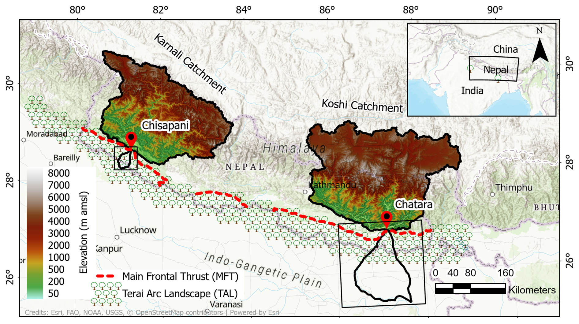
Figure 1Catchment areas of the Karnali and the Koshi river systems in the Terai, (upstream of, respectively, Chisapani and Chatara, where the rivers exit the Himalayan mountain chain) are of comparable size. The Karnali fluvial fan is ten times smaller than the Koshi fluvial fan.
Rivers in the Terai are crucial for both sustaining wildlife habitats that are home to species like the Bengal tiger (Chanchani et al., 2014; Wikramanayake et al., 2010, 1998), one-horned rhinoceros (Ghimire, 2020; Thapa et al., 2013), gharial crocodile (Vashistha et al., 2021), and elephants (Thapa et al., 2019), and supporting agriculture in the fertile Terai (Thapa and Tuladhar, 2021). Balancing these vital functions requires the sustainable management of Terai rivers and their surrounding landscapes.
The Karnali fluvial fan (Rakhal et al., 2021; Dingle et al., 2020a) is part of the Ghagra plain, which is a subregion within the Ganga Plain (Dingle et al., 2017, 2016; Goswami and Mishra, 2013; Lupker et al., 2012). After exiting the Himalayan mountain chain at Chisapani (Fig. 1), the Karnali River splits into two main branches (Rakhal et al., 2021): the eastern Geruwa branch and the western Kauriala branch. The channel bed transitions from being gravel-dominated to sand-dominated (Dingle et al., 2021; Blom et al., 2017) along each of the two branches (Dingle et al., 2020b, 2017). This abrupt gravel-sand transition is located where the sediment flux transported from upstream runs out of gravel and a gravel front progrades (Blom et al., 2017; Dingle et al., 2017; Parker and Cui, 1998; Paola et al., 1992). The two branches rejoin forming a confluence approximately 50 km downstream of the bifurcation, just upstream of the Kailashpuri Dam in India. The Geruwa branch flows through Bardiya National Park, a critical habitat for endangered wildlife, including tigers (Thapa and Tuladhar, 2021; Wikramanayake et al., 1998).
Discharge in the eastern (Geruwa) branch has declined in recent years (Roebroeck, 2022; Vashistha et al., 2021; Khanal et al., 2016), as has the flow into the Okhariya irrigation inlet located between the branches. Efforts to restore discharge by excavating small channels through sediment deposits at the upstream end of the Geruwa branch have resulted in only minor increases in flow. Similar interventions were required to maintain discharge at Okhariya. In contrast, the western (Kauriala) branch now conveys the majority of the Karnali River’s discharge. This redistribution of flow has affected both ecosystem functioning and wildlife in Bardiya National Park. Reduced discharge in the Geruwa branch has promoted the encroachment of shrub and woody vegetation (Vashistha et al., 2021), while Ganges River dolphins have migrated away from this protected, no-fishing branch in response to altered flow conditions (Vashistha et al., 2021; Khanal et al., 2016). This study investigates the ongoing shift in channel dominance on the Karnali fluvial fan in the Himalayan Terai.
A river can change its dominant flow path due to natural or anthropogenic factors. Natural controls include underlying geomorphology, such as the imprint of former channels in floodplain topography and sediment structure (Slingerland and Smith, 2004; Martin and Edmonds, 2023; Valenza et al., 2020), as well as present-day floodplain topography (Gearon et al., 2024) and hydrological regime (Wells and Dorr, 1987; Chowdhury et al., 2023; Blom et al., 2024). The sequence of flood events can further reorganize river beds by altering sediment transport and deposition during subsequent floods (Cload et al., 2026; Blom et al., 2024; Chowdhury et al., 2023; Mao, 2018). In addition, extreme events such as earthquakes may trigger abrupt or gradual shifts in flow paths (Chamberlain et al., 2024; Holbrook and Schumm, 1999).
Anthropogenic interventions are also important stressors on Terai river systems (Swarnkar et al., 2021; Bajracharya et al., 2018; Haddeland et al., 2014; Lutz et al., 2014; Magilligan and Nislow, 2005). Such interventions influence channel morphology and bifurcation dynamics (Gregory, 2006), for example through dams, irrigation offtakes, embankments, dredging, sediment nourishment, and land-use change. Dams typically increase low flows and reduce peak discharges, thereby decreasing overbank flooding and altering channel-floodplain connectivity (Magilligan et al., 2003). In addition, dams trap approximately 50 % of global river sediment, reducing downstream sediment supply and promoting channel incision (Vörösmarty et al., 2003; Schmidt and Wilcock, 2008). For example, narrowing of the Yamuna River in the western Terai has been linked to upstream dams and sediment mining since 2013 (Yadav et al., 2023). More broadly, expansion of agricultural and urban land at the expense of natural vegetation in tropical regions has accelerated runoff responses, increasing both flood peaks and sediment loads (Kayitesi et al., 2022).
Climate change is an additional stressor on Terai river systems. Rising temperatures increase atmospheric moisture and intensify precipitation, while earlier snowmelt in the upstream mountains enhances runoff. Together, these changes lead to higher river discharges, more frequent flooding, and longer-lasting peak flows, with significant impacts on agriculture and biodiversity (Bajracharya et al., 2018; Immerzeel et al., 2010; Lutz et al., 2014; Oki and Kanae, 2006; Pokhrel et al., 2026). These effects are likely to be amplified in basins already modified by human interventions such as dams and land-use change (Palmer et al., 2008).
This study aims to identify the causes of the decline in water discharge in the eastern (Geruwa) branch of the Karnali River fluvial fan. The following research questions are addressed: (a) how has discharge partitioning in the Karnali fluvial fan evolved over recent decades; (b) what geomorphic and sedimentary processes govern channel dominance on the fan; (c) to what extent do human interventions influence these dynamics; and (d) how does spatial variability in bed surface grain size modulate sediment routing and flow partitioning at the Karnali bifurcation.
To assess the relative roles of natural and human drivers, we compare the Karnali River with the more heavily altered Koshi River, a well-studied system in a similar setting in eastern Nepal (Wells and Dorr, 1987; Gautam and Acharya, 2012). We consider potential controls including anthropogenic interventions, climate change, and intrinsic fluvial processes. The analysis integrates catchment characteristics, hydrograph data, and flow duration curves. A Digital Elevation Model (DEM) is used to assess elevation patterns within the catchments and fluvial fans, while historical maps and satellite imagery are combined to evaluate changes in channel configuration and fan dynamics. In addition, spatial differences in surface grain-size distributions are analysed using local bed-surface images and associated image analysis, distinguishing grains with a major axis length larger than 20 mm. Temporal changes in bed level are quantified by differencing the composite Copernicus DEM (2011–2014) and the SRTM DEM (2000).
The paper is structured as follows. Section 2 describes the methods. Section 3 presents the hydrological characteristics of the two catchments. Section 4 examines fluvial fan characteristics and flow partitioning between the Geruwa and Kauriala branches. Section 5 analyzes channel dynamics (including sinuosity and braiding) and surface sediment in the bifurcation region. Section 6 discusses the findings, and presents a conceptual model for the shift in channel dominance. Section 7 concludes the study.
Here we explain our methods to analyze and compare (a) catchment and hydrological characteristics, (b) fan elevation and dynamics, and (c) channel and sediment dynamics in the Karnali and Koshi river systems. Two locations are key to our analysis: Chisapani, where the Karnali River exits the Himalayan mountain range, and Chatara, where the Koshi River transitions to the flatlands of Nepal and India (Fig. 1).
We assess the hydrological behavior of both river systems by analyzing the measured discharge time series from Chisapani (1962–2019) and Chatara (1977–2015). We define the area-averaged river discharge (qA) as the ratio of the measured water discharge or outflow at Chisapani and Chatara (Q) to the associated upstream catchment area (A). We compare flow duration curves, daily discharge, monthly-averaged discharge, and percentile discharges. Specifically, we analyze temporal trends of discharge values exceeded for 10 %, 50 %, and 90 % of the year, as minimum and maximum values are more susceptible to measurement errors.
To evaluate the impact of hydropower on discharge trends in both catchments, we compare periods before and after 2000, when hydropower in the Koshi catchment significantly expanded. In 2000 only five hydroelectric plants (larger than 1 MW capacity) were operational in the Koshi catchment according to data available from the Nepal Department of Electricity Development. By 2022 this number had increased to 28, and 76 plants with a license for construction, and 132 more under feasibility study. In contrast, the Karnali catchment remains relatively undeveloped (Shrestha and Paudyal, 1992). By 2022, it had only two operational hydropower plants, with 12 in construction, and 30 additional projects under feasibility study.
We use the ALOS World 3D 30 m-resolution elevation (AW3D30) data set to compute catchment area, average slope, stream frequency, and drainage density. For fan elevation analysis, we use the 30 m-resolution Copernicus DEM data set. Fan outlines and former channel courses are delineated using literature (Rakhal et al., 2021; Singh, 1971; Wells and Dorr, 1987), historical maps, and Landsat 4, 5, 7, and 8 satellite images. Maps of the Karnali system span 1785–1967, though those predating 1855 have coarse spatial resolution and cannot be georeferenced, yet help identify historical flow paths. The channel course since 1760 and maps of the Koshi system are derived from Chakraborty et al. (2010). We digitize channel courses from maps and satellite images using ArcGIS Pro 3.1.3.
To analyze deviations from the mean elevation decline along the fan, we define normalized elevation as the elevation along each cross-section minus the minimum elevation within that cross-section. Cross-sections are taken perpendicular to the fan's length from apex to toe, with a spacing of 500 m for the Karnali fan (50 km length) and 1600 m for the Koshi fan (160 km length).
We use 30 m-resolution Landsat images (1972–2021) to estimate discharge partitioning between the two branches of the Karnali system. Our analysis focuses on a 25 km reach downstream of the Chisapani bifurcation and upstream of tributary confluences with the Kauriala and Geruwa branches. We use the Google Earth Engine environment for this analysis. To quantify water cover, we select the first low-discharge image of each year with minimal cloud cover. We apply the Normalized Difference Water Index (NDWI) (McFeeters, 1996) to identify water-covered pixels in each branch, allowing us to compute the percentage of water cover. This percentage serves as a rough proxy for the discharge partition between the two branches. The fact that narrow channels cannot be identified from the coarse resolution satellite images does not significantly affect the results, as these small channels are typically inactive during low discharges. The irrigation inlet between the Kauriala and Geruwa branches, with a maximum capacity of 50 m3 s−1, is minor relative to the main channel and thus excluded from the discharge partitioning analysis.
We extend this analysis on discharge partitioning to high-discharge conditions using data from a recent field campaign where we measured the average daily water level at the Sattighat bridge (Kauriala) and the Kothiyaghat bridge (Geruwa), both approximately 30 km downstream of Chisapani, during the period between 7 November 2023 to 15 March 2025 using an Obscape radar level gauge. Water discharge in the two branches, as well as the discharge distribution between the branches, has been computed from these time series of measured water level, also under monsoon-dominated conditions, which is described in Appendix A.
We assess braiding and sinuosity of the Karnali River between 1990 and 2015 using Landsat 5, 7, and 8 imagery captured during low-discharge conditions to better observe channel dynamics. We quantify changes using dimensionless indices: the Braiding Index (BI) and Sinuosity Index (SI) following Friend and Sinha (1993), and the Sinuosity Dynamics (SD). The Braiding Index, BI, is defined as the ratio of the total channel length (LCtot) to the mid-channel length of the widest channel (LCmax):
The Sinuosity Index, SI, is defined as the ratio of mid-channel length of the widest channel, LCmax, to the linear length of the segment of the river under consideration, LR:
Sinuosity Dynamics, SD, is defined as the percentage of change of the Sinuosity Index in year n over two consecutive years:
We subdivide the Karnali system into segments of approximately equal length (Fig. 2), and compute the values of the three indices for each segment.
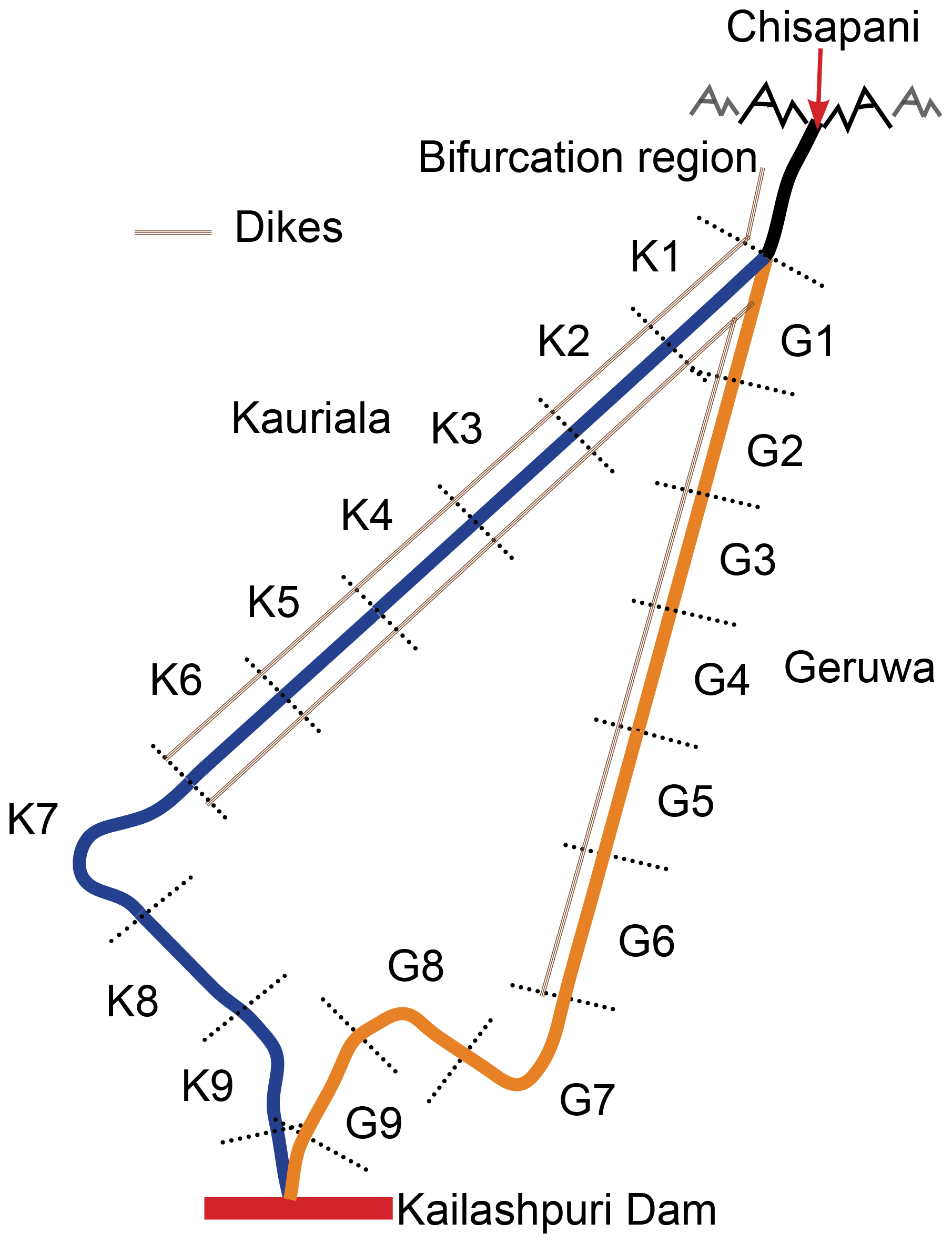
Figure 2The two Karnali branches are divided into nine segments, each about 5 km long. Blue sections represent the Kauriala branch, and orange ones the Geruwa branch. For each segment, we compute three indices: the Braiding Index, Sinuosity Index, and Sinuosity Dynamics.
We use NDWI imagery to delineate the channel network and to quantify both the length of the widest channel and the total channel length. During low-discharge conditions, NDWI enables identification of the widest flow-carrying channel, which we define as the main channel. Its length is used to compute braiding and sinuosity indices. Additional channels, including narrower or dry channels, are identified through visual interpretation of true-colour imagery to determine the total channel length within the study reach.
To assess temporal changes in bed level across the Karnali fan, we compare the 30 m Copernicus DEM (2011–2014) with the 30 m SRTM DEM (2000). These are the only suitable datasets available to capture elevation changes associated with the 2009 monsoon period. The SRTM DEM represents surface elevations from the 2000 mission, while the Copernicus DEM is derived from remote sensing data collected between 2011 and 2014. Channel networks are extracted from Landsat 5 and 7 imagery using NDWI for comparable low-discharge conditions at Chisapani in 2000, 2009 (pre-monsoon), and 2011.
Surface grain-size distributions are derived from bed-surface images collected at multiple locations across the fluvial fan during a field campaign in November 2023. Grain sizes are quantified using Segmenteverygrain (Sylvester et al., 2025), a Python-based tool for image-based sediment analysis.
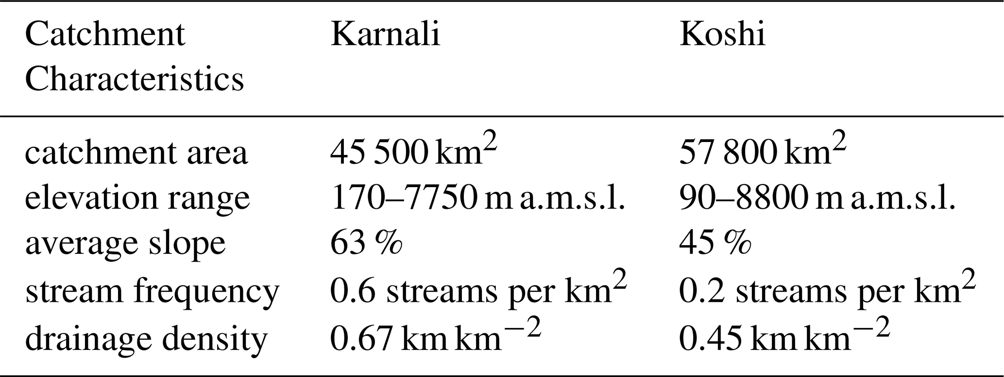
We have determined catchment characteristics in terms of catchment area, average slope, stream frequency, and drainage density (see Table 1). The catchment areas of the Karnali River (upstream of Chisapani) and the Koshi River (upstream of Chatara) are approximately 45 500 and 57 800 km2, respectively, implying that they are of the same order of magnitude.
Elevation of the Karnali River catchment varies from nearly 7750 m above mean sea level to 170 m a.m.s.l. at Chisapani, and that of the Koshi River varies from nearly 8800 to 90 m a.m.s.l. at Chatara. About 17 % of the Karnali River catchment and 28 % of the Koshi River catchment is above 5000 m a.m.s.l. The Karnali catchment is steeper than the Koshi catchment, with a 63 % versus a 45 % mean slope. We find that the Karnali catchment has a higher stream frequency than the Koshi, with 0.6 versus 0.2 streams per square kilometer, as well as a higher drainage density (0.67 versus 0.45 km km−2 for Koshi).
Seasonal discharge variation is similar in both river systems (Fig. 3a–b). Discharge is low during winter (December–April) and increases in late spring due to temperature-driven glacial melt. Monsoon precipitation further elevates discharge from June to September, resulting in a pronounced high-flow period typical of monsoon-dominated rivers.
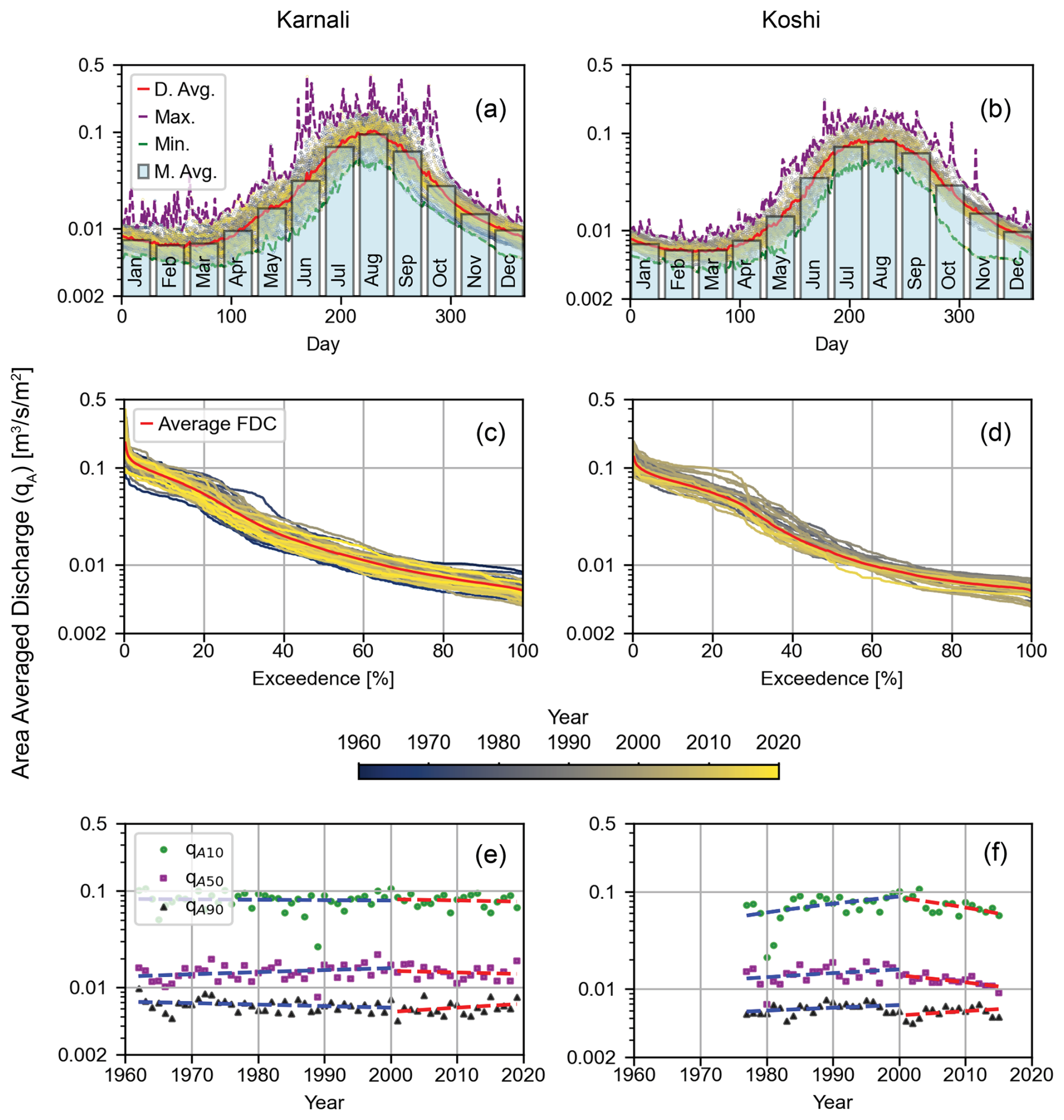
Figure 3Daily-average (D. Avg.), monthly-average (M. Avg.), maximum (Max.) and minimum (Min.) area-averaged discharge, qA, for (a) the Karnali system and (b) the Koshi system. Flow duration curves for the area-averaged discharge, qA, for (c) the Karnali and (d) the Koshi system. 10 %, 50 %, and 90 % values of the area-averaged discharge (qA10, qA50, and qA90) for (e) the Karnali and (f) the Koshi system.
The Karnali system exhibits a shorter high-discharge period and a slightly higher mean monthly discharge in August than the Koshi system. This difference can be attributed to spatial variations in rainfall: the eastern Koshi catchment receives more prolonged and higher total precipitation than the western Karnali catchment (Bookhagen and Burbank, 2010; Geddes, 1960; Khatiwada et al., 2016; Sinha et al., 2005). In the Karnali basin, peak discharge in August lags peak precipitation in July by approximately one month (Khatiwada et al., 2016).
Table 1Catchment characteristics of the Karnali River (upstream of Chisapani) and Koshi River (upstream of Chatara).
Maximum daily discharge shows greater variability in the Karnali River than in the Koshi system (Fig. 3a–b). This likely reflects the steeper topography, higher stream frequency, and greater drainage density of the Karnali catchment, which together shorten runoff response times to rainfall.
The flow duration curve of the Karnali system remains relatively stable over time (Fig. 3c, e), whereas area-averaged discharge in the Koshi system has decreased since 2000 (Fig. 3d, f). This decline is consistent with the rapid expansion of hydropower development in the Koshi basin over the same period (Fig. 4).
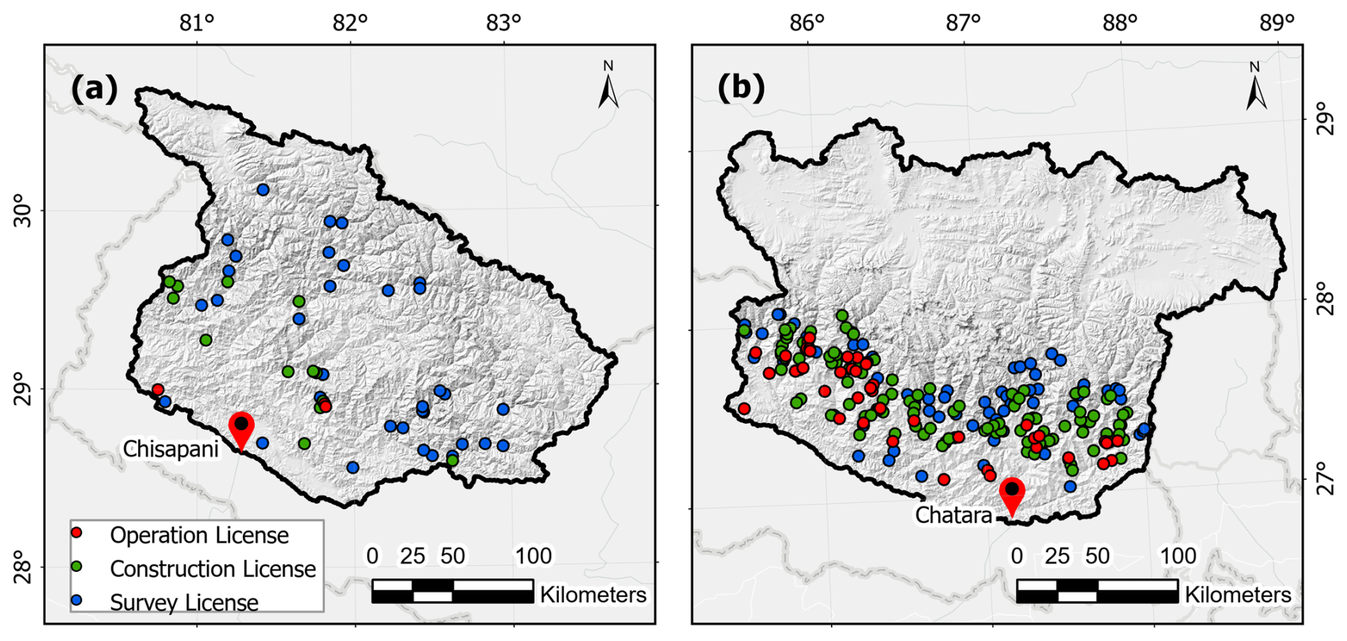
Figure 4Hydropower stations operational as of 2022 (red dots), projects with a construction permit (green dots), and projects under feasibility study (blue dots) in (a) the Karnali catchment and (b) the Koshi catchment.
The Koshi fan is ten times larger than the Karnali fan (Figs. 1 and 5a–b): the Karnali fan has an area of about 1000 km2 and the Koshi fan has an area of about 10 000 km2. This difference in fan size may be due to a difference in sediment yield from the upstream catchment and geological constraints. Sediment yield of the Karnali at Kailashpuri Dam (B.K. Ghat station) is approximately 1456 t km−2 yr−1 or 64 Mt yr−1 (Sinha et al., 2005), whereas the sediment flux in the Koshi River at Chatara equals 1915 t km−2 yr−1 or 101 Mt yr−1 (Sinha et al., 2023, 2019). The higher sediment yield of the Koshi basin shows its potential to deposit larger quantities of sediment in its fan than the Karnali. Dingle et al. (2016) find that the basins in the west subside more slowly than in the east, implying that the smaller Karnali fan area is not explained by a higher subsidence rate. Furthermore, they note that the lower subsidence rates in the west are associated with entrenched river systems.
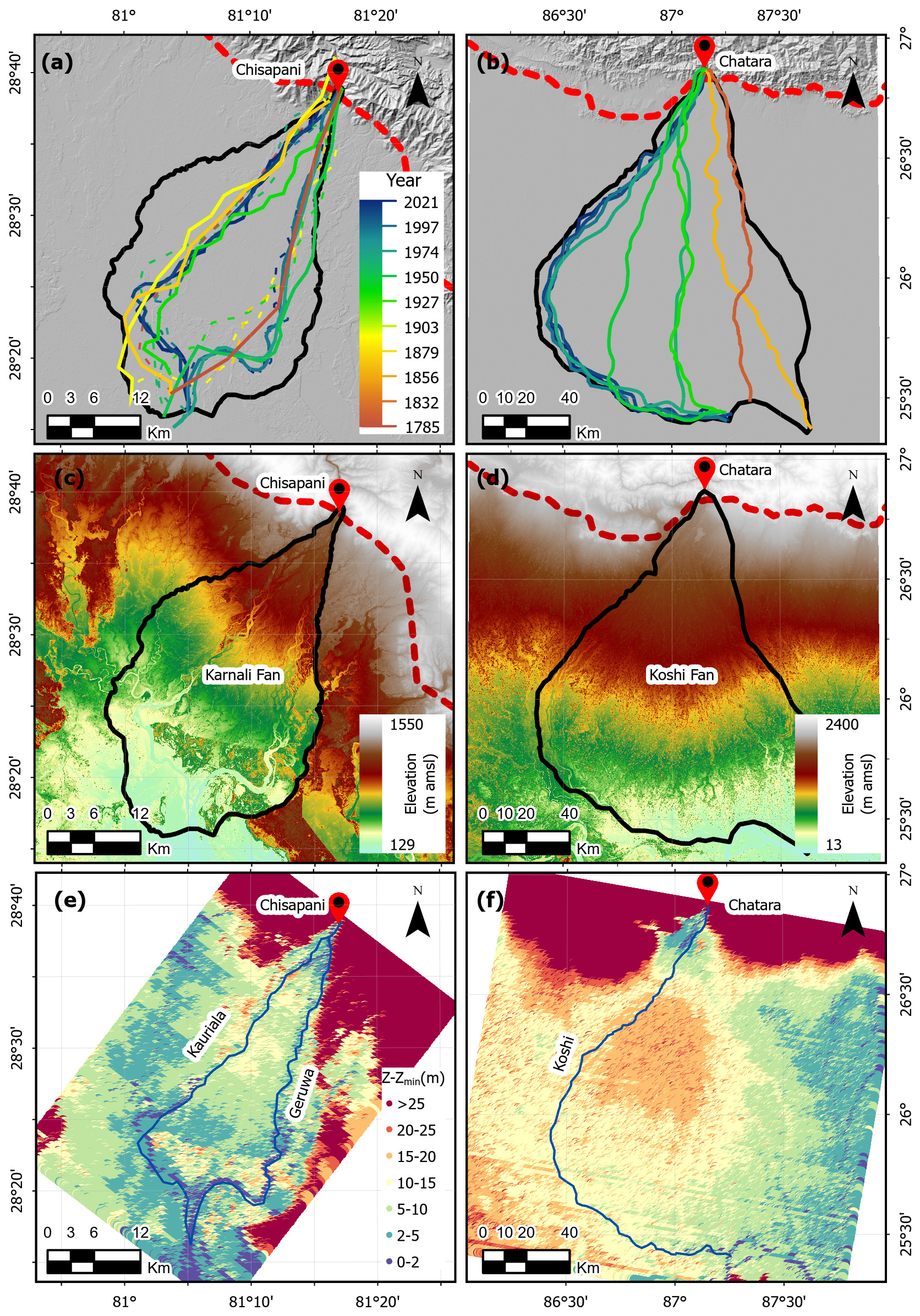
Figure 5Course of branches over (a) the Karnali fan and (b) the Koshi fan at various times. Solid lines indicate dominant branches and dashed lines represent smaller branches. Absolute elevation over (c) the Karnali fan and (d) the Koshi fan. Normalized elevation for (e) the Karnali fan and (f) the Koshi fan shows deviation from the mean elevation decline along the fan.
Figure 5 shows that the Karnali River has functioned as a two-branch system since at least 1785, with dominance shifting between the branches. In contrast, the Koshi River has remained a single-branch system, though its main channel has migrated over time (Chakraborty et al., 2010). Our earliest map of the Karnali system dates to 1785, showing Geruwa as the dominant branch. By 1861, 1893, and 1906, the Kauriala branch had become the larger of the two (Fig. 5a). From 1933 onward, Geruwa resumed dominance until 2009.
The most recent shift in channel dominance followed a double-peaked monsoon in 2009 (Khanal et al., 2016; Vashistha et al., 2021; Roebroeck, 2022; Cload et al., 2026). NDWI analysis of satellite imagery under low-flow conditions (when cloud cover is limited and channels are clearly visible) shows that, since 2009, the water-covered area of the Kauriala branch has gradually increased at the expense of the eastern Geruwa branch (Fig. 6a), which was first indicated by Roebroeck (2022) and later confirmed by Cload et al. (2026). Additional evidence of this shift in flow partitioning includes a reduction in discharge to the Okhariya irrigation inlet, located between the branches, and the migration of Ganges River dolphins away from the protected, no-fishing Geruwa branch in response to altered flow conditions (Vashistha et al., 2021; Khanal et al., 2016). Attempts to restore discharge to the Geruwa branch through excavation of small channels through deposited sediment at its upstream end and near the Okhariya inlet were largely unsuccessful. Together, these observations indicate a progressive increase in Kauriala discharge and a corresponding decline in Geruwa discharge since 2009.
Several lines of evidence suggest that this shift also persists under higher discharge conditions. Water-level measurements in both branches between November 2023 and March 2025 extend the analysis to moderate monsoon flows, including the 2024 monsoon peak (approximately 10 000 m3 s−1). Discharge at Chisapani was provided by the Department of Hydrology and Meteorology, Nepal. The fraction of discharge entering the Geruwa branch ranges from about 5 % during low flows to approximately 17 % under higher flows (Appendix A). In contrast, Dingle et al. (2020b) reported that the Geruwa branch conveyed about 50 % of the Chisapani discharge during a moderate monsoon event in August 2017 (approximately 4500 m3 s−1). This comparison indicates that the reduction in Geruwa discharge is not limited to low-flow conditions but also occurs during monsoon flows.
Independent support comes from changes in floodplain vegetation. Reduced discharge in the Geruwa branch has promoted the expansion of shrub and woody vegetation between 2010–2019 (Vashistha et al., 2021). Bijlmakers et al. (2023) show that higher peak discharges at Chisapani are associated with increased vegetation removal in the Geruwa floodplain, suggesting that grassland cover can serve as a proxy for hydro-morphodynamic activity. Since 2009, grassland cover has expanded at the expense of bare sediment and open water, indicating reduced floodplain reworking. This trend is consistent with field observations during recent monitoring campaigns and with reports from Bardiya National Park staff and local residents, who describe a decline in flooded areas and an increase in vegetation cover.
These observations collectively indicate that discharge in the Geruwa branch has decreased over time under both low- and moderate-monsoon conditions. We note that no data are available to assess changes in discharge partitioning during more extreme monsoon events.
Both fluvial fans exhibit a typical decline in elevation along their length (Fig. 5c, d). A geological constraint along the eastern boundary of the Karnali fan is marked by a sharp rise in elevation (Fig. 5c), while the Koshi fan shows an elevation difference along its southern boundary (Fig. 5d). These boundaries appear to have restricted the fans' expansion in these directions (Fig. 5a, b).
Normalized elevation (in Fig. 5e–f) illustrates deviation in local topography from the typical elevation decline along the fan (Sect. 2). It is defined as the elevation along each cross section minus the minimum elevation within that cross section, with cross-sections taken perpendicular to the fan length from apex to toe. This analysis reveals that the central part of the Koshi fan is elevated (Fig. 5f), resulting in a convex-up cross-sectional profile (Chakraborty et al., 2010). Such profiles restrict lateral channel migration through bank erosion, making avulsion the dominant mechanism for channel course changes.
Figure 5f suggests that a monsoon-driven avulsion just downstream of Chatara could redirect the channel toward the eastern part of the fan. This is supported by the 2008 breach in the eastern embankment and the subsequent avulsion upstream of the Koshi Barrage (Dingle et al., 2016). During this event, the Koshi River temporarily reoccupied its paleochannels and floodplains until the embankment was repaired in 2009 (Sinha et al., 2014).
Similarly, though less pronounced, the central part of the upper Karnali fan is slightly elevated compared to its two branches (Fig. 5e), which was indicated by Dingle et al. (2016) to be the result of its low subsidence rate. This elevation difference, possibly aided by current embankments, limits flow from occupying the central part of the fan.
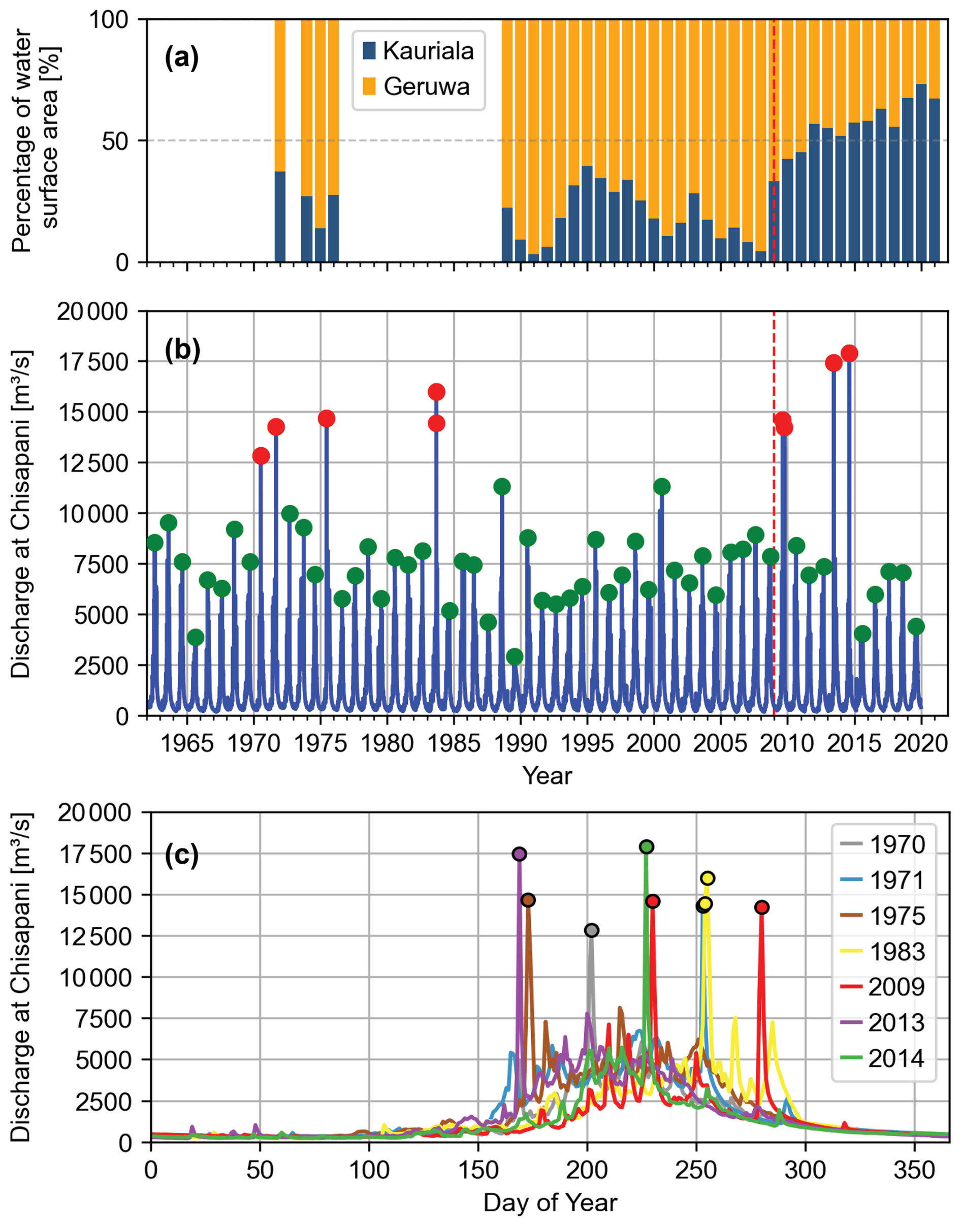
Figure 6Water-surface cover and hydrograph characteristics in the Karnali system: (a) relative water-surface cover for the Kauriala and Geruwa branches of the Karnali River, as obtained from satellite images under low-discharge conditions according to Roebroeck (2022); (b) hydrograph at Chisapani with red circles indicating peak discharge values over 12 500 m3 s−1 and green circles annually-maximum values; and (c) annual hydrographs for years with high monsoon-driven peak discharges over 12 500 m3 s−1.
Here we investigate channel dynamics and surface sediment in the two branches of the Karnali River in relation to the shift in channel dominance since 2009.
The Kauriala branch is embanked on both its western and eastern sides, limiting the floodplain area and restricting channel dynamics and migration. The Geruwa branch remains mostly unembanked along its eastern bank, where it borders Bardiya National Park. This absence of embankment has preserved Geruwa's dynamic character.
Figure 7 shows Sinuosity and Braiding Indices and Sinuosity Dynamics for the segments of the two branches (Fig. 2). We observe that sinuosity does not significantly vary spatially (Fig. 7a). Sinuosity change in Segment 7 of the Kauriala branch is relatively high where it migrates laterally in response to a tributary (Fig. 7b).
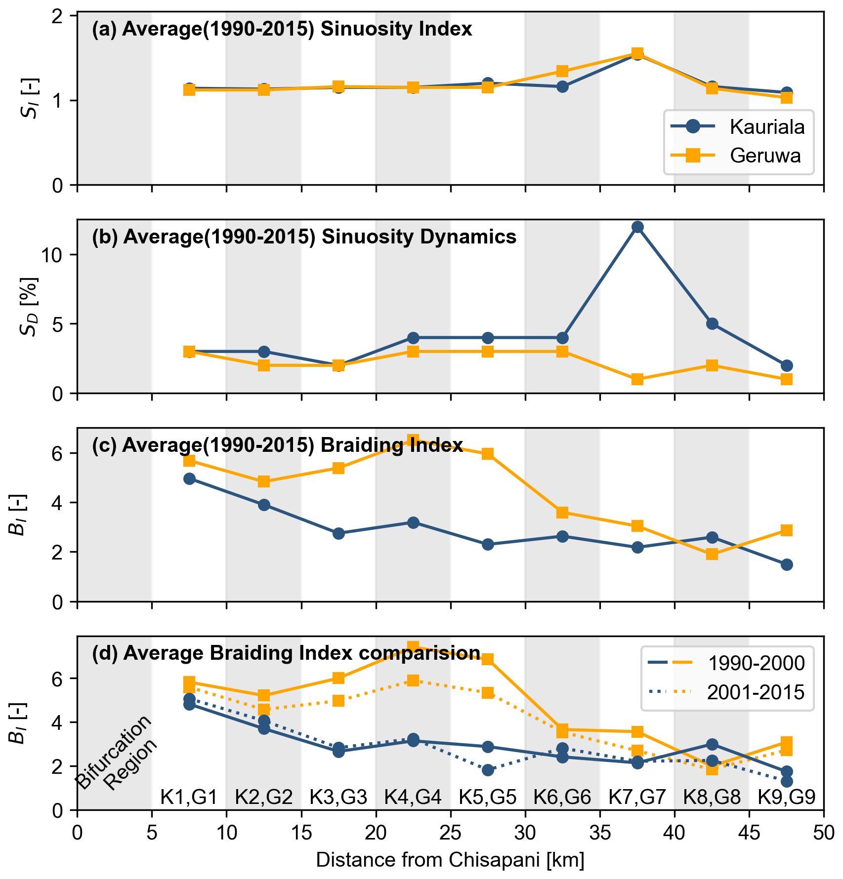
Figure 7Sinuosity and braiding indices for segments of the Kauriala and Geruwa branches over the fluvial fan of the Karnali River: (a) Sinuosity Index, (b) Sinuosity Dynamics, and (c) Braiding Index, all averaged over the period 1990–2015. (d) Braiding Index for two periods, 1990–2000 and 2001–2015. Segments are defined in Fig. 2, and river km starts at Chisapani with a dynamic bifurcation region right downstream of Chisapani.
Braiding intensity decreases downstream (Fig. 7c), with the highest values near the bifurcation, where channel and floodplain width span several kilometers. This ample space allows for active channel migration and switching. The downstream decline in braiding intensity is largely due to embankments (Kafle, 2021; Venkateswaran et al., 2015) along the central and lower fan. Additionally, backwater effects from Kailashpuri Dam likely reduce channel dynamics in the lower reaches.
The braiding intensity of Geruwa generally exceeds that of Kauriala (Fig. 7c), likely due to the absence of embankments along Geruwa's eastern bank. Over time, the braiding intensity of the Geruwa branch appears to decline slightly (Fig. 7d), which may be linked to its decreasing share of upstream discharge.
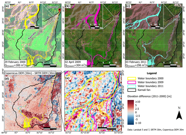
Figure 8 presents land cover and stream networks derived from satellite imagery for 2000, 2009 (pre-monsoon), and 2011, all under comparable low-discharge conditions at Chisapani. In 2000, the Geruwa branch conveyed a substantial portion of the discharge. At least two channels connected the upstream Karnali River to the Geruwa branch, originating from an outer bend at Dolphin Point (Fig. 8a).
By 2009, prior to the double-peaked monsoon, an additional channel had formed near the eastern fan boundary (Fig. 8b). By 2011, this channel had disappeared, and only a single, narrower channel continued to supply flow to the Geruwa branch (Fig. 8c). Consequently, a larger share of the Chisapani discharge was routed through the Kauriala branch. The loss and narrowing of these channels between 2009 and 2011 indicate reduced connectivity to the Geruwa branch under low-flow conditions, consistent with sediment deposition in the channel originating from the Karnali outer bend at Dolphin Point.
To assess the role of sediment deposition, we analyse temporal changes in surface elevation in the bifurcation region. Elevation differences are derived by comparing the Copernicus DEM composite (2011–2014) with the SRTM DEM (2000). The results show that the upstream region of the Geruwa branch was elevated in 2011–2014 relative to 2000 (Fig. 8d–e). As the study area is largely unvegetated, canopy effects do not significantly affect the DEM-based elevation estimates. These findings support the interpretation that reduced discharge in the Geruwa branch is associated with sediment deposition in its upstream reach.
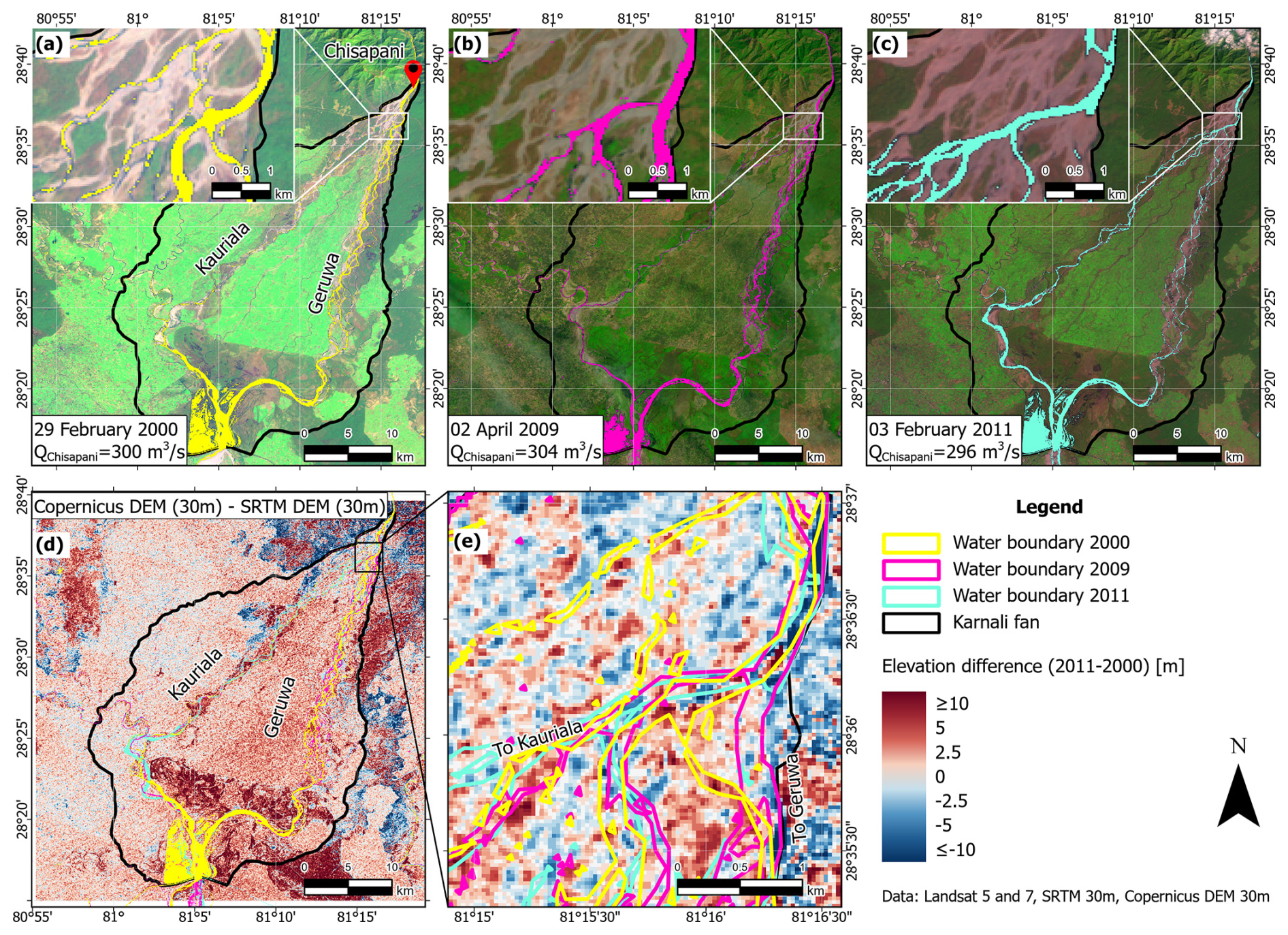
Figure 8Wetted surface area indicating river channels across the Karnali fluvial fan in the years (a) 2000, (b) 2009 (before the double monsoon peak), and (c) 2011. Data relate to low discharge conditions: 300 m3 s−1 in 2000, 304 m3 s−1 in 2009, and 296 m3 s−1 in 2011. The inset at the top-left corner of each map shows the Dolphin Point bend right upstream of where the Geruwa branch takes off from the Karnali River. (d) Difference in surface elevation across the Karnali fan between 2011–2014 (Copernicus DEM) and 2000 (SRTM DEM); (e) Inset of the elevation difference map at the Dolphin Point region and upstream end of the Geruwa branch with river channel outlines for the years 2000, 2009, and 2011.
Figure 9 shows spatial variation in bed-surface grain size in the Karnali bifurcation region. Notably, Location 3 near Dolphin Point, the outer bend where the Geruwa branch originates, contains exceptionally coarse material, ranging from coarse gravel to boulders up to 50 cm in diameter (Fig. 10). Similar grain-size distributions have been reported by Cload et al. (2026).
The presence of coarse sediment at the outer bend is consistent with bend sorting (Baar et al., 2018; Parker and Andrews, 1985; Ikeda et al., 1987), whereby secondary (helical) flow and the transverse bed slope direct coarse material toward the outer bend, while finer sediment is transported toward the inner bend. When a downstream channel bifurcates from an outer bend, as is the case for the Geruwa branch, this mechanism promotes the routing of coarse sediment into that branch (Chowdhury et al., 2026, 2023; Blom et al., 2024; Frings and Kleinhans, 2008). If the supplied sediment is too coarse to remain mobile, it tends to deposit in the upstream reach of the downstream branch (Blom et al., 2024; Chowdhury et al., 2023).
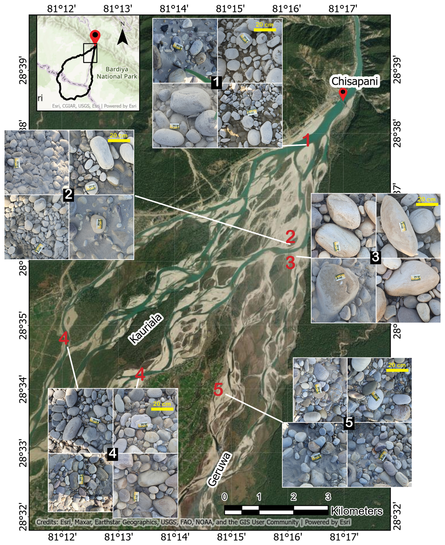
Figure 9Impression of spatial variation of bed surface grain size over the Karnali bifurcation region. Surface images were taken during a field campaign in 2023.
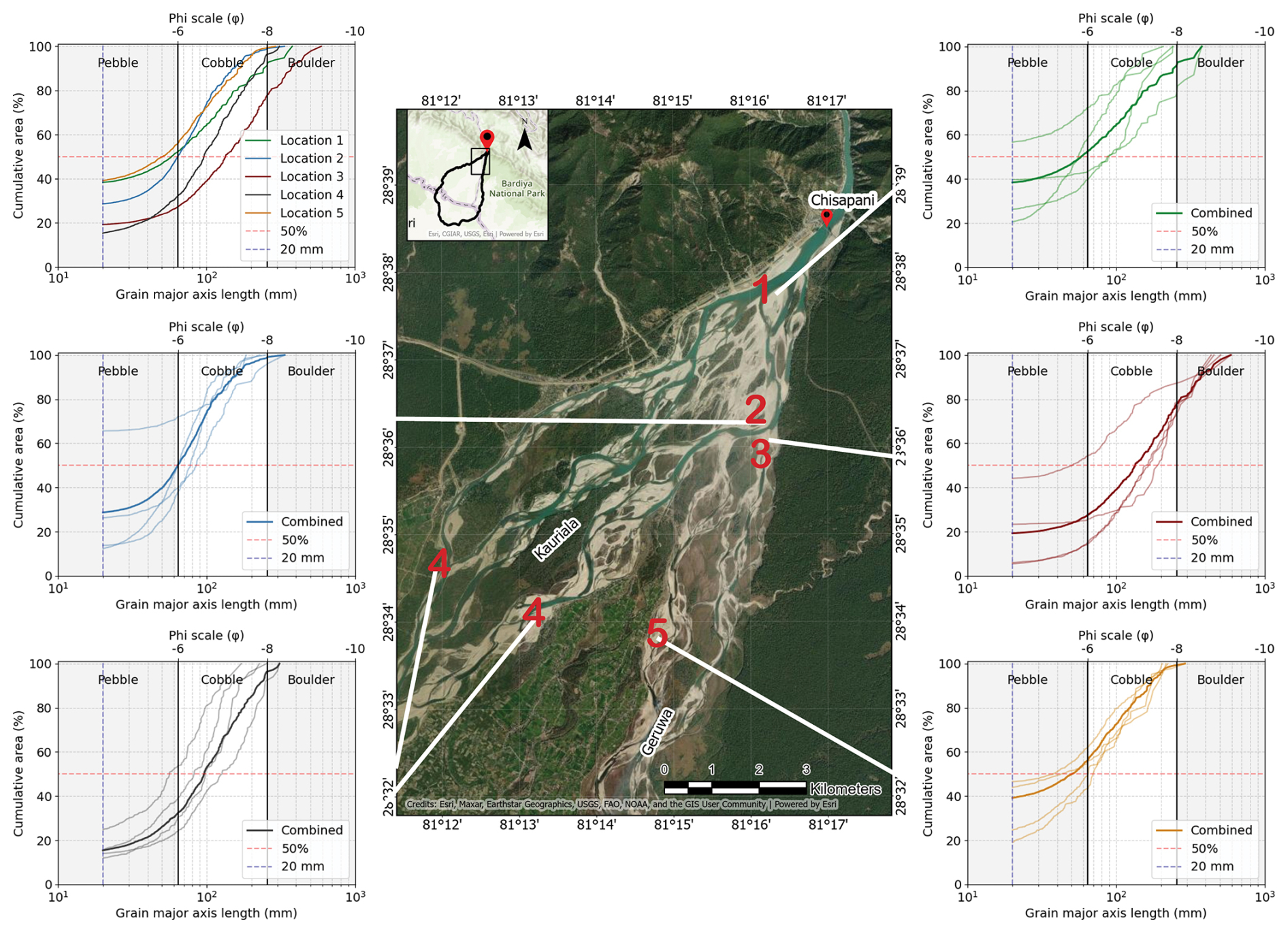
Figure 10Grain size distributions of the surface sediment at various locations of the Karnali bifurcation region (Fig. 9), obtained from image analysis. Only grains with a major axis length larger than 20 mm could be distinguished.
Based on the combined evidence from elevation change and sediment characteristics, we propose that the extreme 2009 monsoon mobilized and supplied coarse sediment which, through bend sorting, was preferentially routed into the Geruwa branch from the upstream outer bend. Due to limited mobility, this material was deposited in the upstream reach of the Geruwa branch, forming a sediment plug (Fig. 11). This deposit likely initiated the subsequent gradual decline in discharge into the Geruwa branch.
A recent study by Cload et al. (2026) attributes the shift in channel dominance on the Karnali fluvial fan to surface sediment reworking associated with armor break-up during the first peak of the 2009 monsoon, followed by redistribution during the second peak. While this mechanism may have contributed to enhanced sediment mobility, we find no evidence that surface sediment remains immobile within a single peak event, and armor break-up is not restricted to double-peaked floods (Wang et al., 2021; Vericat et al., 2006). Moreover, sediment reworking depends not only on local armoring but also on the upstream sediment supply, which is substantial during monsoon conditions in systems such as the Karnali River (Quick et al., 2023). These considerations suggest that coarse sediment supply and routing, rather than solely armor break-up dynamics, played a key role in driving the observed shift.
In summary, we propose a self-reinforcing mechanism similar to that described by Blom et al. (2024): (a) coarse sediment supplied during the extreme 2009 monsoon was routed into the Geruwa branch by bend sorting at a Karnali River outer bend; (b) this material deposited in the upstream reach of the Geruwa branch, raising the bed level; (c) the resulting reduction in conveyance decreased discharge into the branch; (d) reduced discharge further limited sediment mobility; and (e) continued deposition during subsequent floods reinforced the blockage. Future monitoring of bed-level change and surface sediment dynamics could further substantiate this interpretation.
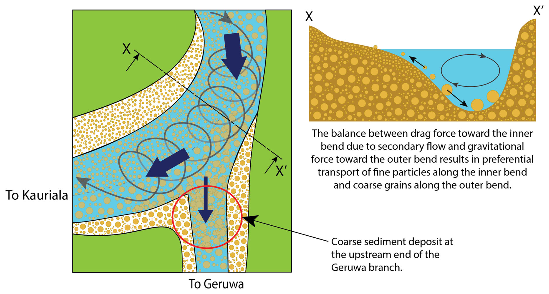
Figure 11Illustration of bend sorting mechanism leading to a gradual decrease of the Geruwa discharge and shift in channel dominance.
Our findings suggest that sediment supplied to the Geruwa branch during monsoon conditions is either too coarse or too abundant to be efficiently transported downstream, leading to progressive deposition and reduced discharge. Similar mechanisms have been proposed for shifts in discharge partitioning in the Rhine River (Blom et al., 2024; Chowdhury et al., 2023). An important question is whether the Karnali fluvial fan is evolving toward a single-branch system, as observed in the Koshi River. This is particularly relevant because the Geruwa branch supplies freshwater to Bardiya National Park, a key habitat for endangered species. Since 2022, low flows in the Geruwa branch have been maintained through excavation, highlighting its reduced natural conveyance. Our study suggests a bend-bifurcation coupling in which outer-bend bifurcation geometry promotes preferential routing of coarse sediment into Geruwa branch through bend sorting. When sediment supply exceeds transport capacity, this leads to upstream deposition, reduced conveyance, and further discharge reduction in the Geruwa. Our analysis shows repeated historical shifts in dominance between the Kauriala and Geruwa branches. Channel dominance may alternate as upstream planform geometry evolves. A reconfiguration in which the Kauriala branch originates from an outer bend could therefore reverse the present discharge partitioning.
We do not attribute the observed shift primarily to human interventions, which remain limited. Although both branches are embanked (except for the eastern Geruwa bank), these structures do not appear to have directly altered the recent redistribution of flow. However, they may still influence larger-scale adjustments such as avulsion following progressive channel clogging. In principle, interventions targeting the bend geometry near Dolphin Point could affect sediment routing into the Geruwa branch, but the effectiveness of such measures is highly uncertain given the system’s monsoon-driven dynamics and likely requires continuous maintenance.
Over the past century, several major earthquakes have affected the Terai region, including the Bihar-Nepal (1934), Udaypur (1988), and Gorkha (2015) events. These events can substantially increase coarse sediment supply through landslides and hillslope destabilisation (Marc et al., 2019; Lin, 2018). While fine sediment is rapidly evacuated, coarse deposits may persist for decades to millennia and are gradually reworked downstream. The downstream expression of this signal remains debated (Dadson et al., 2004; Hovius et al., 1997; Dingle et al., 2017), but such events may have contributed to a temporal increase in coarse sediment availability in the Karnali system. Combined with the extreme double-peaked 2009 monsoon, this may have enhanced coarse sediment delivery to the bifurcation region and promoted sediment deposition and plug formation in the Geruwa branch, consistent with the bend-bifurcation feedback mechanism proposed here. Further research is needed to quantify these effects.
Planned hydropower development is expected to reduce discharge and sediment variability by dampening flood peaks and trapping coarse sediment (Magilligan et al., 2003). This will likely stabilize flow and reduce the probability of future channel dominance shifts. In contrast, climate change is projected to increase flood magnitude and frequency in the Karnali basin (Dahal et al., 2020; Pradhananga et al., 2025; Pink et al., 2025), which would enhance sediment mobility in the absence of regulation. Under regulated conditions, however, such extremes may instead promote incision or reinforce a single dominant channel. The net outcome will depend on the interaction between climate forcing and flow regulation.
The stability of river bifurcations remains debated, with studies reporting stable, unstable, or multiple equilibrium states (Edmonds and Slingerland, 2008; Kleinhans et al., 2013; Schielen and Blom, 2018). Despite this diversity, bifurcation behavior is governed by nonlinear feedbacks between discharge partitioning, sediment transport, and bed-level adjustment. Small perturbations can therefore trigger self-reinforcing changes such as channel deepening or blockage (Blom et al., 2024; Bolla Pittaluga et al., 2003; Wang et al., 1995). These dynamics operate across scales from local sediment sorting to basin-scale sediment supply, making it difficult to distinguish transient from persistent states due to long adjustment times. Human interventions may further mask intrinsic morphodynamic behavior by altering discharge and sediment partitioning (Mendoza et al., 2019). In the Karnali system, the observed shift is consistent with such feedback-driven instability, but its long-term trajectory remains uncertain.
Our results support a coupled bend-bifurcation feedback in which sediment routing, channel geometry, and discharge partitioning interact to produce self-reinforcing channel change. Outer-bend bifurcation geometry promotes coarse sediment delivery via bend sorting, leading to deposition when sediment supply exceeds the transport capacity. This reduces conveyance, lowers discharge, and further enhances deposition, driving progressive channel shutdown.
More broadly, channel dominance in multi-thread fluvial fans emerges from the interaction between planform geometry and sediment sorting processes rather than discharge partitioning alone. While our observations provide evidence for this mechanism in the Karnali system, whether such configurations represent transient adjustments or longer-term dynamic equilibria remains unclear, particularly in data-scarce environments. Numerical modelling and long-term monitoring of sediment and bed-level dynamics are required to test the generality of this mechanism.
This study investigated recent changes in channel dominance on the Karnali fluvial fan, with a focus on discharge partitioning, controlling processes, and their sensitivity to sediment characteristics and external forcing.
Discharge partitioning has shifted over the past decade from a relatively balanced bifurcation toward a strongly asymmetric system dominated by the Kauriala branch. Since the double-peaked monsoon season in 2009, the Geruwa branch has experienced a persistent decline in discharge under both low-flow and moderate-monsoon conditions.
This shift can be explained by a coupled bend-bifurcation feedback in which planform geometry controls sediment routing and channel adjustment. Planform geometry with a bifurcate taking off from an outer bend, here the Geruwa branch, promotes preferential routing of coarse sediment into that bifurcate via bend sorting along the upstream bend. Following the extreme 2009 monsoon event, sediment supply exceeded transport capacity, leading to deposition in the upstream reach of the Geruwa branch. This reduced conveyance and triggered progressive discharge reduction, which further limited sediment mobility and reinforced continued aggradation. This self-reinforcing mechanism provides a consistent explanation for the observed channel adjustment.
Human interventions appear to play a limited direct role in the observed changes. Although embankments are present along parts of both branches, they do not explain the timing or magnitude of the post-2009 shift. Their influence on longer-term adjustments such as avulsion or system recovery, however, cannot be fully excluded.
Spatial variability in bed surface grain size modulates sediment routing at the bifurcation. Preferential transport of coarse sediment along the outer-bend (i.e., bend sorting) within the bifurcation zone coarsens the outer bend bed surface and enhances coarse sediment delivery into the Geruwa branch, increasing the likelihood of local deposition and reinforcing flow redistribution between branches.
Overall, channel dominance on the Karnali fluvial fan emerges from nonlinear interactions between planform geometry, sediment sorting, and discharge partitioning, rather than from discharge alone. The post-2009 evolution is best interpreted as a morphodynamic response to bend-bifurcation coupling triggered by the extreme double-peaked monsoon conditions.
While the proposed mechanism is supported by field observations, remote sensing, and topographic analysis, the long-term development of the system remains uncertain. Further work combining process-based modelling and long-term monitoring of sediment and bed-level dynamics is required to test whether the Karnali bifurcation is evolving toward a new equilibrium or, as part of a dynamic equilibrium, continuing to adjust through persistent shifts in channel dominance.
In 2023 we installed two water level monitoring stations in the downstream reaches of the Kauriala and Geruwa branches at the Sattighat and Kothiyaghat bridges, respectively, approximately 30 km downstream of Chisapani. Based on these data, we have determined daily water discharges in the two branches over the period between November 2023 and March 2025, as well as their ratio.
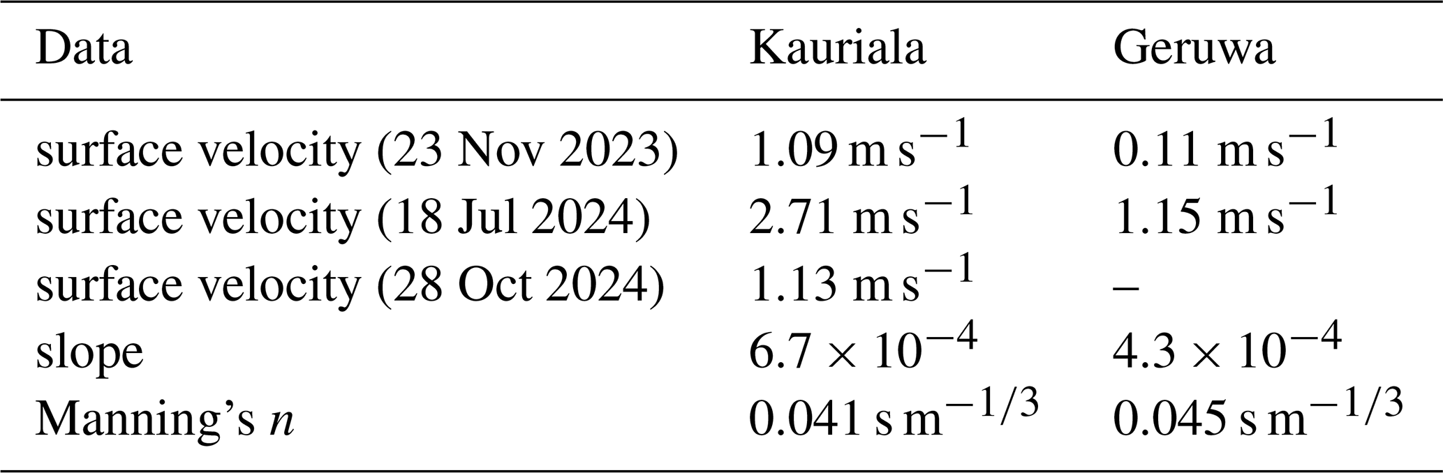
To this end, we measured cross-sectional profiles at both monitoring stations (Fig. A1) using sonar and Real-Time Kinematic (RTK) surveying, and assumed the profiles to remain constant over time. We have calibrated Manning's n using measured data on surface water velocity at various times:
where n denotes the Manning coefficient, v is the average flow velocity taken as 0.85 of the measured surface velocity (Biggs et al., 2023; Rantz, 1982), R is the hydraulic radius at a given depth calculated as the ratio of flow area to wetted perimeter, and S is the bed slope. We used surface water slope from the FABDEM derived from the Copernicus DEM (2011–2015) (Hawker et al., 2022) as a proxy for the bed slope. Surface velocity measurements were obtained using the float method.
The water discharge, (Q), in each branch corresponding to the measured water level was calculated using Manning's equation as:
where A is the flow area.
Table A1Parameters used for calibrating Manning's n coefficient at the water level monitoring stations in the Kauriala and Geruwa branches.
In addition, we have analyzed the Karnali discharge data at Chisapani (located right upstream of the Karnali bifurcation) over the same period. These discharge data at Chisapani were made available to us through the Department of Hydrology and Meteorology, Nepal. We have analyzed the ratio of the water discharges in the two branches as a function of the water discharge at Chisapani (Fig. A2). The Kauriala discharge is 20 times as large as the Geruwa discharge under low flows, and approximately 5 times as large as the Geruwa discharge under high flows.
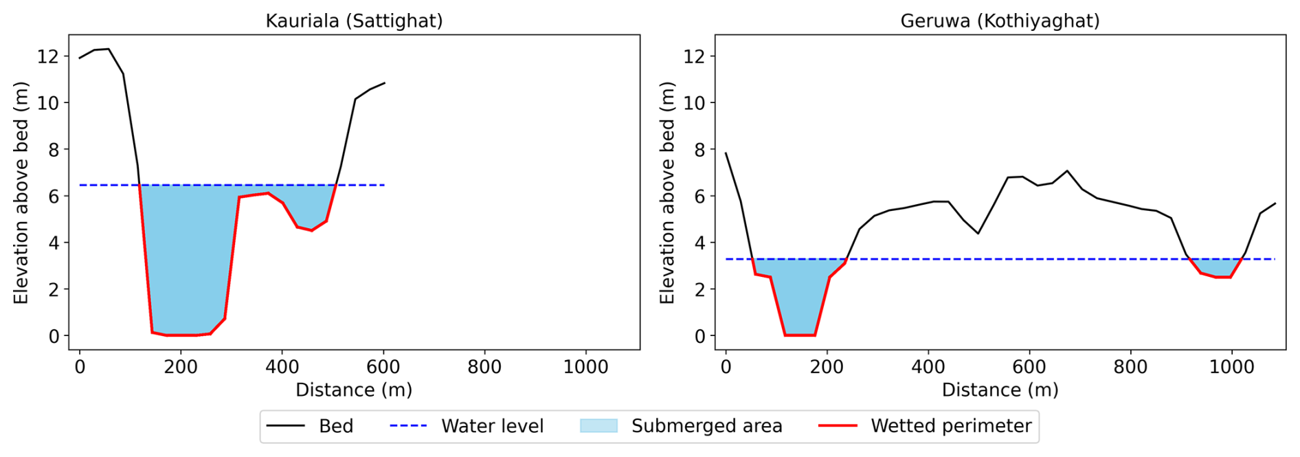
Figure A1Measured cross-sectional profiles at the water level monitoring stations in the Kauriala and Geruwa branches, used to calculate the discharge from measured water level. Water level at 18 July 2024 is indicated as an example.
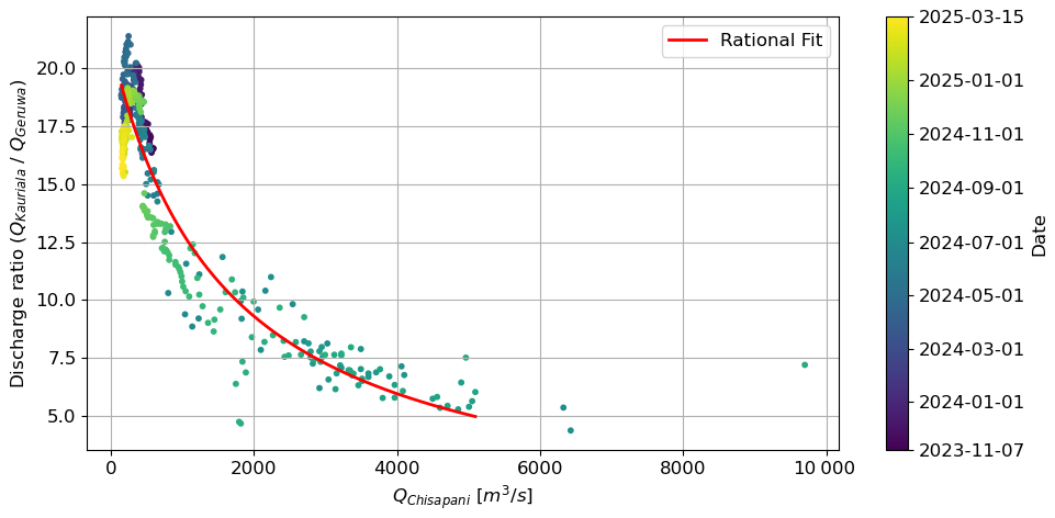
Figure A2Ratio of Kauriala to Geruwa discharge against the Chisapani discharge. Data originate from the period between 7 November 2023 to 15 March 2025. Water discharge in the two downstream branches was computed from time series of measured water level at Sattighat Bridge (Kauriala) and Kothiyaghat Bridge (Geruwa), both approximately 30 km downstream of Chisapani. Chisapani discharge over the same period was provided by the Department of Hydrology and Meteorology in Kathmandu, Nepal. Measured data include the 2024 monsoon cycle with a peak discharge of approximately 10 000 m3 s−1.
Discharge time series for Chisapani (1962–2019) and Chatara (1977–2015) were obtained from the Department of Hydrology and Meteorology in Kathmandu, Nepal. Locations of hydropower stations with their license status is available on the website of the Department of Electricity Development (DoED), Nepal. In particular, data for hydropower stations with a survey license has been obtained from https://doed.gov.np/pages/hydromorethan1/ (last access: 9 November 2026), those with a construction license from https://doed.gov.np/pages/clhydromorethan1/ (last access: 9 November 2026), and with an operation license (operating power plants) from https://doed.gov.np/pages/powerplantsmorethan1/ (last access: 9 November 2026). AW3D30 (https://doi.org/10.5069/G94M92HB, Japan Aerospace Exploration Agency, 2021), Copernicus DEM (https://doi.org/10.5069/G9028PQB, European Space Agency, 2024) and SRTM DEM (https://doi.org/10.5069/G9445JDF, NASA Shuttle Radar Topography Mission (SRTM), 2013) are open source DEM data obtained from OpenTopography repository (https://opentopography.org, last access: 9 November 2026). Landsat images were obtained from the Google Earth Engine repository (https://earthengine.google.com/, last access: 9 November 2026). Historical maps were obtained from the David Rumsey Map Collection (https://www.davidrumsey.com, last access: 9 November 2026).
KG, TB, and AB jointly conceptualized and designed the study. KG and TB planned the field campaigns. KG and MW collected the field data. KG and MR performed the data analysis. KG and AB drafted the manuscript. All authors reviewed, edited, and approved the final version. AB and TB secured the funding and provided overall supervision.
The contact author has declared that none of the authors has any competing interests.
Publisher's note: Copernicus Publications remains neutral with regard to jurisdictional claims made in the text, published maps, institutional affiliations, or any other geographical representation in this paper. The authors bear the ultimate responsibility for providing appropriate place names. Views expressed in the text are those of the authors and do not necessarily reflect the views of the publisher.
We acknowledge Mo de Jong for her assistance in acquiring the field data. We thank staff of the National Trust for Nature Conservation (NTNC) Bardiya Conservation Program and Bardiya National Park, Punaram Chaudhary and Omkar Tharu, for their logistic support during our fieldwork campaigns. The authors thank the College of Engineering and Management in Nepalgunj, Nepal, for providing laboratory resources.
This research project is part of the NWA-funded research program “Save the tiger! Save the grasslands! Save the water!” (https://savethetiger.nl, last access: 9 November 2026; grant no. NWA.1292.19.146), which is part of “Research along Routes by Consortia” (NWA-ORC). The program is financed by the Dutch Research Council NWO with co-financing by four project partners (Planet, Rotterdam Zoo, Himalayan Tiger Foundation, and Practical Action).
This paper was edited by Xuanmei Fan and reviewed by one anonymous referee.
Agarwal, R. P. and Bhoj, R.: Evolution of Kosi river fan, India: structural implications and geomorphic significance, Int. J. Remote Sens., 13, 1891–1901, https://doi.org/10.1080/01431169208904238, 1992. a
Baar, A. W., de Smit, J., Uijttewaal, W. S., and Kleinhans, M. G.: Sediment transport of fine sand to fine gravel on transverse bed slopes in rotating annular flume experiments, Water Resour. Res., 54, 19–45, https://doi.org/10.1002/2017WR020604, 2018. a
Bajracharya, A., Bajracharya, S., Shrestha, A., and Maharjan, S.: Climate change impact assessment on the hydrological regime of the Kaligandaki Basin, Nepal, Sci. Total Environ., 625, 837–848, https://doi.org/10.1016/j.scitotenv.2017.12.332, 2018. a, b
Biggs, H., Smart, G., Doyle, M., Eickelberg, N., Aberle, J., Randall, M., and Detert, M.: Surface velocity to depth-averaged velocity – a review of methods to estimate alpha and remaining challenges, Water, 15, 3711, https://doi.org/10.3390/w15213711, 2023. a
Bijlmakers, J., Griffioen, J., and Karssenberg, D.: Environmental drivers of spatio-temporal dynamics in floodplain vegetation: grasslands as habitat for megafauna in Bardia National Park (Nepal), Biogeosciences, 20, 1113–1144, https://doi.org/10.5194/bg-20-1113-2023, 2023. a
Blom, A., Chavarrías, V., Ferguson, R. I., and Viparelli, E.: Advance, retreat, and halt of abrupt gravel-sand transitions in alluvial rivers, Geophys. Res. Lett., 44, 9751–9760, https://doi.org/10.1002/2017GL074231, 2017. a, b
Blom, A., Ylla Arbós, C., Chowdhury, M. K., Doelman, A., Rietkerk, M., and Schielen, R. M. J.: Indications of ongoing noise-tipping of a bifurcating river system, Geophys. Res. Lett., 51, https://doi.org/10.1029/2024GL111846, 2024. a, b, c, d, e, f, g
Bolla Pittaluga, M., Repetto, R., and Tubino, M.: Channel bifurcation in braided rivers: Equilibrium configurations and stability, Water Resour. Res., 39, https://doi.org/10.1029/2001WR001112, 2003. a
Bookhagen, B. and Burbank, D. W.: Toward a complete Himalayan hydrological budget: Spatiotemporal distribution of snowmelt and rainfall and their impact on river discharge, J. Geophys. Res.-Earth, 115, https://doi.org/10.1029/2009JF001426, 2010. a
Chakraborty, T., Kar, R., Ghosh, P., and Basu, S.: Kosi megafan: Historical records, geomorphology and the recent avulsion of the Kosi River, Quatern. Int., 227, 143–160, https://doi.org/10.1016/j.quaint.2009.12.002, 2010. a, b, c, d
Chamberlain, E. L., Goodbred, S. L., Steckler, M. S., Wallinga, J., Reimann, T., Akhter, S. H., Bain, R., Muktadir, G., Al Nahian, A., Rahman, F. M. A., Rahman, M., Seeber, L., and von Hagke, C.: Cascading hazards of a major Bengal basin earthquake and abrupt avulsion of the Ganges River, Nat. Commun., 15, 4975, https://doi.org/10.1038/s41467-024-47786-4, 2024. a
Chanchani, P., Lamichhane, B. R., Malla, S., Maurya, K., Bista, A., Warrier, R., Nair, S., Almeida, M., Ravi, R., Sharma, R., Dhakal, M., Yadav, S. P., Thapa, M., Jnawali, S. R., Pradhan, N. M. B., Subedi, N., Thapa, G. J., Yadav, H., Jhala, Y. V., Quereshi, Q., Vattakaven, J., and Borah, J.: Tigers of the transboundary Terai Arc Landscape: Status, distribution and movement in the Terai of India and Nepal, Tech. rep., National Tiger Conservation Authority, Government of India, and Department of National Park and Wildlife Conservation, Government of Nepal, https://doi.org/10.13140/2.1.2737.2808, 2014. a
Chowdhury, M. K., Blom, A., Ylla Arbós, C., Verbeek, M. C., Schropp, M. H. I., and Schielen, R. M. J.: Semicentennial response of a bifurcation region in an engineered river to peak flows and human interventions, Water Resour. Res., 59, https://doi.org/10.1029/2022WR032741, 2023. a, b, c, d, e
Chowdhury, M. K., Blom, A., Ylla Arbós, C., and Schielen, R. M. J.: Climate-change projections of flow distribution across the Rhine delta, J. Geophys. Res.-Earth, 131, https://doi.org/10.1029/2025JF008705, 2026. a
Cload, C., Creed, M. J., Dingle, E. H., and Quick, L.: Flow history effects on river bifurcation dynamics in a Himalayan River, Water Resour. Res., 62, https://doi.org/10.1029/2024WR039351, 2026. a, b, c, d, e
Dadson, S. J., Hovius, N., Chen, H., Dade, W. B., Lin, J.-C., Hsu, M.-L., Lin, C.-W., Horng, M.-J., Chen, T.-C., Milliman, J., and Stark, C. P.: Earthquake-triggered increase in sediment delivery from an active mountain belt, Geology, 32, 733–736, https://doi.org/10.1130/G20639.1, 2004. a
Dahal, P., Shrestha, M. L., Panthi, J., and Pradhananga, D.: Modeling the future impacts of climate change on water availability in the Karnali River Basin of Nepal Himalaya, Environ. Res., 185, 109430, https://doi.org/10.1016/j.envres.2020.109430, 2020. a
DeCelles, P. G. and Cavazza, W.: A comparison of fluvial megafans in the Cordilleran (Upper Cretaceous) and modern Himalayan foreland basin systems, Geol. Soc. Am. Bull., 111, 1315–1334, https://doi.org/10.1130/0016-7606(1999)111<1315:ACOFMI>2.3.CO;2, 1999. a, b
Dingle, E. H., Sinclair, H. D., Attal, M., Milodowski, D. T., and Singh, V.: Subsidence control on river morphology and grain size in the Ganga Plain, Am. J. Sci., 316, 778–812, https://doi.org/10.2475/08.2016.03, 2016. a, b, c, d, e
Dingle, E. H., Attal, M., and Sinclair, H. D.: Abrasion-set limits on Himalayan gravel flux, Nature, 544, 471–474, https://doi.org/10.1038/nature22039, 2017. a, b, c, d
Dingle, E. H., Creed, M. J., Sinclair, H. D., Gautam, D., Gourmelen, N., Borthwick, A. G. L., and Attal, M.: Dynamic flood topographies in the Terai region of Nepal, Earth Surf. Proc. Land., 45, 3092–3102, https://doi.org/10.1002/esp.4953, 2020a. a
Dingle, E. H., Sinclair, H. D., Venditti, J. G., Attal, M., Kinnaird, T. C., Creed, M., Quick, L., Nittrouer, J. A., and Gautam, D.: Sediment dynamics across gravel-sand transitions: Implications for river stability and floodplain recycling, Geology, 48, 468–472, https://doi.org/10.1130/G46909.1, 2020b. a, b
Dingle, E. H., Kusack, K. M., and Venditti, J. G.: The gravel-sand transition and grain size gap in river bed sediments, Earth-Sci. Rev., 222, 103838, https://doi.org/10.1016/j.earscirev.2021.103838, 2021. a
Edmonds, D. A. and Slingerland, R. L.: Stability of delta distributary networks and their bifurcations, Water Resour. Res., 44, https://doi.org/10.1029/2008WR006992, 2008. a
European Space Agency: Copernicus Global Digital Elevation Model, distributed by OpenTopography [data set], https://doi.org/10.5069/G9028PQB, 2024. a
Friend, P. F. and Sinha, R.: Braiding and meandering parameters, Geological Society, London, Special Publications, 75, 105–111, https://doi.org/10.1144/GSL.SP.1993.075.01.05, 1993. a
Frings, R. M. and Kleinhans, M. G.: Complex variations in sediment transport at three large river bifurcations during discharge waves in the River Rhine, Sedimentology, 55, 1145–1171, https://doi.org/10.1111/j.1365-3091.2007.00940.x, 2008. a
Gautam, M. R. and Acharya, K.: Streamflow trends in Nepal, Hydrol. Sci. J., 57, 344–357, https://doi.org/10.1080/02626667.2011.637042, 2012. a
Gearon, J. H., Martin, H. K., DeLisle, C., Barefoot, E. A., Mohrig, D., Paola, C., and Edmonds, D. A.: Rules of river avulsion change downstream, Nature, 634, 91–95, https://doi.org/10.1038/s41586-024-07964-2, 2024. a
Geddes, A.: The alluvial morphology of the Indo-Gangetic Plain: Its mapping and geographical significance, Transactions and Papers (Institute of British Geographers), 253–276, https://doi.org/10.2307/621126, 1960. a, b, c
Ghimire, P.: Conservation status of Greater One-horned Rhinoceros (Rhinoceros unicornis) in Nepal: A review of current efforts and challenges, Grassroots Journal of Natural Resources, 3, 1–14, https://doi.org/10.33002/nr2581.6853.03011, 2020. a
Goswami, P. K. and Mishra, J. K.: Climatic and tectonic controls on the sedimentary processes of an alluvial fan of the western Ganga Plain, India, Geol. Mag., 150, 240–253, https://doi.org/10.1017/S0016756812000490, 2013. a
Gregory, K. J.: The human role in changing river channels, Geomorphology, 79, 172–191, https://doi.org/10.1016/j.geomorph.2006.06.018, 2006. a
Haddeland, I., Heinke, J., Biemans, H., Eisner, S., Flörke, M., Hanasaki, N., Konzmann, M., Ludwig, F., Masaki, Y., Schewe, J., Stacke, T., Tessler, Z. D., Wada, Y., and Wisser, D.: Global water resources affected by human interventions and climate change, P. Natl. Acad. Sci., 111, 3251–3256, https://doi.org/10.1073/pnas.1222475110, 2014. a
Hansford, M. R. and Plink-Björklund, P.: River discharge variability as the link between climate and fluvial fan formation, Geology, 48, 952–956, https://doi.org/10.1130/G47471.1, 2020. a
Hawker, L., Uhe, P., Paulo, L., Sosa, J., Savage, J., Sampson, C., and Neal, J.: A 30 m global map of elevation with forests and buildings removed, Environ. Res. Lett., 17, 024016, https://doi.org/10.1088/1748-9326/ac4d4f, 2022. a
Holbrook, J. and Schumm, S. A.: Geomorphic and sedimentary response of rivers to tectonic deformation: a brief review and critique of a tool for recognizing subtle epeirogenic deformation in modern and ancient settings, Tectonophysics, 305, 287–306, https://doi.org/10.1016/S0040-1951(99)00011-6, 1999. a
Hovius, N., Stark, C. P., and Allen, P. A.: Sediment flux from a mountain belt derived by landslide mapping, Geology, 25, 231–234, https://doi.org/10.1130/0091-7613(1997)025<0231:SFFAMB>2.3.CO;2, 1997. a
Ikeda, S., Yamasaka, M., and Chiyoda, M.: Bed topography and sorting in bends, J. Hydraul. Eng., 113, 190–204, https://doi.org/10.1061/(ASCE)0733-9429(1987)113:2(190), 1987. a
Immerzeel, W. W., Van Beek, L. P. H., and Bierkens, M. F. P.: Climate change will affect the Asian water towers, Science, 328, 1382–1385, https://doi.org/10.1126/science.1183188, 2010. a
Japan Aerospace Exploration Agency: ALOS World 3D 30 meter DEM. V3.2, Jan 2021, distributed by OpenTopography [data set], https://doi.org/10.5069/G94M92HB, 2021. a
Kafle, M. R.: Critical review and improvement of bank protection methods in Nepalese rivers, Journal of the Institute of Engineering, 16, 15–25, https://doi.org/10.3126/jie.v16i1.36530, 2021. a
Kayitesi, N. M., Guzha, A. C., and Mariethoz, G.: Impacts of land use land cover change and climate change on river hydro-morphology- a review of research studies in tropical regions, J. Hydrol., 615, 128702, https://doi.org/10.1016/j.jhydrol.2022.128702, 2022. a
Khanal, G., Suryawanshi, K. R., Awasthi, K. D., Dhakal, M., Subedi, N., Nath, D., Kandel, R. C., and Kelkar, N.: Irrigation demands aggravate fishing threats to river dolphins in Nepal, Biol. Conserv., 204, 386–393, https://doi.org/10.1016/j.biocon.2016.10.026, 2016. a, b, c, d
Khatiwada, K. R., Panthi, J., Shrestha, M. L., and Nepal, S.: Hydro-climatic variability in the Karnali River basin of Nepal Himalaya, Climate, 4, 17, https://doi.org/10.3390/cli4020017, 2016. a, b
Kleinhans, M. G., Ferguson, R. I., Lane, S. N., and Hardy, R. J.: Splitting rivers at their seams: bifurcations and avulsion, Earth Surf. Proc. Land., 38, 47–61, https://doi.org/10.1002/esp.3268, 2013. a
Leier, A. L., DeCelles, P. G., and Pelletier, J. D.: Mountains, monsoons, and megafans, Geology, 33, 289–292, https://doi.org/10.1130/G21228.1, 2005. a, b
Lin, G.-W.: Variations of fluvial sediment transport after large earthquakes: Field study in Taiwan catchments, Water, 10, https://doi.org/10.3390/w10121836, 2018. a
Lupker, M., Blard, P.-H., Lavé, J., France-Lanord, C., Leanni, L., Puchol, N., Charreau, J., and Bourlès, D.: 10Be-derived Himalayan denudation rates and sediment budgets in the Ganga basin, Earth Planet. Sci. Lett., 333, 146–156, https://doi.org/10.1016/j.epsl.2012.04.020, 2012. a
Lutz, A. F., Immerzeel, W. W., Shrestha, A. B., and Bierkens, M. F. P.: Consistent increase in High Asia's runoff due to increasing glacier melt and precipitation, Nat. Clim. Change, 4, 587–592, https://doi.org/10.1038/nclimate2237, 2014. a, b
Magilligan, F. J., Nislow, K. H., and Graber, B. E.: Scale-independent assessment of discharge reduction and riparian disconnectivity following flow regulation by dams, Geology, 31, 569–572, https://doi.org/10.1130/0091-7613(2003)031<0569:SAODRA>2.0.CO;2, 2003. a, b
Magilligan, F. J. and Nislow, K. H.: Changes in hydrologic regime by dams, Geomorphology, 71, 61–78, https://doi.org/10.1016/j.geomorph.2004.08.017, 2005. a
Mao, L.: The effects of flood history on sediment transport in gravel-bed rivers, Geomorphology, 322, 196–205, https://doi.org/10.1016/j.geomorph.2018.08.046, 2018. a
Marc, O., Behling, R., Andermann, C., Turowski, J. M., Illien, L., Roessner, S., and Hovius, N.: Long-term erosion of the Nepal Himalayas by bedrock landsliding: the role of monsoons, earthquakes and giant landslides, Earth Surf. Dynam., 7, 107–128, https://doi.org/10.5194/esurf-7-107-2019, 2019. a
Martin, H. K. and Edmonds, D. A.: Avulsion dynamics determine fluvial fan morphology in a cellular model, Geology, 51, 796–800, https://doi.org/10.1130/G51138.1, 2023. a
McFeeters, S. K.: The use of the Normalized Difference Water Index (NDWI) in the delineation of open water features, Int. J. Remote Sens., 17, 1425–1432, https://doi.org/10.1080/01431169608948714, 1996. a
Mendoza, A., Soto-Cortes, G., Priego-Hernandez, G., and Rivera-Trejo, F.: Historical description of the morphology and hydraulic behavior of a bifurcation in the lowlands of the Grijalva River Basin, Mexico, CATENA, 176, 343–351, https://doi.org/10.1016/j.catena.2019.01.033, 2019. a
NASA Shuttle Radar Topography Mission (SRTM): Shuttle Radar Topography Mission (SRTM) Global, distributed by OpenTopography [data set], https://doi.org/10.5069/G9445JDF, 2013. a
Oki, T. and Kanae, S.: Global hydrological cycles and world water resources, Science, 313, 1068–1072, https://doi.org/10.1126/science.1128845, 2006. a
Palmer, M. A., Liermann, C. A. R., Nilsson, C., Flörke, M., Alcamo, J., Lake, P. S., and Bond, N.: Climate change and the world's river basins: anticipating management options, Front. Ecol. Environ., 6, 81–89, https://doi.org/10.1890/060148, 2008. a
Paola, C., Parker, G., Seal, R., Sinha, S. K., Southard, J. B., and Wilcock, P. R.: Downstream fining by selective deposition in a laboratory flume, Science, 258, 1757–1760, https://doi.org/10.1126/science.258.5089.1757, 1992. a
Parker, G. and Andrews, E. D.: Sorting of bed load sediment by flow in meander bends, Water Resour. Res., 21, 1361–1373, https://doi.org/10.1029/WR021i009p01361, 1985. a
Parker, G. and Cui, Y.: The arrested gravel front: Stable gravel-sand transitions in rivers. Part 1: Simplified analytical solution, J. Hydraul. Res., 36, 75–100, https://doi.org/10.1080/00221689809498379, 1998. a
Parker, G., Paola, C., Whipple, K. X., and Mohrig, D.: Alluvial fans formed by channelized fluvial and sheet flow. I: Theory, J. Hydraul. Eng., 124, 985–995, https://doi.org/10.1061/(ASCE)0733-9429(1998)124:10(985), 1998. a
Pink, I., Reaney, S. M., Hardy, R. J., and Bovolo, C. I.: Increased rainfall-runoff drives flood hazard intensification in Central Himalayan river systems, Sci. Rep., 15, 42277, https://doi.org/10.1038/s41598-025-26815-2, 2025. a
Pokhrel, P., Griffioen, J., Bogaard, T. A., Kraaijenbrink, P. D. A., Fiddes, J., and Immerzeel, W. W.: Upstream hydrology and the importance of snowmelt in buffering droughts in the Karnali basin in Nepal, Front. Water, 7, https://doi.org/10.3389/frwa.2025.1720178, 2026. a
Pradhananga, S., Nepal, S., Kamal, S. K., and Hafeez, M.: Climate change will exacerbate seasonal flow variability in the Karnali River basin: Implications for water, energy, and agriculture sectors, Hydrol. Res., 56, 471–491, https://doi.org/10.2166/nh.2025.193, 2025. a
Quick, L., Creed, M. J., Sinclair, H. D., Attal, M., Borthwick, A. G. L., and Sinha, R.: Hyperconcentrated floods cause extreme gravel transport through the sandy rivers of the Gangetic Plains, Commun. Earth Environ., 4, 297, https://doi.org/10.1038/s43247-023-00953-9, 2023. a, b
Rakhal, B., Adhikari, T. R., Sharma, S., and Ghimire, G. R.: Assessment of channel shifting of Karnali Megafan in Nepal using remote sensing and GIS, Annals of GIS, 27, 177–188, https://doi.org/10.1080/19475683.2021.1871950, 2021. a, b, c
Rantz, S. E.: Measurement and computation of streamflow, Tech. Rep. 2175, U.S. G.P.O., https://doi.org/10.3133/wsp2175, 1982. a
Roebroeck, M. E.: Morphodynamics of the Karnali fluvial fan: An assessment of the effects of human interventions on the morphodynamics of an alluvial river using optical remote sensing data, Master's thesis, Delft University of Technology, http://resolver.tudelft.nl/uuid:a6c612ed-6670-49d1-8a27-382b21ec2eb8 (last access: 9 November 2026), 2022. a, b, c, d
Schielen, R. M. J. and Blom, A.: A reduced complexity model of a gravel-sand river bifurcation: Equilibrium states and their stability, Adv. Water Resour., 121, 9–21, https://doi.org/10.1016/j.advwatres.2018.07.010, 2018. a
Schmidt, J. C. and Wilcock, P. R.: Metrics for assessing the downstream effects of dams, Water Resour. Res., 44, https://doi.org/10.1029/2006WR005092, 2008. a
Shrestha, D. L. and Paudyal, G. N.: Water resources development planning in the Karnali river basin, Nepal, Int. J. Water Resour. D., 8, 195–203, https://doi.org/10.1080/07900629208722553, 1992. a
Singh, R. L.: India: A Regional Geography, National Geographical Society of India, Varasani, section XXII, OCLC: 185430179, 992 pp., 1971. a
Sinha, R. and Friend, P. F.: River systems and their sediment flux, Indo-Gangetic plains, Northern Bihar, India, Sedimentology, 41, 825–845, https://doi.org/10.1111/j.1365-3091.1994.tb01426.x, 1994. a
Sinha, R., Jain, V., Babu, G. P., and Ghosh, S.: Geomorphic characterization and diversity of the fluvial systems of the Gangetic Plains, Geomorphology, 70, 207–225, https://doi.org/10.1016/j.geomorph.2005.02.006, 2005. a, b, c
Sinha, R., Sripriyanka, K., Jain, V., and Mukul, M.: Avulsion threshold and planform dynamics of the Kosi River in North Bihar (India) and Nepal: a GIS framework, Geomorphology, 216, 157–170, https://doi.org/10.1016/j.geomorph.2014.03.035, 2014. a
Sinha, R., Gupta, A., Mishra, K., Tripathi, S., Nepal, S., Wahid, S. M., and Swarnkar, S.: Basin-scale hydrology and sediment dynamics of the Kosi river in the Himalayan foreland, J. Hydrol., 570, 156–166, https://doi.org/10.1016/j.jhydrol.2018.12.051, 2019. a
Sinha, R., Singh, S., Mishra, K., and Swarnkar, S.: Channel morphodynamics and sediment budget of the Lower Ganga River using a hydrogeomorphological approach, Earth Surf. Proc. Land., 48, 14–33, https://doi.org/10.1002/esp.5325, 2023. a
Slingerland, R. and Smith, N. D.: River avulsions and their deposits, Ann. Rev. Earth Planet. Sci., 32, 257–285, https://doi.org/10.1146/annurev.earth.32.101802.120201, 2004. a, b
Swarnkar, S., Mujumdar, P., and Sinha, R.: Modified hydrologic regime of upper Ganga basin induced by natural and anthropogenic stressors, Sci. Rep., 11, 19 491, https://doi.org/10.1038/s41598-021-98827-7, 2021. a
Sylvester, Z., Stockli, D. F., Howes, N., Roberts, K., Malkowski, M. A., Poros, Z., Martindale, R. C., and Bai, W.: Segmenteverygrain: A Python module for segmentation of grains in images, Journal of Open Source Software, 10, 7953, https://doi.org/10.21105/joss.07953, 2025. a
Thapa, K. and Tuladhar, S.: Connecting corridors: Terai Arc Landscape, WWF Nepal, Kathmandu, Nepal, https://assets.worldwildlife.org/www-prd/documents/5nxtq5ipb1_cfp_web.pdf (last access: 9 November 2026), 2021. a, b, c
Thapa, K., Nepal, S., Thapa, G., Bhatta, S. R., and Wikramanayake, E.: Past, present and future conservation of the greater one-horned rhinoceros Rhinoceros unicornis in Nepal, Oryx, 47, 345–351, https://doi.org/10.1017/S0030605311001670, 2013. a
Thapa, K., Kelly, M. J., and Pradhan, N. M. B.: Elephant (Elephas maximus) temporal activity, distribution, and habitat use patterns on the tiger’s forgotten trails across the seasonally dry, subtropical, hilly Churia forests of Nepal, PLoS One, 14, https://doi.org/10.1371/journal.pone.0216504, 2019. a
Valenza, J. M., Edmonds, D. A., Hwang, T., and Roy, S.: Downstream changes in river avulsion style are related to channel morphology, Nat. Commun., 11, 2116, https://doi.org/10.1038/s41467-020-15859-9, 2020. a
Vashistha, G., Mungi, N. A., Lang, J. W., Ranjan, V., Dhakate, P. M., Khudsar, F. A., and Kothamasi, D.: Gharial nesting in a reservoir is limited by reduced river flow and by increased bank vegetation, Sci. Rep., 11, 4805, https://doi.org/10.1038/s41598-021-84143-7, 2021. a, b, c, d, e, f, g
Venkateswaran, K., Macclune, K., Dixit, K., Yadav, S., Maharjan, R., and Dugar, S.: Urgent case for recovery: what we can learn from the August 2014 Karnali River floods in Nepal, Tech. rep., Zurich Insurance Group Ltd and ISET-International, https://doi.org/10.13140/RG.2.1.1641.2003, 2015. a
Vericat, D., Batalla, R. J., and Garcia, C.: Breakup and reestablishment of the armour layer in a large gravel-bed river below dams: The lower Ebro, Geomorphology, 76, 122–136, https://doi.org/10.1016/j.geomorph.2005.10.005, 2006. a
Vörösmarty, C. J., Meybeck, M., Fekete, B., Sharma, K., Green, P., and Syvitski, J. P. M.: Anthropogenic sediment retention: major global impact from registered river impoundments, Glob. Planet. Change, 39, 169–190, https://doi.org/10.1016/S0921-8181(03)00023-7, 2003. a
Wang, Q., Wang, L., Wang, T., Yang, K., and Nie, R.: Experimental study on the critical breakup condition of a static armour layer, River Res. Appl., 37, 484–493, https://doi.org/10.1002/rra.3759, 2021. a
Wang, Z., De Vries, M., Fokkink, R., and Langerak, A.: Stability of river bifurcations in ID morphodynamic models, J. Hydraul. Res., 33, 739–750, https://doi.org/10.1080/00221689509498549, 1995. a
Wells, N. A. and Dorr, J. A.: Shifting of the Kosi River, northern India, Geology, 15, 204, https://doi.org/10.1130/0091-7613(1987)15<204:SOTKRN>2.0.CO;2, 1987. a, b, c, d
Wikramanayake, E. D., Dinerstein, E., Robinson, J. G., Karanth, U., Rabinowitz, A., Olson, D., Mathew, T., Hedao, P., Conner, M., Hemley, G., and Bolze, D.: An ecology-based method for defining priorities for large mammal conservation: The tiger as case study, Conserv. Biol., 12, 865–878, https://doi.org/10.1111/j.1523-1739.1998.96428.x, 1998. a, b
Wikramanayake, E. D., Manandhar, A., Bajimaya, S., Nepal, S., Thapa, G., and Thapa, K.: The Terai Arc Landscape: A tiger conservation success story in a human-dominated landscape, in: Tigers of the world, edited by: Tilson, R. and Nyhus, P. J., 163–173, William Andrew Publishing, https://doi.org/10.1016/B978-0-8155-1570-8.00010-4, 2010. a, b
Yadav, A., Boothroyd, R. J., Sambrook Smith, G. H., and Sen, S.: Morphological adjustments of the Yamuna River in the Himalayan foothills in response to natural and anthropogenic stresses, Hydrol. Proc., 37, https://doi.org/10.1002/hyp.14934, 2023. a
- Abstract
- Introduction
- Methods
- Catchment and Hydrology
- Fluvial Fan Characteristics and Flow Partitioning
- Channel Dynamics and Surface Sediment
- Discussion
- Conclusions
- Appendix A: Discharge Partitioning between Geruwa and Kauriala branches in 2023–2025
- Data availability
- Author contributions
- Competing interests
- Disclaimer
- Acknowledgements
- Financial support
- Review statement
- References
- Abstract
- Introduction
- Methods
- Catchment and Hydrology
- Fluvial Fan Characteristics and Flow Partitioning
- Channel Dynamics and Surface Sediment
- Discussion
- Conclusions
- Appendix A: Discharge Partitioning between Geruwa and Kauriala branches in 2023–2025
- Data availability
- Author contributions
- Competing interests
- Disclaimer
- Acknowledgements
- Financial support
- Review statement
- References