
Articles | Volume 14, issue 4
https://doi.org/10.5194/esurf-14-527-2026
© Author(s) 2026. This work is distributed under
the Creative Commons Attribution 4.0 License.
the Creative Commons Attribution 4.0 License.
https://doi.org/10.5194/esurf-14-527-2026
© Author(s) 2026. This work is distributed under
the Creative Commons Attribution 4.0 License.
the Creative Commons Attribution 4.0 License.
Research article
| 
14 Jul 2026
Research article |
| 14 Jul 2026
| 14 Jul 2026
ImageGrains 2.0: Improved precision and generalization for grain segmentation

Institute of Geological Sciences, University of Bern, Bern, 3012, Switzerland
Guillaume Witz
Data Science Lab, University of Bern, Bern, 3012, Switzerland
Ariel Do Prado
Institute of Geological Sciences, University of Bern, Bern, 3012, Switzerland
Institute of Geosciences, University of São Paulo, São Paulo, 05508-080, Brazil
Philippos Garefalakis
Institute of Geological Sciences, University of Bern, Bern, 3012, Switzerland
Amanda Wild
Institute of Physical Geography and Geoecology, RWTH-Aachen University, 52062 Aachen, Germany
GFZ Helmholtz Centre for Geosciences, 14473 Potsdam, Germany
Fanny Ville
Fluvial Dynamics Research Group (RIUS), University of Lleida, Lleida, 25003, Spain
Bennet Schuster
Institute of Geological Sciences, University of Bern, Bern, 3012, Switzerland
Michael Horn
Data Science Lab, University of Bern, Bern, 3012, Switzerland
Jürgen Österle
School of Geography, Environment and Earth Sciences, Victoria University of Wellington, Wellington, 6012, New Zealand
Amt der Vorarlberger Landesregierung, Bregenz, 6901, Austria
Stefano C. Fabbri
Federal Office of Topography swisstopo, Wabern, 3084, Switzerland
Camille Litty
Federal Office of Topography swisstopo, Wabern, 3084, Switzerland
Stefan Achleitner
Unit of Hydraulic Engineering, University of Innsbruck, Innsbruck, 6020, Austria
Sebastian Leistner
Unit of Hydraulic Engineering, University of Innsbruck, Innsbruck, 6020, Austria
Clemens Hiller
Unit of Hydraulic Engineering, University of Innsbruck, Innsbruck, 6020, Austria
Natural Hazards and Risk Management, Geoconsult ZT GmbH, Puch bei Hallein, 5412, Austria
Fritz Schlunegger
Institute of Geological Sciences, University of Bern, Bern, 3012, Switzerland
Related authors
Chantal Schmidt, David Mair, Naki Akçar, Marcus Christl, Negar Haghipour, Christof Vockenhuber, Philip Gautschi, Brian McArdell, and Fritz Schlunegger
Earth Surf. Dynam., 14, 33–53, https://doi.org/10.5194/esurf-14-33-2026, https://doi.org/10.5194/esurf-14-33-2026, 2026
Short summary
Short summary
Our study examines erosion in a small, pre-Alpine basin by using cosmogenic nuclides in river sediments. Based on a dense measuring network we were able to distinguish two main zones: an upper zone with slow erosion of surface material, and a steeper, lower zone where faster erosion is driven by landslides. The data suggests that sediment has been constantly produced over thousands of years, indicating a stable, long-term balance between contrasting erosion processes.
Nahin Rezwan, David Mair, Alexander C. Whittaker, Fritz Schlunegger, Ariel Henrique do Prado, and Sadia Hossain Setu
EGUsphere, https://doi.org/10.5194/egusphere-2025-5145, https://doi.org/10.5194/egusphere-2025-5145, 2025
Short summary
Short summary
We used drone imagery and machine learning to track how floods reshape gravel bars in a Swiss river. By analysing over a million grains, we found that even moderate floods can move large areas of sediment and reshape riverbeds. The study shows how detailed mapping helps explain how frequent floods influence river change under future climate scenarios.
Fritz Schlunegger, Edi Kissling, Dimitri Tibo Bandou, Guilhem Amin Douillet, David Mair, Urs Marti, Regina Reber, Patrick Schläfli, and Michael Alfred Schwenk
Earth Surf. Dynam., 12, 1371–1389, https://doi.org/10.5194/esurf-12-1371-2024, https://doi.org/10.5194/esurf-12-1371-2024, 2024
Short summary
Short summary
Overdeepenings are bedrock depressions filled with sediment. We combine the results of a gravity survey with drilling data to explore the morphology of such a depression beneath the city of Bern. We find that the target overdeepening comprises two basins >200 m deep. They are separated by a bedrock riegel that itself is cut by narrow canyons up to 150 m deep. We postulate that these structures formed underneath a glacier, where erosion by subglacial meltwater caused the formation of the canyons.
Hoda Moradi, Gerhard Furrer, Michael Margreth, David Mair, and Christoph Wanner
The Cryosphere, 18, 5153–5171, https://doi.org/10.5194/tc-18-5153-2024, https://doi.org/10.5194/tc-18-5153-2024, 2024
Short summary
Short summary
Detailed monitoring of a rock glacier spring in the Eastern Alps showed that more than 1 tonne of toxic solutes, such as aluminum, nickel, and manganese, is mobilized each year from a small permafrost area. The strong mobilization is caused by rock weathering and long-term accumulation of toxic solutes in permafrost ice. Today, climate-change-induced permafrost degradation leads to a quick and focused export in summer. This forms an unexpected, novel hazard for alpine and high-latitude areas.
Ariel Henrique do Prado, David Mair, Philippos Garefalakis, Chantal Schmidt, Alexander Whittaker, Sebastien Castelltort, and Fritz Schlunegger
Hydrol. Earth Syst. Sci., 28, 1173–1190, https://doi.org/10.5194/hess-28-1173-2024, https://doi.org/10.5194/hess-28-1173-2024, 2024
Short summary
Short summary
Engineering structures known as check dams are built with the intention of managing streams. The effectiveness of such structures can be expressed by quantifying the reduction of the sediment flux after their implementation. In this contribution, we estimate and compare the volumes of sediment transported in a mountain stream for engineered and non-engineered conditions. We found that without check dams the mean sediment flux would be ca. 10 times larger in comparison with the current situation.

David Mair, Ariel Henrique Do Prado, Philippos Garefalakis, Alessandro Lechmann, Alexander Whittaker, and Fritz Schlunegger
Earth Surf. Dynam., 10, 953–973, https://doi.org/10.5194/esurf-10-953-2022, https://doi.org/10.5194/esurf-10-953-2022, 2022
Short summary
Short summary
Grain size data are important for studying and managing rivers, but they are difficult to obtain in the field. Therefore, methods have been developed that use images from small and remotely piloted aircraft. However, uncertainty in grain size data from such image-based products is understudied. Here we present a new way of uncertainty estimation that includes fully modeled errors. We use this technique to assess the effect of several image acquisition aspects on grain size uncertainty.
Alessandro Lechmann, David Mair, Akitaka Ariga, Tomoko Ariga, Antonio Ereditato, Ryuichi Nishiyama, Ciro Pistillo, Paola Scampoli, Mykhailo Vladymyrov, and Fritz Schlunegger
Geosci. Model Dev., 15, 2441–2473, https://doi.org/10.5194/gmd-15-2441-2022, https://doi.org/10.5194/gmd-15-2441-2022, 2022
Short summary
Short summary
Muon tomography is a technology that is used often in geoscientific research. The know-how of data analysis is, however, still possessed by physicists who developed this technology. This article aims at providing geoscientists with the necessary tools to perform their own analyses. We hope that a lower threshold to enter the field of muon tomography will allow more geoscientists to engage with muon tomography. SMAUG is set up in a modular way to allow for its own modules to work in between.
Jonas Pyschik, Veronica Cordero, Jakob Wilk, Veronika Lechner, Emanuel Thoenes, Stefan Achleitner, Bernhard Kohl, Markus Weiler, and Stefan Hergarten
EGUsphere, https://doi.org/10.5194/egusphere-2026-4469, https://doi.org/10.5194/egusphere-2026-4469, 2026
Short summary
Short summary
When it rains, much of the water reaching a stream has been stored in the soil for a long time, but why was unclear. We sprinkled two forested slopes with labelled water and used electrical imaging to watch it move. Only a small share moved quickly to the slope base; most of the outflow was older water pushed out by the pressure of the new rain. Much of the new water stayed in the topsoil and was released weeks later, affecting how soils carry nutrients and pollutants to streams.
Emanuel Thoenes, Theresa Blume, Markus Weiler, Bernhard Kohl, Luisa Hopp, and Stefan Achleitner
Hydrol. Earth Syst. Sci., 30, 4405–4436, https://doi.org/10.5194/hess-30-4405-2026, https://doi.org/10.5194/hess-30-4405-2026, 2026
Short summary
Short summary
Subsurface stormflow (SSF) is a key runoff mechanism in upland environments. The analysis of SSF at two trenched hillslopes showed that SSF volume was controlled by total rainfall and initial wetness. Peakflow depended on rainfall amount, with initial wetness and rainfall intensity being important for small and large events, respectively. The rate at which SSF increased was linked to rainfall intensity and amount.
Chantal Schmidt, David Mair, Naki Akçar, Marcus Christl, Negar Haghipour, Christof Vockenhuber, Philip Gautschi, Brian McArdell, and Fritz Schlunegger
Earth Surf. Dynam., 14, 33–53, https://doi.org/10.5194/esurf-14-33-2026, https://doi.org/10.5194/esurf-14-33-2026, 2026
Short summary
Short summary
Our study examines erosion in a small, pre-Alpine basin by using cosmogenic nuclides in river sediments. Based on a dense measuring network we were able to distinguish two main zones: an upper zone with slow erosion of surface material, and a steeper, lower zone where faster erosion is driven by landslides. The data suggests that sediment has been constantly produced over thousands of years, indicating a stable, long-term balance between contrasting erosion processes.
Nahin Rezwan, David Mair, Alexander C. Whittaker, Fritz Schlunegger, Ariel Henrique do Prado, and Sadia Hossain Setu
EGUsphere, https://doi.org/10.5194/egusphere-2025-5145, https://doi.org/10.5194/egusphere-2025-5145, 2025
Short summary
Short summary
We used drone imagery and machine learning to track how floods reshape gravel bars in a Swiss river. By analysing over a million grains, we found that even moderate floods can move large areas of sediment and reshape riverbeds. The study shows how detailed mapping helps explain how frequent floods influence river change under future climate scenarios.
Theresa Blume, Peter Chifflard, Stefan Achleitner, Andreas Hartmann, Stefan Hergarten, Luisa Hopp, Bernhard Kohl, Florian Leese, Ilja van Meerveld, Christian Reinhardt-Imjela, and Markus Weiler
EGUsphere, https://doi.org/10.5194/egusphere-2025-4424, https://doi.org/10.5194/egusphere-2025-4424, 2025
Short summary
Short summary
Subsurface stormflow (SSF) is one of the least studied and therefore least understood runoff generation processes because detecting and quantifying SSF is extremely challenging. We present an ongoing concerted experimental effort to systematically investigate SSF across four catchments using a variety of methods covering different spatial scales. Centerpiece of this effort is the construction of 12 large trenches to capture and monitor SSF.
Amanda Lily Wild, Jean Braun, Alexander C. Whittaker, and Sebastien Castelltort
Earth Surf. Dynam., 13, 907–922, https://doi.org/10.5194/esurf-13-907-2025, https://doi.org/10.5194/esurf-13-907-2025, 2025
Short summary
Short summary
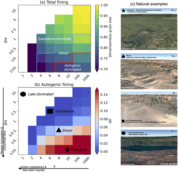
Sediments deposited within river channels form the stratigraphic record, which has been used to interpret tectonic events, basin subsidence, and changes in precipitation long after ancient mountain chains have eroded away. Our work combines methods for estimating gravel fining with a landscape evolution model in order to analyze the grain size preserved within the stratigraphic record with greater complexity (e.g. considering topography and channel dynamics) than past approaches.
Amanda Lily Wild, Jean Braun, Alexander C. Whittaker, Marine Prieur, and Sebastien Castelltort
Earth Surf. Dynam., 13, 889–905, https://doi.org/10.5194/esurf-13-889-2025, https://doi.org/10.5194/esurf-13-889-2025, 2025
Short summary
Short summary
Sediments deposited within river channels form the stratigraphic record, which has been used to interpret tectonic events, basin subsidence, and changes in precipitation long after ancient mountain chains have eroded away. Our work combines methods for estimating gravel fining with a Landscape Evolution Model in order to analyze the grain size preserved within the stratigraphic record with greater complexity (e.g. considering topography and channel dynamics) than past approaches.
Amanda Lily Wild, Jean Braun, Alexander C. Whittaker, and Sebastien Castelltort
Earth Surf. Dynam., 13, 875–887, https://doi.org/10.5194/esurf-13-875-2025, https://doi.org/10.5194/esurf-13-875-2025, 2025
Short summary
Short summary
Sediments deposited within river channels form the stratigraphic record, which has been used to interpret tectonic events, basin subsidence, and changes in precipitation long after ancient mountain chains have eroded away. Our work combines methods for estimating gravel fining with a landscape evolution model in order to analyze the grain size preserved within the stratigraphic record with greater complexity (e.g. considering topography and channel dynamics) than past approaches.
Fritz Schlunegger, Edi Kissling, Dimitri Tibo Bandou, Guilhem Amin Douillet, David Mair, Urs Marti, Regina Reber, Patrick Schläfli, and Michael Alfred Schwenk
Earth Surf. Dynam., 12, 1371–1389, https://doi.org/10.5194/esurf-12-1371-2024, https://doi.org/10.5194/esurf-12-1371-2024, 2024
Short summary
Short summary
Overdeepenings are bedrock depressions filled with sediment. We combine the results of a gravity survey with drilling data to explore the morphology of such a depression beneath the city of Bern. We find that the target overdeepening comprises two basins >200 m deep. They are separated by a bedrock riegel that itself is cut by narrow canyons up to 150 m deep. We postulate that these structures formed underneath a glacier, where erosion by subglacial meltwater caused the formation of the canyons.
Renas I. Koshnaw, Jonas Kley, and Fritz Schlunegger
Solid Earth, 15, 1365–1383, https://doi.org/10.5194/se-15-1365-2024, https://doi.org/10.5194/se-15-1365-2024, 2024
Short summary
Short summary
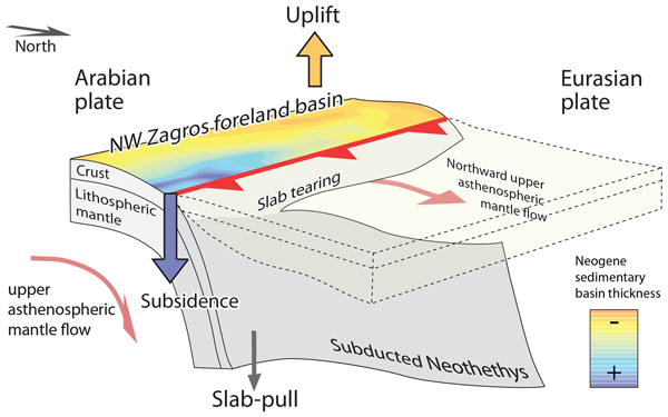
This study investigates how Earth's geodynamic processes shaped the NW Zagros mountain belt in the Middle East. The Neogene foreland basin underwent subsidence due to the load of the surface and the subducting slab and was later influenced by the Neotethys horizontal slab tearing and the associated asthenospheric mantle flow during the Late Miocene and onward.
Hoda Moradi, Gerhard Furrer, Michael Margreth, David Mair, and Christoph Wanner
The Cryosphere, 18, 5153–5171, https://doi.org/10.5194/tc-18-5153-2024, https://doi.org/10.5194/tc-18-5153-2024, 2024
Short summary
Short summary
Detailed monitoring of a rock glacier spring in the Eastern Alps showed that more than 1 tonne of toxic solutes, such as aluminum, nickel, and manganese, is mobilized each year from a small permafrost area. The strong mobilization is caused by rock weathering and long-term accumulation of toxic solutes in permafrost ice. Today, climate-change-induced permafrost degradation leads to a quick and focused export in summer. This forms an unexpected, novel hazard for alpine and high-latitude areas.
Michael Margreth, Florian Lustenberger, Dorothea Hug Peter, Fritz Schlunegger, and Massimiliano Zappa
Nat. Hazards Earth Syst. Sci. Discuss., https://doi.org/10.5194/nhess-2024-78, https://doi.org/10.5194/nhess-2024-78, 2024
Publication in NHESS not foreseen
Short summary
Short summary
Recession models (RM) are crucial for observing the low flow behavior of a catchment. We developed two novel RM, which are designed to represent slowly draining catchment conditions. With a newly designed low flow prediction procedure we tested the prediction capability of these two models and three others from literature. One of our novel products delivered the best results, because it best represents the slowly draining catchment conditions.
Daniel Bolliger, Fritz Schlunegger, and Brian W. McArdell
Nat. Hazards Earth Syst. Sci., 24, 1035–1049, https://doi.org/10.5194/nhess-24-1035-2024, https://doi.org/10.5194/nhess-24-1035-2024, 2024
Short summary
Short summary
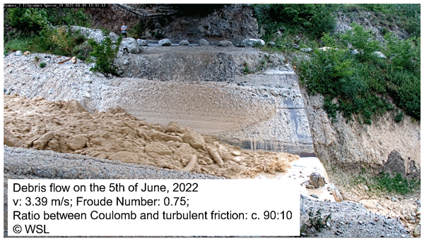
We analysed data from the Illgraben debris flow monitoring station, Switzerland, and we modelled these flows with a debris flow runout model. We found that no correlation exists between the grain size distribution, the mineralogical composition of the matrix, and the debris flow properties. The flow properties rather appear to be determined by the flow volume, from which most other parameters can be derived.
Ariel Henrique do Prado, David Mair, Philippos Garefalakis, Chantal Schmidt, Alexander Whittaker, Sebastien Castelltort, and Fritz Schlunegger
Hydrol. Earth Syst. Sci., 28, 1173–1190, https://doi.org/10.5194/hess-28-1173-2024, https://doi.org/10.5194/hess-28-1173-2024, 2024
Short summary
Short summary
Engineering structures known as check dams are built with the intention of managing streams. The effectiveness of such structures can be expressed by quantifying the reduction of the sediment flux after their implementation. In this contribution, we estimate and compare the volumes of sediment transported in a mountain stream for engineered and non-engineered conditions. We found that without check dams the mean sediment flux would be ca. 10 times larger in comparison with the current situation.
David Mair, Ariel Henrique Do Prado, Philippos Garefalakis, Alessandro Lechmann, Alexander Whittaker, and Fritz Schlunegger
Earth Surf. Dynam., 10, 953–973, https://doi.org/10.5194/esurf-10-953-2022, https://doi.org/10.5194/esurf-10-953-2022, 2022
Short summary
Short summary
Grain size data are important for studying and managing rivers, but they are difficult to obtain in the field. Therefore, methods have been developed that use images from small and remotely piloted aircraft. However, uncertainty in grain size data from such image-based products is understudied. Here we present a new way of uncertainty estimation that includes fully modeled errors. We use this technique to assess the effect of several image acquisition aspects on grain size uncertainty.
Yuri Brugnara, Michael Horn, and Isabella Salvador
Earth Syst. Sci. Data Discuss., https://doi.org/10.5194/essd-2022-290, https://doi.org/10.5194/essd-2022-290, 2022
Manuscript not accepted for further review
Short summary
Short summary
We provide the only known long temperature and pressure instrumental record for the south-eastern Alps covering the first half of the 19th century. It was measured in the town of Rovereto, in the Adige valley, between 1800–1839 by a physics teacher. The data are complemented with measurements from Bolzano/Bozen for 1842–1849 and are converted to modern units and homogenized to account for changes in observation times and exposure of the instruments.
Michael A. Schwenk, Laura Stutenbecker, Patrick Schläfli, Dimitri Bandou, and Fritz Schlunegger
E&G Quaternary Sci. J., 71, 163–190, https://doi.org/10.5194/egqsj-71-163-2022, https://doi.org/10.5194/egqsj-71-163-2022, 2022
Short summary
Short summary
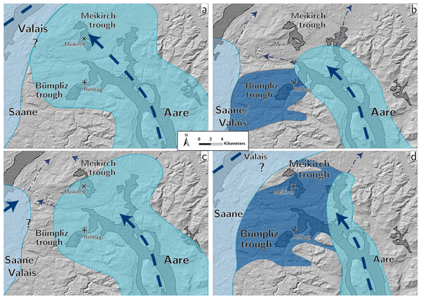
We investigated the origin of glacial sediments in the Bern area to determine their route of transport either with the Aare Glacier or the Valais Glacier. These two ice streams are known to have joined in the Bern area during the last major glaciation (ca. 20 000 years ago). However, little is known about the ice streams prior to this last glaciation. Here we collected evidence that during a glaciation about 250 000 years ago the Aare Glacier dominated the area as documented in the deposits.
Ariel Henrique do Prado, Renato Paes de Almeida, Cristiano Padalino Galeazzi, Victor Sacek, and Fritz Schlunegger
Earth Surf. Dynam., 10, 457–471, https://doi.org/10.5194/esurf-10-457-2022, https://doi.org/10.5194/esurf-10-457-2022, 2022
Short summary
Short summary
Our work is focused on describing how and why the terrace levels of central Amazonia were formed during the last 100 000 years. We propose to address this question through a landscape evolution numerical model. Our results show that terrace levels at lower elevation were established in response to dry–wet climate changes and the older terrace levels at higher elevations most likely formed in response to a previously higher elevation of the regional base level.
Alessandro Lechmann, David Mair, Akitaka Ariga, Tomoko Ariga, Antonio Ereditato, Ryuichi Nishiyama, Ciro Pistillo, Paola Scampoli, Mykhailo Vladymyrov, and Fritz Schlunegger
Geosci. Model Dev., 15, 2441–2473, https://doi.org/10.5194/gmd-15-2441-2022, https://doi.org/10.5194/gmd-15-2441-2022, 2022
Short summary
Short summary
Muon tomography is a technology that is used often in geoscientific research. The know-how of data analysis is, however, still possessed by physicists who developed this technology. This article aims at providing geoscientists with the necessary tools to perform their own analyses. We hope that a lower threshold to enter the field of muon tomography will allow more geoscientists to engage with muon tomography. SMAUG is set up in a modular way to allow for its own modules to work in between.
Heye Reemt Bogena, Martin Schrön, Jannis Jakobi, Patrizia Ney, Steffen Zacharias, Mie Andreasen, Roland Baatz, David Boorman, Mustafa Berk Duygu, Miguel Angel Eguibar-Galán, Benjamin Fersch, Till Franke, Josie Geris, María González Sanchis, Yann Kerr, Tobias Korf, Zalalem Mengistu, Arnaud Mialon, Paolo Nasta, Jerzy Nitychoruk, Vassilios Pisinaras, Daniel Rasche, Rafael Rosolem, Hami Said, Paul Schattan, Marek Zreda, Stefan Achleitner, Eduardo Albentosa-Hernández, Zuhal Akyürek, Theresa Blume, Antonio del Campo, Davide Canone, Katya Dimitrova-Petrova, John G. Evans, Stefano Ferraris, Félix Frances, Davide Gisolo, Andreas Güntner, Frank Herrmann, Joost Iwema, Karsten H. Jensen, Harald Kunstmann, Antonio Lidón, Majken Caroline Looms, Sascha Oswald, Andreas Panagopoulos, Amol Patil, Daniel Power, Corinna Rebmann, Nunzio Romano, Lena Scheiffele, Sonia Seneviratne, Georg Weltin, and Harry Vereecken
Earth Syst. Sci. Data, 14, 1125–1151, https://doi.org/10.5194/essd-14-1125-2022, https://doi.org/10.5194/essd-14-1125-2022, 2022
Short summary
Short summary
Monitoring of increasingly frequent droughts is a prerequisite for climate adaptation strategies. This data paper presents long-term soil moisture measurements recorded by 66 cosmic-ray neutron sensors (CRNS) operated by 24 institutions and distributed across major climate zones in Europe. Data processing followed harmonized protocols and state-of-the-art methods to generate consistent and comparable soil moisture products and to facilitate continental-scale analysis of hydrological extremes.
Michael A. Schwenk, Patrick Schläfli, Dimitri Bandou, Natacha Gribenski, Guilhem A. Douillet, and Fritz Schlunegger
Sci. Dril., 30, 17–42, https://doi.org/10.5194/sd-30-17-2022, https://doi.org/10.5194/sd-30-17-2022, 2022
Short summary
Short summary
A scientific drilling was conducted into a bedrock trough (overdeepening) in Bern-Bümpliz (Switzerland) in an effort to advance the knowledge of the Quaternary prior to 150 000 years ago. We encountered a 208.5 m-thick succession of loose sediments (gravel, sand and mud) in the retrieved core and identified two major sedimentary sequences (A: lower, B: upper). The sedimentary suite records two glacial advances and the subsequent filling of a lake sometime between 300 000 and 200 000 years ago.
Emilija Krsnik, Katharina Methner, Marion Campani, Svetlana Botsyun, Sebastian G. Mutz, Todd A. Ehlers, Oliver Kempf, Jens Fiebig, Fritz Schlunegger, and Andreas Mulch
Solid Earth, 12, 2615–2631, https://doi.org/10.5194/se-12-2615-2021, https://doi.org/10.5194/se-12-2615-2021, 2021
Short summary
Short summary
Here we present new surface elevation constraints for the middle Miocene Central Alps based on stable and clumped isotope geochemical analyses. Our reconstructed paleoelevation estimate is supported by isotope-enabled paleoclimate simulations and indicates that the Miocene Central Alps were characterized by a heterogeneous and spatially transient topography with high elevations locally exceeding 4000 m.
Renas I. Koshnaw, Fritz Schlunegger, and Daniel F. Stockli
Solid Earth, 12, 2479–2501, https://doi.org/10.5194/se-12-2479-2021, https://doi.org/10.5194/se-12-2479-2021, 2021
Short summary
Short summary
As continental plates collide, mountain belts grow. This study investigated the provenance of rocks from the northwestern segment of the Zagros mountain belt to unravel the convergence history of the Arabian and Eurasian plates. Provenance data synthesis and field relationships suggest that the Zagros Mountains developed as a result of the oceanic crust emplacement on the Arabian continental plate, followed by the Arabia–Eurasia collision and later uplift of the broader region.
Cited articles
Allen, P. A., Michael, N. A., D'Arcy, M., Roda-Boluda, D. C., Whittaker, A. C., Duller, R. A., and Armitage, J. J.: Fractionation of grain size in terrestrial sediment routing systems, Basin Res., 29, 180–202, https://doi.org/10.1111/bre.12172, 2017.
Archit, A., Freckmann, L., Nair, S., Khalid, N., Hilt, P., Rajashekar, V., Freitag, M., Teuber, C., Buckley, G., von Haaren, S., Gupta, S., Dengel, A., Ahmed, S., and Pape, C.: Segment Anything for Microscopy, Nat. Methods, 22, 579–591, https://doi.org/10.1038/s41592-024-02580-4, 2025.
Arzt, M., Deschamps, J., Schmied, C., Pietzsch, T., Schmidt, D., Tomancak, P., Haase, R., and Jug, F.: LABKIT: Labeling and Segmentation Toolkit for Big Image Data, Front. Comput. Sci., 4, https://doi.org/10.3389/fcomp.2022.777728, 2022.
Attal, M. and Lavé, J.: Pebble abrasion during fluvial transport: Experimental results and implications for the evolution of the sediment load along rivers, J. Geophys. Res.-Earth, 114, https://doi.org/10.1029/2009JF001328, 2009.
Azad, R., Aghdam, E. K., Rauland, A., Jia, Y., Avval, A. H., Bozorgpour, A., Karimijafarbigloo, S., Cohen, J. P., Adeli, E., and Merhof, D.: Medical Image Segmentation Review: The Success of U-Net, IEEE T. Pattern Anal., 46, 10076–10095, https://doi.org/10.1109/TPAMI.2024.3435571, 2024.
Azzam, F., Blaise, T., and Brigaud, B.: Automated petrographic image analysis by supervised and unsupervised machine learning methods, Sedimentologika, 2, https://doi.org/10.57035/journals/sdk.2024.e22.1594, 2024.
Back, A. L., Kana Tepakbong, C., Bédard, L. P., and Barry, A.: From rocks to pixels: a comprehensive framework for grain shape characterization through image analysis of roundness and roughness descriptors, Front. Earth Sci., 13, https://doi.org/10.3389/feart.2025.1634237, 2025a.
Back, A. L., Kana Tepakbong, C., Bédard, L. P., and Barry, A.: From rocks to pixels: a comprehensive framework for grain shape characterization through the image analysis of size, orientation, and form descriptors, Front. Earth Sci., 13, https://doi.org/10.3389/feart.2025.1508690, 2025b.
Baptista, P., Cunha, T. R., Gama, C., and Bernardes, C.: A new and practical method to obtain grain size measurements in sandy shores based on digital image acquisition and processing, Sediment. Geol., 282, 294–306, https://doi.org/10.1016/j.sedgeo.2012.10.005, 2012.
Baynes, E. R. C., Lague, D., Steer, P., Bonnet, S., and Illien, L.: Sediment flux-driven channel geometry adjustment of bedrock and mixed gravel–bedrock rivers, Earth Surf. Proc. Land., 45, 3714–3731, https://doi.org/10.1002/esp.4996, 2020.
Benet, D., Costa, F., Widiwijayanti, C., Pallister, J., Pedreros, G., Allard, P., Humaida, H., Aoki, Y., and Maeno, F.: VolcAshDB: a Volcanic Ash DataBase of classified particle images and features, B. Volcanol., 86, https://doi.org/10.1007/s00445-023-01695-4, 2024.
Bertin, S. and Friedrich, H.: Field application of close-range digital photogrammetry (CRDP) for grain-scale fluvial morphology studies, Earth Surf. Proc. Land., 41, 1358–1369, https://doi.org/10.1002/esp.3906, 2016.
Biguenet, M., Sabatier, P., Chaumillon, E., Chagué, C., Arnaud, F., Jorissen, F., Coulombier, T., Geba, E., Cordrie, L., Vacher, P., Develle, A. L., Chalmin, E., Soufi, F., and Feuillet, N.: A 1600 year-long sedimentary record of tsunamis and hurricanes in the Lesser Antilles (Scrub Island, Anguilla), Sediment. Geol., 412, https://doi.org/10.1016/j.sedgeo.2020.105806, 2021.
Bouza, L., Bugeau, A., and Lannelongue, L.: How to estimate carbon footprint when training deep learning models? A guide and review, Environ. Res. Commun., 11, https://doi.org/10.1088/2515-7620/acf81b, 2023.
Braylan, A., Alonso, O., and Lease, M.: Measuring Annotator Agreement Generally across Complex Structured, Multi-object, and Free-text Annotation Tasks, in: WWW 2022 – Proceedings of the ACM Web Conference 2022, 1720–1730, https://doi.org/10.1145/3485447.3512242, 2022.
Brayshaw, D. D.: Bankfull and effective discharge in small mountain streams of British Columbia, PhD thesis University of British Columbia, https://doi.org/10.14288/1.0072555, 2012.
Brodu, N. and Lague, D.: 3D terrestrial lidar data classification of complex natural scenes using a multi-scale dimensionality criterion: Applications in geomorphology, ISPRS J. Photogramm., 68, 121–134, https://doi.org/10.1016/j.isprsjprs.2012.01.006, 2012.
Brown, T. B., Mann, B., Ryder, N., Subbiah, M., Kaplan, J., Dhariwal, P., Neelakantan, A., Shyam, P., Sastry, G., Askell, A., Agarwal, S., Herbert-Voss, A., Krueger, G., Henighan, T., Child, R., Ramesh, A., Ziegler, D. M., Wu, J., Winter, C., Hesse, C., Chen, M., Sigler, E., Litwin, M., Gray, S., Chess, B., Clark, J., Berner, C., McCandlish, S., Radford, A., Sutskever, I., and Amodei, D.: Language Models are Few-Shot Learners, arXiv [preprint], arXiv:2005.14165, 22 July 2020, 2020.
Bunte, K. and Abt, S. R.: Sampling Surface and Subsurface Particle-Size Distributions in Wadable Gravel-and Cobble-Bed Streams for Analyses in Sediment Transport, Hydraulics, and Streambed Monitoring, US Department of Agriculture, Forest Service, Rocky Mountain Research Station, https://doi.org/10.2737/RMRS-GTR-74, 2001.
Buscombe, D.: Transferable wavelet method for grain-size distribution from images of sediment surfaces and thin sections, and other natural granular patterns, Sedimentology, 60, 1709–1732, https://doi.org/10.1111/sed.12049, 2013.
Buscombe, D.: SediNet: a configurable deep learning model for mixed qualitative and quantitative optical granulometry, Earth Surf. Proc. Land., 45, 638–651, https://doi.org/10.1002/esp.4760, 2020.
Butler, J. B., Lane, S. N., and Chandler, J. H.: Automated extraction of grain-size data from gravel surfaces using digital image processing, J. Hydraul. Res., 39, 519–529, https://doi.org/10.1080/00221686.2001.9628276, 2001.
Carbonneau, P. E., Lane, S. N., and Bergeron, N. E.: Catchment-scale mapping of surface grain size in gravel bed rivers using airborne digital imagery, Water Resour. Res., 40, https://doi.org/10.1029/2003WR002759, 2004.
Chan, V., Rheinwalt, A., and Bookhagen, B.: OrthoSAM: multi-scale extension of the Segment Anything Model for river pebble delineation from large orthophotos, Earth Surf. Dynam., 14, 391–416, https://doi.org/10.5194/esurf-14-391-2026, 2026.
Chardon, V., Piasny, G., and Schmitt, L.: Comparison of software accuracy to estimate the bed grain size distribution from digital images: A test performed along the Rhine River, River Res. Appl., 38, 358–367, https://doi.org/10.1002/rra.3910, 2022.
Chen, X., Hassan, M. A., and Fu, X.: Convolutional neural networks for image-based sediment detection applied to a large terrestrial and airborne dataset, Earth Surf. Dynam., 10, 349–366, https://doi.org/10.5194/esurf-10-349-2022, 2022.
Chen, Y., Bao, J., Chen, R., Li, B., Yang, Y., Renteria, L., Delgado, D., Forbes, B., Goldman, A. E., Simhan, M., Barnes, M. E., Laan, M., McKever, S., Hou, Z. J., Chen, X., Scheibe, T., and Stegen, J.: Quantifying Streambed Grain Size, Uncertainty, and Hydrobiogeochemical Parameters Using Machine Learning Model YOLO, Water Resour. Res., 60, https://doi.org/10.1029/2023WR036456, 2024.
Chen, Z., Scott, C., Keating, D., Clarke, A., Das, J., and Arrowsmith, R.: Quantifying and analysing rock trait distributions of rocky fault scarps using deep learning, Earth Surf. Proc. Land., 48, 1234–1250, https://doi.org/10.1002/esp.5545, 2023.
Cox, M. R. and Budhu, M.: A practical approach to grain shape quantification, Eng. Geol., 96, 1–16, https://doi.org/10.1016/j.enggeo.2007.05.005, 2008.
Cnudde, V. and Boone, M. N.: High-resolution X-ray computed tomography in geosciences: A review of the current technology and applications, Earth. Sci. Rev., 123, 1–17, https://doi.org/10.1016/j.earscirev.2013.04.003, 2013.
Daniels, M. D. and McCusker, M. H.: Operator bias characterizing stream substrates using Wolman pebble counts with a standard measurement template, Geomorphology, 115, 194–198, https://doi.org/10.1016/j.geomorph.2009.09.038, 2010.
Dawson, M., Dawson, H., Gurnell, A., Lewin, J., and Macklin, M. G.: AI‐assisted interpretation of changes in riparian woodland from archival aerial imagery using Meta’s segment anything model, Earth Surf. Process. Landf., 50, https://doi.org/10.1002/esp.6053, 2025.
Deal, E., Venditti, J. G., Benavides, S. J., Bradley, R., Zhang, Q., Kamrin, K., and Perron, J. T.: Grain shape effects in bed load sediment transport, Nature, 613, 298–302, https://doi.org/10.1038/s41586-022-05564-6, 2023.
Detert, M. and Weitbrecht, V.: Automatic object detection to analyze the geometry of gravel grains – a free stand-alone tool, in: River Flow 2012, edited by: Murillo, R. M., Taylor & Francis Group, London, 595–600, ISBN 978-0-415-62129-8, 2012.
DiBiase, R. A., Lamb, M. P., Ganti, V., and Booth, A. M.: Slope, grain size, and roughness controls on dry sediment transport and storage on steep hillslopes, J. Geophys. Res.-Earth, 122, 941–960, https://doi.org/10.1002/2016JF003970, 2017.
Dietrich, W. E., Kirchner, J. W., Ikeda, H., and Iseya, F.: Sediment supply and the development of the coarse surface layer in gravel-bedded rivers, Nature, 340, 215-217, 1989.
Domokos, G., Jerolmack, D. J., Sipos, A. Á., and Török, Á.: How river rocks round: Resolving the shape-size paradox, PLOS ONE, 9, https://doi.org/10.1371/journal.pone.0088657, 2014.
Dosovitskiy, A., Beyer, L., Kolesnikov, A., Weissenborn, D., Zhai, X., Unterthiner, T., Dehghani, M., Minderer, M., Heigold, G., Gelly, S., Uszkoreit, J., and Houlsby, N.: An Image is Worth 16 × 16 Words: Transformers for Image Recognition at Scale, arXiv [preprint], arXiv:2010.11929, 3 June 2021, 2021.
Dunne, K. B. J. and Jerolmack, D. J.: Evidence of, and a proposed explanation for, bimodal transport states in alluvial rivers, Earth Surf. Dynam., 6, 583–594, https://doi.org/10.5194/esurf-6-583-2018, 2018.
Eaton, B. C., Moore, R. D., and MacKenzie, L. G.: Percentile-based grain size distribution analysis tools (GSDtools) – estimating confidence limits and hypothesis tests for comparing two samples, Earth Surf. Dynam., 7, 789–806, https://doi.org/10.5194/esurf-7-789-2019, 2019.
Eltner, A., Kaiser, A., Castillo, C., Rock, G., Neugirg, F., and Abellán, A.: Image-based surface reconstruction in geomorphometry – merits, limits and developments, Earth Surf. Dynam., 4, 359–389, https://doi.org/10.5194/esurf-4-359-2016, 2016.
Everingham, M., Eslami, S. M. A., Van Gool, L., Williams, C. K. I., Winn, J., and Zisserman, A.: The Pascal Visual Object Classes Challenge: A Retrospective, Int. J. Comput. Vis., 111, 98–136, https://doi.org/10.1007/s11263-014-0733-5, 2015.
Fabbri, S. C., Sabatier, P., Paris, R., Falvard, S., Feuillet, N., Lothoz, A., St-Onge, G., Gailler, A., Cordrie, L., Arnaud, F., Biguenet, M., Coulombier, T., Mitra, S., and Chaumillon, E.: Deciphering the sedimentary imprint of tsunamis and storms in the Lesser Antilles (Saint Martin): A 3500-year record in a coastal lagoon, Mar. Geol., 471, https://doi.org/10.1016/j.margeo.2024.107284, 2024.
Fehr, R.: Einfache Bestimmung der Korngrössenverteilung von Geschiebematerial mit Hilfe der Linienzahlanalyse [Simple detection of grain size distribution of sediment material using line-count analysis], Schweizer Ingenieur und Architekt, 105, 1104–1109, 1987 (in German).
Fort, S., Ren, J., and Lakshminarayanan, B.: Exploring the Limits of Out-of-Distribution Detection, arXiv [preprint], arXiv:2106.03004, 29 July 2021, https://doi.org/10.48550/arXiv.2106.03004, 2021.
Garefalakis, P., do Prado, A. H., Mair, D., Douillet, G. A., Nyffenegger, F., and Schlunegger, F.: Comparison of three grain size measuring methods applied to coarse-grained gravel deposits, Sediment Geol., 446, https://doi.org/10.1016/j.sedgeo.2023.106340, 2023.
Garefalakis, P., do Prado, A. H., Whittaker, A. C., Mair, D., and Schlunegger, F.: Quantification of sediment fluxes and intermittencies from Oligo–Miocene megafan deposits in the Swiss Molasse basin, Basin Res., 36, https://doi.org/10.1111/bre.12865, 2024.
Gatys, L. A., Ecker, A. S., and Bethge, M.: Image Style Transfer Using Convolutional Neural Networks, in: Proceedings of the IEEE Computer Society Conference on Computer Vision and Pattern Recognition, 2414–2423, https://doi.org/10.1109/CVPR.2016.265, 2016.
Guerit, L., Barrier, L., Narteau, C., Métivier, F., Liu, Y., Lajeunesse, E., Gayer, E., Meunier, P., Malverti, L., and Ye, B.: The Grain-size Patchiness of Braided Gravel-Bed Streams – example of the Urumqi River (northeast Tian Shan, China), Adv. Geosci., 37, 27–39, https://doi.org/10.5194/adgeo-37-27-2014, 2014.
Guerit, L., Barrier, L., Liu, Y., Narteau, C., Lajeunesse, E., Gayer, E., and Métivier, F.: Uniform grain-size distribution in the active layer of a shallow, gravel-bedded, braided river (the Urumqi River, China) and implications for paleo-hydrology, Earth Surf. Dynam., 6, 1011–1021, https://doi.org/10.5194/esurf-6-1011-2018, 2018.
He, K., Gkioxari, G., Dollár, P., and Girshick, R.: Mask R-CNN, arXiv [preprint], arXiv:1703.06870, 2017.
Hendrycks, D., Liu, X., Wallace, E., Dziedzic, A., Krishnan, R., and Song, D.: Pretrained Transformers Improve Out-of-Distribution Robustness, arXiv [preprint], arXiv:2004.06100, 13 April, 2020.
Hiller, C., Leistner, S., Helfricht, K., and Achleitner, S.: Robust estimations of areal grain size distribution from geometric surface roughness in a proglacial outwash area, Geomorphology, 439, https://doi.org/10.1016/j.geomorph.2023.108857, 2023.
Houston, A. N., Schmidt, S., Tarquis, A. M., Otten, W., Baveye, P. C., and Hapca, S. M.: Effect of scanning and image reconstruction settings in X-ray computed microtomography on quality and segmentation of 3D soil images, Geoderma, 207–208, 154–165, https://doi.org/10.1016/j.geoderma.2013.05.017, 2013.
Hsiang, A. Y., Brombacher, A., Rillo, M. C., Mleneck‐Vautravers, M. J., Conn, S., Lordsmith, S., Jentzen, A., Henehan, M. J., Metcalfe, B., Fenton, I. S., Wade, B. S., Fox, L., Meilland, J., Davis, C. V., Baranowski, U., Groeneveld, J., Edgar, K. M., Movellan, A., Aze, T., Dowsett, H. J., Miller, C. G., Rios, N., and Hull, P. M.: Endless Forams: >34 000 Modern Planktonic Foraminiferal Images for Taxonomic Training and Automated Species Recognition Using Convolutional Neural Networks, Paleoceanogr. Paleoclimatol., 34, 1157–1177, https://doi.org/10.1029/2019PA003612, 2019.
Ibbeken, H. and Schleyer, R.: Photo-sieving: A method for grain-size analysis of coarse-grained, unconsolidated bedding surfaces, Earth Surf. Proc. Land., 11, 59–77, https://doi.org/10.1002/esp.3290110108, 1986.
Israel, U., Marks, M., Dilip, R., Li, Q., Yu, C., Laubscher, E., Iqbal, A., Pradhan, E., Ates, A., Abt, M., Brown, C., Pao, E., Li, S., Pearson-Goulart, A., Perona, P., Gkioxari, G., Barnowski, R., Yue, Y., and Van Valen, D.: CellSAM: A Foundation Model for Cell Segmentation, bioRxiv [preprint], https://doi.org/10.1101/2023.11.17.567630, 20 November 2023.
Israel, U., Marks, M., Dilip, R., Li, Q., Yu, C., Laubscher, E., Iqbal, A., Pradhan, E., Ates, A., Abt, M., Brown, C., Pao, E., Li, S., Pearson-Goulart, A., Perona, P., Gkioxari, G., Barnowski, R., Yue, Y., and Van Valen, D.: CellSAM: A Foundation Model for Cell Segmentation, bioRxiv [preprint], https://doi.org/10.1101/2023.11.17.567630, 20 November 2025.
Israeli, Y. and Emmanuel, S.: Impact of grain size and rock composition on simulated rock weathering, Earth Surf. Dynam., 6, 319–327, https://doi.org/10.5194/esurf-6-319-2018, 2018.
Jay, M., Ostapenco, V., Lefevre, L., Trystram, D., Orgerie, A.-C., and Fichel, B.: An experimental comparison of software-based power meters: focus on CPU and GPU, in: 2023 IEEE/ACM 23rd International Symposium on Cluster, Cloud and Internet Computing (CCGrid), 106–118, https://doi.org/10.1109/CCGrid57682.2023.00020, 2023.
Kettler, C., Phillips, E., Pichler, K., Smrzka, D., Vandyk, T. M., and Le Heron, D. P.: 3D macro- and microfabric analyses of Neoproterozoic diamictites from the Valjean Hills, California (United States), Front. Earth Sci., 11, https://doi.org/10.3389/feart.2023.929011, 2023.
Kirillov, A., Mintun, E., Ravi, N., Mao, H., Rolland, C., Gustafson, L., Xiao, T., Whitehead, S., Berg, A. C., Lo, W.-Y., Dollár, P., and Girshick, R.: Segment Anything, arXiv [preprint], arXiv:2304.02643, 2023.
Kloster, M., Burfeid-Castellanos, A. M., Langenkämper, D., Nattkemper, T. W., and Beszteri, B.: Improving deep learning-based segmentation of diatoms in gigapixel-sized virtual slides by object-based tile positioning and object integrity constraint, PLoS One, 18, e0272103, https://doi.org/10.1371/journal.pone.0272103, 2023.
Lacoste, A., Luccioni, A., Schmidt, V., and Dandres, T.: Quantifying the Carbon Emissions of Machine Learning, arXiv [preprint], arXiv:1910.09700, https://doi.org/10.48550/arXiv.1910.09700, 2019.
Lang, N., Irniger, A., Rozniak, A., Hunziker, R., Wegner, J. D., and Schindler, K.: GRAINet: mapping grain size distributions in river beds from UAV images with convolutional neural networks, Hydrol. Earth Syst. Sci., 25, 2567–2597, https://doi.org/10.5194/hess-25-2567-2021, 2021.
Lepp, A. P., Miller, L. E., Anderson, J. B., O'Regan, M., Winsborrow, M. C. M., Smith, J. A., Hillenbrand, C.-D., Wellner, J. S., Prothro, L. O., and Podolskiy, E. A.: Insights into glacial processes from micromorphology of silt-sized sediment, The Cryosphere, 18, 2297–2319, https://doi.org/10.5194/tc-18-2297-2024, 2024.
Li, Y., Mao, H., Girshick, R., and He, K.: Exploring Plain Vision Transformer Backbones for Object Detection, arXiv [preprint], arXiv:2203.16527, 2022.
Litty, C. and Schlunegger, F.: Controls on pebbles' size and shape in streams of the Swiss alps, J. Geol., 125, 101–112, https://doi.org/10.1086/689183, 2017.
Liu, T., Liu, Z., Zhang, K., Li, C., Zhang, Y., Mu, Z., Mu, M., Xu, M., Zhang, Y., and Li, X.: Research on the generation and annotation method of thin section images of tight oil reservoir based on deep learning, Sci. Rep., 14, https://doi.org/10.1038/s41598-024-63430-z, 2024.
Loshchilov, I. and Hutter, F.: Decoupled Weight Decay Regularization, arXiv [preprint], arXiv:1711.05101, 2019.
Mair, D.: Dataset and model weights for ImageGrains (Version v1), Zenodo, https://doi.org/10.5281/zenodo.8005771, 2023.
Mair, D., Do Prado, A. H., Garefalakis, P., Lechmann, A., Whittaker, A., and Schlunegger, F.: Grain size of fluvial gravel bars from close-range UAV imagery – uncertainty in segmentation-based data, Earth Surf. Dynam., 10, 953–973, https://doi.org/10.5194/esurf-10-953-2022, 2022.
Mair, D., Witz, G., Do Prado, A. H., Garefalakis, P., and Schlunegger, F.: Automated detecting, segmenting and measuring of grains in images of fluvial sediments: The potential for large and precise data from specialist deep learning models and transfer learning, Earth Surf. Proc. Land., 49, 1099–1116, https://doi.org/10.1002/esp.5755, 2024.
Mair, D., do Prado, A., Garefalakis, P., Wild, A. L., Ville, F., Schuster, B., Österle, J., Fabbri, S. C., Litty, C., Achleitner, S., Leistner, S., Hiller, C., and Schlunegger, F.: ImageGrains 2.0 dataset (Version v2), Zenodo [data set], https://doi.org/10.5281/zenodo.17866827, 2025a.
Mair, D., Witz, G., do Prado, A., Garefalakis, P., Wild, A. L., Ville, F., Schuster, B., Horn, M., Österle, J., Fabbri, S. C., Litty, C., Achleitner, S., Leistner, S., Hiller, C., and Schlunegger, F.: ImageGrains 2.0 models, Zenodo [data set], https://doi.org/10.5281/zenodo.15309323, 2025b.
Mair, D., Witz, G., and corolarry: dmair1989/imagegrains: v2.0.2 (v2.0.2), Zenodo [software], https://doi.org/10.5281/zenodo.21236405, 2026.
Marc, O., Turowski, J. M., and Meunier, P.: Controls on the grain size distribution of landslides in Taiwan: the influence of drop height, scar depth and bedrock strength, Earth Surf. Dynam., 9, 995–1011, https://doi.org/10.5194/esurf-9-995-2021, 2021.
Marchetti, G., Bizzi, S., Belletti, B., Lastoria, B., Comiti, F., and Carbonneau, P. E.: Mapping riverbed sediment size from Sentinel-2 satellite data, Earth Surf. Proc. Land., 47, 2544–2559, https://doi.org/10.1002/esp.5394, 2022.
Miazza, R., Pascal, I., and Ancey, C.: Automated grain sizing from uncrewed aerial vehicles imagery of a gravel-bed river: Benchmarking of three object-based methods, Earth Surf. Proc. Land., 49, 1503–1514, https://doi.org/10.1002/esp.5782, 2024.
Miller, K. L., Szabó, T., Jerolmack, D. J., and Domokos, G.: Quantifying the significance of abrasion and selective transport for downstream fluvial grain size evolution, J. Geophys. Res.-Earth, 119, 2412–2429, https://doi.org/10.1002/2014JF003156, 2014.
Minaee, S., Boykov, Y., Porikli, F., Plaza, A., Kehtarnavaz, N., and Terzopoulos, D.: Image Segmentation Using Deep Learning: A Survey, IEEE T. Pattern Anal., 44, 3523–3542, https://doi.org/10.1109/TPAMI.2021.3059968, 2022.
Mitra, S., Paris, R., Bernard, L., Abbal, R., Charrier, P., Falvard, S., Costa, P., and Andrade, C.: X-ray tomography applied to tsunami deposits: Optimized image processing and quantitative analysis of particle size, particle shape, and sedimentary fabric in 3D, Mar. Geol., 470, https://doi.org/10.1016/j.margeo.2024.107247, 2024.
Mörtl, C., Baratier, A., Berthet, J., Duvillard, P. A., and De Cesare, G.: GALET: A deep learning image segmentation model for drone based grain size analysis of gravel bars, in: Proceedings of the IAHR World Congress, 5326–5335, https://doi.org/10.3850/IAHR-39WC252171192022895, 2022.
Na, S., Guo, Y., Jiang, F., Ma, H., Gao, J., and Huang, J.: Segment Any Cell: A SAM-Based Auto-Prompting Fine-Tuning Framework for Nuclei Segmentation, IEEE T. Neur. Net Lear., 1–10, https://doi.org/10.1109/TNNLS.2025.3611322, 2025.
Novák-Szabó, T., Sipos, A. Á., Shaw, S., Bertoni, D., Pozzebon, A., Grottoli, E., Sarti, G., Ciavola, P., Domokos, G., and Jerolmack, D. J.: Universal characteristics of particle shape evolution by bed-load chipping, Sci. Adv., 4, https://doi.org/10.1126/sciadv.aao4946, 2018.
Pachitariu, M. and Stringer, C.: Cellpose 2.0: how to train your own model, Nat. Methods, 19, 1634–1641, https://doi.org/10.1038/s41592-022-01663-4, 2022.
Pachitariu, M., Rariden, M., and Stringer, C.: Cellpose-SAM: superhuman generalization for cellular segmentation, bioRxiv [preprint],, https://doi.org/10.1101/2025.04.28.651001, 1 May 2025.
Padilla, R., Netto, S. L., and da Silva, E. A. B.: A Survey on Performance Metrics for Object-Detection Algorithms, in: 2020 International Conference on Systems, Signals and Image Processing (IWSSIP), 237–242, https://doi.org/10.1109/IWSSIP48289.2020.9145130, 2020.
Patel, N. K., Schlunegger, F., Mair, D., Pati, P., do Prado, A. H., Garefalakis, P., and Choudhury, R. K.: Source-to-sink patterns of grain size along the Yamuna River in the Indian Himalaya, Geomorphology, 486, 109909, https://doi.org/10.1016/j.geomorph.2025.109909, 2025.
Patterson, D., Gonzalez, J., Le, Q., Liang, C., Munguia, L.-M., Rothchild, D., So, D., Texier, M., and Dean, J.: Carbon Emissions and Large Neural Network Training, arXiv [preprint], arXiv:2104.10350, https://doi.org/10.48550/arXiv.2104.10350, 2021.
Pfeiffer, A. M., Finnegan, N. J., and Willenbring, J. K.: Sediment supply controls equilibrium channel geometry in gravel rivers, P. Natl. Acad. Sci. USA, 114, 3346–3351, https://doi.org/10.1073/pnas.1612907114, 2017.
Piégay, H., Arnaud, F., Belletti, B., Bertrand, M., Bizzi, S., Carbonneau, P., Dufour, S., Liébault, F., Ruiz-Villanueva, V., and Slater, L.: Remotely sensed rivers in the Anthropocene: state of the art and prospects, Earth Surf. Proc. Land., 45, 157–188, https://doi.org/10.1002/esp.4787, 2020.
Pokhrel, P., Attal, M., Sinclair, H. D., Mudd, S. M., and Naylor, M.: Downstream rounding rate of pebbles in the Himalaya, Earth Surf. Dynam., 12, 515–536, https://doi.org/10.5194/esurf-12-515-2024, 2024.
Preusser, F., Büschelberger, M., Kemna, H. A., Miocic, J., Mueller, D., and May, J. H.: Exploring possible links between Quaternary aggradation in the Upper Rhine Graben and the glaciation history of northern Switzerland, Int. J. Earth Sci., 110, 1827–1846, https://doi.org/10.1007/s00531-021-02043-7, 2021.
Prieur, N. C., Amaro, B., Gonzalez, E., Kerner, H., Medvedev, S., Rubanenko, L., Werner, S. C., Xiao, Z., Zastrozhnov, D., and Lapôtre, M. G. A.: Automatic Characterization of Boulders on Planetary Surfaces From High-Resolution Satellite Images, J. Geophys. Res.-Planets, 128, https://doi.org/10.1029/2023JE008013, 2023.
Purinton, B. and Bookhagen, B.: Introducing PebbleCounts: a grain-sizing tool for photo surveys of dynamic gravel-bed rivers, Earth Surf. Dynam., 7, 859–877, https://doi.org/10.5194/esurf-7-859-2019, 2019.
Purinton, B. and Bookhagen, B.: Tracking Downstream Variability in Large Grain‐Size Distributions in the South‐Central Andes, J. Geophys. Res.-Earth Surf., 126, https://doi.org/10.1029/2021JF006260, 2021.
Quick, L., Sinclair, H. D., Attal, M., and Singh, V.: Conglomerate recycling in the Himalayan foreland basin: Implications for grain size and provenance, GSA Bulletin, 132, 1639–1656, https://doi.org/10.1130/B35334.1, 2020.
Ravi, N., Gabeur, V., Hu, Y.-T., Hu, R., Ryali, C., Ma, T., Khedr, H., Rädle, R., Rolland, C., Gustafson, L., Mintun, E., Pan, J., Alwala, K. V., Carion, N., Wu, C.-Y., Girshick, R., Dollár, P., and Feichtenhofer, C.: SAM 2: Segment Anything in Images and Videos, arXiv [preprint], arXiv:2408.00714, 2024.
Redmon, J., Divvala, S., Girshick, R., and Farhadi, A.: You Only Look Once: Unified, Real-Time Object Detection, arXiv [preprint], arXiv:1506.02640, 2016.
Rezwan, N., Mair, D., Whittaker, A. C., Schlunegger, F., do Prado, A. H., and Setu, S. H.: Assessing Flood-Influenced Sediment Dynamics Using UAV Photogrammetry and Machine Learning: Insights from River Sense, Switzerland, EGUsphere [preprint], https://doi.org/10.5194/egusphere-2025-5145, 2025.
Rheinwalt, A., Purinton, B., and Bookhagen, B.: Curvature-based pebble segmentation for reconstructed surface meshes, Earth Surf. Dynam., 13, 923–940, https://doi.org/10.5194/esurf-13-923-2025, 2025.
Rice, S. and Church, M.: Grain size along two gravel-bed rivers: Statistical variation, spatial pattern and sedimentary links, Earth Surf. Proc. Land., 23, 345–363, https://doi.org/10.1002/(SICI)1096-9837(199804)23:4<345::AID-ESP850>3.0.CO;2-B, 1998.
Rickenmann, D. and Recking, A.: Evaluation of flow resistance in gravel-bed rivers through a large field data set, Water Resour. Res., 47, https://doi.org/10.1029/2010WR009793, 2011.
Ronneberger, O., Fischer, P., and Brox, T.: U-Net: Convolutional Networks for Biomedical Image Segmentation, arXiv [preprint], arXiv:1505.04597, https://doi.org/10.48550/arXiv.1505.04597, 2015.
Saddi, K. C., van Emmerik, T. H. M., Miglino, D., Poggi, M., Isgrò, F., Tasseron, P. F., Daniele, L., and Manfreda, S.: Exploring the Transferability of Image-Based Algorithms for River Plastic Detection: The Value of Small Mixed Data Sets, Water Resour. Res., 62, https://doi.org/10.1029/2025WR040605, 2026.
Schindelin, J., Arganda-Carreras, I., Frise, E., Kaynig, V., Longair, M., Pietzsch, T., Preibisch, S., Rueden, C., Saalfeld, S., Schmid, B., Tinevez, J. Y., White, D. J., Hartenstein, V., Eliceiri, K., Tomancak, P., and Cardona, A.: Fiji: An open-source platform for biological-image analysis, Nat. Methods, 9, 676–682, https://doi.org/10.1038/nmeth.2019, July 2012.
Schlunegger, F. and Garefalakis, P.: Clast imbrication in coarse-grained mountain streams and stratigraphic archives as indicator of deposition in upper flow regime conditions, Earth Surf. Dynam., 6, 743–761, https://doi.org/10.5194/esurf-6-743-2018, 2018.
Schlunegger, F., Delunel, R., and Garefalakis, P.: Short communication: Field data reveal that the transport probability of clasts in Peruvian and Swiss streams mainly depends on the sorting of the grains, Earth Surf. Dynam., 8, 717–728, https://doi.org/10.5194/esurf-8-717-2020, 2020.
Schuster, B., Gegg, L., Schaller, S., Buechi, M. W., Tanner, D. C., Wielandt-Schuster, U., Anselmetti, F. S., and Preusser, F.: Shaped and filled by the Rhine Glacier: the overdeepened Tannwald Basin in southwestern Germany, Sci. Dril., 33, 191–206, https://doi.org/10.5194/sd-33-191-2024, 2024.
Schuster, B., Mair, D., Schmid, T. C., Gegg, L., Büchi, M. W., Schaller, S., Anselmetti, F. S., and Preusser, F.: Automated X‐ray computed tomography‐based analysis of clast fabric in drill‐cores of glacial diamicts using deep learning models, Boreas, 55, 57–72, https://doi.org/10.1111/bor.70023, 2026.
Siddique, N., Paheding, S., Elkin, C. P., and Devabhaktuni, V.: U-Net and Its Variants for Medical Image Segmentation: A Review of Theory and Applications, IEEE Access, 9, 82031–82057, https://doi.org/10.1109/ACCESS.2021.3086020, 2021.
Sklar, L. S.: Grain Size in Landscapes, Annu. Rev. Earth Pl. Sc., 52, 663–692, https://doi.org/10.1146/annurev-earth-052623-075856, 2024.
Soloy, A., Turki, I., Fournier, M., Costa, S., Peuziat, B., and Lecoq, N.: A deep learning-based method for quantifying and mapping the grain size on pebble beaches, Remote Sens., 12, 1–23, https://doi.org/10.3390/rs12213659, 2020.
Spagnolo, M., Phillips, E., Piotrowski, J. A., Rea, B. R., Clark, C. D., Stokes, C. R., Carr, S. J., Ely, J. C., Ribolini, A., Wysota, W., and Szuman, I.: Ice stream motion facilitated by a shallow-deforming and accreting bed, Nat. Commun., 7, https://doi.org/10.1038/ncomms10723, 2016.
Steer, P., Guerit, L., Lague, D., Crave, A., and Gourdon, A.: Size, shape and orientation matter: fast and semi-automatic measurement of grain geometries from 3D point clouds, Earth Surf. Dynam., 10, 1211–1232, https://doi.org/10.5194/esurf-10-1211-2022, 2022.
Stringer, C. and Pachitariu, M.: Cellpose3: one-click image restoration for improved cellular segmentation, Nat. Methods, 22, 592–599, https://doi.org/10.1038/s41592-025-02595-5, 2025.
Stringer, C., Wang, T., Michaelos, M., and Pachitariu, M.: Cellpose: a generalist algorithm for cellular segmentation, Nat. Methods, 18, 100–106, https://doi.org/10.1038/s41592-020-01018-x, 2021.
Strubell, E., Ganesh, A., and McCallum, A.: Energy and Policy Considerations for Deep Learning in NLP, arXiv [preprint], arXiv:1906.02243, 2019.
Sulaiman, M. S., Sinnakaudan, S. K., Ng, S. F., and Strom, K.: Application of automated grain sizing technique (AGS) for bed load samples at Rasil River: A case study for supply limited channel, CATENA, 121, 330–343, https://doi.org/10.1016/j.catena.2014.05.013, 2014.
Sylvester, Z., Stockli, D. F., Howes, N., Roberts, K., Malkowski, M. A., Poros, Z., Martindale, R. C., and Bai, W.: Segmenteverygrain: A Python module for segmentation of grains in images, J. Open Source Softw., 10, 7953, https://doi.org/10.21105/joss.07953, 2025.
Szabó, T., Domokos, G., Grotzinger, J. P., and Jerolmack, D. J.: Reconstructing the transport history of pebbles on Mars, Nat. Commun., 6, https://doi.org/10.1038/ncomms9366, 2015.
Tofelde, S., Bernhardt, A., Guerit, L., and Romans, B. W.: Times Associated With Source-to-Sink Propagation of Environmental Signals During Landscape Transience, Front. Earth Sci., 9, https://doi.org/10.3389/feart.2021.628315, 27 April 2021.
Tucker, M.: Techniques in Sedimentology, Blackwell Scientific Publications, ISBN 0-632-01361-3, 1988.
Van Der Walt, S., Schönberger, J. L., Nunez-Iglesias, J., Boulogne, F., Warner, J. D., Yager, N., Gouillart, E., and Yu, T.: Scikit-image: Image processing in python, PeerJ, 2014, https://doi.org/10.7717/peerj.453, 2014.
van Wynsberghe, A.: Sustainable AI: AI for sustainability and the sustainability of AI, AI and Ethics, 1, 213–218, https://doi.org/10.1007/s43681-021-00043-6, 2021.
Vázquez-Tarrío, D., Borgniet, L., Liébault, F., and Recking, A.: Using UAS optical imagery and SfM photogrammetry to characterize the surface grain size of gravel bars in a braided river (Vénéon River, French Alps), Geomorphology, 285, 94–105, https://doi.org/10.1016/j.geomorph.2017.01.039, 2017.
Ville F.: Morpho-sedimentary dynamics of mountain rivers affected by hydropeaks, PhD thesis, University of Lleida, 2024.
Ville, F., Vericat, D., Batalla, R. J., and Rennie, C.: PhotoMOB: Automated GIS method for estimation of fractional grain dynamics in gravel bed rivers. Part 2: Bed Stability and Fractional Mobility, EarthArXiv (preprint), https://doi.org/10.31223/X5Q108, 2023.
von Eynatten, H., Tolosana-Delgado, R., and Karius, V.: Sediment generation in modern glacial settings: Grain-size and source-rock control on sediment composition, Sediment Geol., 280, 80–92, https://doi.org/10.1016/j.sedgeo.2012.03.008, 2012.
Walicka, A. and Pfeifer, N.: Automatic Segmentation of Individual Grains From a Terrestrial Laser Scanning Point Cloud of a Mountain River Bed, IEEE J. Sel. Top. Appl., 15, 1389–1410, https://doi.org/10.1109/JSTARS.2022.3141892, 2022.
Watkins, S. E., Whittaker, A. C., Bell, R. E., Brooke, S. A. S., Ganti, V., Gawthorpe, R. L., McNeill, L. C., and Nixon, C. W.: Straight from the source's mouth: Controls on field-constrained sediment export across the entire active Corinth Rift, central Greece, Basin Res., 32, 1600–1625, https://doi.org/10.1111/bre.12444, 2020.
Williams, R. M. E., Grotzinger, J. P., Dietrich, W. E., et al.: Martian fluvial conglomerates at gale crater, Science (1979), 340, 1068–1072, https://doi.org/10.1126/science.1237317, 2013.
Wolman, M. G.: A method of sampling coarse river-bed material, American Geophysical Union, 35, 951–956, https://doi.org/10.1029/TR035i006p00951, 1954.
Woodget, A. S. and Austrums, R.: Subaerial gravel size measurement using topographic data derived from a UAV-SfM approach, Earth Surf. Proc. Land., 42, 1434–1443, https://doi.org/10.1002/esp.4139, 2017.
Woodget, A. S., Fyffe, C., and Carbonneau, P. E.: From manned to unmanned aircraft: Adapting airborne particle size mapping methodologies to the characteristics of sUAS and SfM, Earth Surf. Proc. Land., 43, 857–870, https://doi.org/10.1002/esp.4285, 2018.
Yang, F., Zamzmi, G., Angara, S., Rajaraman, S., Aquilina, A., Xue, Z., Jaeger, S., Papagiannakis, E., and Antani, S. K.: Assessing Inter-Annotator Agreement for Medical Image Segmentation, IEEE Access, 11, 21300–21312, https://doi.org/10.1109/ACCESS.2023.3249759, 2023.
Yu, Y., Wang, J., Liu, Y., Yu, P., Wang, D., Zheng, P., and Zhang, M.: Revisit the environmental impact of artificial intelligence: the overlooked carbon emission source?, Front. Environ. Sci. Eng., 18, 158, https://doi.org/10.1007/s11783-024-1918-y, 2024.
Zaidi, S. S. A., Ansari, M. S., Aslam, A., Kanwal, N., Asghar, M., and Lee, B.: A survey of modern deep learning based object detection models, Digit. Signal Process., 126, 103514, https://doi.org/10.1016/j.dsp.2022.103514, 30 June 2022.
Zegers, G., Hayashi, M., and Garcés, A.: Distributed estimation of surface sediment size in paraglacial and periglacial environments using drone photogrammetry, Earth Surf. Proc. Land., 50, https://doi.org/10.1002/esp.70093, 2025.
Zhou, F. Y., Marin, Z., Yapp, C., Zou, Q., Nanes, B. A., Daetwyler, S., Jamieson, A. R., Islam, M. T., Jenkins, E., Gihana, G. M., Lin, J., Borges, H. M., Chang, B.-J., Weems, A., Morrison, S. J., Sorger, P. K., Fiolka, R., Dean, K. M., and Danuser, G.: Universal consensus 3D segmentation of cells from 2D segmented stacks, Nat. Methods, 22, 2386–2399, 2025.
Short summary
This study introduces an updated image analysis framework for automatically identifying and measuring sediment grains in various types of images and scans. We employ a high-performing segmentation approach for a wide range of geoscientific data, using carefully curated ground truth data. The method achieves higher accuracy and more consistent measurements than existing approaches. The data and algorithm are openly available and provided in a user-friendly way.
This study introduces an updated image analysis framework for automatically identifying and...


