
Articles | Volume 14, issue 6
https://doi.org/10.5194/esurf-14-865-2026
© Author(s) 2026. This work is distributed under
the Creative Commons Attribution 4.0 License.
the Creative Commons Attribution 4.0 License.
https://doi.org/10.5194/esurf-14-865-2026
© Author(s) 2026. This work is distributed under
the Creative Commons Attribution 4.0 License.
the Creative Commons Attribution 4.0 License.
Research article
| Highlight paper
| 
10 Nov 2026
Research article | Highlight paper |
| 10 Nov 2026
| 10 Nov 2026
TopoToolbox 3, a laboratory for quantitative geomorphology
William S. Kearney
CORRESPONDING AUTHOR

Institute of Environmental Sciences and Geography, University of Potsdam, 14476 Potsdam, Germany
Gina Arnau
Department of Mechanical and Aerospace Engineering, Princeton University, Princeton, NJ 08544, USA
Theophil Bringezu
Institute of Computer Science, University of Potsdam, 14476 Potsdam, Germany
Michael Dietze
Institute of Geography, RWTH Aachen, 52062 Aachen, Germany
Boris Gailleton
Université de Rennes, CNRS, Géoscience Rennes – UMR 6118, 35000 Rennes, France
Centre national d'études spatiales (CNES), 75039 Paris, France
Anna-Lena Lamprecht
Institute of Computer Science, University of Potsdam, 14476 Potsdam, Germany
Kilian Lenz
Institute of Environmental Sciences and Geography, University of Potsdam, 14476 Potsdam, Germany
Richard Ott
Institute for Biodiversity and Ecosystem Dynamics, University of Amsterdam, 1090 GE Amsterdam, the Netherlands
Dirk Scherler
Institute of Geographical Sciences, Freie Universität Berlin, 12249 Berlin, Germany
GFZ Helmholtz Centre for Geosciences, 14473 Potsdam, Germany
Philippe Steer
Université de Rennes, CNRS, Géoscience Rennes – UMR 6118, 35000 Rennes, France
Institut Universitaire de France (IUF), 75000 Paris, France
Wolfgang Schwanghart
Institute of Environmental Sciences and Geography, University of Potsdam, 14476 Potsdam, Germany
Institute of Geographical Sciences, Freie Universität Berlin, 12249 Berlin, Germany
Related authors
No articles found.
Philippe Davy, Wolfgang Schwanghart, Jürgen Mey, Caroline Darcel, and Angela Landgraf
Earth Surf. Dynam., 14, 635–651, https://doi.org/10.5194/esurf-14-635-2026, https://doi.org/10.5194/esurf-14-635-2026, 2026
Short summary
Short summary
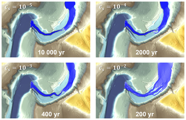
The impact of sediment grains on the riverbed is a key driver of bedrock erosion yet is rarely included in studies of landscape evolution. We propose an equation to address this issue by considering the distinction between grain lift and grain impact. We solved and analysed these equations for simple cases, such as the downstream evolution of a riverbed, and implemented them in a numerical code that simulated the retreat of a knickpoint.
David Puhl, Jens M. Turowski, Christoff Andermann, Michael Dietze, Kristen L. Cook, Gen K. Li, and Basanta R. Adhikari
EGUsphere, https://doi.org/10.5194/egusphere-2026-4202, https://doi.org/10.5194/egusphere-2026-4202, 2026
Short summary
Short summary
Large earthquakes trigger widespread landslides that increase the amount of sediment delivered to rivers. We studied suspended sediment grain sizes in a major Himalayan river basin following the 2015 Gorkha Earthquake in Nepal. We found coarser suspended sediments near heavily affected areas during the first year after the earthquake, with the signal disappearing downstream. These findings improve our understanding of how far and for how long earthquakes influence river sediment transport.
Philippe Steer, Lucas Pelascini, and Laurent Longuevergne
EGUsphere, https://doi.org/10.5194/egusphere-2026-4142, https://doi.org/10.5194/egusphere-2026-4142, 2026
Short summary
Short summary
Landslides tend to rupture in predictable size patterns, but working out where and how deep a slope will fail has remained difficult. We built a simple slope stability model, that calculates the most likely rupture depth and shape at each point on a landscape. The model reproduced real landslide size patterns. This model also revealed the slopes which are still adjusting after past geological change, like river carving or cathment divide migration, helping pinpoint landslide-prone terrain.
Aude Lurin, Philippe Steer, Fiona Clubb, and Boris Gailleton
EGUsphere, https://doi.org/10.5194/egusphere-2026-3145, https://doi.org/10.5194/egusphere-2026-3145, 2026
Short summary
Short summary
The dynamics of mountains landscapes is controled by their valley networks. The morphology of valleys, including their width, impacts how they transmit sediments and water and record tectonic or climatic signals. In order to further our understanding of the controls of valley morphology and width, we compare two automatic valley extraction methods in four regions. We then evaluate how valley width and morphology is affected dy drainage area, lithology, and the tectonic and geomorphic setting.
Helen Werner, Dirk Scherler, Tancrède P. M. Leger, Guillaume Jouvet, and Ricarda Winkelmann
The Cryosphere, 20, 2469–2484, https://doi.org/10.5194/tc-20-2469-2026, https://doi.org/10.5194/tc-20-2469-2026, 2026
Short summary
Short summary
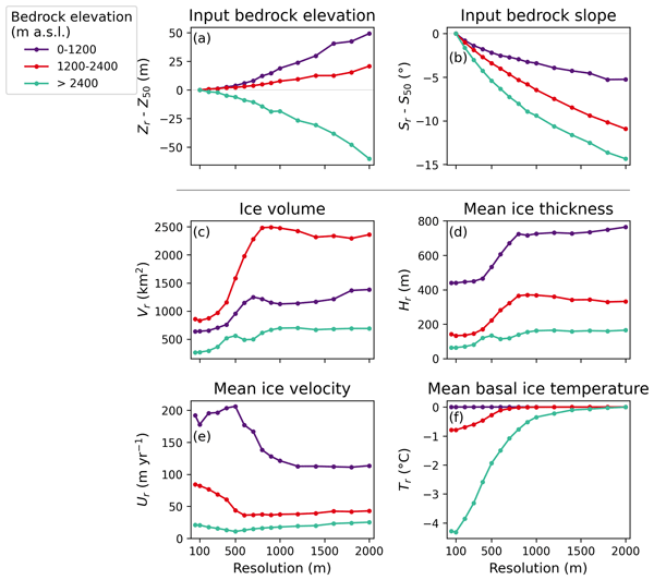
Coarse spatial resolutions reduce computational costs but poorly resolve complex topographies. Our simulations of an alpine ice field at 50 m to 2 km resolution show similar ice areas, yet much higher volumes at coarser resolutions. Resolutions of 300 m and finer accurately capture topographically constrained flow, while coarse resolutions flatten mountain slopes and peaks, affecting ice velocities, thickness, and thermal regimes which emphasizes the need for sufficiently high-resolution models.
Ron Nativ, Dimitri Lague, Paul Leroy, Laure Guerit, Thomas Bernard, Mathilde Letard, Daniel Girardeau-Montaut, Vincent Godard, Rodolphe Cattin, Olivier Payrastre, and Philippe Steer
EGUsphere, https://doi.org/10.5194/egusphere-2026-724, https://doi.org/10.5194/egusphere-2026-724, 2026
Short summary
Short summary
We mapped the riverbed through a 28 km canyon in southern France using airborne laser measurements, where field surveys are difficult and risky. By reprocessing the full recorded signal and combining it with targeted sonar checks, we recovered deeper and more complete underwater terrain than standard approaches. The resulting riverbed elevation model preserves key channel shapes needed for improved flood simulations, habitat assessment, and river management.
Marion Fournereau, Laure Guerit, Philippe Steer, Jean-Jacques Kermarrec, Paul Leroy, Christophe Lanos, Hélène Hivert, Claire Astrié, and Dimitri Lague
Earth Surf. Dynam., 14, 191–210, https://doi.org/10.5194/esurf-14-191-2026, https://doi.org/10.5194/esurf-14-191-2026, 2026
Short summary
Short summary
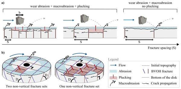
River bedrock erosion can occur by abrasion and by the removal of entire blocks. We observe that when there is no or few fractures most erosion occurs by abrasion, whereas with more fractures, blocks can be removed at once leading to different patterns of erosion and riverbed morphology. Fractures affect barely mean erosion rate but change the location and occurrence of block removal. Our results highlight how river bedrock properties influence erosion processes and thus landscape evolution.

Nazaré Suziane Soares, Carlos Alexandre Gomes Costa, Till Francke, Christian Mohr, Wolfgang Schwanghart, and Pedro Henrique Augusto Medeiros
Hydrol. Earth Syst. Sci., 30, 849–875, https://doi.org/10.5194/hess-30-849-2026, https://doi.org/10.5194/hess-30-849-2026, 2026
Short summary
Short summary
We use drone surveys to map river intermittency in reaches and classify them into "Wet", "Transition", "Dry" or "Not Determined". We train Random Forest models with 40 candidate predictors, and select altitude, drainage area, distance from dams and dynamic predictors. We separate different models based on dynamic predictors: satellite indices (a) and (b); or (c) antecedent precipitation index (30 days). Model (a) is the most successful in simulating intermittency both temporally and spatially.
Samuel Weber, Jan Beutel, Michael Dietze, Alexander Bast, Robert Kenner, Marcia Phillips, Johannes Leinauer, Simon Mühlbauer, Felix Pfluger, and Michael Krautblatter
Earth Surf. Dynam., 13, 1157–1179, https://doi.org/10.5194/esurf-13-1157-2025, https://doi.org/10.5194/esurf-13-1157-2025, 2025
Short summary
Short summary
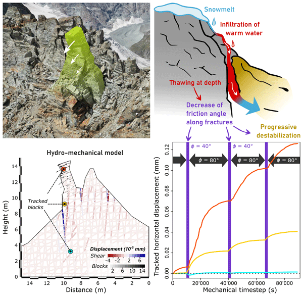
On 13 June 2023, a freestanding rock pillar on the Matterhorn collapsed after years of weakening. Our study examines this progressive destabilization by analyzing field data and integrating lab experiments into a hydro-mechanical model. We highlight the critical role of water infiltration into frozen rock, intensified by climate warming, as a widespread driver of the rising frequency of rockfalls in high mountain permafrost regions.
Thomas Geffroy, Philippe Yamato, Philippe Steer, Benjamin Guillaume, and Thibault Duretz
Solid Earth, 16, 1289–1306, https://doi.org/10.5194/se-16-1289-2025, https://doi.org/10.5194/se-16-1289-2025, 2025
Short summary
Short summary
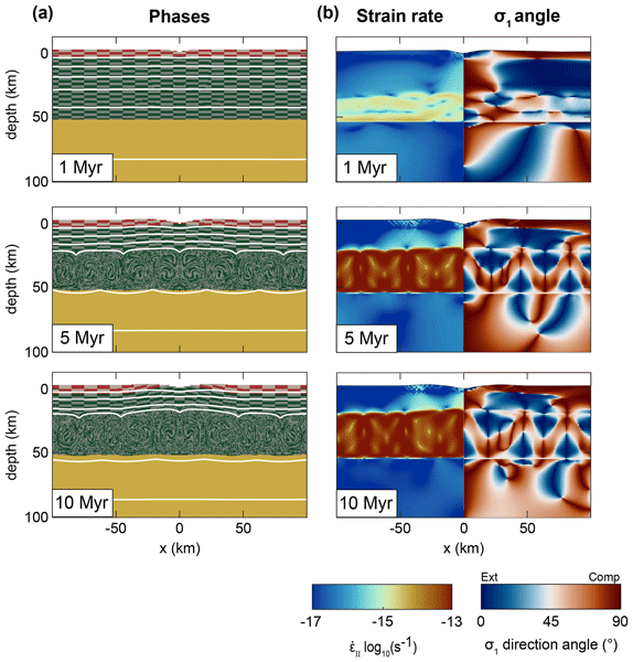
While erosion's role in mountain building is well known, deformation from valley incision in inactive regions is less understood. Using our numerical models, we show that incision alone can cause significant crustal deformation and drive lower crust exhumation. This is favored in areas with thick crust, weak lower crust, and high plateaux. Our results show surface processes can reshape Earth's surface over time.
Coline Ariagno, Philippe Steer, Pierre G. Valla, and Benjamin Campforts
Earth Surf. Dynam., 13, 1109–1132, https://doi.org/10.5194/esurf-13-1109-2025, https://doi.org/10.5194/esurf-13-1109-2025, 2025
Short summary
Short summary
This study explore the impact of landslides on Alpine terrain using a landscape evolution model called
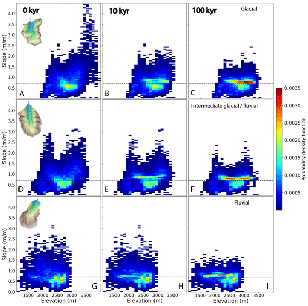
Hyland, which enables long-term topographical analysis. Our finding reveal that landslides are concentrated at two specific elevations over time and predominantly affect the highest and steepest slopes, particularly along ridges and crests. This study is part of a broader question concerning the origin of accelerated erosion during the Quaternary period.
Boris Gailleton, Philippe Steer, Philippe Davy, Wolfgang Schwanghart, and Thomas Bernard
Earth Surf. Dynam., 12, 1295–1313, https://doi.org/10.5194/esurf-12-1295-2024, https://doi.org/10.5194/esurf-12-1295-2024, 2024
Short summary
Short summary
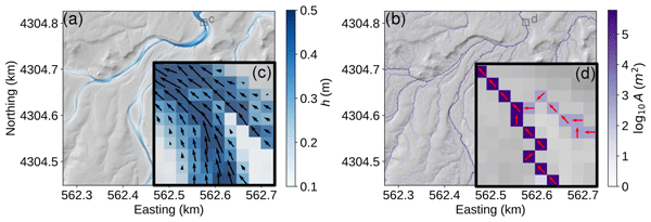
We use cutting-edge algorithms and conceptual simplifications to solve the equations that describe surface water flow. Using quantitative data on rainfall and elevation, GraphFlood calculates river width and depth and approximates erosive power, making it a suitable tool for large-scale hazard management and understanding the relationship between rivers and mountains.
Wolfgang Schwanghart, Ankit Agarwal, Kristen Cook, Ugur Ozturk, Roopam Shukla, and Sven Fuchs
Nat. Hazards Earth Syst. Sci., 24, 3291–3297, https://doi.org/10.5194/nhess-24-3291-2024, https://doi.org/10.5194/nhess-24-3291-2024, 2024
Short summary
Short summary
The Himalayan landscape is particularly susceptible to extreme events, which interfere with increasing populations and the expansion of settlements and infrastructure. This preface introduces and summarizes the nine papers that are part of the special issue,
Estimating and predicting natural hazards and vulnerabilities in the Himalayan region.
Jürgen Mey, Ravi Kumar Guntu, Alexander Plakias, Igo Silva de Almeida, and Wolfgang Schwanghart
Nat. Hazards Earth Syst. Sci., 24, 3207–3223, https://doi.org/10.5194/nhess-24-3207-2024, https://doi.org/10.5194/nhess-24-3207-2024, 2024
Short summary
Short summary
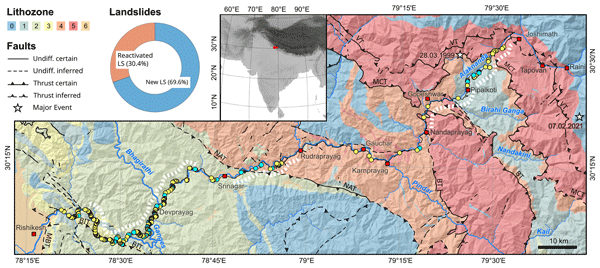
The Himalayan road network links remote areas, but fragile terrain and poor construction lead to frequent landslides. This study on the NH-7 in India's Uttarakhand region analyzed 300 landslides after heavy rainfall in 2022 . Factors like slope, rainfall, rock type and road work influence landslides. The study's model predicts landslide locations for better road maintenance planning, highlighting the risk from climate change and increased road use.
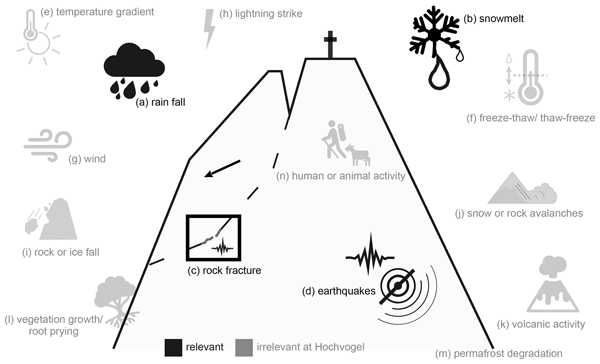
Johannes Leinauer, Michael Dietze, Sibylle Knapp, Riccardo Scandroglio, Maximilian Jokel, and Michael Krautblatter
Earth Surf. Dynam., 12, 1027–1048, https://doi.org/10.5194/esurf-12-1027-2024, https://doi.org/10.5194/esurf-12-1027-2024, 2024
Short summary
Short summary
Massive rock slope failures are a significant alpine hazard and change the Earth's surface. Therefore, we must understand what controls the preparation of such events. By correlating 4 years of slope displacements with meteorological and seismic data, we found that water from rain and snowmelt is the most important driver. Our approach is applicable to similar sites and indicates where future climatic changes, e.g. in rain intensity and frequency, may alter the preparation of slope failure.
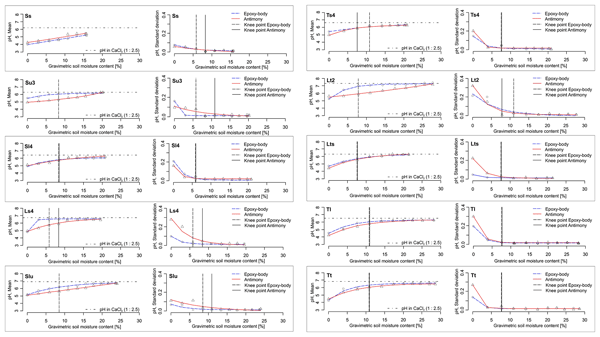
Sebastian Vogel, Katja Emmerich, Ingmar Schröter, Eric Bönecke, Wolfgang Schwanghart, Jörg Rühlmann, Eckart Kramer, and Robin Gebbers
SOIL, 10, 321–333, https://doi.org/10.5194/soil-10-321-2024, https://doi.org/10.5194/soil-10-321-2024, 2024
Short summary
Short summary
To rapidly obtain high-resolution soil pH data, pH sensors can measure the pH value directly in the field under the current soil moisture (SM) conditions. The influence of SM on pH and on its measurement quality was studied. An SM increase causes a maximum pH increase of 1.5 units. With increasing SM, the sensor pH value approached the standard pH value measured in the laboratory. Thus, at high soil moisture, calibration of the sensor pH values to the standard pH value is negligible.
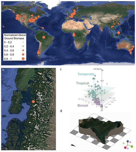
Christian H. Mohr, Michael Dietze, Violeta Tolorza, Erwin Gonzalez, Benjamin Sotomayor, Andres Iroume, Sten Gilfert, and Frieder Tautz
Biogeosciences, 21, 1583–1599, https://doi.org/10.5194/bg-21-1583-2024, https://doi.org/10.5194/bg-21-1583-2024, 2024
Short summary
Short summary
Coastal temperate rainforests, among Earth’s carbon richest biomes, are systematically underrepresented in the global network of critical zone observatories (CZOs). Introducing here a first CZO in the heart of the Patagonian rainforest, Chile, we investigate carbon sink functioning, biota-driven landscape evolution, fluxes of matter and energy, and disturbance regimes. We invite the community to join us in cross-disciplinary collaboration to advance science in this particular environment.
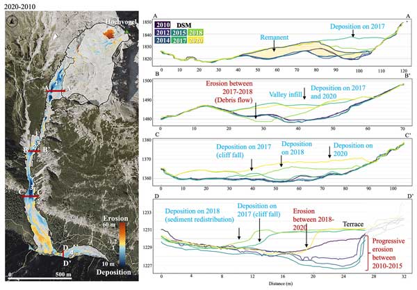
Natalie Barbosa, Johannes Leinauer, Juilson Jubanski, Michael Dietze, Ulrich Münzer, Florian Siegert, and Michael Krautblatter
Earth Surf. Dynam., 12, 249–269, https://doi.org/10.5194/esurf-12-249-2024, https://doi.org/10.5194/esurf-12-249-2024, 2024
Short summary
Short summary
Massive sediment pulses in catchments are a key alpine multi-risk component. Combining high-resolution aerial imagery and seismic information, we decipher a multi-stage >130.000 m³ rockfall and subsequent sediment pulses over 4 years, reflecting sediment deposition up to 10 m, redistribution in the basin, and finally debouchure to the outlet. This study provides generic information on spatial and temporal patterns of massive sediment pulses in highly charged alpine catchments.
Anna-Maartje de Boer, Wolfgang Schwanghart, Jürgen Mey, Basanta Raj Adhikari, and Tony Reimann
Geochronology, 6, 53–70, https://doi.org/10.5194/gchron-6-53-2024, https://doi.org/10.5194/gchron-6-53-2024, 2024
Short summary
Short summary
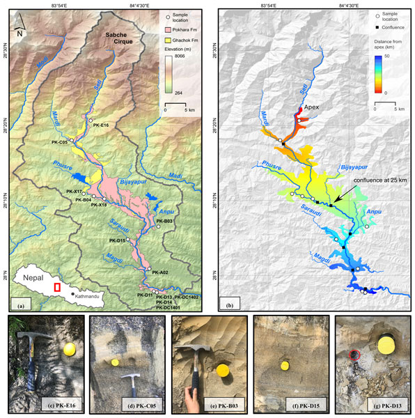
This study tested the application of single-grain feldspar luminescence for dating and reconstructing sediment dynamics of an extreme mass movement event in the Himalayan mountain range. Our analysis revealed that feldspar signals can be used to estimate the age range of the deposits if the youngest subpopulation from a sample is retrieved. The absence of clear spatial relationships with our bleaching proxies suggests that sediments were transported under extremely limited light exposure.
Emma L. S. Graf, Hugh D. Sinclair, Mikaël Attal, Boris Gailleton, Basanta Raj Adhikari, and Bishnu Raj Baral
Earth Surf. Dynam., 12, 135–161, https://doi.org/10.5194/esurf-12-135-2024, https://doi.org/10.5194/esurf-12-135-2024, 2024
Short summary
Short summary
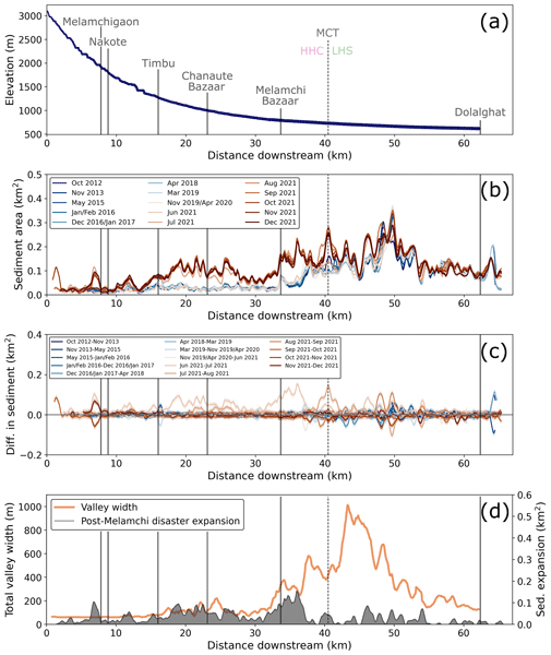
Using satellite images, we show that, unlike other examples of earthquake-affected rivers, the rivers of central Nepal experienced little increase in sedimentation following the 2015 Gorkha earthquake. Instead, a catastrophic flood occurred in 2021 that buried towns and agricultural land under up to 10 m of sediment. We show that intense storms remobilised glacial sediment from high elevations causing much a greater impact than flushing of earthquake-induced landslides.
Boris Gailleton, Luca C. Malatesta, Guillaume Cordonnier, and Jean Braun
Geosci. Model Dev., 17, 71–90, https://doi.org/10.5194/gmd-17-71-2024, https://doi.org/10.5194/gmd-17-71-2024, 2024
Short summary
Short summary
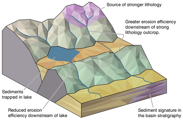
This contribution presents a new method to numerically explore the evolution of mountain ranges and surrounding areas. The method helps in monitoring with details on the timing and travel path of material eroded from the mountain ranges. It is particularly well suited to studies juxtaposing different domains – lakes or multiple rock types, for example – and enables the combination of different processes.
Jürgen Mey, Wolfgang Schwanghart, Anna-Maartje de Boer, and Tony Reimann
Geochronology, 5, 377–389, https://doi.org/10.5194/gchron-5-377-2023, https://doi.org/10.5194/gchron-5-377-2023, 2023
Short summary
Short summary
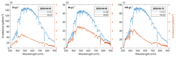
This study presents the results of an outdoor flume experiment to evaluate the effect of turbidity on the bleaching of fluvially transported sediment. Our main conclusions are that even small amounts of sediment lead to a substantial change in the intensity and frequency distribution of light within the suspension and that flow turbulence is an important prerequisite for bleaching grains during transport.
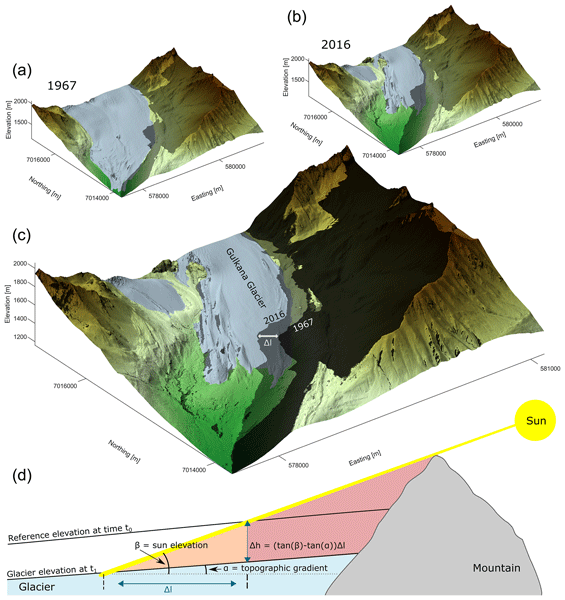
Monika Pfau, Georg Veh, and Wolfgang Schwanghart
The Cryosphere, 17, 3535–3551, https://doi.org/10.5194/tc-17-3535-2023, https://doi.org/10.5194/tc-17-3535-2023, 2023
Short summary
Short summary
Cast shadows have been a recurring problem in remote sensing of glaciers. We show that the length of shadows from surrounding mountains can be used to detect gains or losses in glacier elevation.

Richard Ott, Sean F. Gallen, and David Helman
Earth Surf. Dynam., 11, 247–257, https://doi.org/10.5194/esurf-11-247-2023, https://doi.org/10.5194/esurf-11-247-2023, 2023
Short summary
Short summary
We compile data on carbonate denudation, the sum of mechanical erosion and chemical weathering, from cosmogenic nuclides and use them in conjunction with weathering data to constrain the partitioning of denudation into erosion and weathering. We show how carbonate erosion and weathering respond to different climatic and tectonic conditions and find that variations in denudation partitioning can be used to explain the vastly different morphology of carbonate landscapes on Earth.
Jürgen Mey, Ravi Kumar Guntu, Alexander Plakias, Igo Silva de Almeida, and Wolfgang Schwanghart
Nat. Hazards Earth Syst. Sci. Discuss., https://doi.org/10.5194/nhess-2022-295, https://doi.org/10.5194/nhess-2022-295, 2023
Manuscript not accepted for further review
Short summary
Short summary
The current socioeconomic development in the Himalayan region leads to a rapid expansion of the road network and an increase in the exposure to landslides. Our study along the NH-7 demonstrates the scale of this challenge as we detect more than one partially or fully road-blocking landslide per road kilometer. We identify the main controlling variables, i.e. slope angle, rainfall amount and lithology. As our approach uses a minimum of data, it can be extended to more complicated road networks.

Fabian Walter, Elias Hodel, Erik S. Mannerfelt, Kristen Cook, Michael Dietze, Livia Estermann, Michaela Wenner, Daniel Farinotti, Martin Fengler, Lukas Hammerschmidt, Flavia Hänsli, Jacob Hirschberg, Brian McArdell, and Peter Molnar
Nat. Hazards Earth Syst. Sci., 22, 4011–4018, https://doi.org/10.5194/nhess-22-4011-2022, https://doi.org/10.5194/nhess-22-4011-2022, 2022
Short summary
Short summary
Debris flows are dangerous sediment–water mixtures in steep terrain. Their formation takes place in poorly accessible terrain where instrumentation cannot be installed. Here we propose to monitor such source terrain with an autonomous drone for mapping sediments which were left behind by debris flows or may contribute to future events. Short flight intervals elucidate changes of such sediments, providing important information for landscape evolution and the likelihood of future debris flows.
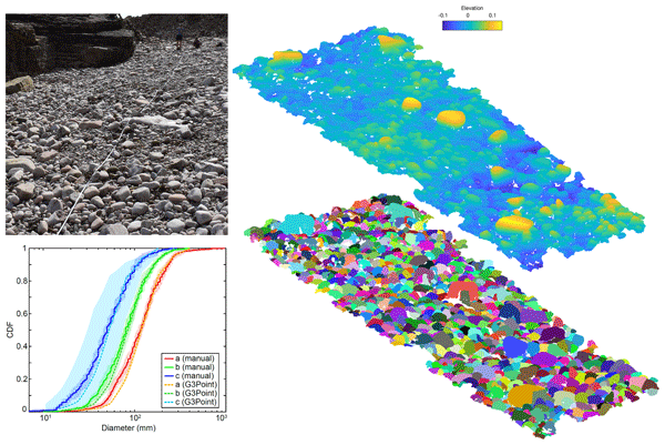
Philippe Steer, Laure Guerit, Dimitri Lague, Alain Crave, and Aurélie Gourdon
Earth Surf. Dynam., 10, 1211–1232, https://doi.org/10.5194/esurf-10-1211-2022, https://doi.org/10.5194/esurf-10-1211-2022, 2022
Short summary
Short summary
The morphology and size of sediments influence erosion efficiency, sediment transport and the quality of aquatic ecosystem. In turn, the spatial evolution of sediment size provides information on the past dynamics of erosion and sediment transport. We have developed a new software which semi-automatically identifies and measures sediments based on 3D point clouds. This software is fast and efficient, offering a new avenue to measure the geometrical properties of large numbers of sediment grains.
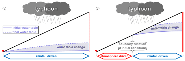
Lucas Pelascini, Philippe Steer, Maxime Mouyen, and Laurent Longuevergne
Nat. Hazards Earth Syst. Sci., 22, 3125–3141, https://doi.org/10.5194/nhess-22-3125-2022, https://doi.org/10.5194/nhess-22-3125-2022, 2022
Short summary
Short summary
Landslides represent a major natural hazard and are often triggered by typhoons. We present a new 2D model computing the respective role of rainfall infiltration, atmospheric depression and groundwater in slope stability during typhoons. The results show rainfall is the strongest factor of destabilisation. However, if the slope is fully saturated, near the toe of the slope or during the wet season, rainfall infiltration is limited and atmospheric pressure change can become the dominant factor.

Richard F. Ott, Sean F. Gallen, and Darryl E. Granger
Geochronology, 4, 455–470, https://doi.org/10.5194/gchron-4-455-2022, https://doi.org/10.5194/gchron-4-455-2022, 2022
Short summary
Short summary
Cosmogenic nuclides are a tool to quantify denudation – the total removal of mass from near the Earth's surface. Chemical weathering can introduce biases to cosmogenic-nuclide-based denudation rates measurements. Here, we investigate the effects of weathering on cosmogenic nuclides and develop tools to correct for this influence. Our results highlight which additional measurements are required to determine accurate denudation rates in regions where weathering is not negligible.
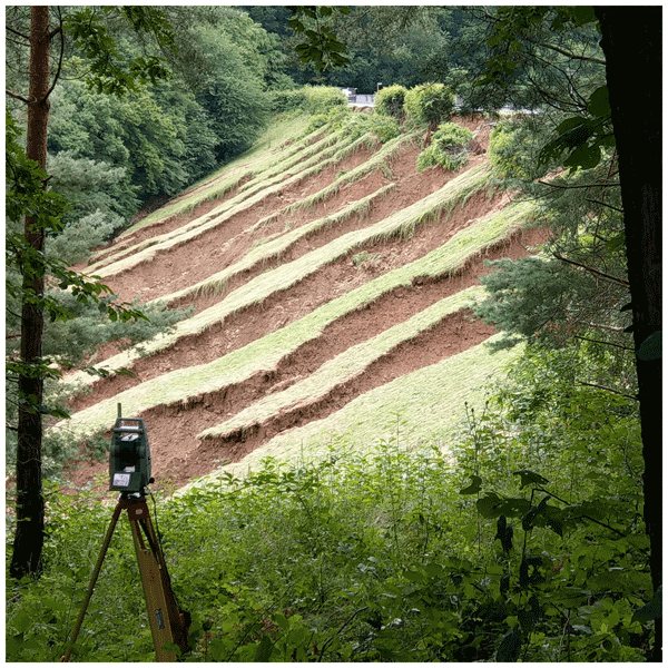
Michael Dietze, Rainer Bell, Ugur Ozturk, Kristen L. Cook, Christoff Andermann, Alexander R. Beer, Bodo Damm, Ana Lucia, Felix S. Fauer, Katrin M. Nissen, Tobias Sieg, and Annegret H. Thieken
Nat. Hazards Earth Syst. Sci., 22, 1845–1856, https://doi.org/10.5194/nhess-22-1845-2022, https://doi.org/10.5194/nhess-22-1845-2022, 2022
Short summary
Short summary
The flood that hit Europe in July 2021, specifically the Eifel, Germany, was more than a lot of fast-flowing water. The heavy rain that fell during the 3 d before also caused the slope to fail, recruited tree trunks that clogged bridges, and routed debris across the landscape. Especially in the upper parts of the catchments the flood was able to gain momentum. Here, we discuss how different landscape elements interacted and highlight the challenges of holistic future flood anticipation.

Michael Dietze, Sebastian Kreutzer, Margret C. Fuchs, and Sascha Meszner
Geochronology, 4, 323–338, https://doi.org/10.5194/gchron-4-323-2022, https://doi.org/10.5194/gchron-4-323-2022, 2022
Short summary
Short summary
The R package sandbox is a collection of functions that allow the creation, sampling and analysis of fully virtual sediment sections, like having a virtual twin of real-world deposits. This article introduces the concept, features, and workflows required to use sandbox. It shows how a real-world sediment section can be mapped into the model and subsequently addresses a series of theoretical and practical questions, exploiting the flexibility of the model framework.
Cited articles
Arakawa, M., Saiki, T., Wada, K., Ogawa, K., Kadono, T., Shirai, K., Sawada, H., Ishibashi, K., Honda, R., Sakatani, N., Iijima, Y., Okamoto, C., Yano, H., Takagi, Y., Hayakawa, M., Michel, P., Jutzi, M., Shimaki, Y., Kimura, S., Mimasu, Y., Toda, T., Imamura, H., Nakazawa, S., Hayakawa, H., Sugita, S., Morota, T., Kameda, S., Tatsumi, E., Cho, Y., Yoshioka, K., Yokota, Y., Matsuoka, M., Yamada, M., Kouyama, T., Honda, C., Tsuda, Y., Watanabe, S., Yoshikawa, M., Tanaka, S., Terui, F., Kikuchi, S., Yamaguchi, T., Ogawa, N., Ono, G., Yoshikawa, K., Takahashi, T., Takei, Y., Fujii, A., Takeuchi, H., Yamamoto, Y., Okada, T., Hirose, C., Hosoda, S., Mori, O., Shimada, T., Soldini, S., Tsukizaki, R., Iwata, T., Ozaki, M., Abe, M., Namiki, N., Kitazato, K., Tachibana, S., Ikeda, H., Hirata, N., Hirata, N., Noguchi, R., and Miura, A.: An artificial impact on the asteroid (162173) Ryugu formed a crater in the gravity-dominated regime, Science, 368, 67–71, https://doi.org/10.1126/science.aaz1701, 2020. a
Arge, L., Chase, J. S., Halpin, P., Toma, L., Vitter, J. S., Urban, D., and Wickremesinghe, R.: Efficient flow computation on massive grid terrain datasets, GeoInformatica, 7, 283–313, https://doi.org/10.1023/a:1025526421410, 2003. a
Armitage, J. J.: Short communication: flow as distributed lines within the landscape, Earth Surf. Dynam., 7, 67–75, https://doi.org/10.5194/esurf-7-67-2019, 2019. a
Barker, M., Chue Hong, N. P., Katz, D. S., Lamprecht, A.-L., Martinez-Ortiz, C., Psomopoulos, F., Harrow, J., Castro, L. J., Gruenpeter, M., Martinez, P. A., and Honeyman, T.: Introducing the FAIR principles for research software, Scientific Data, 9, 622, https://doi.org/10.1038/s41597-022-01710-x, 2022. a, b
Barnes, R.: Parallel priority-flood depression filling for trillion cell digital elevation models on desktops or clusters, Comput. Geosci., 96, 56–68, https://doi.org/10.1016/j.cageo.2016.07.001, 2016. a
Barnes, R.: Parallel non-divergent flow accumulation for trillion cell digital elevation models on desktops or clusters, Environ. Modell. Softw., 92, 202–212, https://doi.org/10.1016/j.envsoft.2017.02.022, 2017. a
Barnhart, K. R., Hutton, E. W. H., Tucker, G. E., Gasparini, N. M., Istanbulluoglu, E., Hobley, D. E. J., Lyons, N. J., Mouchene, M., Nudurupati, S. S., Adams, J. M., and Bandaragoda, C.: Short communication: Landlab v2.0: a software package for Earth surface dynamics, Earth Surf. Dynam., 8, 379–397, https://doi.org/10.5194/esurf-8-379-2020, 2020. a, b
Barr, E. T., Harman, M., McMinn, P., Shahbaz, M., and Yoo, S.: The Oracle Problem in Software Testing: A Survey, IEEE T. Software Eng., 41, 507–525, https://doi.org/10.1109/TSE.2014.2372785, 2015. a
Bartelheimer, C., zur Heiden, P., Lüttenberg, H., and Beverungen, D.: Systematizing the lexicon of platforms in information systems: a data-driven study, Electron. Mark., 32, 375–396, https://doi.org/10.1007/s12525-022-00530-6, 2022. a
Beck, K.: Test-Driven Development: By Example, Addison-Wesley, ISBN 0-321-14653-0, 2003. a
Berlin, M. M. and Anderson, R. S.: Modeling of knickpoint retreat on the Roan Plateau, western Colorado, J. Geophys. Res.-Earth, 112, https://doi.org/10.1029/2006JF000553, 2007. a
Bernhardt, A. and Schwanghart, W.: Where and why do submarine canyons remain connected to the shore during sea-level rise? Insights from global topographic analysis and Bayesian regression, Geophys. Res. Lett., 48, e2020GL092234, https://doi.org/10.1029/2020GL092234, 2021. a
Bernhardt, A. and Schwanghart, W.: Seafloor slopes control submarine canyon distribution: a global analysis, Science Advances, 11, eadv3942, https://doi.org/10.1126/sciadv.adv3942, 2025. a
Bertrand, P., Vihtakari, M., Yoccoz, N. G., Strøm, H., Descamps, S., Steen, H., Duarte, P., Hop, H., Assmy, P., Patrick, S. C., Bertrand, P., Bêty, J., Kohler, J., Pelt, W. v., Harris, S. M., Wold, A., and Moholdt, G.: Feeding at the front line: interannual variation in the use of glacier fronts by foraging black-legged kittiwakes, Mar. Ecol. Prog. Ser., 677, 197–208, https://doi.org/10.3354/meps13869, 2021. a
Bovy, B. and Lange, R.: fastscape-lem/fastscape: Release v0.1.0, Version 0.1.0, Zenodo [code], https://doi.org/10.5281/zenodo.8375653, 2023. a
Braun, J. and Willett, S. D.: A very efficient O(n), implicit and parallel method to solve the stream power equation governing fluvial incision and landscape evolution, Geomorphology, 180–181, 170–179, https://doi.org/10.1016/j.geomorph.2012.10.008, 2013. a
Campforts, B., Schwanghart, W., and Govers, G.: Accurate simulation of transient landscape evolution by eliminating numerical diffusion: the TTLEM 1.0 model, Earth Surf. Dynam., 5, 47–66, https://doi.org/10.5194/esurf-5-47-2017, 2017. a
Chen, T. Y., Kuo, F.-C., Liu, H., Poon, P.-L., Towey, D., Tse, T. H., and Zhou, Z. Q.: Metamorphic testing: a review of challenges and opportunities, ACM Comput. Surv., 51, https://doi.org/10.1145/3143561, 2018. a
Culberg, R., Schroeder, D. M., and Steinbrügge, G.: Double ridge formation over shallow water sills on Jupiter's moon Europa, Nat. Commun., 13, 2007, https://doi.org/10.1038/s41467-022-29458-3, 2022. a, b
Davy, P., Croissant, T., and Lague, D.: A precipiton method to calculate river hydrodynamics, with applications to flood prediction, landscape evolution models, and braiding instabilities, J. Geophys. Res.-Earth, 122, 1491–1512, https://doi.org/10.1002/2016JF004156, 2017. a
Dawson, N., Fischer, J., Kuhn, M., Pasotti, A., Rouzaud, D., mhugent, Bruy, A., Sutton, T., Dobias, M., Pellerin, M., Rouault, E., Olaya, V., Blottiere, P., Macho, W., Cabieces, J., Blazek, R., Bartoletti, L., Sherman, G., Sant-anna, H., Woodrow, N., signedav, Natsis, S., rldhont, Felder, J., Shaffer, L., Belgacem, N., Santilli, S., Larosa, S., Mani, S., and Jurgiel, B.: qgis/QGIS: 4.2.2, Zenodo [code], https://doi.org/10.5281/zenodo.22144220, 2026. a
Delchiaro, M., Ruscitto, V., Schwanghart, W., Brignone, E., Piacentini, D., and Troiani, F.: BankfullMapper: a semi-automated MATLAB tool on high-resolution digital terrain models for spatio-temporal monitoring of bankfull geometry and discharge, Comput. Geosci., 205, 106001, https://doi.org/10.1016/j.cageo.2025.106001, 2025. a
European Space Agency: Copernicus Global Digital Elevation Model, OpenTopography [data set], https://doi.org/10.5069/G9028PQB, 2024. a, b
Fabian, R.: Data-oriented design, https://www.dataorienteddesign.com/dodbook (last access: 6 November 2026), 2018. a
Falco, N., Wainwright, H. M., Chadwick, K. D., Dafflon, B., Enquist, B. J., Uhlemann, S., Breckheimer, I. K., Lamb, J., Chen, J., Tuvshintugs, O., Balde, A., Williams, K. H., and Brodie, E. L.: Ecoimaging: advanced sensing to investigate plant and abiotic hierarchical spatial patterns in mountainous watersheds, SSRN, https://doi.org/10.2139/ssrn.4779350, 2024. a
Feathers, M. C.: Working Effectively with Legacy Code, Pearson, ISBN 9780131177055, 2004. a
Fisher, P. F. and Tate, N. J.: Causes and consequences of error in digital elevation models, Progress in Physical Geography: Earth and Environment, 30, 467–489, https://doi.org/10.1191/0309133306pp492ra, 2006. a
Forte, A. M. and Whipple, K. X.: Short communication: The Topographic Analysis Kit (TAK) for TopoToolbox, Earth Surf. Dynam., 7, 87–95, https://doi.org/10.5194/esurf-7-87-2019, 2019. a
Gailleton, B., Steer, P., Davy, P., Schwanghart, W., and Bernard, T.: GraphFlood 1.0: an efficient algorithm to approximate 2D hydrodynamics for landscape evolution models, Earth Surf. Dynam., 12, 1295–1313, https://doi.org/10.5194/esurf-12-1295-2024, 2024. a, b, c
Gallen, S. F.: ChiProfiler, Zenodo [code], https://doi.org/10.5281/zenodo.597335, 2017. a
GDAL/OGR contributors: GDAL/OGR Geospatial Data Abstraction softwareLibrary, Open Source Geospatial Foundation, Zenodo [code], https://doi.org/10.5281/zenodo.5884351, 2025. a
Gillen, M. N., Ashton, A. D., and Perron, J. T.: Rivers influence reef pass formation in the Society Islands, Geophys. Res. Lett., 52, e2025GL114881, https://doi.org/10.1029/2025GL114881, 2025. a
Gillies, S. et al.: Rasterio: geospatial raster I/O for Python programmers, GitHub [code], https://github.com/rasterio/rasterio (last access: 6 November 2026), 2013. a
Goldstein, H., Cutler, J. W., Dickstein, D., Pierce, B. C., and Head, A.: Property-based testing in practice, in: Proceedings of the IEEE/ACM 46th International Conference on Software Engineering, ICSE '24, Association for Computing Machinery, New York, NY, USA, ISBN 9798400702174, https://doi.org/10.1145/3597503.3639581, 2024. a
Greene, C. A., Gwyther, D. E., and Blankenship, D. D.: Antarctic mapping tools for Matlab, Comput. Geosci., 104, 151–157, https://doi.org/10.1016/j.cageo.2016.08.003, 2017. a
Grohmann, C. H., Lecours, V., and Reuter, H. I.: Overview of software packages used in geomorphometry, in: Geomorphometry, edited by: Reuter, H. I., Grohmann, C. H., and Lecours, V., Vol. 37 of Developments in Soil Science, Elsevier, https://doi.org/10.1016/B978-0-44-333376-7.00021-5, 371–383, 2026. a
Hergarten, S.: Scaling between volume and runout of rock avalanches explained by a modified Voellmy rheology, Earth Surf. Dynam., 12, 219–229, https://doi.org/10.5194/esurf-12-219-2024, 2024a. a
Hergarten, S.: MinVoellmy v1: a lightweight model for simulating rapid mass movements based on a modified Voellmy rheology, Geosci. Model Dev., 17, 781–794, https://doi.org/10.5194/gmd-17-781-2024, 2024b. a
Hergarten, S. and Neugebauer, H. J.: Self-organized critical drainage networks, Phys. Rev. Lett., 86, 2689–2692, https://doi.org/10.1103/PhysRevLett.86.2689, 2001. a
Hijmans, R. J.: terra: Spatial Data Analysis, r package version 1.8-58, https://rspatial.org/ (last access: 6 November 2026), 2025. a
Hobley, D. E. J., Adams, J. M., Nudurupati, S. S., Hutton, E. W. H., Gasparini, N. M., Istanbulluoglu, E., and Tucker, G. E.: Creative computing with Landlab: an open-source toolkit for building, coupling, and exploring two-dimensional numerical models of Earth-surface dynamics, Earth Surf. Dynam., 5, 21–46, https://doi.org/10.5194/esurf-5-21-2017, 2017. a, b
Hunter, B. D., Roering, J. J., Silva, L. C. R., and Moreland, K. C.: Geomorphic controls on the abundance and persistence of soil organic carbon pools in erosional landscapes, Nat. Geosci., 17, 151–157, https://doi.org/10.1038/s41561-023-01365-2, 2024. a
Hutton, E., Barnhart, K., Hobley, D., Tucker, G., Nudurupati, S. S., Adams, J., Gasparini, N. M., Shobe, C., Strauch, R., Knuth, J., margauxmouchene, Lyons, N., DavidLitwin, Glade, R., Giuseppecipolla95, Manaster, A., alangston, Thyng, K., and Rengers, F.: landlab/landlab: Mrs. Weasley, Version v2.0.1, Zenodo [code], https://doi.org/10.5281/zenodo.3776837, 2020. a, b
Institut national de l'information géographique et forestière (IGN): BD ALTI® 25 m, https://cartes.gouv.fr/rechercher-une-donnee/dataset/IGNF_BD-ALTI (last access: 6 November 2026), 2024. a
Jakob, W., Rhinelander, J., and Moldovan, D.: pybind11 – Seamless operability between C++11 and Python, GitHub [code], https://github.com/pybind/pybind11 (last access: 6 November 2026), 2017. a
Karlstrom, L. and Yang, K.: Fluvial supraglacial landscape evolution on the Greenland Ice Sheet, Geophys. Res. Lett., 43, 2683–2692, https://doi.org/10.1002/2016GL067697, 2016. a
Kearney, W., Gailleton, B., Arnau, G., Bringezu, T., Katerndahl, F., Lenz, K., and Schwanghart, W.: TopoToolbox/libtopotoolbox: 2026-W20, Zenodo [code], https://doi.org/10.5281/zenodo.20269315, 2026a. a, b
Kearney, W., Gailleton, B., Bringezu, T., Arnau, G., Malatesta, L., Faure, F., and Ye, X.: TopoToolbox/pytopotoolbox: v0.0.11, Zenodo [code], https://doi.org/10.5281/zenodo.20209621, 2026b. a, b
Kearney, W., Schwanghart, W., and Gailleton, B.: TopoToolbox/gallery: release-20260518-4, Zenodo [code], https://doi.org/10.5281/zenodo.20270725, 2026c. a
Kearney, W., Schwanghart, W., Scherler, D., Ott, R., and Arnau, G.: TopoToolbox/topotoolbox3: release-20260521-1, Zenodo [code], https://doi.org/10.5281/zenodo.20322894, 2026d. a, b
Kelly, D. and Sanders, R.: The challenge of testing scientific software, in: Conference for the Association of Software Testing, https://associationforsoftwaretesting.org/conference/cast-archive/cast-2008/ (last access: 6 November 2026), 2008. a
Kneib, M., Dehecq, A., Brun, F., Karbou, F., Charrier, L., Leinss, S., Wagnon, P., and Maussion, F.: Mapping and characterization of avalanches on mountain glaciers with Sentinel-1 satellite imagery, The Cryosphere, 18, 2809–2830, https://doi.org/10.5194/tc-18-2809-2024, 2024. a
Lai, L. S.-H., Booth, A. M., Duvall, A. R., and Herzig, E.: Short communication: Multiscale topographic complexity analysis with pyTopoComplexity, Earth Surf. Dynam., 13, 417–435, https://doi.org/10.5194/esurf-13-417-2025, 2025. a
Lindsay, J.: Whitebox GAT: a case study in geomorphometric analysis, Comput. Geosci., 95, 75–84, https://doi.org/10.1016/j.cageo.2016.07.003, 2016. a
MacKie, E. J., Schroeder, D. M., Zuo, C., Yin, Z., and Caers, J.: Stochastic modeling of subglacial topography exposes uncertainty in water routing at Jakobshavn Glacier, J. Glaciol., 67, 75–83, https://doi.org/10.1017/jog.2020.84, 2021. a, b
Mudd, S. M., Clubb, F. J., Grieve, S. W. D., Milodowski, D. T., Hurst, M. D., Gailleton, B., and Valters, D. A.: LSDTopoTools2, Zenodo [code], https://doi.org/10.5281/zenodo.3245041, 2019. a
O'Callaghan, J. F. and Mark, D. M.: The extraction of drainage networks from digital elevation data, Comput. Vision Graph., 28, 323–344, https://doi.org/10.1016/S0734-189X(84)80011-0, 1984. a
Perron, J. T. and Royden, L.: An integral approach to bedrock river profile analysis, Earth Surf. Proc. Land., 38, 570–576, https://doi.org/10.1002/esp.3302, 2013. a, b, c, d
Purinton, B. and Bookhagen, B.: Validation of digital elevation models (DEMs) and comparison of geomorphic metrics on the southern Central Andean Plateau, Earth Surf. Dynam., 5, 211–237, https://doi.org/10.5194/esurf-5-211-2017, 2017. a
Remy, N.: S-GeMS: The Stanford geostatistical modeling software: a tool for new algorithms development, in: Geostatistics Banff 2004, edited by: Leuangthong, O. and Deutsch, C. V., Springer Netherlands, Dordrecht, 865–871, https://doi.org/10.1007/978-1-4020-3610-1_89, ISBN 978-1-4020-3610-1, 2005. a
Rocklin, M.: Dask: parallel computations with blocked algorithms and task scheduling, in: Proceedings of the 14th Python in Science Conference, https://doi.org/10.25080/Majora-7b98e3ed-013, 2015. a
Scherler, D. and Schwanghart, W.: Drainage divide networks – Part 1: Identification and ordering in digital elevation models, Earth Surf. Dynam., 8, 245–259, https://doi.org/10.5194/esurf-8-245-2020, 2020. a
Schwanghart, W. and Kuhn, N. J.: TopoToolbox: a set of Matlab functions for topographic analysis, Environ. Modell. Softw., 25, 770–781, https://doi.org/10.1016/j.envsoft.2009.12.002, 2010. a
Schwanghart, W. and Scherler, D.: Short Communication: TopoToolbox 2 – MATLAB-based software for topographic analysis and modeling in Earth surface sciences, Earth Surf. Dynam., 2, 1–7, https://doi.org/10.5194/esurf-2-1-2014, 2014. a, b, c, d
Schwanghart, W. and Scherler, D.: Bumps in river profiles: uncertainty assessment and smoothing using quantile regression techniques, Earth Surf. Dynam., 5, 821–839, https://doi.org/10.5194/esurf-5-821-2017, 2017. a
Schwanghart, W., Groom, G., Kuhn, N. J., and Heckrath, G.: Flow network derivation from a high resolution DEM in a low relief, agrarian landscape, Earth Surf. Proc. Land., 38, 1576–1586, https://doi.org/10.1002/esp.3452, 2013. a, b
Schwanghart, W., Molkenthin, C., and Scherler, D.: A systematic approach and software for the analysis of point patterns on river networks, Earth Surf. Proc. Land., 46, 1847–1862, https://doi.org/10.1002/esp.5127, 2021. a
Smith, T., Rheinwalt, A., and Bookhagen, B.: TopoMetricUncertainty – Calculating Topographic Metric Uncertainty and Optimal Grid Resolution, GFZ Data Services [data set], https://doi.org/10.5880/fidgeo.2019.017, 2019. a
Steer, P.: Short communication: Analytical models for 2D landscape evolution, Earth Surf. Dynam., 9, 1239–1250, https://doi.org/10.5194/esurf-9-1239-2021, 2021. a
Stolle, A., Schwanghart, W., Andermann, C., Bernhardt, A., Fort, M., Jansen, J. D., Wittmann, H., Merchel, S., Rugel, G., Adhikari, B. R., and Korup, O.: Protracted river response to medieval earthquakes, Earth Surf. Proc. Land., 44, 331–341, https://doi.org/10.1002/esp.4517, 2019. a
Swirad, Z. M. and Young, A. P.: CliffDelineaTool v1.2.0: an algorithm for identifying coastal cliff base and top positions, Geosci. Model Dev., 15, 1499–1512, https://doi.org/10.5194/gmd-15-1499-2022, 2022. a
Tangi, M., Schmitt, R., Bizzi, S., and Castelletti, A.: The CASCADE toolbox for analyzing river sediment connectivity and management, Environ. Modell. Softw., 119, 400–406, https://doi.org/10.1016/j.envsoft.2019.07.008, 2019. a
Tarboton, D. G. and Baker, M. E.: Toward an algebra from terrain-based flow analysis, in: Representing, Modeling and Visualizing the Natural Environment, edited by: Mount, N., Harvey, G. L., Aplin, P., and Priestnall, G., CRC Press, https://doi.org/10.1201/9781420055504, 2008. a
Tennant, E., Jenkins, S. F., and Biass, S.: FlowDIR: a MATLAB tool for rapidly and probabilistically forecasting the travel directions of volcanic flows, Journal of Applied Volcanology, 12, 10, https://doi.org/10.1186/s13617-023-00136-3, 2023. a, b
The MathWorks Inc.: MATLAB, https://www.mathworks.com (last access: 6 November 2026), 2022. a
Val, P., Lyons, N. J., Gasparini, N., Willenbring, J. K., and Albert, J. S.: Landscape evolution as a diversification driver in freshwater fishes, Frontiers in Ecology and Evolution, 9, https://doi.org/10.3389/fevo.2021.788328, 2022. a
Van Wyk de Vries, M., Romero, M., Penprase, S. B., Ng, G.-H. C., and Wickert, A. D.: Increasing rate of 21st century volume loss of the Patagonian icefields measured from proglacial river discharge, J. Glaciol., 69, 1187–1202, https://doi.org/10.1017/jog.2023.9, 2023. a
Voigtländer, A., Rheinwalt, A., and Tofelde, S.: Quantifying Earth's topography: steeper and larger than projected in digital terrain models, Geophys. Res. Lett., 51, e2024GL109517, https://doi.org/10.1029/2024GL109517, 2024. a
Wainwright, H. M., Steefel, C., Trutner, S. D., Henderson, A. N., Nikolopoulos, E. I., Wilmer, C. F., Chadwick, K. D., Falco, N., Schaettle, K. B., Brown, J. B., Steltzer, H., Williams, K. H., Hubbard, S. S., and Enquist, B. J.: Satellite-derived foresummer drought sensitivity of plant productivity in Rocky Mountain headwater catchments: spatial heterogeneity and geological-geomorphological control, Environ. Res. Lett., 15, 084018, https://doi.org/10.1088/1748-9326/ab8fd0, 2020. a
Wainwright, H. M., Uhlemann, S., Franklin, M., Falco, N., Bouskill, N. J., Newcomer, M. E., Dafflon, B., Siirila-Woodburn, E. R., Minsley, B. J., Williams, K. H., and Hubbard, S. S.: Watershed zonation through hillslope clustering for tractably quantifying above- and below-ground watershed heterogeneity and functions, Hydrol. Earth Syst. Sci., 26, 429–444, https://doi.org/10.5194/hess-26-429-2022, 2022. a
Ward, A. S., Wondzell, S. M., Schmadel, N. M., Herzog, S., Zarnetske, J. P., Baranov, V., Blaen, P. J., Brekenfeld, N., Chu, R., Derelle, R., Drummond, J., Fleckenstein, J. H., Garayburu-Caruso, V., Graham, E., Hannah, D., Harman, C. J., Hixson, J., Knapp, J. L. A., Krause, S., Kurz, M. J., Lewandowski, J., Li, A., Martí, E., Miller, M., Milner, A. M., Neil, K., Orsini, L., Packman, A. I., Plont, S., Renteria, L., Roche, K., Royer, T., Segura, C., Stegen, J., Toyoda, J., Hager, J., and Wisnoski, N. I.: Spatial and temporal variation in river corridor exchange across a 5th-order mountain stream network, Hydrol. Earth Syst. Sci., 23, 5199–5225, https://doi.org/10.5194/hess-23-5199-2019, 2019. a
Willett, S. D., McCoy, S. W., Perron, J. T., Goren, L., and Chen, C.-Y.: Dynamic reorganization of river basins, Science, 343, 1248765, https://doi.org/10.1126/science.1248765, 2014. a
Winterberg, S. and Willett, S. D.: Greater Alpine river network evolution, interpretations based on novel drainage analysis, Swiss J. Geosci., 112, 3–22, https://doi.org/10.1007/s00015-018-0332-5, 2019. a
Editorial statement
This paper presents the latest iteration of the TOPOTOOLBOX software that has been extensively used over the last ten years for analysing landscapes for geomorphic/earth science research.
This paper presents the latest iteration of the TOPOTOOLBOX software that has been extensively...
Short summary
TopoToolbox is a software package that enables users to analyze maps of the Earth's surface. The newest version of TopoToolbox makes it accessible to more users, makes it easier to integrate TopoToolbox with other software used to study the Earth's surface and establishes a new development process to ensure that TopoToolbox continues to meet the needs of its community of users. We present a series of examples to demonstrate how users can incorporate the new TopoToolbox version into their work.
TopoToolbox is a software package that enables users to analyze maps of the Earth's surface. The...


Altmetrics
Final-revised paper
Preprint