the Creative Commons Attribution 4.0 License.
the Creative Commons Attribution 4.0 License.
 | 15 Jun 2026
Mud volcano dynamics in Azerbaijan: the overlooked role of creeping mud flows in landscape evolution
Petr Brož
Adriano Mazzini
Azerbaijan hosts the world's highest concentration of mud volcanoes (MVs) on Earth, including some of the largest edifices that produce kilometre-scale mud breccia flows. Traditionally, such flows have been attributed to major eruptive events; however, recent study suggests that many of these flows form through prolonged creeping processes, analogous to warm-based glacier motion. To assess the prevalence and characteristics of this phenomenon, we analysed historical satellite imagery from Google Earth for several dozen mud volcanoes across the Caspian Basin, complemented by field observations at selected sites. Our analysis reveals that 19 mud volcanoes exhibit measurable creeping surface displacement of preexisting mud flows, with rates ranging from a few metres to tens of metres per decade. While some volcanoes, such as Goturdag, display continuous deformation across entire flow lengths, most of them exhibit only episodic motion in connection to mud volcano eruptions. While most creeping flows occur outside inhabited areas, landforms such as Bozdaq Gobu represent a potential hazard to settlements and infrastructure. These findings highlight the importance of post-eruptive creep in mud volcano evolution and emphasise the need for ongoing monitoring and hazard awareness.
- Article
(4997 KB) - Full-text XML
-
Supplement
(54701 KB) - BibTeX
- EndNote


Mud volcanism is a geological process in which brecciated sediments are expelled to the surface through a subsurface plumbing system. It typically occurs in hydrocarbon-rich sedimentary basins, where (a) the deep generation of hydrocarbons and (b) the gravitational instability of rapidly buried, buoyant sediments combine to produce strong overpressure and drive diapirism (Mazzini and Etiope, 2017, and references therein). Mud volcanoes (MVs) in the Caspian region, particularly those located in Azerbaijan, represent a unique case in both size and density (Jakubov et al., 1971). Azerbaijan hosts the world's highest concentration of onshore MVs, including some of the largest edifices that rise several hundred metres and generate kilometre-scale mud breccia flows (e.g., Kopf, 2002, Planke et al., 2003; Huseynov and Guliev, 2004; Mazzini and Etiope, 2017; Baloglanov et al., 2018; Odonne et al., 2020; Ghaderi and Rahbani, 2022, Kirkham et al., 2017). These flows have traditionally been attributed to major eruptive events releasing large volumes of mud breccia (Odonne et al., 2021). This mechanism is analogous to that producing extensive lava flows in magmatic systems (see Mazzini and Etiope, 2017 and references therein).
However, recent work by Mazzini et al. (2026) challenges this view. The authors conducted a study at the Lokbatan MV, featuring a > 1 km long mud flow combining field observations, satellite imagery, and InSAR data. Results reveal that the MV flow did not necessarily form as a result of copious short-lived eruptions, as previously thought, but rather from gradual downslope movement of older deposits, triggered by the accumulation of newly erupted material around the crater area. This load induces slow sliding of the deposits within the mud flow prompting a creeping mechanism of the whole structure with a mode analogous to warm-based glaciers (Cuffey and Paterson, 2010). The implications for this new interpretation are that some other kilometre-scale mud flows may form through prolonged creeping and sliding rather than single high-volume eruptions. In the Mazzini et al. (2026) model, two factors are essential: (1) episodic mud effusion that increases gravitational loading, and (2) a fluid-rich basal layer that lubricates the creeping at the flow base.
To evaluate how common this phenomenon is across the region, we systematically surveyed archived high-resolution Google Earth imagery for 47 MVs in the Caspian Basin. The aim is to determine whether other structures exhibit similar creeping behaviour, and thus whether this process is widespread or localised.
To identify which MVs exhibit large-scale creeping flow behaviour similarly to what is observed at Lokbatan MV, we analysed archived satellite imagery available through Google Earth (Google Inc., 2025). This software provides access to historical high-resolution imagery spanning from 2004 to 2025, allowing us to detect potential downslope displacement in kilometre-scale mud flows across the Caspian Basin. Our workflow proceeded as follows. First, we compiled a database of 47 MVs in Azerbaijan using existing catalogues (Jakubov et al., 1971; Aliyev et al., 2002, 2015). For each MV, we captured the most recent available image and then used the “Historical imagery” function to identify the oldest clear image of the kilometre-sized flow. The oldest and latest images were then compared to detect any surface displacement (Fig. 1). When movement in the flow was observed (Fig. 1c–d), all intermediate images were inspected and those who showed a clear look at the flow were then downloaded to construct time-lapse animations (see Table S1 and Movies S1 to S19 in Supplement), enabling detailed analysis of flow motion. If no detectable displacement was observed between the oldest and latest images (Fig. 1f–g), no further screenshots were taken, and no animations were generated for that site. This approach allowed us to systematically assess the regional frequency and extent of creeping flow behaviour.
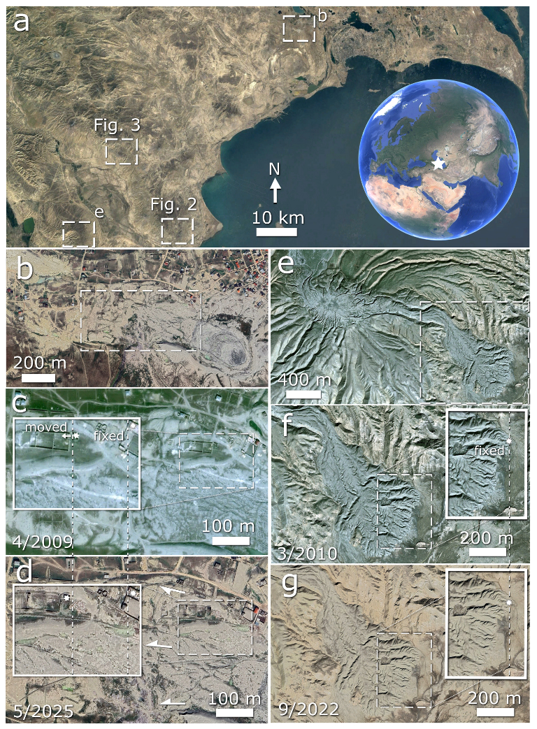
Figure 1Two contrasting types of MV behaviours in Azerbaijan as observed using Google Earth images. (a) Large scale satellite view of the targeted areas. (b) Bozdag Gobu (40.43° N and 49.70° E) exhibits a clear displacement of a part of its kilometre-sized mud flow over the period of 16 years (c, d). (e) Beyuk Mishovdag complex MV 2 (38.94° N and 49.08° E) has remained stable, showing no detectable downslope motion along the entire length of the flow over the 12-year observation period (f, g). Imagery © 2025 CNES/Airbus and 2025 Maxar technologies, Map data © 2025 Google Earth.
Table 1Overview of the MVs displaying evidence of creeping flow movement, including their basic morphological and morphometric characteristics, as well as details of their observed displacements. See the main text for details on how listed values have been measured. “Gradual” movement refers to cases where displacement becomes visible only when comparing the earliest and latest satellite images, while year-to-year changes remain too small to be detected. “Intermittent” movement describes MVs where each new satellite image shows a discernible change, sometimes eruption-related, sometimes not, with possible pauses in between. “Continuous” movement is restricted to structures such as Goturdag and a few similarly behaving MVs, where clear deformation is present throughout the full satellite time series.
Based on satellite data available in Google Earth, we also performed morphometric measurements listed in Table 1. Specifically, we used the satellite images to measure the total displacement by identifying a clearly recognizable feature within the mud flow and tracking the change in its position between the oldest and the most recent image pair (see Supplement GPS measurements).
We also used the available elevation data to determine the highest and lowest elevation points of each studied MV, from which we calculated the average slope of the volcanic edifice. The lowest point was defined as the mean value of four measurements taken at the base of the volcano. Similarly, the width of each volcano was estimated by creating four cross-sectional profiles and averaging the obtained values. Google Earth uses DEM data obtained from NASA's Shuttle Radar Topography Mission (Farr et al., 2007), with a spatial resolution of 10–30 m for the USA and approximately 90 m for the rest of the world, including Azerbaijan. The reported vertical error of these DEMs is less than 16 m (Jarvis et al., 2008). However, it should be noted that the use of such data may introduce certain limitations. The 90 m SRTM DEM is not optimal for analysing small-scale (∼ 500 m) or steep topographic features (Kervyn et al., 2008) as this may result in measurement uncertainties. In addition, the use of non-orthorectified historical imagery may introduce minor positional offsets between scenes, which could affect the apparent displacement of small-scale features. Nevertheless, these data are adequate for deriving approximate estimates of the height, and slope of kilometre-scale landforms as well as flow movements.
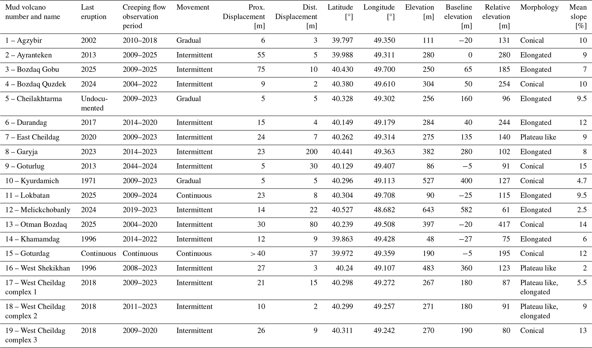
We also carried out field investigations at two MVs, Goturdag (in 2022 and 2025) and Durandag (in 2025), where satellite imagery indicated signs of such movements. Our objective was to locate and directly examine in the field, the contact zone between the creeping flow and the stable flanks (Figs. 2–3 and S1 to S3) to validate the satellite-based observations.
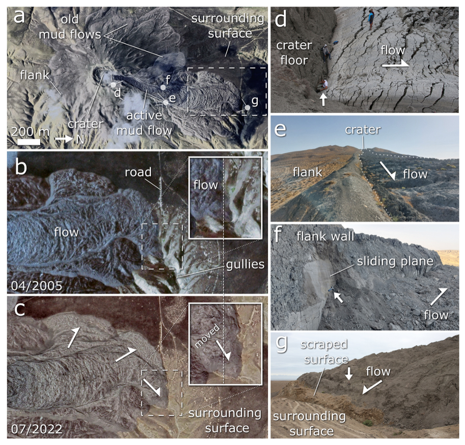
Figure 2Mud flow displacements at Goturdag MV (formerly known as Koturdagh) (39.97° N and 49.36° E), (a) general view of the MV with its crater, flanks, and the kilometre-sized mud flow with marked position of other panels; (b, c) close-up views of the terminal part of the mud flow in 2005 and 2022, respectively. Comparing the images a clear downslope displacement of the entire flow is evident; (d) mud breccia extrusion at the crater site, (e) contact between the mud flow and the surrounding slopes of the volcano, (f) detail of the sliding plane developed between the flank wall and the mud flow, and (g) close-up of the mud flow terminus, showing evidence of bulldozing surface scraping the surrounding host rock. Satellite panels (a)–(c) extracted copyrights: Imagery © 2025 Maxar Technologies, © 2025 CNES/Airbus, Map data © 2025 Google Earth.
Figure 3Mud flow displacements at Durandag MV (40.15° N and 49.18° E). (a) General view of the MV with its crater, flanks, and the kilometre-sized mud flow with marked position of other panels, (b, c) close-up views of the mud flow close to the crater area in 2014 and 2016, respectively, from which a downslope displacement of the flow is visible, (d) view to the crater area with the most recent mud flow, (e, f) the contact between the rim and mud flow, and (g) the terminal part of the mud flow. Panels (a)–(c) based on Google Earth. Imagery © 2025 Maxar Technologies, Map data © 2025 Google Earth.
Out of the total 47 MVs (see Supplement for KMZ file showing location of all studied edifices) investigated within the Caspian Basin, clear signs of creeping surface movements were identified in satellite data for 19 of them (see Table 1 and Fig. 4). This corresponds to ∼ 40 % of the surveyed population, indicating that creeping is not an isolated phenomenon. The highest frequency of eruptive activity during the study period was recorded at Lokbatan (MV 11), with at least 9 eruptions. Although the extensive analyses and observations conducted at Lokbatan MV are provided in Mazzini et al. (2026), for completeness we include this structure in our catalogue.
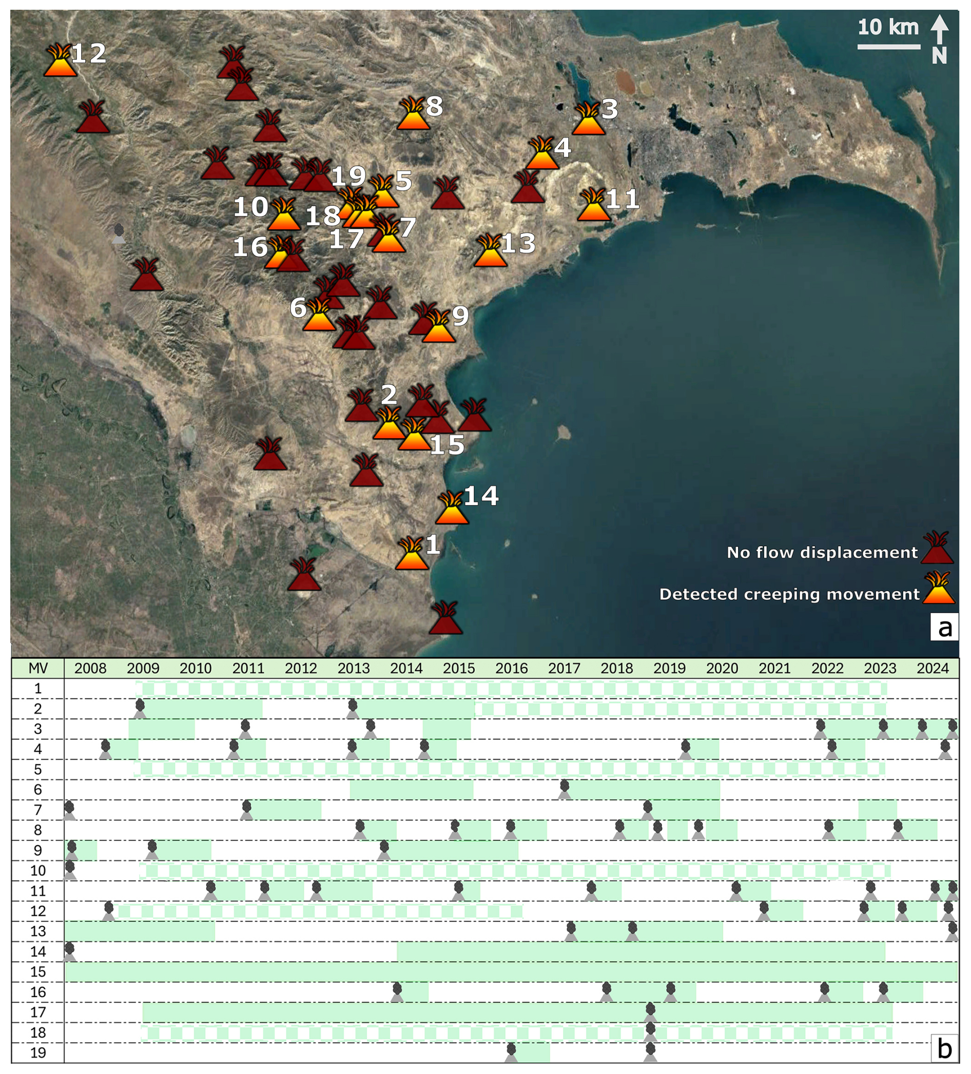
Figure 4(a) Satellite image with indicated MV locations. Imagery © 2025 Landsat/Copernicus, Map data © 2025 Google Earth. (b) Summary of eruption timelines based on published data (Aliyev et al., 2019; Department of Electronic Services, Information, and Public Relations, 2024a, b; Azerbaijani Institute of Geology and Geophysics, 2025) and satellite observations for each numbered MV. Periods of movement are shown in faded green; checkered faded green indicates that movement occurred, but its duration remains uncertain. The numbers correspond to MVs listed in Table 1 and shown in the Movies S1 to S19 in the Supplement: 1 – Agzybir, 2 – Ayranteken, 3 – Bozdaq Gobu, 4 – Bozdaq Quzdek, 5 – Cheilakhtarma, 6 – Durandag, 7 – East Cheildag, 8 – Garyja, 9 – Goturlug, 10 – Kyurdamich, 11 – Lokbatan, 12 – Melickchobanly, 13 – Otman Bozdaq, 14 – Khamamdag, 15 – Goturdag, 16 – West Shekikhan, 17 – West Cheildag complex 1, 18 – West Cheildag complex 2, 19 – West Cheildag complex 3.
For most MVs exhibiting creeping flow movement, the observed displacements can be linked to specific eruptive events (see Table 1 and Fig. 4). The few exceptions are Goturdag (MV 15), Khamamdag (MV 14) and West Cheildag 1 and 2 (MVs 17, 18), which continue to display clear deformation in satellite imagery over the entire studied period (Fig. 4). Goturdag also exhibits the greatest displacement: the deformation is so extensive that the movement can be distinctly observed in satellite images throughout the entire length of the flow (Fig. 2b–c). The most noticeable movement occurs near the crater outlet (Fig. 2d). The displacement is also clearly visible at the distal flow front, where a pronounced accretionary ridge forms as the advancing mud mass pushes and overrides the underlying substrate (Fig. 2g). The observed displacement in that area is approximately 37 m between 2004 and 2023. Field observations reveal a sharp boundary between the active flow and the stable flanks (Fig. 2e) with the sliding plane at their interface clearly exposed (Fig. 2f).
Most of the analysed MVs, however, displayed significantly lower movement rates (see Table 1 for details). For example, the creeping flow associated with Bozdaq Gobu (MV 3) shifted from 10 to 75 m between 2009 and 2025 depending on the position within the flow. Similarly, the mud flow associated with East Cheildag (MV 7) moved between 7 to 24 m between 2009 and 2023, flow on West Shekikhan (MV 16) advanced between 3 and 27 m from 2008 to 2023, and on Durandag (MV 6) about 4 to 15 m between 2014 and 2020. These examples highlight the substantial variability in creeping flow velocities among different MVs.
Creeping mud flow motions were observed regardless of slope inclination – they were active on slopes as gentle as 2° as well as on steeper flanks up to 15°. Similarly, we also observe that movement occurred independently of MV morphological type, as defined by Mazzini and Etiope (2017); displacements can be linked with elongated, conical, and plateau-like MVs alike.
Field observations revealed that although Durandag (MV 6) exhibits a surface morphology comparable to the flow associated with Goturdag (Fig. 3), no evidence of current movement was detected at the distal end of the paleo mud flow (Fig. 3g). The distal part of the flow appeared inactive, despite the occurrence of a recent eruption (Fig. 3d). The observed displacement of the flow, based on field (Fig. 3e–f) and satellite images, is (Fig. 3b–c) restricted to only part of the flow rather than its entire extent.
However, given the spatial resolution of the available imagery and DEM datasets, the minimum detectable displacement is estimated to be on the order of several metres, and smaller-scale movements may therefore remain unresolved.
Our investigations on MVs within the Caspian Basin reveals that creeping flow movements are a variably expressed phenomenon. Out of the 47 examined edifices, 19 show measurable deformation patterns consistent with slow, gravity-driven displacement of previously extruded mud breccia. This means that more than a third of the studied MVs exhibits this behaviour, indicating that this type of movement is a relatively widespread phenomenon within the studied region among kilometre-sized mud flows.
Among these, Lokbatan and Goturdag stand out as the most dynamically active structures. Goturdag exhibits continuous deformation across the entire flow length, indicating ongoing extrusion of the mud breccia and basal sliding, Lokbatan instead shows episodic movement that are periodically prompted (Mazzini et al., 2026). Even if some MVs display creeping behaviour without any eruptions like Goturdag, most behave similarly to the Lokbatan MV. For example, Garyja (MV 8) and Goturlug (MV 9), show the same behaviour, where creeping mud flows are observed after eruptions (see Fig. 4 and Movies S8 and S9 in the Supplement). Our results (Fig. 4) demonstrate a clear relationship between surface movement and eruptive events, thereby prompting the deformation of pre-existing flows. Although we cannot fully exclude that some of the detected surface changes reflect processes such as erosion or local collapse, the spatial coherence of the observed displacements and their repeated occurrence across multiple time steps strongly support a gravity-driven mechanism. This suggests that once a MV becomes inactive, creeping motion within paleo-flows slows significantly or ceases altogether. This conclusion agrees with Mazzini et al. (2026), who reported that the greatest displacement occurs near the time of eruption and diminishes over time.
Our findings also emphasise that creeping deformation is not restricted to a specific morphology or slope (Table 1), as can be seen while comparing e.g. Melickchobanly (MV12), with an approximate mean slope of 2°, and Otman Bozdaq with a mean slope around 14°. It represents a general post-eruptive adjustment mechanism that can significantly influence the long-term MVs evolution (Fig. 4).
The observed variation in displacement rates, from a few metres up to tens of metres per decade (Table 1), suggests that the efficiency of creeping flow is controlled by multiple factors, including eruption frequency, slope inclination, viscosity, and/or the volume of extruded mud breccia. The interplay of these factors likely causes individual kilometre-scale mud flows to respond differently to loading, which may explain subtle variations in the shape and behaviour of creeping flows, while the underlying movement mechanism remains consistent.
In some instances, the presence of megablocks (large portions of broken crater rims transported within the flow, i.e. Mazzini et al., 2021) can also obstruct and alter the homogeneous creeping mode of the mud flow. It is also worth noting here that the transport model proposed by Mazzini et al. (2021) suggests that these large megablocks were carried downslope during massive eruptions similar to what is observed in copious lava flows. Although the authors' model still stands, the progressive downslope movement of these blocks can also be explained by the mechanism presented herein.
Pre-eruptive ground deformations have been previously detected using InSAR on other MVs (e.g. Antonielli et al., 2014). However, our findings also demonstrate that the regions surrounding these MVs experience significant post-eruptive ground deformations associated with mud flow creep.
Although Azerbaijan is not the only region with kilometre-sized MVs (e.g., Baloglanov et al., 2018), our additional survey of major sites in Iran, Pakistan, Russia, and other locations revealed that comparable behaviour is not observed elsewhere. One exception is the Raznokol MV in Russia (45.144° N, 37.418° E), which exhibited creeping between 2017 and 2021. It remains unclear why so far, this creeping phenomenon is observed only in this Caspian region.
Several factors may promote this phenomenon in Azerbaijan. For example, the exceptionally large size of the MV edifices, the biggest on Earth, enables the formation of long mud flows with substantial mass, which in turn can enhance gravitational propagation. In addition, the positions of most MVs, as well as the orientations of their flows, are strongly influenced by underlying tectonic structures, particularly anticline axes. Many of these volcanoes also feature a single, dominant crater instead of multiple smaller, aligned eruptive vents, which may affect how material is discharged and distributed. The Caspian mud breccia itself is typically heterogeneous, and the generally weak meteoric erosion, especially when compared with MVs in tropical regions, might further preserve the morphology that facilitates this behaviour. Despite these possible explanations, the primary reason for the dominance of this phenomenon in Azerbaijan remains uncertain and dedicated studies are needed.
To validate our satellite observations, we installed a simple in-situ monitoring setup in August 2025 at two MVs with confirmed creeping flow activity, Durandag and Otman Bozdaq. At both sites, wooden sticks were deployed in linear transects across the sliding planes of the mud flows. Detailed information on installation dates, GPS coordinates, and accompanying photographs is provided in Table S1. This setup is intended to facilitate follow-up in situ long term measurements by future research teams, allowing independent refinement of surface displacement estimates for these creeping mud flows.
Social Impact
Although our research revealed that most creeping mud flows occur outside inhabited areas, we identified one MV (Bozdaq Gobu) whose creeping flow directly threatens nearby settlements (Fig. 1b–d). Nevertheless, the discovery of this movement mechanism, together with its widespread occurrence among Azerbaijani MVs, highlights a potentially significant geohazard, which was overlooked until now.
Azerbaijan hosts over 400 MVs, more than 300 of which are located on land (Jakubov et al., 1971; Aliyev et al., 2002, 2015). Many remain active and can erupt without warning, as demonstrated by recent events at Lokbatan (Mazzini et al., 2021), Bozdag-Guzdek (Odonne et al., 2020), and the Otman Bozdag eruptions in 2018 and 2025 (Odonne et al., 2021).
Our study shows that significant movement of paleo-mud flow features does not necessarily require major eruptions producing extensive mud outflows; instead, even minor releases from upper crater zones can trigger renewed motion in old flows, posing a risk to nearby areas.
The risk is particularly relevant when engineering structures, such as pipelines or power lines (i.e. see production installations at Lokbatan MV) are built across apparently “dead” mud flows under the false assumption that these terrains are stable (Fig. 5). Another example is Bozdag Gobu (MV3) in a populated region of Baku, where house displacements can be observed (Fig. 1 and Movie S3 in the Supplement) due to renewed mud flow activity by smaller scale eruptions during the last decade. Our findings highlight the need to raise awareness of this hidden hazard related to MVs, as also pointed out by Mazzini et al. (2023) for other structures.
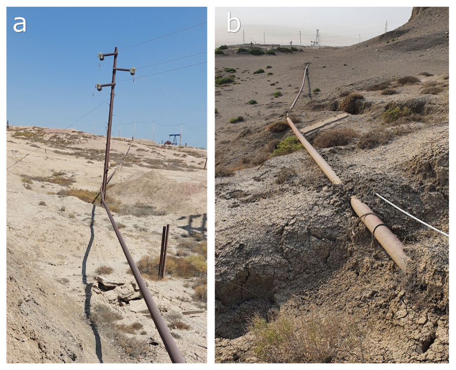
Figure 5Example of infrastructures built across the creeping mud flow at Lokbatan MV. (a, b) Ongoing flow movement causes deformation of the pipeline.
Future integration of InSAR data and in situ monitoring will be essential to quantify displacement rates with higher precision and to further constrain the underlying mechanisms.
We show that numerous MVs in Azerbaijan exhibit creeping movements associated with kilometre-sized mud flows. This mechanism, resembling the slow motion observed at warm-based glaciers, can be directly linked to the MV eruptive activity. These episodic events can periodically reactivate the creeping that can persist for several months afterward or continue relentlessly (e.g. Goturdag MV).
Our observations indicate that the greatest displacements are prompted by eruptive events, as proposed by Mazzini et al. (2026), and subsequently decrease and/or cease over time. This highlights a post-eruptive adjustment mechanism that shapes the long-term evolution of kilometre-sized mud flows. The rate and extent of this movement vary among individual MVs from few metres up to dozens of metres and appear to be influenced by factors such as eruption frequency, slope gradient, and/or subsurface fluid availability. While creeping mud flows are largely observed in Azerbaijan, we cannot exclude a similar behaviour in other large-scale structures elsewhere or on other planetary bodies.
Although many of the MVs featuring creeping mud flows are located away from highly populated areas, numerous settlements and infrastructures can be observed within or at the outskirts of some mud flows (e.g. Bozdaq Gobu, Lokbatan Otman Bozdag), posing potential hazards. These findings underscore the need for continued monitoring, broader studies, and increased awareness of this hidden risk.
The data are provided in the Supplement.
The Supplement includes:
-
Movies Movie_S1_Agzybir.mp4 to Movie_S19_West_Cheildag_Complex_3.mp4 in the Supplements.
-
Table S1 (GPS positions of sticks on two mud volcanoes).
-
Photos of the planted sticks (Figs. S1, S2, S3).
-
Zip to google earth mud volcano pins S_Google_earth_pins.
The supplement related to this article is available online at https://doi.org/10.5194/esurf-14-433-2026-supplement.
CF: conceptualisation, investigation, methodology, visualisation, writing (original draft). PB: conceptualisation, funding acquisition, investigation, methodology, visualisation, writing (original draft). AM: conceptualisation, funding acquisition, investigation, validation, writing (original draft).
The contact author has declared that none of the authors has any competing interests.
Publisher's note: Copernicus Publications remains neutral with regard to jurisdictional claims made in the text, published maps, institutional affiliations, or any other geographical representation in this paper. The authors bear the ultimate responsibility for providing appropriate place names. Views expressed in the text are those of the authors and do not necessarily reflect the views of the publisher.
The authors thank the two reviewers, Daniele Spatola and an anonymous reviewer, for their constructive feedback on the manuscript, and Wolfgang Schwanghart and Greg Hancock for handling the editorial process.
PB was supported by Space for the Mankind of Strategy 21 of the Czech Academy of Sciences during the 2025 field campaign. We acknowledge the support from the Research Council of Norway through the HOTMUD (project number 288299), the NCS2030 (project number 331644), and the WELLFATE (project number 344447).
This paper was edited by Greg Hancock and reviewed by Daniele Spatola and one anonymous referee.
Aliyev, A., Guliev, I. S., and Belov, I. S.: Catalogue of recorded eruptions of mud volcanoes of Azerbaijan. Nafta Press, Baku, 87 pp., 2002.
Aliyev, A., Guliev, F., Dadashov, F. G., and Rahmanov, R. R.: Atlas of the world mud volcanoes, Nafta Press, ISBN 978-9952-437-60-7, 2015.
Aliyev, A., Guliyev, I. S., and Rahmanov, R. R.: Catalogue of mud volcanoes eruptions of Azerbaijan (2008–2019), Academic Council of Institute of Geology and Geophysics of Azerbaijan National Academy of Sciences 128 pp., 2019.
Antonielli, B., Monserrat, O., Bonini, M., Righini, G., Sani, F., Luzi, G., Feyzullayev, A. A., and Aliyev, C. S.: Pre-eruptive ground deformation of Azerbaijan mud volcanoes detected through satellite radar interferometry (DInSAR), Tectonophysics, 637, 163–177, 2014.
Azerbaijani Institute of Geology and Geophysics: OTMAN BOSDAQ MUD VOLCANO Erupts Again, http://gia.az/news/detail/4651/otmanbozdag-palciq-vulkani-yeniden-puskurub (last access: 5 April 2026), 2025.
Baloglanov, E. E., Abbasov, O. R., and Akhundov, R. V.: Mud volcanoes of the world: classifications, activities and environmental hazard (informational–analytical review), European Journal of Natural History, 5, 12–26, 2018.
Cuffey, K. M. and Paterson, W. S. B.: The Physics of Glaciers, 4th edn., Academic Press, ISBN 978-0080-919-12-6, 2010.
Department of Electronic Services, Information, and Public Relations: An eruption of the Guzdek-Bozdag mud volcano was recorded, https://seismology.az/en/news/an-eruption-of-the-guzdek-bozdag-mud-volcano-was-recorded/383 (last access: 5 April 2026), 2024a.
Department of Electronic Services, Information, and Public Relations: The ANAS Regional Center for Seismic Monitoring of Mud Volcanoes registered an eruption of the Melikchobanly mud volcano, https://seismology.az/ru/novosti/set-seismiceskogo-monitoringa-gryazevyx-vulkanov-rcss-nana-zaregistrirovala-izverzenie-gryazevogo-vulkana-melikcobanly/366 (last access: 5 April 2026), 2024b.
Farr, T. G., Rosen, P. A., Caro, E., Crippen, R., Duren, R., Hensley, S., Kobrick, M., Paller, M., Rodriguez, E., Roth, L., Seal, D., Shaffer, S., Shimada, J., Umland, J., Werner, M., Oskin, M., Burbank, D., and Alsdorf, D.: The Shuttle Radar Topography Mission, Rev. Geophys., 45, RG2004, https://doi.org/10.1029/2005RG000183, 2007.
Ghaderi, D. and Rahbani, M.: Mud volcano as a feature of emergence in Caspian Sea, Oceanologia, 64, 503–513, 2022.
Google Inc.: Google Earth (Version 7.3.6.10201), http://www.google.com/earth/ (last access: 5 April 2026), 2025.
Huseynov, D. A. and Guliyev, I. S.: Mud volcanic natural phenomena in the South Caspian Basin: geology, fluid dynamics and environmental impact, Environ. Geol., 46, 1012–1023, 2004.
Jakubov, A. A., Alizade, A. A., and Zeinalov, M. M.: Mud volcanoes of the Azerbaijan SSR: Atlas, Azerbaijan Academy of Sciences, Baku, 1971 (in Russian).
Jarvis, A., Reuter, H. I., Nelson, A., and Guevara, E.: Hole-filled SRTM for the globe Version 4, CGIAR Consortium for Spatial Information, http://www.cgiar-csi.org/data/elevation/item/45-srtm-90m-digital-elevation-database-v41 (last access: 27 May 2026), 2008.
Kervyn, M., Ernst, G. G. J., Goossens, R., and Jacobs, P.: Mapping volcano topography with remote sensing: ASTER vs. SRTM, Int. J. Remote Sens., 29, 6515–6538, https://doi.org/10.1080/01431160802167949, 2008.
Kirkham, C., Cartwright, J., Hermanrud, C., and Jebsen, C.: The spatial, temporal and volumetric analysis of a large mud volcano province within the Eastern Mediterranean, Mar. Petrol. Geol., 81, 1–16, 2017.
Kopf, A. J.: Significance of mud volcanism, Rev. Geophys., 40, 2-1–2-52, https://doi.org/10.1029/2000RG000093, 2002.
Mazzini, A. and Etiope, G.: Mud volcanism: An updated review, Earth-Sci. Rev., 168, 81–112, https://doi.org/10.1016/j.earscirev.2017.03.001, 2017.
Mazzini, A., Akhmanov, G., Manga, M., Sciarra, A., Huseynova, A., Huseynov, A., and Guliyev, I.: Explosive mud volcano eruptions and rafting of mud breccia blocks, Earth Planet. Sc. Lett., 555, 116699, https://doi.org/10.1016/j.epsl.2020.116699, 2021.
Mazzini, A., Sciarra, A., Lupi, M., Ascough, P., Akhmanov, G., Karyono, K., and Husein, A.: Deep Fluids Migration and Submarine Emersion of the Kalang Anyar Mud Volcano (Java, Indonesia): A Multidisciplinary Study, Mar. Petrol. Geol., 148, 105970, https://doi.org/10.1016/j.marpetgeo.2022.105970, 2023.
Mazzini, A., Brož, P., Lupi, M., Břežný, M., Jodry, C., Sfalcin, J., Fenske, C., Morelli, G., Fischanger, F., Khasayeva Huseynova, A., and Huseynov, A.: Mud volcanism and creepy mud flows: a new model, Geology, in review, 2026.
Odonne, F., Imbert, P., Dupuis, M., Aliyev, A. A., Abbasov, O. R., Baloglanov, E. E., Vendeville, B. C., Gabalda, G., Remy, D., Bichaud, V., and Juste, R.: Mud volcano growth by radial expansion: Examples from onshore Azerbaijan, Mar. Petrol. Geol. 112, 104051, https://doi.org/10.1016/j.marpetgeo.2019.104051, 2020.
Odonne, F., Imbert, P., Remy, D., Gabalda, G., Aliyev, A. A., Abbasov, O. R., Baloglanov, E. E., Bichaud, V., Juste, R., Dupuis, M., and Bonvalot, S.: Surface structure, activity and microgravimetry modelling delineate contrasted mud-chamber types below flat and conical mud volcanoes from Azerbaijan, Mar. Petrol. Geol., 134, 105315, https://doi.org/10.1016/j.marpetgeo.2021.105315, 2021.
Planke, S., Svensen, H., Hovland, M., Banks, D. A., and Jamtveit, B.: Mud and fluid migration in active mud volcanoes in Azerbaijan, Geo-Mar. Lett., 23, 258–268, https://doi.org/10.1007/s00367-003-0152-z, 2003.